Report on Ubinas (Peru) — October 2016

Bulletin of the Global Volcanism Network, vol. 41, no. 10 (October 2016)
Managing Editor: Edward Venzke.
Edited by A. Elizabeth Crafford.
Ubinas (Peru) Ash plumes to 8 km during April-October 2015; activity ends in February 2016
Please cite this report as:
Global Volcanism Program, 2016. Report on Ubinas (Peru) (Crafford, A.E., and Venzke, E., eds.). Bulletin of the Global Volcanism Network, 41:10. Smithsonian Institution. https://doi.org/10.5479/si.GVP.BGVN201610-354020
Ubinas
Peru
16.345°S, 70.8972°W; summit elev. 5608 m
All times are local (unless otherwise noted)
Ubinas is an active stratovolcano in southern Peru about 70 km E of the city of Arequipa. Although Holocene lava flows cover its flanks, the historical record, which extends back to the mid-1500's, contains evidence of minor explosive eruptions, debris avalanches, tephra deposits, phreatic outbursts, and pyroclastic flows and lahars. Recently, an extended series of ash eruptions occurred between March 2006 and August 2009. Phreatic explosions were again reported between September 2013 and November 2014 (BGVN 40:12), including large explosions between April and June 2014 that caused ash plumes to rise above 10 km altitude, large SO2 anomalies, evacuations, and several millimeters of ashfall in surrounding villages. This report details subsequent activity from January 2015 through April 2016 with information provided largely by Instituto Geofísico del Perú, Observatoria Vulcanologico del Sur (IGP-OVS), the Observatorio Volcanológico del INGEMMET (Instituto Geológical Minero y Metalúrgico) (OVI-INGEMMET), and the Buenos Aires VAAC (Volcanic Ash Advisory Center).
Minor ash emissions were reported on 15 January, 18-19 February, and 17 March 2015. A more substantial explosion with an ash plume on 8 April was followed by an extensive series of seismic tremors with ongoing ash emissions for several days; several millimeters of ash were deposited in the surrounding villages to the SE, up to 10 km away. Persistent ash emissions continued in May and June 2015, with ashfall in surrounding villages. A large explosion on 25 July ejected ash, lapilli, and bombs, and affected communities 20 km away. Continuous ash emissions in August and September accompanied heightened seismicity. Emissions began to decrease in October, and the last ash emission of the year was reported on 18 November.
Significant MIROVA thermal anomalies were first observed in mid-June and were sporadic through mid-November when they increased and persisted through January 2016. The last explosion was reported on 15 January, although a minor ash emission was reported on 27 February 2016. The seismic energy decreased substantially after 1 March 2016, and IGP-OVS and OVI-INGEMMET reduced the Alert level from Orange to Yellow (on a 4 level scale) on 30 April 2016.
Activity during January-March 2015. Low- to medium-density steam emissions rising to between 500 and 1,100 m above the summit crater floor were typical in January 2015, along with intermittent bluish magmatic gas emissions. OVI-INGEMMET reported blue SO2 emissions on 15 January in their weekly report. In their monthly summary, they referred to 'two light gray emissions with slight ash content' on that day, and a plume height of 1,500 m above the crater. The background level of seismic energy increased after 6 January from about 3 MJ (megajoules) to 25 MJ, according to IGP-OVS weekly reports. OVI-INGEMMET reported three small lahars, one on 21 January in Chiflon ravine and two on 31 January in Volcánmayo creek (SE of the volcano), which caused damage to the road linking the towns of Querapi and Ubinas, a few kilometers SE.
In February 2015, seismicity decreased somewhat according to IGP-OVS weekly reports. Cloudy skies for much of the month prevented detailed observations of emissions which generally rose to heights of 200 to 500 m. Diffuse emissions consisted primarily of water vapor with an occasional bluish SO2 component according to IGP-OVS. The highest emission was 1,000 m on 6 February according to the OVI-INGEMMET monthly report for February; they also reported minor amounts of ash in the emissions from the volcano on 18 and 19 February, but no ashfall in neighboring communities. Two lahars descended drainages on the SE side of the volcano on 6 February and caused damage near Tonohaya (10 km SE) and to the access road to the village; another lahar reported on 13 February in Volcánmayo creek was reported by villagers as 1.6 m deep.
OVI-INGEMMET noted that a villager in Ubinas (6.5 km SSE) reported another lahar on Volcánmayo creek on 7 March 2015. Emissions during March rose to between 400 and 1,500 m above the summit crater, and were low- to medium-density, consisting primarily of water vapor. IGP-OVS reported sporadic ash emissions on the morning of 17 March. There was no associated ashfall in the vicinity. Volcano-tectonic (VT) earthquakes showed an upward trend from the beginning of February into the first week of March. Two main foci were observed, the first located 2 km NW of the crater at depths between 1 and 5 km, the second 1 km W of the crater between 1 and 3 km deep. In the last week of March, the numbers of LP and Hybrid earthquakes each increased 10-fold from the previous week's measurements, and bluish magmatic gas emissions were observed on 30 and 31 March.
Activity during April-June 2015. Strong SO2 odors were reported in Phara (5 km E) at the very beginning of April 2015. The number of LP and Hybrid-type seismic events continued a steady increase that began the third week in March. Pulsing emissions of water vapor and magmatic gases rose to between 500 and 900 m above the summit during the first week in April. On 8 April at 0332 local time IGP-OVS reported a small explosion that initiated a sequence of constant seismic tremors and ash emissions that lasted for 41 hours (figure 27). This was followed by four days (11-14 April) of pulsing ash emissions and seismic tremors. OVI-INGEMMET reported 12 minor explosions between 8 and 12 April during the constant tremors. Very little wind caused the ash column to rise nearly vertically to 2,500 m above the crater. Ash deposits up to 1.5 cm thick were noted in Ubinas (6 km SE), Escacha (10 km SE), and elsewhere in the Ubinas valley (figure 28).
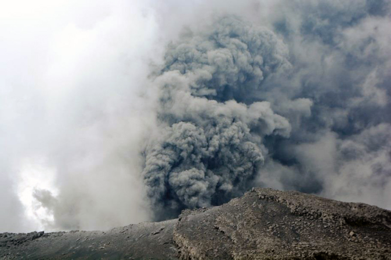 |
Figure 27. IGP-OVS scientists were in the area of Ubinas on the morning of 8 April 2015 when the volcano erupted with a dense ash plume rising over 2,000 m. Courtesy of IGP-OVS (Ubinas Report 16, 8 April 2015). |
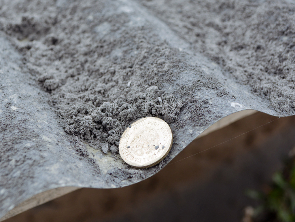 |
Figure 28. Photo of a tin roof in the town of Ubinas (6 km SE of crater), with ash deposits approximately 1.5 mm thick from the 8 April 2015 explosion. Courtesy of IGP-OVS (Ubinas 2015 Annual Report). |
An isopach map of ash thickness from explosions beginning on 8 April was generated by IGP-OVS scientists between 9 and 10 April; they estimated the ashfall at 650,000 m3. In a joint announcement on 10 April, IGP-OVS and OVI-INGEMMET reported that field observations on 8 and 9 April revealed pyroclastic fragments 20-40 cm in diameter in areas 200 m N of the crater. In addition, ash deposit thicknesses were more than 5 cm inside the crater, 3 cm at the edge of the crater, 1 cm above elevations of 4,800 m, and 1 mm in areas 6 km away in Ubinas. Trace ash deposits were observed as far away as Anascapa (10 km SE) (figure 29).
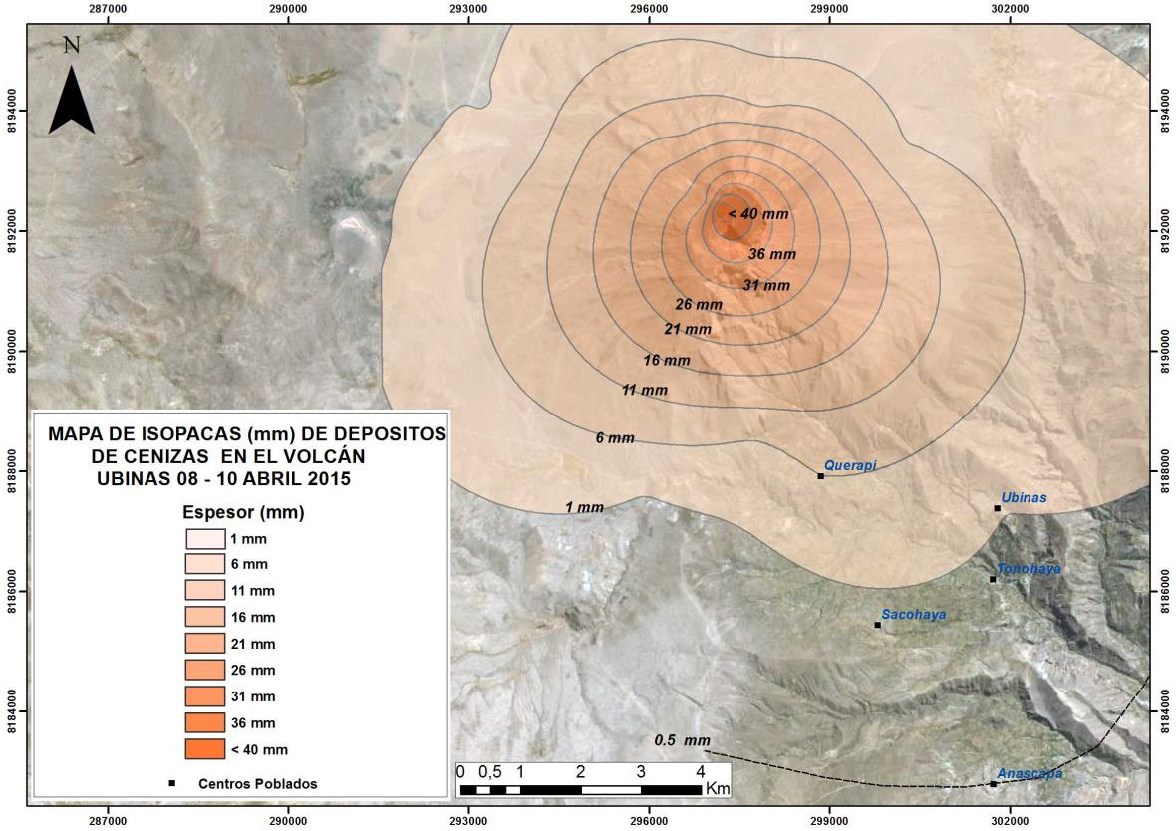 |
Figure 29. Isopach map of ashfall deposit thickness from Ubinas, with information gathered between 9 and 10 April 2015 after an initial explosion on 8 April. The total volume of ash was calculated as 650,000 m3. Courtesy of IGP-OVS (Ubinas Report 17, 14 April 2015). |
In a joint announcement on 17 April, IGP-OVS and OVI-INGEMMET reported six explosions between 12 and 17 April with nearly-constant ash emissions between 1,000 and 3,500 m above the summit crater, and ashfall in the local villages within 15 km. The Buenos Aires VAAC (Volcanic Ash Advisory Center) reported an ash plume on 14 April extending 35-40 km E from the summit at an altitude of 6.4 km, and another plume on 17 April rising to 7.6 km and drifting SE. The largest explosion on 15 April released 24.5 MJ of energy and sent an ash plume 3.5 km above the summit. This series of explosions led the authorities to raise the Alert Level at the volcano to Orange (second highest on a 4-color scale). Ash emissions continued at decreased levels during the third week of April according to both OVI-INGEMMET and IGP-OVS, with plumes not rising beyond 1,000 m above the summit crater; minor ashfall was still reported in nearby villages. Even though no explosions were reported after 20 April, persistent tremors continued at a lower level according to IGP-OVS, while other types of seismicity declined significantly (figure 30) from earlier in April.
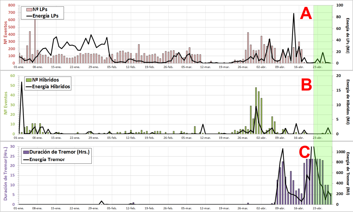 |
Figure 30. Earthquake numbers (color bars) and energy (black line) for major volcanic events recorded by the telemetric station UB1 between 1 January and 28 April 2015 at Ubinas. Courtesy of IGP-OVS (Ubinas Report 19-28 April 2015). |
New lahars descended the Volcanmayo drainage on the S flank during 12-13 April to a distance of 10 km, affecting agricultural land, irrigation canals, and roads as a result of the large volumes of ashfall and abundant snowfall followed by plentiful solar radiation. A video of the 13 April lahar was recorded (www.youtube.com/watch?v=kDdguKyKr4Q) by IGP-OVS.
According to IGP-OVS, ash emissions increased on 1 May 2015, rising to 800 m above the summit. Frequent seismic tremors with increasingly dense, intermittent ash-and-water-vapor plumes rising to between 1,100 and 1,800 m continued into the third week of May. OVI-INGEMMET reported a 1,100 m plume on 11 May that drifted E and NE, causing ashfall in Ubinas, Santa Rosa de Phara, and Eschacha (5-10 km E and S). IGP-OVS scientists visited between 20 and 22 May to conduct geophysical measurements and hold an educational workshop for local authorities. They observed water vapor, gas, and 400-m-high ash emissions during this time (figure 31).
 |
Figure 31. Steam-and-gas emissions from Ubinas during an IGP-OVS visit during 20-22 May 2015. Courtesy of IGP-OVS (Ubinas 2015 Annual Report). |
IGP-OVS reported two emissions on 24 May, and a significant increase in VT seismic events on 25 May. The Buenos Aires VAAC reported continuous emissions of steam with diffuse ash rising to an altitude of 6 km (400 m above the summit) and drifting 100 km ENE on 23 May, and emissions to 6.4 km drifting 30 km SE the next day. Additional emissions with bursts of fine ash and bluish gases on 29 and 30 May led to a greater volume of total ash emission than the previous week, although the plumes only rose to 400 m (figure 32).
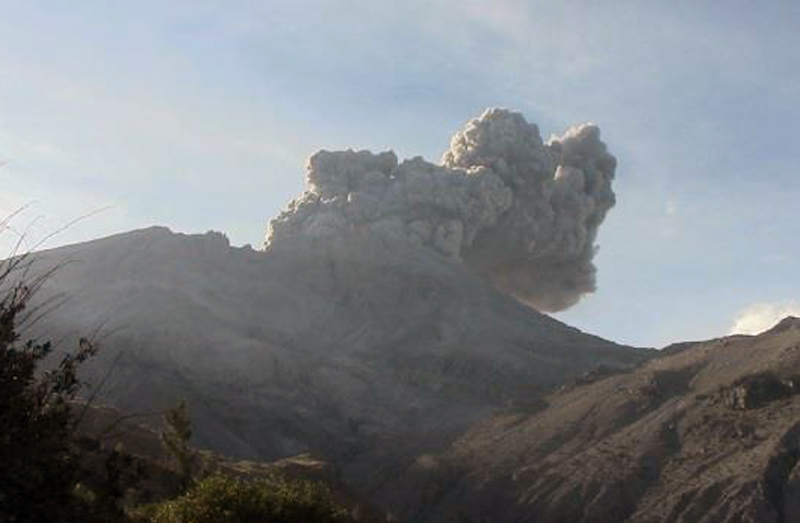 |
Figure 32. Emission of a dense ash plume from Ubinas on 29 May 2015. Courtesy of IGP-OVS (2015 Ubinas Report 24, 2 June 2015). |
Pulsing ash emissions and a sudden increase to 748 LP seismic events were recorded by IGP-OVS on 1 June 2015. VT seismic event frequency was also very high during the first week in June. IGP-OVS reported five ash emission events between 3 and 5 June with plume heights to 1,200 m above the summit. These events were reported by the Buenos Aires VAAC as continuous emissions rising to 7 km and drifting 30 km E. IGP-OVS noted that LP seismic events decreased dramatically from an average of 778 per day in the first week to 62 per day in the second week. In their annual report, IGP-OVS pointed out that a spike in hybrid-type seismic events on 14 June occurred a few hours prior to a thermal anomaly that was recorded by the MIROVA system (figure 33).
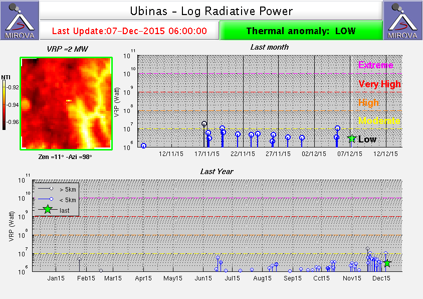 |
Figure 33. MIROVA Log Radiative Power thermal anomaly data for Ubinas. Upper graph shows 7 November through 7 December 2015, lower graph is from 8 December 2014 through 7 December 2015 and shows the first thermal anomaly reported by IGP-OVS on 14 June 2015. Courtesy of MIROVA (Taken from OVI-INGEMMET 2015 Weekly Report 49, 30 November-6 December). |
During the second week of June, OVI-INGEMMET noted that ash emissions were minor and continuous with fine, light gray or white ash, and bluish magmatic gases; the plumes rose from 300 to 1,300 m above the summit. Constant ash emissions from 9 to 11 June rose to 1,400 m above the summit. The Buenos Aires VAAC reported a brief emission on 17 June of olcanic ash that rose to 6.1 km. OVI-INGEMMET reported that large quantities of ash were emitted during 20-22 June in plumes rising to 1,800 m; ashfall was reported in the villages in the Ubinas Valley to the SE. Eight ash-emission events were recorded on 22 June by IGP-OVS, rising to 2,000 m above the summit (7,670 m altitude). The Buenos Aires VAAC also reported continuous and sporadic emissions during 20-22 June to 6.7 km altitude. During the last week of June, IGP-OVS noted that four explosions occurred between 24 and 27 June with emissions rising to 3,000 m above the summit (8,670 m altitude), and that 13 emission events occurred on 28 June. The Buenos Aires VAAC reported an explosive eruption on 28 June with a plume to 7 km altitude, and continuous emissions over the next few days rising to 6.7 km and drifting E.
Activity during July-September 2015. During early July 2015, decreasing tremors and ash emissions with plumes to 2,500 m were typical according to OVI-INGEMMET. On 1 July the Buenos Aires VAAC reported ongoing emissions rising to an altitude of 6.7 km and drifting SE. An explosion on 3 July caused ashfall in Ubinas to the SE. Larger events on 9 and 11 July emitted denser plumes that were observed by the Buenos Aires VAAC rising to 6.7 and 7.6 km. Increasing amounts of SO2 were also measured in the first half of July rising to between 2,500 and 4,900 metric tonnes per day (t/d), an increase from previous background levels of a few hundred t/d. A dense ash plume from an explosion observed by OVI-INGEMMET on 16 July caused ashfall in Ubinas; the Buenos Aires VAAC reported its plume to nearly 8 km altitude and drifting E (figure 34).
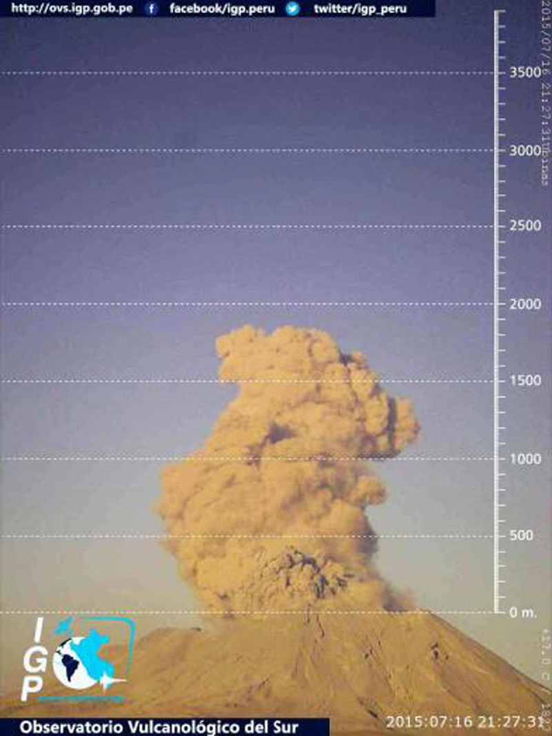 |
Figure 34. Explosion at Ubinas captured by the IGP-OVS Webcam on 16 July 2016. The ash plume was reported by Buenos Aires VAAC as eventually rising to over 8 km altitude. Courtesy of IGP-OVS (2015 Weekly Report 31, 21 July 2015). |
Seismic activity decreased for the first two weeks of July before a sudden and large increase in LP, hybrid, and VT events during 19-20 July. They also noted a sharp decrease in RSAM values for 14 hours prior to a significant explosion that occurred at 1903 local time on 25 July. The explosion registered at 507 MJ of energy, the largest of 2015, and ejected ash, lapilli, and bombs to the SE. Fragments of incandescent rocks were observed S and E of the crater (figure 35), and ashfall was reported up to 20 km away. Ash deposits 3 mm thick were observed in Ubinas and Escacha, along with lapilli fragments as large as 1.5 cm. The explosion was heard and felt in Querapi and Ubinas. It was followed by a second smaller explosion one hour later. The plume from the second event was reported to rise 4,000 m above the crater by OVI-INGEMMET (9,670 m altitude). Continuous bluish gas emissions were reported by IGP-OVS for the 48 hours following the 25 July explosions, after which intermittent bluish gases were frequently observed with plume heights rising to 1,000 m above the crater.
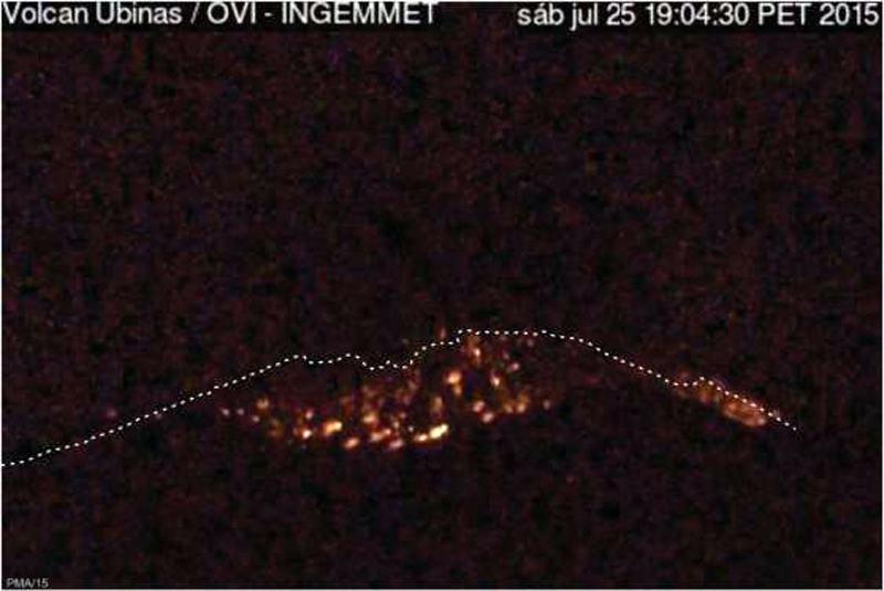 |
Figure 35. Incandescent bombs ejected S and E from the crater at Ubinas on 25 July 2015 at 1903 local time. Courtesy of OVI-INGEMMET (Weekly Report 31, 20 July -2 August 2015). |
IGP-OVS scientists conducted a field visit during 5-7 August 2015 and observed impact craters from volcanic bombs ejected during the 25 July explosion that were up to 2 m in diameter as far as 1.4 km from the crater. A moderate ash plume on 6 August that drifted NNE at 6.7 km altitude was the only plume reported by the Buenos Aires VAAC in August. IGP-OVS noted continuous tremors for 36 hours beginning on 10 August with minor ash emissions and a significant increase in VT and hybrid-type earthquakes during the second week. OVI-INGEMMET reported dense and continuous emissions of ash, steam, and gases throughout the month. The highest ash plumes of 2,300 m above the crater were observed on 27 August.
The first three weeks of September 2015 saw intermittent ash emissions to 1,500 m reported by IGP-OVS. The Buenos Aires VAAC reported a narrow, diffuse ash plume on 6 September at 6.1 km altitude extending 25 km ENE. The pulsing ash emissions observed by IGP-OVS on 9 and 10 September were recorded by the Buenos Aires VAAC as an irregular puff rising to 6.1 km. They also noted an explosive puff to 6.7 km on 21 September. This event correlated with an increase in hybrid, VT, and LP-type seismic events recorded by IGP-OVS which began on 20 September. This was followed by a large (53 MJ) explosion on 28 September that emitted a significant amount of ash and gas to 4,000 m (figure 36). Ashfall from this explosion was reported in Querapi (4.5 km SE), Ubinas, Tonohaya (7 km SSE), Anascapa (11 km SE), Sacohaya, and San Miguel (10 km SE). The Buenos Aires VAAC reported a plume drifting NE that rose to 8.2 km from this event, followed by another explosive eruption on 29 September with a plume that rose to 7.3 km. IGP-OVS reported another explosion on 30 September with an ash plume that rose to 1,400 m above the crater.
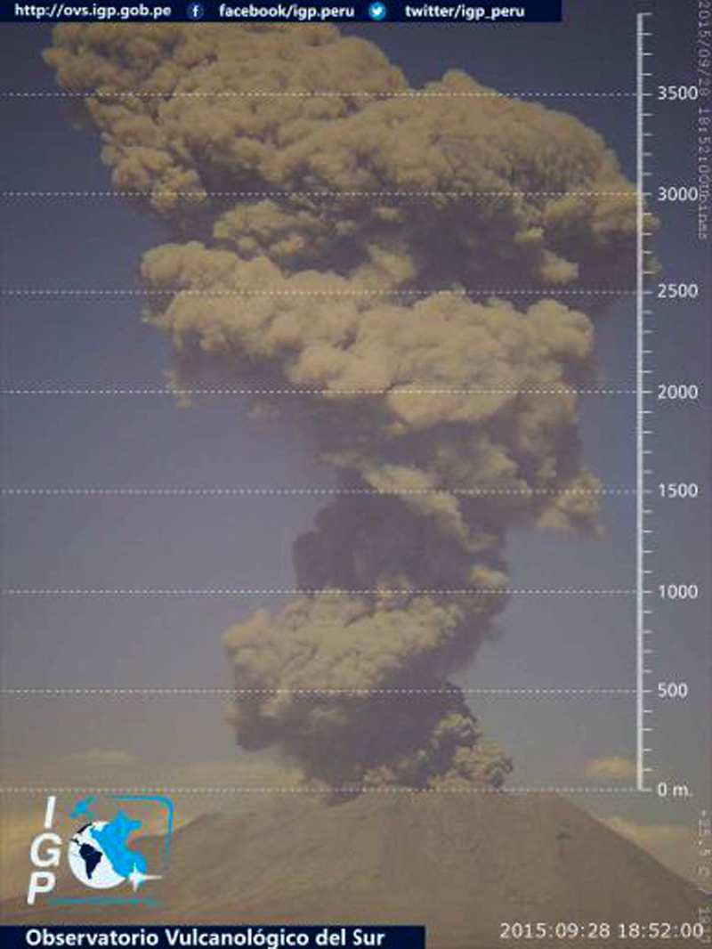 |
Figura 36. Webcam image of the explosion at Ubinas that occurred on 28 September 2015 beginning at 1345 local time. The plume height exceeded 3,500 m. Courtesy of IGP-OVS (2015 Weekly Report 41, 29 September 2015. |
Activity during October-December 2015. Both seismicity and ash emissions decreased during October 2015. The largest ash emissions (reported by IGP-OVS) were caused by five explosions with plumes to 2,000 m above the crater on 15 October. Pulsing ash emissions were also observed by OVI-INGEMMET on 21 October to 1,000 m, drifting NE and E. The Buenos Aires VAAC reported an ash plume to 6.1 km altitude from this event. Bluish magmatic gases and water vapor were emitted to 1,100 m above the summit frequently during the month. Six thermal anomalies were recorded by the MIROVA system (figure 33) in October. Seismicity of LP seismic events increased to 664 events on 30 October. OVI-INGEMMET reported large amounts of ash and gas emissions on 29 and 31 October (figure 37).
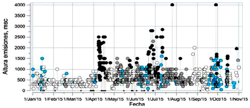 |
Figure 37. Emission heights and content at Ubinas from 1 January to 1 November 2015. Heights are measured above the crater in meters. White circles signify water vapor, blue circles are magmatic gases, gray circles are diffuse ash, and black circles are dense ash emissions. The 25 July and 28 September emissions produced the tallest plumes at 4,000 m. Courtesy of OVI-INGEMMET (Ubinas 2015 Weekly Report 45, 2-8 November 2015). |
The numbers of daily LP and hybrid seismic events were high at the beginning of November 2015 until a moderate 12 MJ explosion on 5 November that sent an ash plume to 2,200 m above the crater. The Buenos Aires VAAC recorded the explosive eruption on 5 November with a 7.3 km plume that drifted SE. This was followed by pulses of ash emissions until 8 November according to IGP-OVS. Sporadic ash emissions were again observed on 13, 14, and 18 November with the highest plume rising to 1,500 m and drifting S and SW on 13 November. They reported steady declines in the numbers of LP seismic events after 18 November, and emissions of only blue magmatic gases and water vapor. OVI-INGEMMET reported continuous plumes to 1,100 m in the last week of November comprised of gases, water vapor, and possible ash. More frequent MIROVA thermal anomalies appeared in mid-November to stronger levels than previously seen, suggesting to IGP-OVS the possible presence of a magma body near or at the base of the crater (figure 33).
No ash emissions were reported in December 2015. Instead, mild continuous emissions to 1,200 m of bluish magmatic gases and water vapor were reported by IGP-OVS and OVI-INGEMMET. IGP-OVS noted a large number of VT seismic events in December. They were located on the NW side of the crater, 1-3 km deep. Their scientists visited the crater on 23 December and remotely recorded temperatures of 454°C at the base of the crater. They observed intense emissions of magmatic gases from the bottom and side walls of the crater (figure 38). MIROVA thermal anomalies increased in mid-November and remained elevated through December (figure 39).
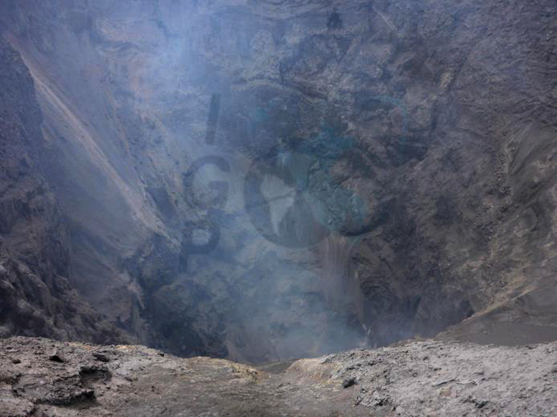 |
Figure 38. Emissions of magmatic gases from the base and walls of the crater at Ubinas on 23 December 2015. Courtesy of IGP-OVS (Weekly Report 54, 29 December 2015). |
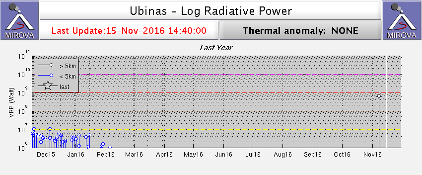 |
Figure 39. Log Radiative Power of MIROVA thermal anomalies at Ubinas from 16 November 2015 to 15 November 2016. The thermal anomaly signature persisted through mid-January before tapering off in the first week of February 2016. Courtesy of MIROVA. |
Activity during January-April 2016. Emissions of bluish magmatic gases to 1,800 m above the crater continued into January 2016 along with thermal anomalies recorded by the MIROVA system (figure 39). LP seismic events increased in the second week of January followed by an 11 MJ explosion on 15 January that sent an ash plume to 3,000 m above the crater, drifting S and SW. This explosion was preceded by ash emissions to 500 m a few hours earlier in the day. After the explosion, seismicity decreased, and emissions consisted of water vapor and bluish magmatic gases which rose no higher than 1,000 m for the remainder of the month.
Low seismicity, and water vapor and bluish magmatic gas plumes no higher than 1,100 m were typical behavior for February 2016. On 27 February small pulses of seismic tremor were recorded and small emissions of ash were observed, according to the IPG-OVS weekly report. OVI-INGEMMET reported a lahar on 12 February, and IGP-OVS reported several in the third week of the month that descended the Volcanmayo ravine on the S flank of the volcano.
Seismicity was very low, with only sporadic water vapor emissions, small quantities of bluish magmatic gases, and plume heights below a few hundred meters in March and April 2016. This led IGP-OVS and OVI-INGEMMET to jointly reduce the Alert Level from Orange to Yellow (3 to 2 on a 4-level scale) on 30 April 2016. The energy released by the volcano was in steady decline from the beginning of March 2016 (figure 40).
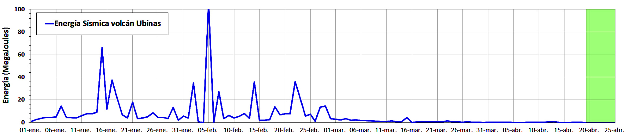 |
Figure 40. Total Seismic Energy (blue line) calculated for Ubinas from 1 January to 25 April 2016. Courtesy of IGP-OVS (Ubinas 2016 Report 17, 26 April 2016). |
Geological Summary. The truncated appearance of Ubinas, Perú's most active volcano, is a result of a 1.4-km-wide crater at the summit. It is the northernmost of three young volcanoes located along a regional structural lineament about 50 km behind the main volcanic front. The growth and destruction of Ubinas I was followed by construction of Ubinas II beginning in the mid-Pleistocene. The upper slopes of the andesitic-to-rhyolitic Ubinas II stratovolcano are composed primarily of andesitic and trachyandesitic lava flows and steepen to nearly 45°. The steep-walled, 150-m-deep summit crater contains an ash cone with a 500-m-wide funnel-shaped vent that is 200 m deep. Debris-avalanche deposits from the collapse of the SE flank about 3,700 years ago extend 10 km from the volcano. Widespread Plinian pumice-fall deposits include one from about 1,000 years ago. Holocene lava flows are visible on the flanks, but activity documented since the 16th century has consisted of intermittent minor-to-moderate explosive eruptions.
Information Contacts: Instituto Geofisico del Peru, Observatoria Vulcanologico del Sur (IGP-OVS), Arequipa Regional Office, Urb La Marina B-19, Cayma, Arequipa, Peru (URL: http://ovs.igp.gob.pe/); Observatorio Volcanologico del INGEMMET, (Instituto Geológical Minero y Metalúrgico)(OVI-INGEMMET), Barrio Magisterial Nro. 2 B-16 Umacollo - Yanahuara Arequipa (URL: http://ovi.ingemmet.gob.pe); Buenos Aires Volcanic Ash Advisory Center (VAAC), Servicio Meteorológico Nacional-Fuerza Aérea Argentina, 25 de mayo 658, Buenos Aires, Argentina (URL: http://www.smn.gov.ar/vaac/buenosaires/inicio.php?lang=es); MIROVA (Middle InfraRed Observation of Volcanic Activity), a collaborative project between the Universities of Turin and Florence (Italy) supported by the Centre for Volcanic Risk of the Italian Civil Protection Department (URL: http://www.mirovaweb.it/).