Report on Chikurachki (Russia) — November 2016
Bulletin of the Global Volcanism Network, vol. 41, no. 11 (November 2016)
Managing Editor: Edward Venzke.
Research and preparation by Paul Berger.
Chikurachki (Russia) Moderate explosive eruptions during 29 March-1 April and 29-31 July 2016
Please cite this report as:
Global Volcanism Program, 2016. Report on Chikurachki (Russia) (Venzke, E., ed.). Bulletin of the Global Volcanism Network, 41:11. Smithsonian Institution. https://doi.org/10.5479/si.GVP.BGVN201611-290360
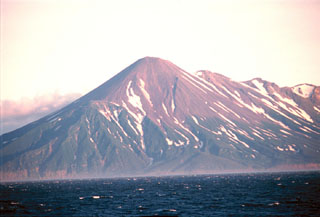
Chikurachki
Russia
50.324°N, 155.461°E; summit elev. 1781 m
All times are local (unless otherwise noted)
An explosive episode at Chikurachki occurred during 15-18 February 2015, the first eruption since the 29 July-8 August 2008 event (BGVN 33:08 and 41:06). The Kamchatka Volcanic Eruptions Response Team (KVERT) does not monitor the volcano with seismic instruments, but uses satellite monitoring and receives occasional visual observations. All dates and times are local (UTC + 12 hours).
According to KVERT, during 29-31 March 2016 a strong explosive eruption generated ash plumes that rose to a maximum altitude of 4 km and drifted 570 km NE, S, and SW. The initial activity was a gas-and-steam plume containing ash at 1240 on 29 March. At 1259 the Terra satellite imaged ash plumes that rose to an altitude of 3 km and drifted about 50 km NE. The Aviation Color Code (ACC) was raised to Orange (the second highest level on a four-color scale). An SO2 plume was identified in Aura/OMI data at 1400 (0200 UTC) on 30 March downwind SSE from the volcano (figure 11). This moderate activity continued into 1 April before subsiding. The ACC was lowered to Yellow on 2 April, and then to Green on 4 April.
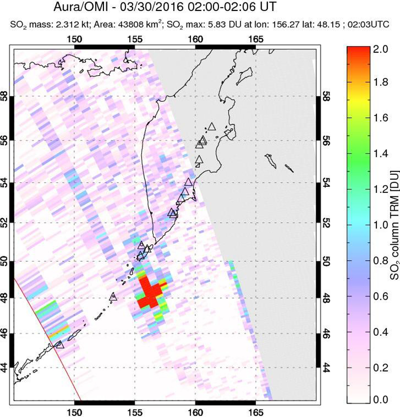 |
Figure 11. Sulfur dioxide plume drifting SSE detected using the Ozone Monitoring Instrument (OMI) on the Aura satellite, 30 March 2016. Estimated SO2 mass was 2.3 kt. Courtesy of NASA Goddard Space Flight Center. |
A new eruption began on 27 July 2016 at 1748 when an ash plume rose to an altitude of 4-5 km and drifted 176 km NE. Minor ashfall was reported in Severo-Kurilsk (Paramushir Island), about 61 km NE. The ACC was raised to Orange. A long detached plume of SO2 was identified in Aura/OMI data drifting NE of the volcano at 1311 (0111 UTC) on 28 July (figure 12). Heightened activity continued until 29 July local when activity subsided. The ACC was lowered to Yellow on 30 July and to Green by 3 August.
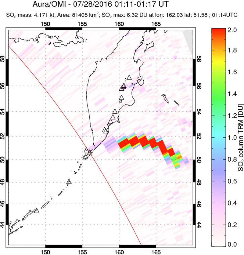 |
Figure 12. Sulfur dioxide plume drifting NE detected using the Ozone Monitoring Instrument (OMI) on the Aura satellite, 28 July 2016. Estimated SO2 mass was 4.2 kt. Courtesy of NASA Goddard Space Flight Center. |
Another moderate episode of activity began on 18 August 2016. KVERT reported that strong gas-steam emissions were visible during 1132-1700 on that date. Ash was visible in the plume beginning at 1720, prompting KVERT to raise the ACC to Orange. Gas-and-steam plumes containing ash rose as high as 4.5 km altitude and drifted 280 km NE. Minor ashfall was reported in Severo-Kurilsk. According to the Tokyo Volcanic Ash Advisory Center (VAAC), as cited by KVERT, ash was no longer detected in the plume starting at 2330 on 19 August. The ACC was lowered to Yellow on 19 August, and then to Green on 20 August.
Based on satellite observations, KVERT reported that on 29 August gas-and-steam plumes containing ash rose to an altitude of 2.5 km and drifted 35 km SE. The ACC was raised to Yellow. The next day, the volcano was quiet, although KVERT believes that moderate gas-and-steam activity probably continued. On 31 August the ACC was lowered to Green.
Thermal anomalies, based on MODIS satellite instruments analyzed using the MODVOLC algorithm, were not observed during the reporting period.
Geological Summary. Chikurachki, the highest volcano on Paramushir Island in the northern Kuriles, is a relatively small cone constructed on a high Pleistocene edifice. Oxidized basaltic-to-andesitic scoria deposits covering the upper part of the young cone give it a distinctive red color. Frequent basaltic Plinian eruptions have occurred during the Holocene. Lava flows have reached the sea and formed capes on the NW coast; several young lava flows are also present on the E flank beneath a scoria deposit. The Tatarinov group of six volcanic centers is located immediately to the south, and the Lomonosov cinder cone group, the source of an early Holocene lava flow that reached the saddle between it and Fuss Peak to the west, lies at the southern end of the N-S-trending Chikurachki-Tatarinov complex. In contrast to the frequently active Chikurachki, the Tatarinov centers are extensively modified by erosion and have a more complex structure. Tephrochronology gives evidence of an eruption around 1690 CE from Tatarinov, although its southern cone contains a sulfur-encrusted crater with fumaroles that were active along the margin of a crater lake until 1959.
Information Contacts: Kamchatka Volcanic Eruptions Response Team (KVERT), Far East Division, Russian Academy of Sciences, 9 Piip Blvd., Petropavlovsk-Kamchatsky, 683006, Russia (URL: http://www.kscnet.ru/ivs/); Tokyo Volcanic Ash Advisory Center (VAAC), Tokyo, Japan (URL: http://ds.data.jma.go.jp/svd/vaac/data/); OMI (Ozone Monitoring Instrument), Global Sulfur Dioxide Monitoring, Atmospheric Chemistry & Dynamics, NASA Goddard Space Flight Center, Goddard, Maryland, USA (URL: https://so2.gsfc.nasa.gov/); Hawai'i Institute of Geophysics and Planetology (HIGP), MODVOLC Thermal Alerts System, School of Ocean and Earth Science and Technology (SOEST), Univ. of Hawai'i, 2525 Correa Road, Honolulu, HI 96822, USA (URL: http://modis.higp.hawaii.edu/).