Report on Momotombo (Nicaragua) — January 2017
Bulletin of the Global Volcanism Network, vol. 42, no. 1 (January 2017)
Managing Editor: Edward Venzke.
Research and preparation by Paul Berger.
Momotombo (Nicaragua) Numerous explosions with ash plumes and lava flow, December 2015-April 2016
Please cite this report as:
Global Volcanism Program, 2017. Report on Momotombo (Nicaragua) (Venzke, E., ed.). Bulletin of the Global Volcanism Network, 42:1. Smithsonian Institution. https://doi.org/10.5479/si.GVP.BGVN201701-344090
Momotombo
Nicaragua
12.423°N, 86.539°W; summit elev. 1270 m
All times are local (unless otherwise noted)
Between 1996 and 2011 there were about 14 seismic swarms at Momotombo, along with fumarolic activity, and an explosion in 2006 (BGVN 37:02). According to the Instituto Nicaragüense de Estudios Territoriales (INETER), explosive activity that generated ash plumes resumed on 1 December 2015 and ended on 8 April 2016. The number of daily explosions increased beginning on 12 February 2016, with very high counts in the first half of March (figure 15).
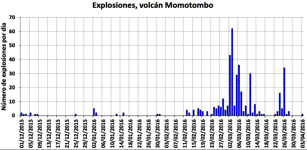 |
Figure 15. Histogram of number of daily explosions between 1 December 2015 and 3 April 2016. The total number of explosions with ash emissions was 409 (438 overall), with 314 reported in March 2016 alone (76 percent of total); 88 explosions were detected during 1 December 2015-1 March 2016. The graph does not show the few small explosions during the week subsequent to 3 April 2016. Courtesy of INETER. |
Activity during December 2015-January 2016. According to the Instituto Nicaragüense de Estudios Territoriales (INETER), an explosion at 0749 on 1 December 2015 generated a gas-and-ash plume that rose 1 km above the crater and drifted SW. Additional explosions at 0817, 0842, and 0855 generated ash plumes that rose 300 m. Gas emissions were visible the rest of the day. The Sistema Nacional para la Prevención, Mitigación y Atención de Desastres (SINAPRED) reported that during 1-2 December, explosions ejected incandescent tephra, and a slow-moving lava flow on the N flank was observed. According to a news report (La Prensa) that interviewed INETER officials, ashfall was reported in nearby communities to the W and SW, including La Concha (40 km SSE), Los Arcos, Flor de la Piedra, La Paz Centro, and Leóin. Some families in La Paz Centro (17 km SW) self-evacuated.
Based on satellite and webcam observations, and seismic data, the Washington Volcanic Ash Advisory Center (VAAC) reported that during 2-3 December 2015, ash plumes rose to an altitude of 2.4 km and drifted 90-225 km NW and WNW.
According to INETER and SINAPRED reports, activity continued through 10 December 2015. Fieldwork revealed a small, incandescent, circular crater halfway up the E flank that was fuming during the morning of 6 December. An explosion on 7 December destroyed part of the crater. On 10 December, SINAPRED reported that material had been accumulating in the crater since the beginning of the eruption on 1 December. Seismicity during 9-14 December was low and stable.
INETER reported that during 29-30 December 2015, no explosions were detected, though Real-time Seismic-Amplitude Measurements (RSAM) continued at moderate-to-high levels.
Three gas-and-ash explosions on 2 January 2016 (at 1333, 1426, and 1434) were noted in INETER and SINAPRED reports which excavated the remaining parts of the lava dome that had been emplaced about a month earlier. An ash plume rose 500 m above the crater, drifted S and SW, and caused ashfall in Puerto Momotombo (9 km WSW). Possible ash plumes from an explosion at 2129 were hidden by darkness. At 0420 on 3 January, an explosion ejected lava bombs 2 km away and caused ashfall in La Paz Centro. Lava flows had advanced as far as 2 km down the NE flank.
INETER reported that at 1209 on 12 January 2016, a large explosion ejected incandescent material onto the flanks and generated an ash plume that rose 4 km above the crater. Tephra was deposited on the E, NE, N, and NW flanks. Ash plumes drifted downwind and caused ashfall in the communities of Flor de Piedra, Amatistán, Guacucal (40 km N), La Palma, Puerto Momotombo (10 km WSW), La Sabaneta, Mira Lago, Asentamiento Miramar, Pancasán, René Linarte, Raúl Cabezas, and Betania. At around 0500 on 15 January, strong volcanic tremor was accompanied by small explosions in the crater; ejected ash and incandescent tephra were deposited on the W flank. Seismicity decreased during 16-17 January.
According to INETER, during 20-21 January both RSAM values and emissions were low. Volcanic tremor increased at 0900 on 22 January, causing RSAM values to rise to high levels. There were no emission changes. INETER recommended that the public stay at least 6 km away from the volcano.
INETER reported that during 26-29 January, RSAM values were at low to moderate levels, and gas emissions were at moderate levels. Crater incandescence from high-temperature gas emissions was observed at night during 26-27 January. A Strombolian explosion at 0344 on 30 January ejected tephra onto the E, NE, N, and NW flanks, and produced gas emissions. At 0529 on 31 January, another explosion also ejected gas, ash, and incandescent material. Ashfall was reported in the nearby communities of Boqueron, Puerto Momotombo, and La Sabaneta. Moderate levels of gas emissions drifted SW towards Puerto Momotombo.
Activity during February-April 2016. During 4-5 and 7-8 February, both RSAM values were low to moderate and emissions were at moderate levels. INETER reported moderate levels of gas emissions on 10 February; volcanic tremor and gas emissions increased to moderate-to-high levels the next day. An explosion on 12 February produced small ash emissions and ejected incandescent material onto the N and SE flanks. An explosion at 1305 on 15 February generated an ash plume that rose 2 km above the crater and ejected incandescent tephra onto the N and NE flanks.
INETER reported that during 16-17 February, two explosions accompanied by tremor produced ash emissions and ejected incandescent material onto the flanks. The first and largest explosion (at 0344) ejected incandescent tephra 800 m above the crater. RSAM values were at low-to-moderate levels. Based on webcam views and satellite images, the Washington VAAC reported that on 19 February, ash emissions rose to an altitude of 3.6 km and drifted SW and WSW. The next day, ash emissions drifted SW. On 21 February ash plumes drifted about 80 km W and 25 km E.
During 19 February-1 March, explosions were detected daily. Explosions produced ash plumes and ejected incandescent material onto the N, NE, E, and SE flanks. Ash plumes rose 1.7-2.3 km above the crater and drifted SW during 21-22 February; gas-and-ash plumes rose 1.8 km on 24 February; an ash plume rose 1 km on 25 February and a small gas-and-ash plume rose 300 m on 26 February. A pyroclastic flow traveled 3.5 km down the N and NW flanks during 23-24 February. Explosions on 27 February ejected tephra 300 m above the crater.
At 0646 on 1 March, explosions ejected gas and incandescent tephra, and an ash plume that rose 1.2 km lasted 16 minutes, causing the plume to widen and darken the sky. According to INETER, 53 small explosions during 2-3 March generated weak gas plumes that rose 300 m above the crater. On 3 March, some explosions produced ash plumes that drifted W and SW. RSAM values were at low to moderate levels. SINAPRED reported that during 5-6 March, there were 78 explosions for a total of 279 explosions detected since 1 December 2015. One of the most significant explosions occurred on 6 March. The next day gas-and-ash plumes rose as high as 1 km above the crater.
On 28 March, SINAPRED reported that 38 explosions, detected over a period of 24 hours, ejected gas-and-ash plumes and incandescent tephra. The strongest event occurred at 1140 on 27 March and generated a plume that rose 1 km.
SINAPRED reported that on 2 April, explosions produced gas-and-ash plumes and ejected incandescent tephra. According to INETER, three explosions during 5-6 April ejected incandescent material onto the flanks and produced gas-and-ash plumes that rose 500 m above the crater. During 6-7 April there were 27 small explosions. The explosions ejected some incandescent material and generated ash plumes that rose 200 m and drifted SW. RSAM values were low during 5-12 April.
Monthly INETER reports did not indicate any explosive activity after 8 April 2016. The August 2016 report indicated that seismicity was low, with only five volcano-tectonic earthquakes. The RSAM in August was a low 30 units.
Thermal anomalies during the 2015-16 eruption. Many thermal anomalies, based on MODIS satellite instruments analyzed using the MODVOLC algorithm, were observed between 2-6 December 2015, primarily on the ENE flank. Subsequently, one anomaly was observed on 1 February, 2 February, and 15 February 2016. A weak possible hotspot on the E flank was also observed on 19 February, but it was slightly S of the previous hotspots.
The Mirova (Middle InfraRed Observation of Volcanic Activity) system, also based on analysis of MODIS data, detected several anomalies within 5 km of the crater during March 2016, but none thereafter through 2016. The heat radiated by the volcanic activity (or Volcanic Radiative Power, as measured in watts) was mostly less than 0.5 watts.
Before this latest activity, a weak hotspot was also detected by MODVOLC on 7 March 2012 near the N rim of the crater, and on 19 June 2014, somewhat further down the E flank than most of the other events; neither event may have been associated with volcanism; no volcanic activity was reported on those days.
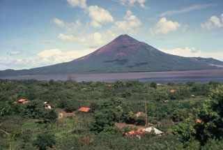
Geological Summary. Momotombo is a young stratovolcano that rises prominently above the NW shore of Lake Managua, forming one of Nicaragua's most familiar landmarks. Momotombo began growing about 4500 years ago at the SE end of the Marrabios Range and consists of a somma from an older edifice that is surmounted by a symmetrical younger cone with a 150 x 250 m wide summit crater. Young lava flows extend down the NW flank into the 4-km-wide Monte Galán caldera. The youthful cone of Momotombito forms an island offshore in Lake Managua. Momotombo has a long record of Strombolian eruptions, punctuated by occasional stronger explosive activity. The latest eruption, in 1905, produced a lava flow that traveled from the summit to the lower NE base. A small black plume was seen above the crater after a 10 April 1996 earthquake, but later observations noted no significant changes in the crater. A major geothermal field is located on the south flank.
Information Contacts: Instituto Nicaragüense de Estudios Territoriales (INETER), Apartado Postal 2110, Managua, Nicaragua (URL: http://webserver2.ineter.gob.ni/vol/dep-vol.html); Sistema Nacional para la Prevención, Mitigación y Atención de Desastres (SINAPRED), Edificio SINAPRED, Rotonda Comandante Hugo Chávez 50 metros al Norte, frente a la Avenida Bolívar, Managua, Nicaragua (URL: http://www.sinapred.gob.ni/); Washington Volcanic Ash Advisory Center (VAAC), Satellite Analysis Branch (SAB), NOAA/NESDIS OSPO, NOAA Science Center Room 401, 5200 Auth Rd, Camp Springs, MD 20746, USA (URL: http://www.ospo.noaa.gov/Products/atmosphere/vaac/, archive at: http://www.ssd.noaa.gov/VAAC/archive.html); Hawai'i Institute of Geophysics and Planetology (HIGP), MODVOLC Thermal Alerts System, School of Ocean and Earth Science and Technology (SOEST), Univ. of Hawai'i, 2525 Correa Road, Honolulu, HI 96822, USA (URL: http://modis.higp.hawaii.edu/); MIROVA (Middle InfraRed Observation of Volcanic Activity), a collaborative project between the Universities of Turin and Florence (Italy) supported by the Centre for Volcanic Risk of the Italian Civil Protection Department (URL: http://www.mirovaweb.it/); La Prensa (Nicaragua) (URL: http://www.laprensa.com.ni/).