Report on Manam (Papua New Guinea) — March 2017

Bulletin of the Global Volcanism Network, vol. 42, no. 3 (March 2017)
Managing Editor: Edward Venzke.
Edited by A. Elizabeth Crafford.
Manam (Papua New Guinea) Large ash plume to 19.8 km on 31 July 2015; persistent thermal anomalies during 2014-2016
Please cite this report as:
Global Volcanism Program, 2017. Report on Manam (Papua New Guinea) (Crafford, A.E., and Venzke, E., eds.). Bulletin of the Global Volcanism Network, 42:3. Smithsonian Institution. https://doi.org/10.5479/si.GVP.BGVN201703-251020
Manam
Papua New Guinea
4.08°S, 145.037°E; summit elev. 1807 m
All times are local (unless otherwise noted)
The remote island of Manam, 13 km off the northern coast of mainland Papua New Guinea is a basaltic-andesitic stratovolcano that has a 400-year history of recorded evidence for recurring low-level ash plumes and occasional Strombolian emissions, lava flows, pyroclastic avalanches, and large ash plumes. Pyroclastic flows and Strombolian activity during much of 2012 and 2013 were accompanied by numerous ash plumes rising a few kilometers above the summit (BGVN 38:06, 39:08). Activity between January 2014 and January 2017, described below, includes persistent thermal anomalies during most of this time, and a major ash plume rising to nearly 20 km altitude on 31 July 2015.
Monitoring is done by Papua New Guinea's Rabaul Volcano Observatory (RVO), part of the Department of Mineral Policy and Geohazards Management (DMPGM). This information is supplemented with aviation alerts from the Darwin Volcanic Ash Advisory Center (VAAC). MODIS thermal anomaly satellite data is recorded by the University of Hawai'i's MODVOLC thermal alert recording system, and the Italian MIROVA system.
MIROVA thermal anomaly data suggests Manam was intermittently active from at least late June 2014 through the end of the year. A single ash plume was reported on 6 September and two more were observed on 21 and 22 December. The appearance of MODVOLC thermal anomalies in late January 2015 that grew more frequent through April indicated increasing activity along with sporadic low-level ash plumes in late February and late April. Persistent levels of thermal anomalies and ash plume reports continued in May through early July.
On 31 July 2015 at about 1130 local time a large explosion sent an ash plume to nearly 20 km altitude, spreading volcanic blocks and ash over a wide area, and injuring two people. A second substantial ash plume rose to 6.4 km on 8 August. This was followed by three more small plumes in August, one in September, and two in October 2015 (on 8 and 29) before the volcano quieted down for a few months.
Thermal anomalies were present at the end of January 2016, and an ash plume was observed on 4 March 2016. New thermal anomalies intensified until June and then tapered off in early July. Persistent but more intermittent thermal anomalies continued throughout the year and were ongoing as of early January 2017.
Activity during 2014. Numerous explosions during 2013 tapered off at the end of the year, with the last ash emissions reported on 15 December 2013. In January 2014, RSAM values were lower but still fluctuating above background levels. A report from RVO in early April noted that both summit craters remained quiet through March 2014, with no audible noises or incandescence visible at night. The seismicity remained within background levels of 160-180 RSAM and daily volcanic event counts ranged from 830 to 920. Tiltmeter data showed no significant short-term changes, but over the previous three months there was a gradual inflationary trend towards the summit area. The Alert Level was lowered to Stage 1.
A thermal anomaly appears at the very end of June 2014 in the first available MIROVA LRP data (figure 30). This is followed by additional thermal anomalies in August, October, and November. The Darwin VAAC reported a small ash plume on 6 September 2014 that rose to 2.1 km altitude (300 m above the summit) and drifted 37 km NW. It was visible on infrared satellite imagery for a few hours before dissipating. In their report for October 2014, RVO noted that Manam remained quiet for the month with no audible noises or incandescence; seismicity remained at low to moderate levels, and daily volcanic-event counts ranged between 860 and 920. They also observed that the long-term inflationary trend at the summit observed since the beginning of 2014 continued. Small amounts of white-gray ash drifting SE were reported by RVO on 21 and 22 December from the Southern Crater, with a plume height of only 200 m. They also noted continued E-W inflation.
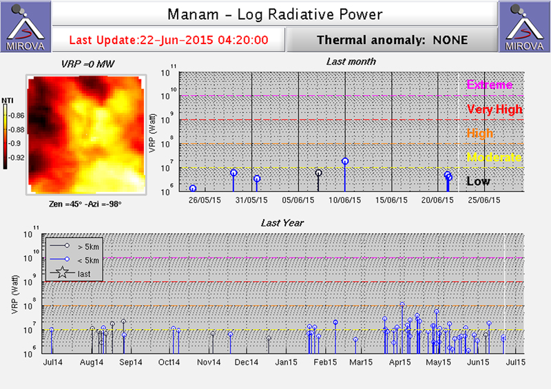 |
Figure 30. MIROVA Log VRP data for Manam from 22 June 2014 through 22 June 2015. Intermittent thermal anomalies are recorded at the end of June, early and late August, early October, and mid-November 2014. Thermal activity increased in frequency and intensity starting in the second half of January 2015. Courtesy of MIROVA. |
Activity during 2015. RVO noted incandescence from the Main Crater beginning on 19 January 2015, growing stronger during the last week of the month, matching observations in the MIROVA data (figure 30). A MODVOLC thermal alert pixel appeared on 23 January. Seismicity also changed after the middle of the month when RSAM values rose above 200 on 16 January and went as high as 500 on 31 January, after which they declined rapidly and remained low during February.
In February 2015, seismicity was characterized by small to moderate sub-continuous and continuous volcanic tremors. Increased incandescence was also evident from the Main Crater during February. RVO reported weak-to-bright steady incandescence during 7-10, 21, and 26 February. MODVOLC captured two thermal alert pixels on 8 February, and MIROVA reported an anomaly at the end of the first week and during the last week of the month. An ash plume was observed in satellite data by the Darwin VAAC on 24 February; the plume rose to 3 km altitude (1.2 km above the summit) and drifted 37 km W. RSAM values rising to 500 by 18 March led RVO to raise the Alert Level that day to Stage 2. Visual observations were difficult due to weather during much of the month, but MODVOLC reported thermal alert pixels on 19 and 26 March, and MIROVA captured several anomalies at the beginning of a period of increased frequency and intensity of thermal anomalies that lasted through mid-June (figure 30).
RVO reported that during April 2015 both craters released variable amounts of white vapor. Clearer skies revealed incandescence from the Southern Crater during nine nights of the month and seven times from the Main Crater. This is consistent with satellite thermal anomaly observations by MODVOLC on six different days, with four of them being multiple pixel alerts, and numerous anomalies captured by MIROVA. Two ash eruptions were reported by the Darwin VAAC on 27 and 30 April. The first low-level plume rose to 2.4 km and was observed in satellite imagery extending over 100 km to the W before dissipating on 28 April. The second plume was observed at the same altitude drifting 150 km NW. Seismicity remained high during April, still characterized by discreet small to moderate low-frequency earthquakes, and RSAM values ranged between 300 and 650, increasing during the month. Ground deformation GPS measurements at the end of April confirmed the continuing inflationary trend recorded by the electronic tiltmeters since the last measurements taken in May 2013 (figure 31).
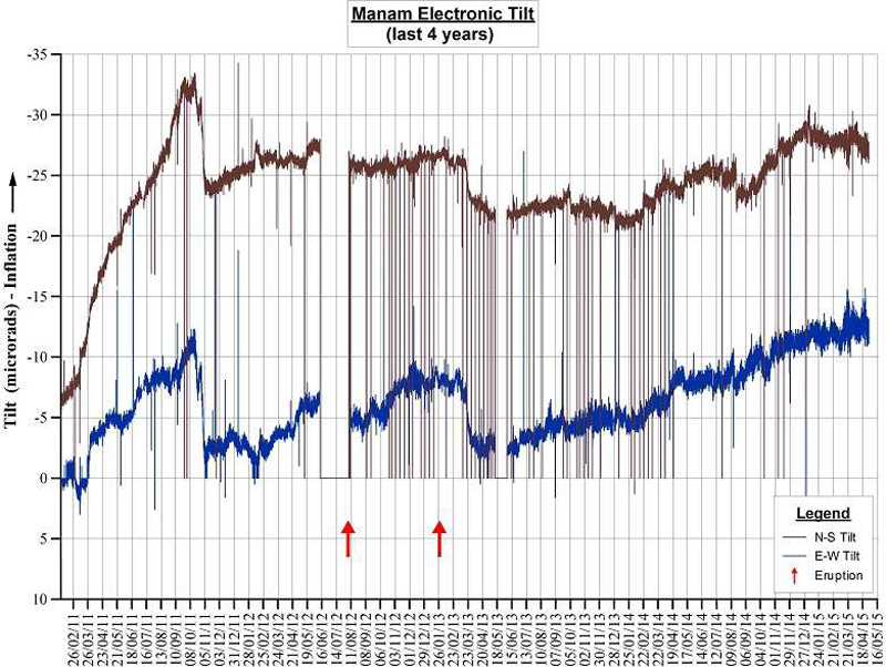 |
Figure 31. Electronic tilt measurements at Manam between 26 February 2011 and 1 May 2015 show a continuing inflationary trend. Eruptions in August 2012 and January 2013 are shown by red arrows. Courtesy of RVO (Volcano Information Bulletin 01-042015, 4 May 2015). |
Multiple sources of satellite data confirmed that Manam was active during May 2015. MODVOLC thermal alert pixels were reported from MODIS data captured on 6 and 22 May; MIROVA thermal anomalies were frequent. Ash plumes were reported from visible satellite imagery by the Darwin VAAC on 13 May at 3 km altitude drifting 37 km NE; SO2 plumes were captured by NASA's OMI instrument on the Aura satellite on 2, 12, 13, and 20 May (figure 32).
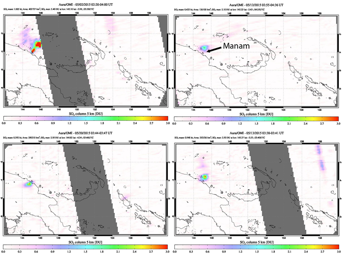 |
Figure 32. SO2 plumes captured by NASA's OMI instrument on the Aura satellite for Manam during May 2015. Clockwise from top left: 2 May, 12 May, 13 May, and 20 May. Missing data (gray stripes) are due to OMI row anomaly. Courtesy of NASA/GSFC. |
During June and early July 2015 there were four series of Volcanic Ash advisory reports from the Darwin VAAC. The first, on 21 and 22 June, reported a 3-km-altitude ash plume that extended over 35 km N and NW. The second, from 28 to 30 June, had altitudes that started at 2.4 and rose to 3 km, and drifted 75 km NE. A third plume emerged late on 30 June and lasted through 1 July, drifting 130 km E at 2.4 km altitude. A fourth plume reported on 2 July was confirmed by RVO as only a steam plume with no ash, and was seen in satellite imagery drifting 45 km E at 2.4 km altitude. A single MODVOLC thermal alert pixel was recorded on 7 July.
RVO reported a significant eruption on 31 July 2015 from the Southern Crater beginning about 1130 local time. They observed that low roaring noises marked the onset of the explosion followed by continuous ejection of scoria until about 1330. Fist-sized volcanic debris was reported at Warisi village on the E side of the island. At Baliau on the N side, clasts were about 10-20 cm in diameter. Two people were reportedly knocked unconscious from the falling scoria. Strong emissions of dark gray ash clouds followed the ejection of scoria and continued into the early afternoon. By 1740 emissions consisted of light gray ash clouds. The news source One Papua New Guinea reported that fine ash began to fall over Bogia (25 km SW on the mainland) around 1245 local time.
The ash plume was initially observed in satellite imagery by the Darwin VAAC at 19.8 km altitude spreading out in all direction for 100 km. It was captured by the Japanese Himawari-8 satellite (figure 33); an animation of the imagery showing the eruption was provided by Miller et al. (2016). Four hours later, the plume was visible 370 km to the SW. A lower-altitude ash plume at 6.7 km was observed the next day extending over 100 km SW. A significant SO2 plume was partially captured by the Aura instrument on the OMI satellite the next day, and measured an SO2 mass of 3.206 kilotons.
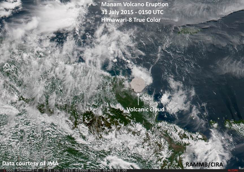 |
Figure 33. Ash cloud from Manam captured with True Color imagery by the Himawari-8 satellite on 31 July 2015 at 1150 local time, showing ash dispersing in all directions shortly after the explosion. Data courtesy of JMA (Japan Meteorological Agency), annotated image courtesy of RAMMB/CIRA (in Q4 report for 2015). An animation of the imagery showing the eruption is provided by Miller et al. (2016). |
The Darwin VAAC reported a new small ash plume on 6 August 2015 rising to 2.7 km drifting around 40 km to the NW, and another large ash plume on 8 August that initially rose to 6.4 km and drifted SSW. Pilots reported the ash at 5.8 km altitude about 90 km W of Kiunga Airport which is located 475 km SW of Manam. About 24 hours later, pilots reported another ash plume at 6 km altitude 150 km SE of the volcano. A hot spot was observed at the summit on 9 August; two MODVOLC thermal alert pixels appeared that day, and another one appeared on 15 August. A small plume was reported on 21 August, only rising to 2.1 km and drifting about 8 km ESE. This was followed two hours later by an ash plume observed 16 km NW at the same altitude, which continued to drift NW to 75 km before dissipating. Additional ash plumes were reported from 26-28 August rising to 2.4 km and drifting from 35 to 75 km, first NE, then N and NW; a small plume was reported on 31 August at 2.1 km drifting 75 km N before dissipating that day.
A single MODVOLC thermal alert pixel on 4 September was the last recorded in 2015. The next plume on 7 September was small, rising only to 2.1 km and drifting 75 km NW, briefly observed in one satellite before dissipating. It was a month until the next ash plume on 8 October 2015, when Darwin VAAC made a satellite observation of a plume at 1.8 km drifting 45 km NW. The last ash plume of 2015 was captured in satellite images on 29 October between 2.1 and 2.4 km altitude around 35 km NW.
Activity during 2016. The MIROVA data recorded thermal activity on about 29 January 2016 that increased in intensity and frequency in early March (figure 34). A small ash plume on 4 March rose to 3 km altitude and drifted about 90 km SE according to the Darwin VAAC. Increased thermal activity was recorded in MODVOLC thermal alert pixels and MIROVA data from early March through mid-July. There were no reports from the RVO during this time. The first MODVOLC alert was recorded on 7 March and they were persistent, almost every week, through the second week of July. On 13 July, an ash plume was observed by the Darwin VAAC in satellite imagery at 3 km altitude drifting 55 km W for a few hours before dissipating. After that, single-pixel MODVOLC thermal alerts were recorded on 20 September and 6 October. The MIROVA analysis of the MODIS data records a similar picture with a clear increase in the frequency and intensity of anomalies between early March and mid-July (figure 34); continuing pulses of thermal anomalies are present every month into January 2017.
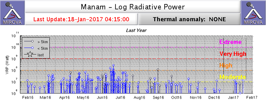 |
Figure 34. Log Radiative Power from MODIS thermal anomaly data recorded by MIROVA for Manam between 19 January 2016 and 18 January 2017. The increased frequency and intensity of thermal anomalies between early March and mid-July agrees well with other indicators of volcanic activity. Additionally, the MIROVA data suggests continued intermittent activity through 18 January 2017. Courtesy of MIROVA. |
Reference: Miller S D, Schmit T L, Seaman C J, Lindsey D T, Gunshor M M, Kohrs R A, Sumida Y, Hillger D, 2016, A Sight for Sore Eyes: The Return of True Color to Geostationary Satellites, Bulletin of the American Meteorological Society, vol. 97, no. 10. DOI: http://dx.doi.org/10.1175/BAMS-D-15-00154.1. Animated imagery of the 31 July 2015 eruption can be viewed at http://journals.ametsoc.org/doi/suppl/10.1175/BAMS-D-15-00154.1/suppl_file/10.1175_BAMS-D-15-00154.2.html .
Geological Summary. The 10-km-wide island of Manam, lying 13 km off the northern coast of mainland Papua New Guinea, is one of the country's most active volcanoes. Four large radial valleys extend from the unvegetated summit of the conical basaltic-andesitic stratovolcano to its lower flanks. These valleys channel lava flows and pyroclastic avalanches that have sometimes reached the coast. Five small satellitic centers are located near the island's shoreline on the northern, southern, and western sides. Two summit craters are present; both are active, although most observed eruptions have originated from the southern crater, concentrating eruptive products during much of the past century into the SE valley. Frequent eruptions, typically of mild-to-moderate scale, have been recorded since 1616. Occasional larger eruptions have produced pyroclastic flows and lava flows that reached flat-lying coastal areas and entered the sea, sometimes impacting populated areas.
Information Contacts: Rabaul Volcano Observatory (RVO), Geohazards Management Division, Department of Mineral Policy and Geohazards Management (DMPGM), PO Box 3386, Kokopo, East New Britain Province, Papua New Guinea; Darwin Volcanic Ash Advisory Centre (VAAC), Bureau of Meteorology, Northern Territory Regional Office, PO Box 40050, Casuarina, NT 0811, Australia (URL: http://www.bom.gov.au/info/vaac/); Hawai'i Institute of Geophysics and Planetology (HIGP), MODVOLC Thermal Alerts System, School of Ocean and Earth Science and Technology (SOEST), Univ. of Hawai'i, 2525 Correa Road, Honolulu, HI 96822, USA (URL: http://modis.higp.hawaii.edu/, http://modis.higp.hawaii.edu/); MIROVA (Middle InfraRed Observation of Volcanic Activity), a collaborative project between the Universities of Turin and Florence (Italy) supported by the Centre for Volcanic Risk of the Italian Civil Protection Department (URL: http://www.mirovaweb.it/); NASA Goddard Space Flight Center (NASA/GSFC), Global Sulfur Dioxide Monitoring Page, Atmospheric Chemistry and Dynamics Laboratory, Goddard, Maryland, USA (URL: https://so2.gsfc.nasa.gov/); Regional and Mesoscale Meteorology Branch (RAMMB) / Cooperative Institute for Research in the Atmosphere (CIRA), NOAA/NESDIS, Colorado State University, Fort Collins, CO 80523-1375, USA (URL: http://rammb.cira.colostate.edu/); One Papua New Guinea (URL: http://www.onepng.com/2015/07/manam-volcano-erupts.html).