Report on Kavachi (Solomon Islands) — March 2017
Bulletin of the Global Volcanism Network, vol. 42, no. 3 (March 2017)
Managing Editor: Edward Venzke.
Research and preparation by Robert Andrews.
Kavachi (Solomon Islands) Evidence of regular explosive activity during 2006-2016 from satellite and direct observations
Please cite this report as:
Global Volcanism Program, 2017. Report on Kavachi (Solomon Islands) (Venzke, E., ed.). Bulletin of the Global Volcanism Network, 42:3. Smithsonian Institution. https://doi.org/10.5479/si.GVP.BGVN201703-255060
Kavachi
Solomon Islands
8.991°S, 157.979°E; summit elev. -20 m
All times are local (unless otherwise noted)
The submarine Kavachi volcano in the Solomon Islands south of Gatokae and Vangunu islands is frequently active but rarely observed. Consistent activity was reported for more than 4 years between November 1999 and August 2003. An 8-month period of quiet was broken with another explosive eruption above the ocean surface on 15 March 2004 (BGVN 30:03). No observations of ongoing activity are known over the next two years, though eruptions may have continued. Satellite imagery using the Advanced Spaceborne Thermal Emission and Reflection Radiometer (ASTER) during 2006-2016 frequently revealed evidence of activity, on at least 35 days, using the Visible Near Infrared (VNIR) bands. Very little ASTER imagery is available for Kavachi during 2001-2005.
ASTER images on 27 February and 24 March 2006 (figure 13) show renewed activity. Vigorous upwelling along with turbulent ash-laden water and a sulfur odor was witnessed on 6 April 2007 (BGVN 32:07). An ASTER image on 15 June 2007 (figure 14) showed pulses of discolored water originating from the vent, confirming ongoing activity. A small area of discolored water was next seen in satellite imagery on 12 December 2007. A small plume of discolored water appeared in ASTER imagery again on 26 February 2008. On 20 March 2008 the Landsat 7 Enhanced Thematic Mapper captured an image of an ash-and-steam eruption plume extending about 25 km NNE towards Gatokae (figure 15). The next satellite evidence of discolored water plumes were on 7 October 2008.
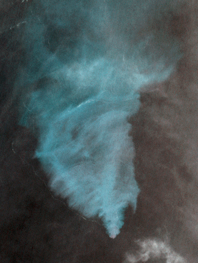 |
Figure 13. ASTER VNIR satellite image showing a submarine plume of discolored water originating above the summit of Kavachi, 24 March 2006. There appears to be turbulence at the ocean surface and a possible line of pumice along the lower left edge of the discolored area. Courtesy NASA/METI/AIST/Japan Spacesystems, and U.S./Japan ASTER Science Team, ASTER via the Image Database for Volcanoes. |
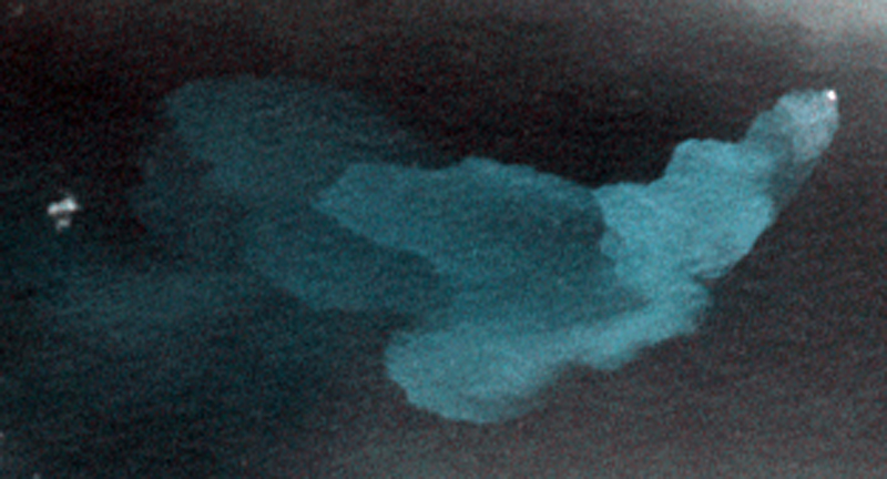 |
Figure 14. ASTER VNIR satellite image showing a submarine plume of discolored water originating above the summit of Kavachi, 15 June 2007. Distinct pulses of activity, possibly individual explosions at the bright surface origin spot, can be identified based on the increasing diffusion of suspended particulates with distance from the source. Courtesy NASA/METI/AIST/Japan Spacesystems, and U.S./Japan ASTER Science Team, ASTER via the Image Database for Volcanoes. |
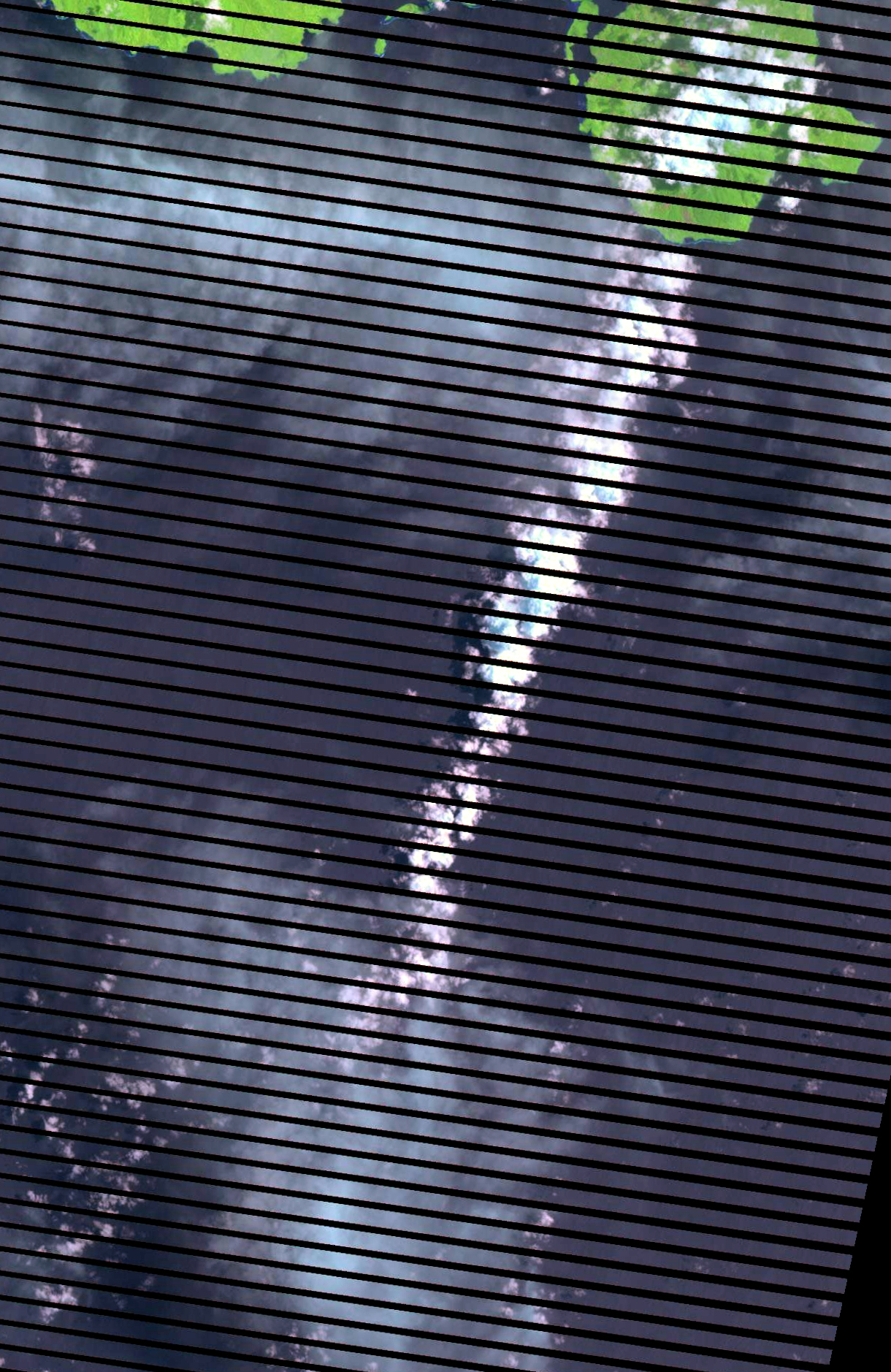 |
Figure 15. Satellite image showing an eruption plume from Kavachi on 20 March 2008 taken using the Enhanced Thematic Mapper on Landsat 7. Image modified using the "Percent Clip" option. Courtesy of USGS LandsatLook Viewer. |
An image on 11 November 2009 showed a larger very bright spot above the summit, possibly indicating turbulent activity at the ocean surface. Evidence of activity became more frequent in 2010, with imagery showing plumes on 15 February, 19 March, 23 June, 11 September, and 30 November. Submarine plumes continued to be visible often in ASTER images the following year, on 1 January, 13 March, 9 May, and 16 October 2011. The next available satellite image with a discolored submarine plume from Kavachi was on 9 April 2012. Additional plumes were seen on 16 April, 3 June (figure 16), 31 August, and 26 November 2012.
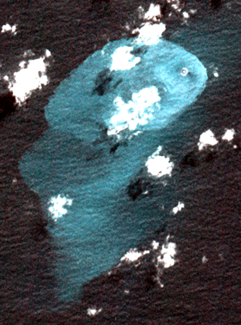 |
Figure 16. ASTER VNIR satellite image showing a submarine plume of discolored water originating above the summit of Kavachi, 3 June 2012. There appears to be a small island or area of persistent ash-laden surface turbulence at the source of the plume. Courtesy NASA/METI/AIST/Japan Spacesystems, and U.S./Japan ASTER Science Team, ASTER via the Image Database for Volcanoes. |
Intermittent satellite evidence of ongoing activity continued in 2013 with a discolored water plumes on 28 April, 15 June, 8 July, 25 August, 10 September, and 8 December. On 24 September 2013, Brennan Phillips of the University of Rhode Island passed within 2 km of the main peak onboard the M/Y Alucia but "did not see any visual eruptive activity on the surface."
Although the imagery is not conclusive, many of the ASTER images after 3 June 2012 appeared to show a small island. On 9 January 2014 the ASTER imagery was much clearer, providing greater visual evidence that eruptive activity had built a small island from which discolored water plumes were emanating (figure 17). A few weeks later, on 29 January, the Earth Observing 1 (EO1) Advanced Land Imager (ALI) obtained an image of a submarine plume (BGVN 39:07) and turbulent source area similar to those seen in ASTER imagery. Additional activity was in evidence on 21 March and 8 May.
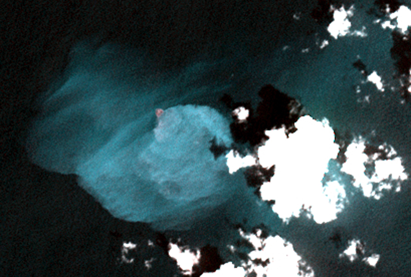 |
Figure 17. ASTER VNIR satellite image showing a submarine plume of discolored water originating above the summit of Kavachi, 9 January 2014. A distinct small island or area of persistent ash-laden surface turbulence can be readily identified at the source of the plume. Courtesy NASA/METI/AIST/Japan Spacesystems, and U.S./Japan ASTER Science Team, ASTER via the Image Database for Volcanoes. |
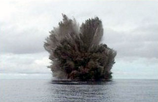
A cruise ship operated by EYOS Expeditions reported an eruption "at least four times" on 10 June 2014 (figure 18). The Expeditions' website noted that a staff member "spotted on the horizon discolored water and disturbances on the surface. As the vessel approached closer a few large plumes of water broke the surface about once every 10 minutes. Just before the ship left, however, [the] sea seemed to erupt and a massive plume of water and ash shot high into the air…." The island, or possibly an eruption exhibiting turbulence with abundant ash at the surface, appeared again on a 9 November 2014 image, and submarine plumes were evident in an 11 December 2014 image.
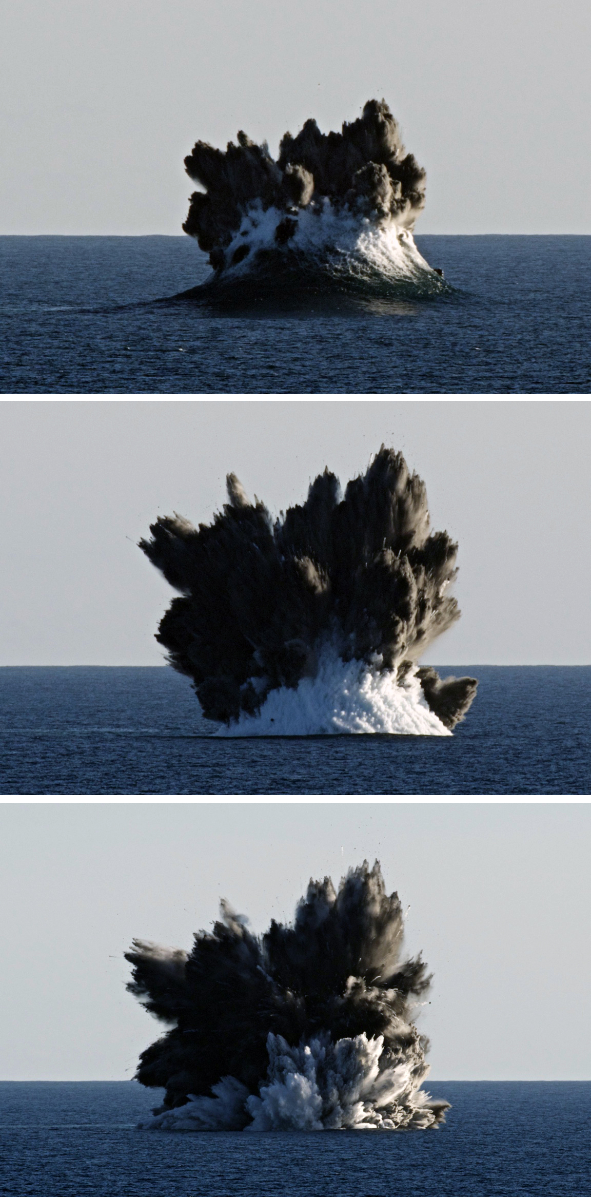 |
Figure 18. Photo of an eruption sequence from Kavachi on 10 June 2014 taken from a cruise ship. Courtesy of EYOS Expeditions. |
An expedition for National Geographic in January 2015 took place during a rare lull in volcanic activity that enabled access to the volcano for mapping and sampling. B. Phillips reported that no eruptive activity was seen while at the summit location on 12-14 and 18 January 2015, but there was a large surface plume and lots of off-gassing from the crater rim; ASTER imagery confirmed a plume of discolored water on 12 January. Autonomous cameras deployed directly into the crater observed sharks, reef fish, and what appear to larvaceans (National Geographic, 2015).
Satellite imagery showed discolored submarine plumes on 18 October 2015, but then not again until 26 August 2016. Eruptions were witnessed on a second visit by B. Phillips for National Geographic during 31 October-1 November 2016 (see National Geographic, 2017). Activity consisted of phreato-magmatic explosions approximately every 7 minutes that sent steam, ash, and incandescent tephra up to 50 m above the ocean surface. There was an occasional larger eruption roughly every hour. A remotely operated surface "drone" with a GoPro camera was right at the edge of the explosion but remained functional. Small lava particles stuck to the PVC hull of the vehicle itself were recovered and given to the Marine Geological Samples Laboratory (MGSL) of the Graduate School of Oceanography (GSO), University of Rhode Island."
Bathymetric survey. A paper by Phillips and others (2016) following the January 2015 visit included medium-resolution bathymetry of the main peak (figure 19), along with benthic imagery, biological observations, petrological and geochemical analysis of samples from the crater rim, measurement of water temperature and gas flux over the summit, and descriptions of the hydrothermal plume structure. Based on the bathymetry, the summit was described by Phillips and others (2016) as being oblong with a pockmarked crater measuring approximately 75 x 120 m, and a rim rising to an average of 24 m depth. The deepest soundings on the peak were about 70 m and indicated asymmetrical terrain surrounded by almost uniform flanks with 18° slopes that descend to depths greater than 1,000 m. They confirmed the existence of a "southwest extension," or secondary summit rising to 260 m depth 1.3 km SW of the main summit.
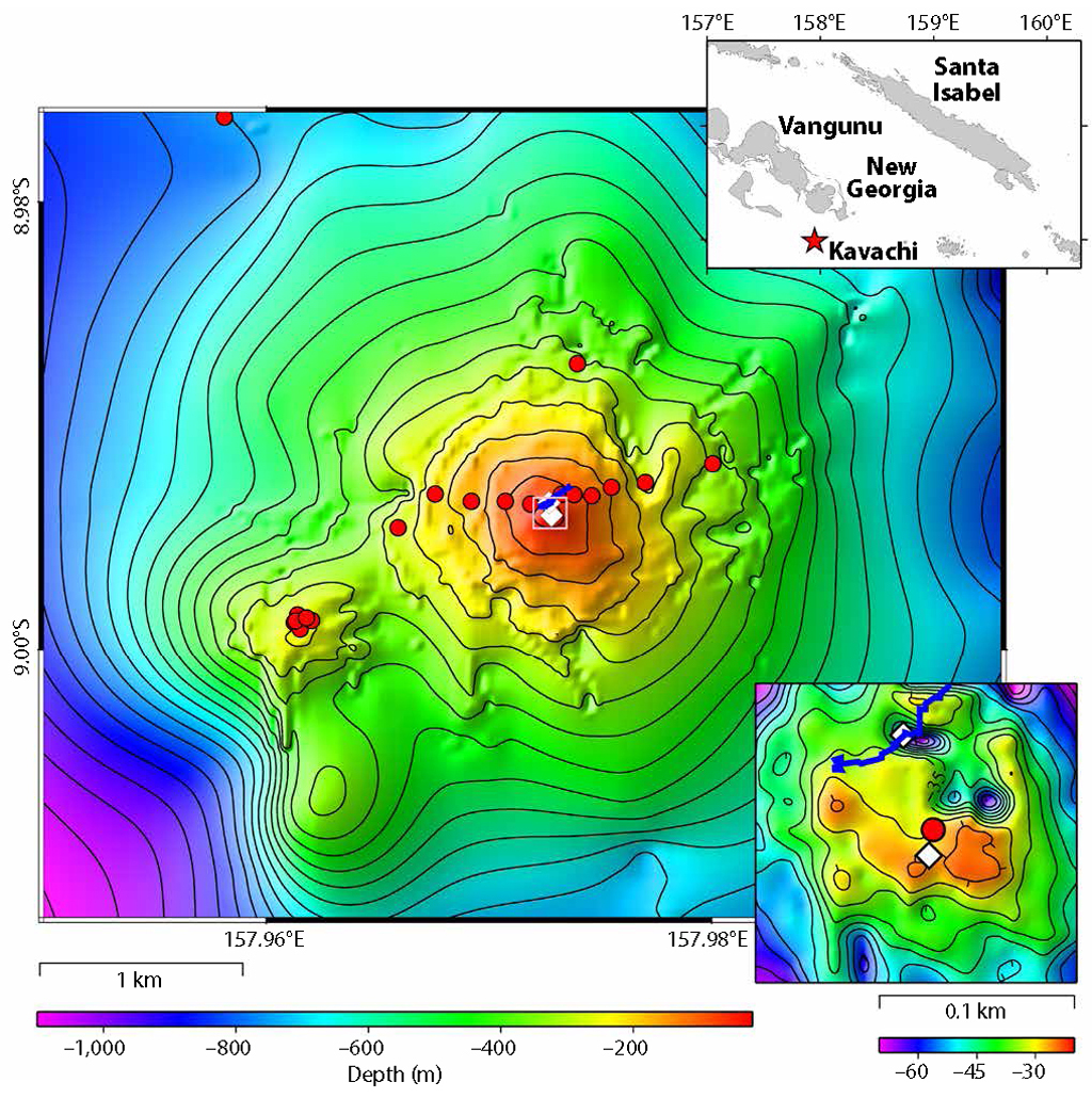 |
Figure 19. Bathymetry of Kavachi submarine volcano and the summit crater (inset, lower right). Red circles indicate locations of water column profiles and benthic imagery. White diamonds locate baited drop cameras deployments. The blue line delineates the path of a surface drifter that measured temperature and atmospheric CO2, The contour map and the inset at lower right were created from approximately 85,000 depth soundings visualized and edited as a three-dimensional point-cloud using IVS Fledermaus. The location map (upper right) was created with Generic Mapping Tools (v 4.5) using data available from Marine Geoscience Data System's Global Multi-Resolution Topography Data Synthesis (v 3.1). From Philips and others (2016). |
References: National Geographic, 2015, Sharks discovered inside underwater volcano (exclusive video) (URL: http://video.nationalgeographic.com/video/expedition-raw/150708-sciex-exraw-sharks-underwater-volcano; https://www.youtube.com/watch?v=0e3t18rrjOA).
National Geographic, 2017, Robot vs. Volcano: "Sometimes It's Just Fun to Blow Stuff Up" (exclusive) (URL: http://video.nationalgeographic.com/video/expedition-raw/170419-sciex-exraw-robot-vs-volcano-sometimes-just-fun-to-blow-stuff-up; https://www.youtube.com/watch?v=Ca0zAAIVK3E).
Phillips, B.T., Dunbabin, M., Henning, B., Howell, C., DeCiccio, A., Flinders, A., Kelley, K.A., Scott, J.J., Albert, S., Carey, S., Tsadok, R., and Grinham, A., 2016. Exploring the "Sharkcano": Biogeochemical observations of the Kavachi submarine volcano (Solomon Islands), Oceanography v. 29(4), p. 160-169 (https://doi.org/10.5670/oceanog.2016.85).
Geological Summary. Named for a sea-god of the Gatokae and Vangunu peoples, Kavachi is located in the Solomon Islands south of Vangunu Island. Sometimes referred to as Rejo te Kvachi ("Kavachi's Oven"), this shallow submarine basaltic-to-andesitic volcano has produced ephemeral islands up to 1 km long many times since its first recorded eruption during 1939. Residents of the nearby islands of Vanguna and Nggatokae (Gatokae) reported "fire on the water" prior to 1939, a possible reference to earlier eruptions. The roughly conical edifice rises from water depths of 1.1-1.2 km on the north and greater depths to the SE. Frequent shallow submarine and occasional subaerial eruptions produce phreatomagmatic explosions that eject steam, ash, and incandescent bombs. On a number of occasions lava flows were observed on the ephemeral islands.
Information Contacts: EYOS Expeditions, Knox House, 16-18 Finch Rd, Douglas, Isle of Man, IM1 2PT (URL: http://www.eyos-expeditions.com/2014/07/kavachi-volcano/, https://my.yb.tl/eyosexpeditions/1604/); Brennan Phillips, Harvard University, Wyss Institute for Biologically Inspired Engineering, Wood Lab, 60 Oxford St., Cambridge, MA 02138 USA; Image Database for Volcanoes, Geological Survey of Japan, National Institute of Advanced Industrial Science and Technology (AIST) (URL: https://gbank.gsj.jp/vsidb/image/index-E.html, https://gbank.gsj.jp/vsidb/image/Kavachi/aster_p1.html); USGS LandsatLook Viewer (URL: https://landsatlook.usgs.gov/).