Report on Soputan (Indonesia) — March 2017

Bulletin of the Global Volcanism Network, vol. 42, no. 3 (March 2017)
Managing Editor: Edward Venzke.
Edited by A. Elizabeth Crafford.
Soputan (Indonesia) Ash plumes to over 12 km altitude, lava flows, pyroclastic flows, and Strombolian activity during January-February 2016
Please cite this report as:
Global Volcanism Program, 2017. Report on Soputan (Indonesia) (Crafford, A.E., and Venzke, E., eds.). Bulletin of the Global Volcanism Network, 42:3. Smithsonian Institution. https://doi.org/10.5479/si.GVP.BGVN201703-266030
Soputan
Indonesia
1.112°N, 124.737°E; summit elev. 1785 m
All times are local (unless otherwise noted)
Soputan stratovolcano on the northern tip of Indonesia's island of Sulawesi has had historically observed eruptions since the 18th century, possibly earlier. The locus of eruptions has included both the summit crater and a NE-flank vent that was active during 1906-1924. Since the 1980's, continuing lava-dome growth has been punctuated by ash explosions, lava flows, and Strombolian eruptions every few years. When these events last occurred between January and March 2015, they were accompanied by strong thermal anomalies and elevated seismicity which continued into early July 2015 (BGVN 41:05). This report covers the period from July 2015 through September 2016.
Increased seismicity in November 2015 signaled the beginning of a new eruptive episode, with explosions in January and February 2016. Soputan is monitored by PVMBG (Pusat Vulkanologi dan Mitigasi Bencana Geologi), Badan Nasional Penanggulangan Bencana (BNPB) which is the Indonesian National Disaster Management Agency, and aviation alerts are managed by the Darwin VAAC (Volcanic Ash Advisory Center). Information is also provided by the University of Hawaii's MODVOLC Thermal Alert System and the MIROVA project, an Italian collaboration; both groups analyze the MODIS satellite data for thermal anomalies related to volcanoes.
Soputan erupted a significant ash plume to over 12 km altitude on 4 January 2016 after a few months of increasing seismicity. Lava flows, Strombolian eruptions, and a pyroclastic flow were observed the next day. Another large ash plume to 13 km altitude occurred on 14 January. A series of explosions beginning on 6 February resulted in more ash plumes, lava flows, and Strombolian eruptions for about 24 hours, after which activity decreased significantly. Several villages within 20 km reported ashfall from these events. The last reported activity was on 7 February 2016, although thermal anomaly data extended well into April. Seismicity had declined significantly by mid-April when the Alert Level was lowered.
Activity during July-November 2015. PVMBG lowered the Alert Level to II (second lowest on a four-level scale) on 3 July 2015, citing reduced harmonic tremor and stable RSAM (Real-time Seismic amplitude measurements) at background levels compared with the eruptive activity between January and March 2015. They did not issue another update until 3 November 2015.
MODVOLC thermal alert information from MODIS (Moderate Resolution Imaging Spectroradiometer) satellite data indicated anomalies in the vicinity of Soputan twice in September and four times in October 2015, but the locations were far enough from the volcano to suggest that they were not related to volcanic activity. This is corroborated with the MIROVA (Middle InfraRed Observation of Volcanic Activity) data from this same period which also recorded increases in Volcanic Radiative Power (VRP) in September and October. The locations indicated by MIROVA are mostly greater than 5 km from the summit, also suggesting a non-volcanic source (figure 12).
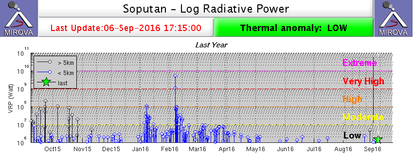 |
Figure 12. MIROVA analysis of MODIS data for 6 September 2015 through 6 September 2016 for Soputan. Moderate to High values in September and October 2015 are noted in black, indicating sources more than 5 km from the volcano and likely not related to eruptive activity. Low values in blue between 6 September and mid-December are from an unknown source within 5 km of the summit. The spikes on 4-6 January 2016 and 6-8 February correspond to observed ash plumes, lava flows, pyroclastic flows, and Strombolian eruptions reported by PVMBG. Courtesy of MIROVA. |
Additional thermal anomaly signals in the MIROVA data from mid-September through early December 2015 appear to be sourced within 5 km of the summit (figure 12), but their origin is unknown. PVMBG makes no mention of active eruptions or ash plumes during this time. PVMBG maintained the Level II alert status and documented clear skies with diffuse white steam plumes rising between 20 and 200 m from the summit crater during the last half of October and November, unchanged since July. They noted, however, that the frequency of several types of earthquakes began a gradual increase in the middle of October.
Activity during January-September 2016. Elevated seismicity continued until 4 January 2016. Photos taken on 3 and 4 January showed an increase in the density of the white-to-light-gray emissions rising to 300 m above the summit (figure 13).
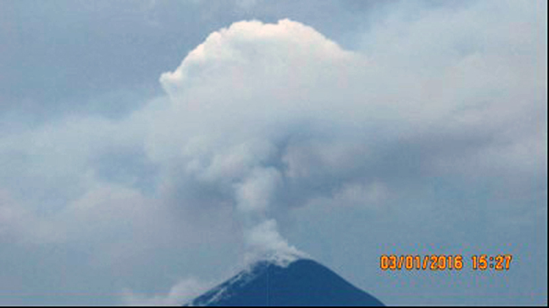 |
Figure 13. Emissions (white to light-gray) rise from Soputan on 3 January 2016, about 24 hours prior to a significant ash eruption (colors adjusted from original image). Courtesy of PVMBG (Soputan activity report through 4 January 2016). |
Dense reddish-white emissions rose 300 m above the summit early in the day on 4 January. A thermal image taken that day indicated that lava was present at the summit; PVMBG raised the Alert Level to III. Seismic amplitude (RSAM) values had also increased sharply in the preceding 12 hours, and tilt measurement data indicated significant inflation of the volcano. BNPB reported an ash eruption at 2053 local time, with a plume rising 2 km from the summit and drifting SE, and incandescent lava flowing down the E flank. Minor ashfall was reported in Langowan (12 km NE) in the Minahasa District. The Darwin VAAC raised the Aviation Color Code (ACC) to Red at 2230 local time and reported an ash plume at 12.8 km altitude drifting west 30 minutes later. This was followed in the next 24 hours by two more plumes that rose to 10.6 km and drifted NW to NE (figure 14). Continuous emissions rising to about 3.7 km were observed until early 7 January.
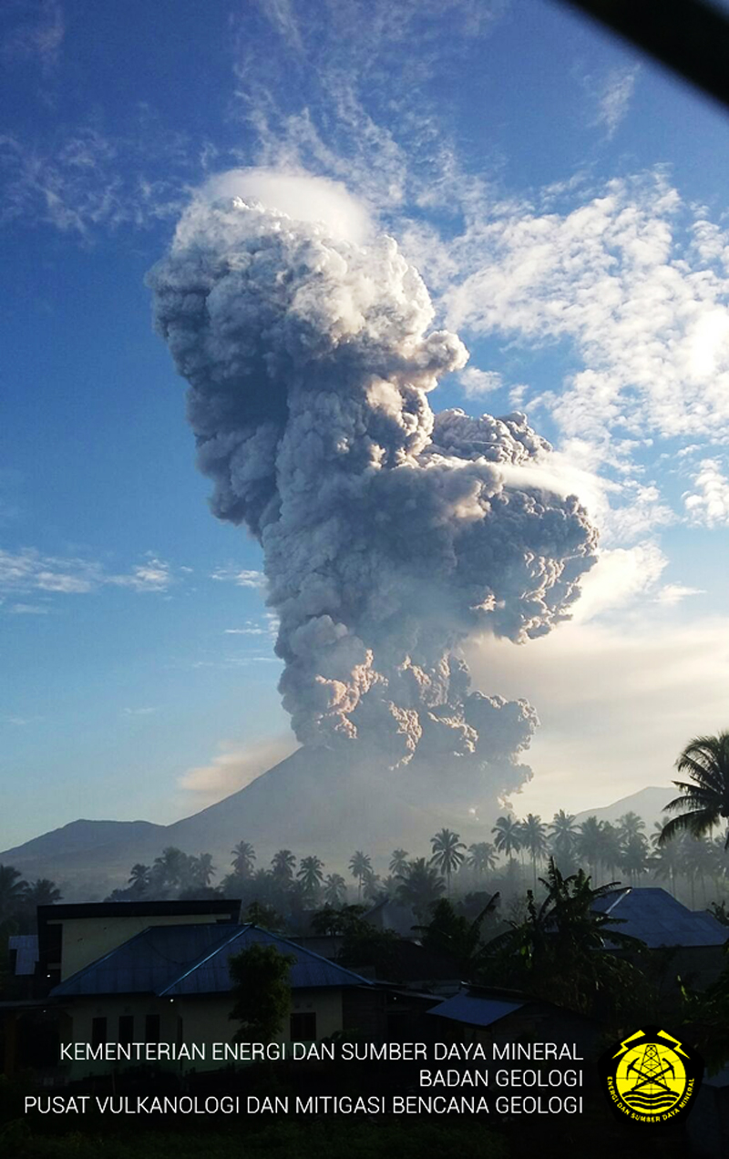 |
Figure 14. Soputan eruption during the morning hours of 5 January 2016 (local time). Photograph location uncertain but likely taken in the vicinity of Ronoketang, about 12 km S. Courtesy of PVMBG. |
A Strombolian phase early on 5 January lasted about 40 minutes and sent incandescent material 250 m high, according to BNPB. Sounds resembling thunder followed, and then a pyroclastic flow traveled 2.5 km down the ENE flank. An ash cloud rose 6.5 km above the summit crater rim (8.3 km altitude) and drifted W. Several villages in the districts of West Langowan (8 km E), Tompaso (11 km NE), and East Ratahan (14 km SE) reported ashfall.
MODVOLC thermal alert pixels likely associated with the eruption were reported during 6-8 January. A small cluster on 10 January located on the NE flank possibly indicated flowing or cooling lava. The Darwin VAAC reported another large ash plume on 14 January that rose to 13.7 km and drifted 45 km NE before dissipating.
A new series of explosions began on 6 February 2016. Ash plumes rose to 7 km altitude, later dropping to the range of 4.3-6 km, with continuous emissions drifting up to 75 km WSW through the next day. PVMBG reported lava flows on the N and E flanks; Strombolian explosions witnessed from the observation post in the village of Silian (about 10 km from the volcano) ejected material 300 m high. BNPB reported Strombolian activity on 7 February with ejected material as high as 1,000 m above the summit crater. Pyroclastic flows were also observed moving up to 2 km down the E flank. Seismic amplitudes remained high, indicating the active movement of magma within the volcano. Ashfall was reported in multiple districts including Pasan (5 km SSE), Tombatu (16 km SSW), Belang (17 km SSE), and Ratatotok (20 km S). The MODIS thermal anomaly data resulted in a very strong (32 pixel) MODVOLC thermal alert on 6 February. This corresponded with the Volcanic Radiative Power (VRP) spike presented in the MIROVA information for the same period (figure 12).
For the rest of February, only diffuse white steam plumes rose 75 m, except for a 700-m-high plume reported on 12 February by PVMBG; three MODVOLC thermal alert pixels were recorded on 11 and one on 13 February. Minor steam emissions rose to 100 m at the end of March, but the frequency of earthquakes associated with avalanches and low-frequency earthquakes were still elevated above background levels. The intensity of the avalanche-related earthquakes began to decline in the second week in April according to PVMBG. No incandescence was observed at the summit by the third week of April, and the decreasing frequency and amplitude of the earthquakes led PVMBG to lower the Alert Level to II on 21 April 2016. Between May and mid-September 2016, emissions from the volcano were characterized by white plumes of variable density ranging from 20 to 300 m above the crater and seismicity remained low (figure 15). The Alert Level remained at II.
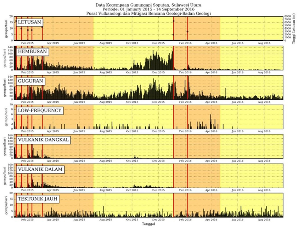 |
Figure 15. Seismicity at Soputan from 1 January 2015 through 14 September 2016. Dates of eruptive events are shown with red bars. Vertical axis on all graphs is daily frequency. LETUSAN is eruption, vertical axis on the right is height in meters above summit of ash plume observed by PVMBG; HEMBUSAN is emission related seismicity; GUGURAN is seismicity associated with rock avalanches; VULKANIK DANGKAL are shallow volcanic earthquakes; VULKANIK DALAM are deep volcanic earthquakes; TECTONIK JAUH are remote tectonic earthquakes. Courtesy of PVMBG (Soputan Report of activity through 14 September 2016). |
Geological Summary. The Soputan stratovolcano on the southern rim of the Quaternary Tondano caldera on the northern arm of Sulawesi Island is one of Sulawesi's most active volcanoes. The youthful, largely unvegetated volcano is the only active cone in the Sempu-Soputan volcanic complex, which includes the Soputan caldera, Rindengan, and Manimporok (3.5 km ESE). Kawah Masem maar was formed in the W part of the caldera and contains a crater lake; sulfur has been extracted from fumarolic areas in the maar since 1938. Recent eruptions have originated at both the summit crater and Aeseput, a prominent NE-flank vent that formed in 1906 and was the source of intermittent major lava flows until 1924.
Information Contacts: Pusat Vulkanologi dan Mitigasi Bencana Geologi (PVMBG, also known as Indonesian Center for Volcanology and Geological Hazard Mitigation, CVGHM), Jalan Diponegoro 57, Bandung 40122, Indonesia (URL: http://www.vsi.esdm.go.id/); Badan Nasional Penanggulangan Bencana (BNPB), National Disaster Management Agency, Graha BNPB - Jl. Scout Kav.38 East Jakarta 13120 (URL: http://www.bnpb.go.id/); Darwin Volcanic Ash Advisory Centre (VAAC), Bureau of Meteorology, Northern Territory Regional Office, PO Box 40050, Casuarina, NT 0811, Australia (URL: http://www.bom.gov.au/info/vaac/); Hawai'i Institute of Geophysics and Planetology (HIGP), MODVOLC Thermal Alerts System, School of Ocean and Earth Science and Technology (SOEST), Univ. of Hawai'i, 2525 Correa Road, Honolulu, HI 96822, USA (URL: http://modis.higp.hawaii.edu/); MIROVA (Middle InfraRed Observation of Volcanic Activity), a collaborative project between the Universities of Turin and Florence (Italy) supported by the Centre for Volcanic Risk of the Italian Civil Protection Department (URL: http://www.mirovaweb.it/).