Report on Kuchinoerabujima (Japan) — March 2017

Bulletin of the Global Volcanism Network, vol. 42, no. 3 (March 2017)
Managing Editor: Edward Venzke.
Edited by A. Elizabeth Crafford. Research and preparation by Paul Berger.
Kuchinoerabujima (Japan) Explosions on 3 August 2014, 29-30 May 2015 (with pyroclastic flow), and 18-19 June 2015
Please cite this report as:
Global Volcanism Program, 2017. Report on Kuchinoerabujima (Japan) (Crafford, A.E., and Venzke, E., eds.). Bulletin of the Global Volcanism Network, 42:3. Smithsonian Institution. https://doi.org/10.5479/si.GVP.BGVN201703-282050
Kuchinoerabujima
Japan
30.443°N, 130.217°E; summit elev. 657 m
All times are local (unless otherwise noted)
Intermittent ash explosions during the last century have characterized activity at Japan's Kuchinoerabujima volcano, located at the northern end of the Ryukyu Islands approximately 260 km S of Nagasaki, Japan. Brief periods of higher seismicity had been detected in the last approximately 30 years, although no explosions had been recorded since 1980 (BGVN 35:11 and 38:01). A new explosion occurred on 3 August 2014, and activity remained elevated through June 2015. Information on the latest activity is provided by the Japan Meteorological Agency (JMA) monthly reports and aviation alerts are from the Tokyo Volcanic Ash Advisory Center (VAAC).
A modest explosion from Shindake crater on 3 August 2014 caused JMA to increase the Alert Level at the volcano. Activity decreased shortly after the explosion, and only steam plumes, fumarolic activity, and occasional incandescence were observed for the next nine months. A large explosion on 29 May 2015 generated a gray-black ash plume that rose to over 9 km altitude and sent pyroclastic flows down the flanks; JMA increased the Alert Level and ordered evacuation of local residents. Activity declined after a few days, and Shindake remained quiet until a smaller explosion on 18 June 2015. The ash plume did not exceed 1 km, but ashfall was reported in towns on neighboring islands and in areas up to 80 km E. Two additional smaller explosions were reported on 18 and 19 June. Seismicity decreased significantly after the 19 June explosion, but SO2 emissions remained elevated until October 2015. The JMA did not lower the Alert Level until June 2016.
Activity during August 2014-February 2015. JMA reported an eruption from the vicinity of Shindake crater around noon local time on 3 August 2014, with a gray plume rising more than 800 m above the crater rim. This led to an increase in the Alert Level from 1 (Normal) to 3 (Do not approach the volcano) on a 5-level scale. An overflight confirmed traces of ash on the W flank. The Tokyo VAAC reported that the plume rose to an altitude greater than 1.5 km and drifted N. On 5 August, seismicity decreased, and views from a remote web camera showed a white plume rising 50 m above the crater rim. For the rest of August, seismicity remained low and steam plumes rose 50 to 800 m above the crater.
During September 2014, white plumes were generally observed 200-800 m above the crater when visibility was not obscured by weather; seismicity remained low. Scientists conducting a field survey on 12 September found SO2 emissions at 300 metric tons per day (t/d), higher than the background value of 60 t/d measured on 21 May 2014. Occasional earthquakes were recorded in October 2014, and the volume of gas emissions remained relatively high compared with before the August eruption; steam-and-gas plumes rose to 600 m above the crater rim. During field surveys on 7 and 8 October scientists measured SO2 emissions of 500 t/d. Gas emissions rose from within the Shindake crater, around a thermally anomalous fissure at the W edge of the crater, as well as from a new fumarole on the SW flank of the crater. In November, plumes continued to rise as high as 1,000 m above the crater. In another survey on 9 December 2014, scientists found that SO2 levels had increased to 1,700 t/d.
Emissions of SO2 remained high during the second half of January 2015, ranging from 1,100 to 3,100 t/d. A M 2.2 seismic event located 5 km beneath the island was recorded on 24 January. Observations made during field surveys in February confirmed continued steam emissions, and thermal anomalies from the W crater rim fissure and the new fissure on the SW flank. SO2 emissions decreased slightly from January levels to a range of 400 to 2,700 t/d in February, and steam plumes continued to rise 400-700 m above the crater.
Activity during March-June 2015. Incandescence at night was first recorded at the Shindake Crater from 24 to 31 March 2015 with a high-sensitivity camera. Aerial observation on 25 March by JMA and JCG (Japan Coast Guard) indicated a temperature rise and continued fumarolic activity around the thermal anomaly W of the crater rim. SO2 emissions remained high in March (1,000 to 3,700 t/d) and April (900 to 2,600 t/d), and steam plumes rose to 1 km above the crater. Incandescence was occasionally observed at night during April and again during 18-22 May; fumarolic activity continued along with a rise in temperature at the W and SW fissures. Steam plumes were observed rising to 600 m above the crater in May.
According to JMA, at 0959 local time on 29 May 2015, a large explosive phreatomagmatic eruption generated a gray-black ash plume that rose to over 9 km altitude and drifted ESE (figure 5). The plume was reported by the Tokyo VAAC to be at 10.9 km altitude about an hour after the eruption. The largest of several pyroclastic flows descended NW from the SW side of the crater in the Mukaehama district and reached the coast. Based on these events, JMA raised the Volcanic Alert Level to 5 (Evacuate). Aerial observation conducted on the same day (in collaboration with the Kyushu Regional Bureau of the Ministry of Land, Infrastructure, Transport and Tourism) revealed additional pyroclastic flows moving in nearly all directions from the Shindake crater (figure 6) including flows reaching halfway down the mountain to the SW and SE of the crater. Seismicity increased immediately after the eruption, but had decreased by midday.
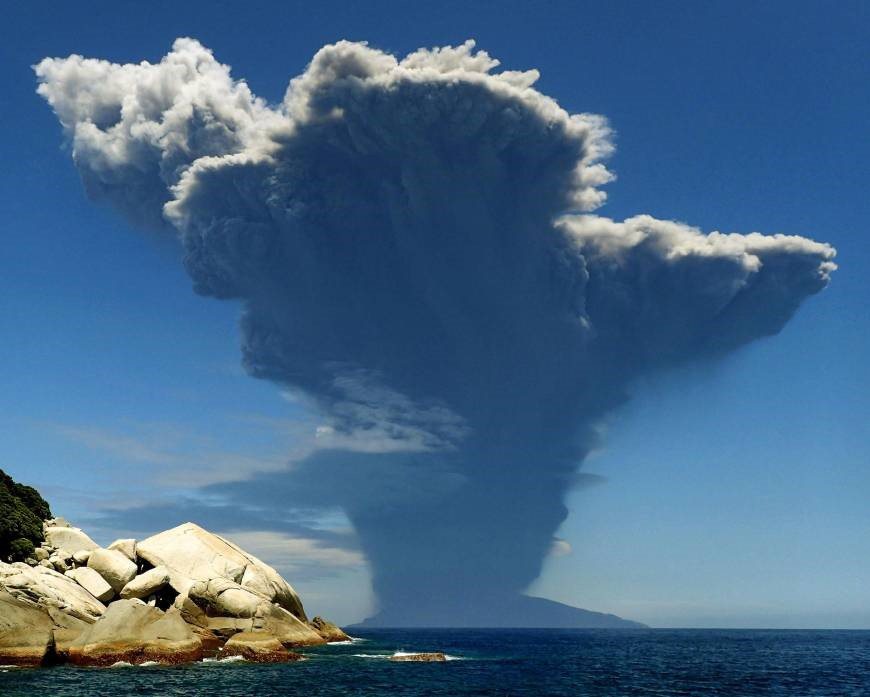 |
Figure 5. Ash plume from Kuchinoerabujima's Shindake Crater during an explosion on 29 May 2015. The plume height was reported by the Tokyo VAAC as 10.9 km altitude. Photo taken from the neighboring island of Yakushima by Itaru Takaku. Courtesy of Kyodo News and The Japan Times. |
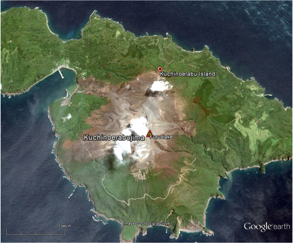 |
Figure 6. Google Earth imagery dated 5 June 2015, one week after a large explosion which generated several pyroclastic flows around the summit crater at Kuchinoerabujima. Note the brown areas extending in most directions away from the summit crater (beneath the white clouds), all the way to the coast on the NW and W flanks that are the result of the pyroclastic flows that occurred on 29 May 2015. Courtesy of Google Earth. |
According to a news article (The Japan Times), all residents and visitors (141 people) were safely evacuated by a ferry, coast guard ship, and helicopter to neighboring Yakushima Island (25 km SE). A resident of Yakushima reported that ash reached the island. Later that day, ash plumes rose 200 m and drifted SW.
Ash plumes continued the next day, 30 May, rising only 1.2 km. A field team observed discolored trees on the SE and SW flanks, and fallen trees near the coast on the NW flank. Cloud cover prevented views of the eruption area, but the team was able to confirm continued fumarolic activity and incandescence in the W part of the crater. Seismicity continued at low levels, and during the first week of June white plumes rose 100-400 m above the crater rim.
Another smaller eruption on 18 June 2015 caused lapilli and ash to fall on the E side of the island. Ash was reported in Yakushima Town (44 km ESE on Yakushima Island), Nishinoomote City (80 km NE on Tanegashima Island), and Nakatane Town (72 km E on Tanegashima). Small eruptions also occurred at 1631 on 18 June and at 0943 on 19 June. Tokyo VAAC reported the larger 18 June eruption, but plume heights were below 1 km, and not observed on satellite. Aerial observations on 20 June by JMA revealed no traces of new pyroclastic-flow deposits around the crater or on the flanks.
Post-eruption observations through June 2016. Emissions of SO2 remained elevated during June 2015 (800-1,700 t/d), and decreased somewhat in July to 500-700 t/d. They decreased further to 200-300 t/d in August. Increased seismicity was recorded briefly from 1-3 and 6-11 August. SO2 emissions continued to decline in September, except for a spike of 700 t/d on 10 September. Thermal infrared observations taken during a field survey in October 2015 indicated a decrease in temperature around the fissure W of the crater rim since the 29 May eruption. Emissions of SO2 remained below 300 t/d for the remainder of 2015 and no further activity was reported, although the Alert Level remained at 5. On 14 June 2016, JMA lowered the Alert Level to 3; seismic activity and SO2 flux values were below levels detected prior to the May-June 2015 eruption.
Geological Summary. A group of young stratovolcanoes forms the eastern end of the irregularly shaped island of Kuchinoerabujima in the northern Ryukyu Islands, 15 km W of Yakushima. The Furudake, Shindake, and Noikeyama cones were erupted from south to north, respectively, forming a composite cone with multiple craters. All historical eruptions have occurred from Shindake, although a lava flow from the S flank of Furudake that reached the coast has a very fresh morphology. Frequent explosive eruptions have taken place from Shindake since 1840; the largest of these was in December 1933. Several villages on the 4 x 12 km island are located within a few kilometers of the active crater and have suffered damage from eruptions.
Information Contacts: Japan Meteorological Agency (JMA), Otemachi, 1-3-4, Chiyoda-ku Tokyo 100-8122, Japan (URL: http://www.jma.go.jp/); Tokyo Volcanic Ash Advisory Center (VAAC), 1-3-4 Otemachi, Chiyoda-ku, Tokyo, Japan (URL: http://ds.data.jma.go.jp/svd/vaac/data/); Google Earth (URL: https://www.google.com/earth/); The Japan Times (URL: http://www.japantimes.co.jp/news/2015/05/29/national/volcano-erupts-isle-kagoshima-prompting-evacuation-order/).