Report on Ahyi (United States) — April 2017
Bulletin of the Global Volcanism Network, vol. 42, no. 4 (April 2017)
Managing Editor: Edward Venzke.
Edited by A. Elizabeth Crafford.
Ahyi (United States) Hydrothermal activity continues in December 2014
Please cite this report as:
Global Volcanism Program, 2017. Report on Ahyi (United States) (Crafford, A.E., and Venzke, E., eds.). Bulletin of the Global Volcanism Network, 42:4. Smithsonian Institution. https://doi.org/10.5479/si.GVP.BGVN201704-284141
Ahyi
United States
20.42°N, 145.03°E; summit elev. -75 m
All times are local (unless otherwise noted)
Ahyi seamount is one of a long string of submarine seamounts at the northern edge of the Northern Mariana Islands, part of the Mariana Back-arc segment of the Izu-Bonin trench in the western Pacific Ocean. The remote location of the seamount has made eruptions difficult to document, but seismic stations installed in the region confirmed an eruption in the vicinity in 2001. No further activity was reported until a new eruption was detected by seismic stations and felt by divers in the immediate area in April 2014. Volcanic activity in the Commonwealth of the Northern Mariana Islands is monitored by the US Geological Survey's Volcano Hazards Program, and observations are sometimes gathered by NOAA (National Oceanic and Atmospheric Administration) expeditions. The 2014 eruption and follow-up observations from December 2014 are summarized here.
The eruption at Ahyi seamount between 24 April and 17 May 2014 (BGVN 39:02; Haney et al., 2014) was first recorded as T-phase signals that were detected by various seismometers in the Mariana Islands. Submarine explosions were also heard and felt by NOAA scuba divers conducting coral reef research on the SE coastline of Farallon de Pajaros (Uracas) Island, about 20 km NW of Ahyi. In the same area, the NOAA crew reported sighting mats of orange-yellow bubbles on the water surface that extended up to 1 km from the shoreline. T-phase seismic signals registered across the Northern Mariana Islands (NMI) seismic network at a rate of approximately 10 per hour until 8 May, and then sporadically until 17 May (Haney et al., 2014).
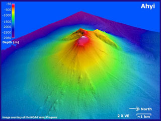
During mid-May, the NOAA ship Hi'ialakai gathered multibeam sonar bathymetry and took three water-column CTD casts (Conductivity, Temperature, and Depth sensor; it gives scientists a precise and comprehensive charting of the distribution and variation of water temperature, salinity, and density). The May 2014 bathymetry revealed that the minimum depth to the summit was about 90 m, notably deeper than the 60 m measured during a 2003 survey. In addition a new crater about 100 m deep had formed at the summit, replacing the summit cone. Also, a distinct landslide chute descended the SE slope 2,300 m, removing material from the head and depositing debris at the base (see figure 4, BGVN 39:02). Significant particle plumes were detected with all three CTD casts, indicating ongoing hydrothermal activity. Plumes with optical anomalies up to 0.4 NTU (nephelometric turbidity units) were found S and W of Ahyi at 100-175 m water depth, corresponding to the depth of the new summit crater. NTU's are light backscattering measurements done by optical sensors in sea water to determine the presence of hydrothermal plumes in the water column.
On 4 December 2014, the NOAA Expedition "Submarine Ring of Fire 2014 – Ironman" visited Ahyi, and again used a CTD sensor to assess the hydrothermal status of the volcano. EM122 multibeam bathymetry data imaged CO2 gas bubbles rising from the summit (figure 5), and clearly revealed the new summit crater. When the CTD sensor and sampling package was lowered into the water, it measured a thick plume of particles indicating ongoing hydrothermal activity near 150 m depth, close to the base of the new crater that formed during the eruption in April-May 2014.
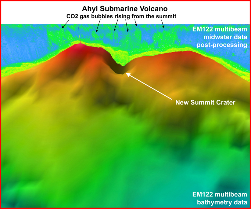 |
Figure 5. Three-dimensional image of the summit of Ahyi submarine volcano gathered on 4 December 2014 with the mid-water data shown above the new crater created by the April 2014 eruption. The summit crater is ~100 m deep. CO2 bubbles (in green) can be seen rising from most of the summit, suggesting that there is more than one source of venting. This image shows an area 850 m across with depths ranging from 78 (red) to 400 m (blue). No vertical exaggeration. Image courtesy of Submarine Ring of Fire 2014 - Ironman, NSF/NOAA (http://oceanexplorer.noaa.gov/explorations/ 14fire/logs/december04/media/ahyi.html). |
References: Haney, M. M., Chadwick, W., Merle, S. G., Buck, N. J., Butterfield, D. A., Coombs, M. L., Evers, L. G., Heaney, K. D., Lyons, J. J., Searcy, C. K., Walker, S. L., Young, C., and Embley, R. W., The 2014 Submarine Eruption of Ahyi Volcano, Northern Mariana Islands, American Geophysical Union, Fall Meeting 2014, abstract V11B-4727.
Geological Summary. Ahyi seamount is a large conical submarine volcano that rises to within 75 m of the ocean surface ~18 km SE of the island of Farallon de Pajaros in the northern Marianas. Water discoloration has been observed there, and in 1979 the crew of a fishing boat felt shocks over the summit area, followed by upwelling of sulfur-bearing water. On 24-25 April 2001 an explosive eruption was detected seismically by a station on Rangiroa Atoll, Tuamotu Archipelago. The event was well constrained (+/- 15 km) at a location near the southern base of Ahyi. An eruption in April-May 2014 was detected by NOAA divers, hydroacoustic sensors, and seismic stations.
Information Contacts: National Oceanic and Atmospheric Administration (NOAA), Office of Ocean Exploration and Research, 1315 East-West Highway, Silver Spring, Maryland, USA (URL: http://oceanexplorer.noaa.gov/welcome.html); US Geological Survey, Volcano Hazards Program (USGS-VHP), 12201 Sunrise Valley Drive, Reston, VA, USA (URL: https://volcanoes.usgs.gov/index.html).