Report on Asosan (Japan) — May 2017
Bulletin of the Global Volcanism Network, vol. 42, no. 5 (May 2017)
Managing Editor: Edward Venzke.
Edited by A. Elizabeth Crafford.
Asosan (Japan) Lengthy eruptive episode 25 November 2014-May 2015; major explosions on 14 September 2015 and 8 October 2016
Please cite this report as:
Global Volcanism Program, 2017. Report on Asosan (Japan) (Crafford, A.E., and Venzke, E., eds.). Bulletin of the Global Volcanism Network, 42:5. Smithsonian Institution. https://doi.org/10.5479/si.GVP.BGVN201705-282110
Asosan
Japan
32.8849°N, 131.085°E; summit elev. 1592 m
All times are local (unless otherwise noted)
Japan's 24-km-wide Asosan caldera on the island of Kyushu has been active throughout the Holocene. Nakadake has been the most active of 17 central cones within the caldera for 2,000 years. Historical eruptions have been primarily basaltic to basaltic-andesitic ash eruptions, with periodic Strombolian activity. Minor ash emissions during May-June 2011, January-February 2014, and August-September 2014 preceded a major eruptive episode which began in late November 2014 and continued through 1 May 2016. Another eruption, with the largest ash plume in 20 years, occurred on 8 October 2016. The Japan Meteorological Agency (JMA) provides regular reports of activity; the Tokyo Volcanic Ash Advisory Center (VAAC) issues aviation alerts reporting on possible ash plumes. This report covers the period from the beginning of the late 2014 episode through March 2017.
Minor ash eruptions occurred at Asosan during 13 January-19 February 2014 and 30 August-6 September 2014. Trace ashfall was reported on 24 October 2014. A new large eruptive episode began in late November with ash plumes and Strombolian activity that continued from 25 November 2014 through late May 2015. Ash explosions also occurred on 28 June, 8 August, and 3 and 10-11 September 2015. A large explosion with pyroclastic flows occurred on 14 September. This was followed by intermittent ash plumes until 23 October 2015. Minor ash explosions took place on 7 and 25 December 2015. More explosions with ash were recorded on 17-18 February, 4 March, 16 and 30 April, and 1 May 2016. Nakadake crater was then quiet until a large explosion with an 11.9-km-high ash plume on 8 October 2016, after which no further explosive activity was reported through March 2017.
Activity during January-October 2014. After no activity during 2012 and 2013, increased seismicity in December 2013 preceded a series of minor ash eruptions between 13 January and 19 February 2014 (BGVN 40:02). The largest, on 29 January, rose 2.7 km and drifted NW. The next episode began on 30 August and lasted for only a week until 6 September 2014. The ash plumes were continuous during most of this brief time, but only rose as high as 2.1 km, and drifted N and NE. Other than a small amount of ashfall reported on 24 October, only steam plumes issued from Nakadake between early September and 25 November, the beginning of a lengthy eruptive episode.
Activity during November 2014-May 2015. The details of the beginning of this episode have been covered in a previous Bulletin report (BGVN 40:02). Ashfall was reported from ash plumes in several directions (NE, WSW, SW) as far as 38 km away, although plume heights were seldom above 2.4 km altitude (figure 36). Incandescence was observed at night from the webcams. Strombolian activity occurred from two active vents at Nakadake, producing frequent explosions of incandescent material onto the crater rim (figure 37). Blocks up to 10 cm wide were observed by JMA scientists within 1.2 km SW of the crater in mid-December 2014.
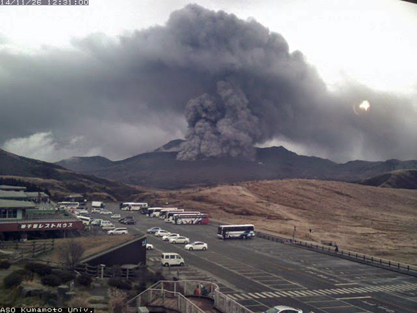 |
Figure 36. Ash plume from Asosan on 26 November 2014. Image taken from Kumamoto University webcam located about 1 km SW of Nakadake crater. Courtesy of Volcano Discovery. |
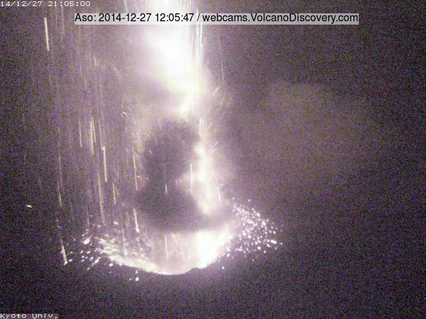 |
Figure 37. Strombolian activity at the Nakadake crater at Asosan on 27 December 2014. Image taken from the Kyoto University webcam located at Nakadake crater which was destroyed during a subsequent eruption. Courtesy of Volcano Discovery. |
Ash plumes and Strombolian activity continued from 25 November 2014 through late May 2015. The Tokyo VAAC issued near-daily reports through early May, when they became more intermittent until a month-long break beginning on 26 May. Plume heights were rarely higher than 1.5 km above the rim (3 km altitude). Field surveys noted intermittent ejecta from the Strombolian activity as high as 300 m above the crater rim. Ashfall was reported in the surrounding Kumamoto (W), Oita (NE), and Miyazaki (SE) prefectures (figure 38).
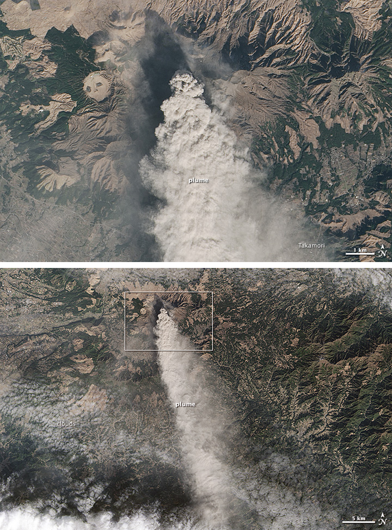 |
Figure 38. A dense ash plume drifting S from Asosan on 13 January 2015. The ash plume is visible for at least 30 km. Upper image is the inset box of lower image. Courtesy of NASA Earth Observatory. |
The JMA report for February 2015 noted that observations conducted by Kumamoto University indicated that as much as 1,500,000 tons of ash fell from the start of the eruption on 25 November 2014 through 2 February 2015. The results of GNSS (Global Navigation Satellite Systems) measurements suggested a slight inflation across Kusasenri, another cone located W of Nakadake, during February. In late April, ashfall was reported in areas to the SE and NE. A large-amplitude tremor that lasted for 5 minutes was recorded on 3 May. During a field survey on 5 May, JMA scientists observed that the S side of one of the pits (named the 141st pit) in the Nakadake crater had collapsed. On 26 May, an ash plume at 2.1 km altitude was reported 37 km NE of Kumamoto airport (about 25 km W of Asosan). This was the last ash plume reported until 28 June.
Activity during June-October 2015. A field survey by JMA personnel on 10 June noted a lake in part of the 141st pit. Thermal infrared measurements indicated temperatures of up to 80°C in the lake, which had not been observed since 8 July 2014; the lake had disappeared by 29 June. An ash plume was reported by the Tokyo VAAC drifting SW at 1.5 km altitude on 28 June.
Tremor amplitude began decreasing by mid-July, but the number of isolated tremors remained large. Steam plumes and a crater lake were again observed at the 141st pit in late July and August, and temperatures remained high (80-90°C) at the lake. A high-temperature fumarole (around 600°C) was observed SW of the 141st pit on 31 July and again during August. A small eruption was reported on 8 August by JMA with grayish plumes rising 600 m above the crater rim and minor ashfall reported on the S side of the crater. The Tokyo VAAC reported minor ash plumes on 3 and 10-11 September.
A series of new larger explosions began early on 14 September 2015 local time. JMA raised the Alert level from 2 (Do not approach the crater) to 3 (Do not approach the volcano) (on a scale of 1-5) the same day. The ash plumes were reported by JMA at 2,000 m above the crater rim drifting NW. A pyroclastic flow and ejecta impacted the immediate area around the crater. Aerial observation later that day noted discoloration extending 1.3 km SE and 1 km NE from the Nakadake crater as a result of the pyroclastic flow. Ashfall was also observed in areas to the W of the crater from northern Kumamoto Prefecture (including Tamana (50 km NW), Kumamoto City (40 km W), and Yamaga (40 km NW)) to Fukuoka Prefecture (more than 30 k NW). According to a news article in The Japan Times, about 30 tourists in the immediate area were evacuated, and some flights were either canceled or re-routed from Kumamoto Airport, 20 km W. Areas within 4 km of the craters were closed. The Tokyo VAAC reported the plume from the 14 September explosion at 3.7 km altitude drifting NW. During an overflight the following week, scientists observed evidence for pyroclastic flows as far as 3 km SE from the crater. Scientists from Kumamoto University estimated that about 40,000 tons of ash were ejected on 14 September.
Ash plumes were reported daily by the Tokyo VAAC until 23 October 2015, when several small explosions sent plumes up to 1.6 km above the crater rim. A field survey that day noted bombs scattered over the W and NW flank of the crater. After this, only steam plumes to 300 m above the rim were reported from Nakadake during November, leading JMA to lower the Alert level to 2 on 24 November.
Activity during December 2015-May 2016. A small explosion occurred on 7 December 2015. A field survey later that day revealed minor ashfall on the SW side of Nakadake crater. Visual confirmation of emissions associated with a relatively large-amplitude tremor on 25 December was obscured by clouds. During a 7 January 2016 survey, staff from JMA and the Aso Volcanological Laboratory observed fresh ejecta up to 0.5 m in diameter as far as 100 m SW of the crater rim, inferring that it resulted from the 25 December explosion.
The next reported ash eruptions took place on 17-18 February 2016. A field survey on 17 February revealed ashfall in Takamori (7 km SSE). Another survey on 18 February noted lapilli along the SW crater wall from the 17 February explosion. After the 18 February explosion, lapilli were observed 400 m NW of the crater and ashfall was noted in Aso City (10 km NE). Two MODVOLC thermal alerts on 28 February were located about 2 km NE of the active crater and likely unrelated to volcanic activity.
An explosion early in the morning on 4 March 2016 sent a milky-white plume to 1 km above the crater rim. A field survey later in the day confirmed slight ashfall on the E side of the crater. Small explosions were reported by JMA on 16 and 30 April. The Tokyo VAAC issued advisories, but ash was not detected in satellite imagery. The Tokyo VAAC issued no further advisories until 7 October 2016, although JMA noted a small explosion on 1 May with gray-white 'smoke' rising to 300 m above the crater. This was the last reported explosion by JMA until 7 October 2016. Seismic tremor amplitudes decreased after 15 May. During July through September, JMA noted that most of the crater floor was filled with hot water, and seismicity was low and intermittent.
Activity during October 2016-March 2017. After an explosion late in the day on 7 October 2016 and another one in the early hours of 8 October, JMA raised the Alert Level to 3. The Tokyo VAAC reported a large ash plume rising to 11.9 km altitude early on 8 October, and drifting NE. During an overflight on 8 October and a field survey on 12 October, significant ash deposits were observed (figures 39 and 40). They extended as far as 1.6 km on the NW flank and 1 km on the SE flank; ash was also abundant on the NE flank.
 |
Figure 39. View to the N of ash deposits around the Nakadake crater at Asosan after a large explosion on 8 October 2016. Photo by Kyodo/via Reuters. |
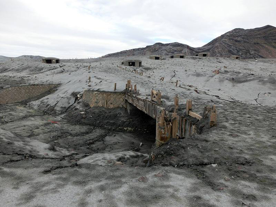 |
Figure 40. Area on the SW side of Asosan's Nakadake crater covered with ash by the explosion on 8 Oct 2016. Note the six bunkers on the left side of the crater in figure 39. They correspond to the bunkers in this image. Photo: JMA. Courtesy of Volcano Discovery. |
Ashfall 3 cm thick was reported at the Aso City police station 6 km NE of Nakadake crater in Kumamoto Prefecture (figure 41). Ashfall was also confirmed in Oita (50 km NE), Ehime (across the Inland Sea, 150 km NE), and Kagawa (300 km NE) prefectures. According to news articles (Reuters), ashfall was reported as far away as 320 km. Kyoto University Volcano Research Center estimated the amount of ash ejected on 8 October to be around 50-60,000 tons. Samples analyzed by the National Institute of Advanced Industrial Science and Technology (AIST) and the National Research Institute for Earth Science and Disaster Prevention (NIED) revealed a 10% juvenile magma component, and that the explosions were possibly phreatomagmatic. Inflation was recorded near the crater up until 8 October, after which it remained steady.
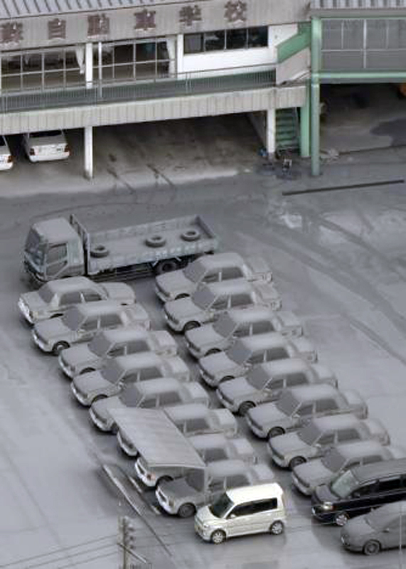 |
Figure 41. Cars are covered with volcanic ash from Asosan in Aso City, about 10 km NE of Nakadake crater in Kumamoto prefecture on 8 October 2016. Photo credit: Kyodo/via REUTERS. |
On 12 November 2016, JMA observed incandescence at night at Nakadake crater for the first time since 26 April 2015. While SO2 emissions were reported as continuous after the 8 October explosion, the volcano was otherwise quiet and JMA lowered the Alert Level to 2 on 20 December 2016. There was no change of activity during January 2017, and thus the Alert Level was lowered to 1 on 7 February 2017. Field surveys during February noted that 80% of the bottom of Nakadake was filled with hot water. JMA reported no further activity through the end of March 2017.
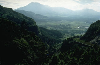
Geological Summary. The 24-km-wide Asosan caldera was formed during four major explosive eruptions from 300,000 to 90,000 years ago. These produced voluminous pyroclastic flows that covered much of Kyushu. The last of these, the Aso-4 eruption, produced more than 600 km3 of airfall tephra and pyroclastic-flow deposits. A group of 17 central cones was constructed in the middle of the caldera, one of which, Nakadake, is one of Japan's most active volcanoes. It was the location of Japan's first documented historical eruption in 553 CE. The Nakadake complex has remained active throughout the Holocene. Several other cones have been active during the Holocene, including the Kometsuka scoria cone as recently as about 210 CE. Historical eruptions have largely consisted of basaltic to basaltic andesite ash emission with periodic strombolian and phreatomagmatic activity. The summit crater of Nakadake is accessible by toll road and cable car, and is one of Kyushu's most popular tourist destinations.
Information Contacts: Japan Meteorological Agency (JMA), Otemachi, 1-3-4, Chiyoda-ku Tokyo 100-8122, Japan (URL: http://www.jma.go.jp/); Tokyo Volcanic Ash Advisory Center (VAAC), 1-3-4 Otemachi, Chiyoda-ku, Tokyo, Japan (URL: http://ds.data.jma.go.jp/svd/vaac/data/); NASA Earth Observatory, EOS Project Science Office, NASA Goddard Space Flight Center, Goddard, Maryland, USA (URL: http://earthobservatory.nasa.gov/); Tom Pfeiffer, Volcano Discovery (URL: http://www.volcanodiscovery.com/); The Japan Times (URL: http://www.japantimes.co.jp/news/2015/09/14/national/mount-aso-erupts-belching-black-plume/#.WRBxXlXyuJD); Reuters (URL: http://www.reuters.com/article/us-japan-volcano-idUSKCN12804E?il=0).