Report on Fuego (Guatemala) — June 2017

Bulletin of the Global Volcanism Network, vol. 42, no. 6 (June 2017)
Managing Editor: Edward Venzke.
Edited by A. Elizabeth Crafford.
Fuego (Guatemala) Ten eruptive episodes with lava flows, ash plumes, and pyroclastic flows during January-June 2016
Please cite this report as:
Global Volcanism Program, 2017. Report on Fuego (Guatemala) (Crafford, A.E., and Venzke, E., eds.). Bulletin of the Global Volcanism Network, 42:6. Smithsonian Institution. https://doi.org/10.5479/si.GVP.BGVN201706-342090
Fuego
Guatemala
14.4748°N, 90.8806°W; summit elev. 3799 m
All times are local (unless otherwise noted)
Volcán de Fuego has been erupting continuously since 2002. Historical observations of eruptions date back to 1531, and radiocarbon dates are confirmed back to 1580 BCE. These eruptions have resulted in major ashfalls, pyroclastic flows, lava flows, and damaging lahars. Fuego was continuously active from June 2014-December 2015. Ash plumes rose to 6 km altitude, ashfall was reported in communities as far as 90 km away, pyroclastic flows descended multiple drainages at least four times, Strombolian activity rose to 800 m above the summit, lava flows descended a few kilometers down five different drainages numerous times, and three different lahars damaged roadways (BGVN 42:05). This report continues with a summary of similar activity during January-June 2016. In addition to regular reports from INSIVUMEH, the Washington Volcanic Ash Advisory Center (VAAC) provides aviation alerts. Locations of towns and drainages are listed in table 12 (BGVN 42:05).
Daily weak and moderate explosions generating ash plumes to about 800 m above the summit (4.6 km altitude) that dissipated within about 10 km were typical activity for Fuego during January-June 2016. In addition, ten eruptive episodes were recorded during this time. Each episode lasted 24-72 hours, with all but one including incandescent material rising 200-400 m above the summit feeding lava flows down the larger drainages for several kilometers. Most also included pyroclastic flows down the larger drainages. One of the episodes consisted of only large pyroclastic eruptions (with an accompanying ash plume) that issued directly from the summit crater and down the ravines; all included ash plumes rising over 5 km in altitude. Several lahars were reported during late April-June.
Activity during 30 December 2015. INSIVUMEH reported a significant increase in activity on 30 December 2015. A series of pyroclastic flows descended the Las Lajas and El Jute drainages on the SE flank, and a dense ash plume rose to 5 km altitude and drifted 20 km W. Ashfall was reported in multiple communities on the flanks, including Panimache I and II (8 km SW), Morelia (9 km SW), and Santa Sofía (12 km SW).
Activity during January 2016. Two eruptive episodes with explosions that generated ash plumes, pyroclastic flows, Strombolian activity, lava flows, and ashfall were documented by INSIVUMEH during January 2016. The first eruption began with an increase in seismicity early in the morning of 3 January. Moderate to strong explosions were accompanied by an ash plume that rose to 4.8 km altitude (about 1 km above the summit) and drifted W and SW. Two lava flows emerged from the summit crater and traveled down the Las Lajas and Trinidad ravines. Moderate to strong explosions continued during 3 January. By the afternoon, dense plumes of ash were reported at 6 km altitude drifting SW and SE more than 40 km. Ashfall was reported in the villages of Panimaché I and II, Morelia, Santa Sofia, El Porvenir, La Rochela, Osuna, El Zapote and Rodeo. Also later in the day, incandescence was observed 400 m above the crater; it fed three lava flows in the Santa Teresa, Trinidad, and Las Lajas canyons that reached 2.5 km in length. Eruptive activity diminished after about 37 hours with weak bursts of ash rising to 4.6-4.7 km altitude on 5 January that drifted S, SW, and SE.
A smaller explosive event during 15-17 January produced block avalanches and created ash plumes that rose 450-750 m above the crater and drifted up to 12 km N and NE; four to five explosions per hour were detected. The second eruptive episode began with increased activity on 19 January; incandescent material was ejected 400-500 m above the summit, generating new lava flows to the same three canyons as the earlier eruption (Santa Teresa, Trinidad and Las Lajas) (figure 36). Ash emissions rose to 4.9 km altitude and drifted NE. Pyroclastic flows also descended the Las Lajas and El Jute canyons (figure 37).
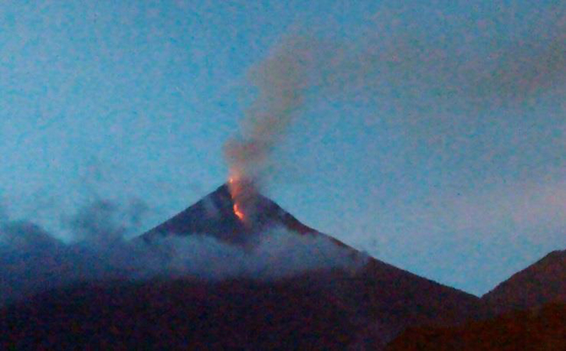 |
Figure 36. Lava flows towards Las Lajas Canyon on 19 January 2016 as viewed from the SE flank. Courtesy of INSIVUMEH-OVFGO (Informe Mensual De La Actividad Del Volcán Fuego, January 2016). |
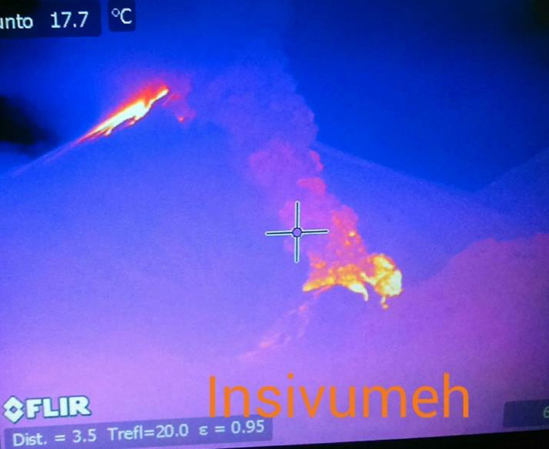 |
Figure 37. A pyroclastic flow descends towards the Las Lajas and El Jute ravines on the SE flank of Fuego on 19 January 2016 in this thermal image captured by INSIVUMEH. Courtesy of INSIVUMEH (Informe Mensual De La Actividad Del Volcán Fuego, January 2016). |
The second episode continued throughout 20 January 2016 when the largest ash plume rose to 6.7 km altitude and drifted NE more than 90 km according to the Washington VAAC. Ashfall was reported in San Miguel, Las Dueñas, Alotenango, Acatenango, and Antigua. Ash plumes from the pyroclastic flows also generated ashfall on the S and SW flanks (figure 38). By the morning of 21 January, the lava flows had ceased advancing at about 3 km length, although a hot spot was still clearly visible in satellite imagery. Weak explosions generated ash plumes that rose only a few hundred meters above the summit and drifted NNE. During January, the Observatorio del Volcan de Fuego installed a second webcam on the SE side of Fuego at the Finca La Reunión, a resort about 8 km from the summit. The first webcam is located about 10 km SW of the summit at the Observatorio del Volcan de Fuego in the community of Panimache.
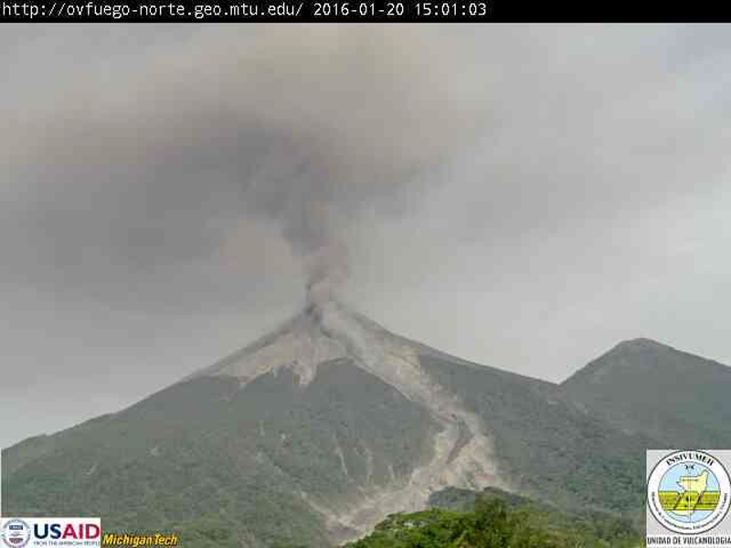 |
Figure 38. A pyroclastic flow on 20 January 2016 travels down the SE flank of Fuego, creating an ash cloud in the ravine. Additional ash emissions drifted in multiple directions. A recent lava flow is also visible in the ravine. View is from the La Reunión webcam, 8 km SE of the summit. Courtesy of INSIVUMEH (Informe Mensual De La Actividad Del Volcán Fuego, January 2016). |
Activity during February-March 2016. Explosions increased in number and energy on 5 February 2016, classified by INSIVUMEH as the 3rd episode of the year. Six moderate to strong explosions per hour were reported, sending ash emissions to 4.5 km altitude, drifting W, NW, and N more than 12 km, and avalanche blocks down the flanks to the base. The third eruptive episode of the year began with moderate explosions on 9 February 2016; it generated ash plumes which rose to 4.7 km altitude and dispersed up to 35 km NNW. Ashfall was reported in Chimaltenango, Zaragoza, Ciudad Vieja, San Pedro las Huertas, San Miguel Las Dueñas, San Juan Alotenango, Antigua Guatemala and the Capital City as far as 35 km N and NE. The explosions were accompanied by incandescent material rising to 300 m above the summit and feeding lava flows that traveled towards the Trinidad, Las Lajas, and Santa Teresa canyons, reaching lengths of 800 to 3,000 meters (figure 39).
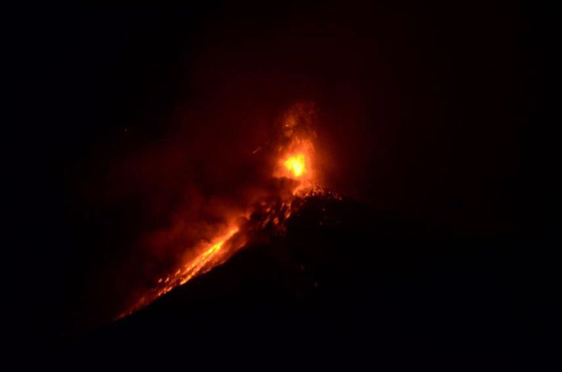 |
Figure 39. Incandescence rises 300 m above the crater at Fuego, generating lava flows down the Trinidad, Las Lajas and Santa Teresa canyons on 9 February 2016. Courtesy of INSIVUMEH (Informe Mensual De La Actividad Del Volcán Fuego, Febrero 2016). |
The following day (10 February 2016), pyroclastic flows descended the El Jute and Las Lajas ravines (figure 40) while ash plumes rose to 5.2 km altitude and incandescent material was ejected 400 m above the crater. Although activity decreased throughout the day, explosions continued to generate ash plumes to 4.9 km altitude that dispersed ash up to 45 km N and NE. Minor ash emissions were reported by the Washington VAAC on 17 February at 4.6-4.9 km altitude drifting SE about 40 km, and on 24 February at 4.6 km drifting about 25 km SW.
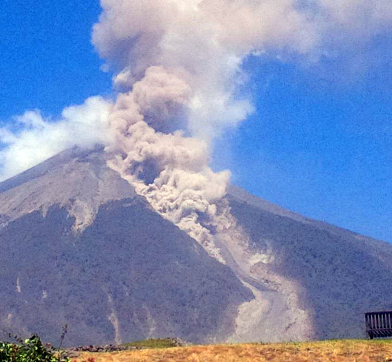 |
Figure 40. Pyroclastic flows descend the Las Lajas and El Jute ravines at Fuego on 10 February 2016 as viewed from the webcam at Finca la Reunión, 8 km SE. Courtesy of INSIVUMEH (Informe Mensual De La Actividad Del Volcán Fuego, Febrero 2016). |
On 29 February 2016, moderate to strong explosions at a rate of 6-10 per hour were heard more than 14 km away. They were accompanied by an ash plume that rose to 4.8 km and drifted 12 km E, and a lava flow that traveled 500 m towards Las Lajas ravine. This 4th eruptive episode (according to INSIVUMEH) lasted more than 72 hours (figure 41). On 2 March, several ash plumes rose to different altitudes and dispersed in different directions. The largest ash plume, was observed by the Washington VAAC at 7.3 km altitude; it was visible 400 km N before it dissipated into weather clouds. Lower altitude plumes rose to 4.6 km and drifted 75 km SW before dissipating. Ash fell in the communities of Morelia, Santa Sofia, La Rochela, Panimaché I and II, Sangre de Cristo, La Soledad and Yepocapa. The incandescent activity fed two lava flows; the first in the direction of Las Lajas reached 3 km, the second flowed towards El Jute ravine and reached 2 km in length. Pyroclastic flows also travelled down these two canyons and block avalanches descended the Honda Canyon. Explosive activity diminished during 3-6 March; ash emissions rose to 550 m above the summit and drifted 8-10 km W, SE, and SE.
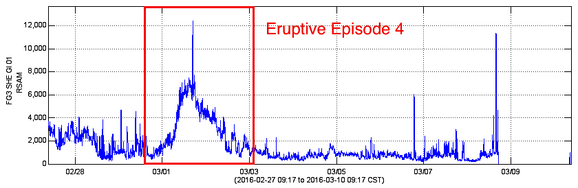 |
Figure 41. RSAM values spiked at Fuego during 29 February-3 March 2016 during eruptive episode 4. Courtesy of INSIVUMEH (Informe Mensual De La Actividad Del Volcán Fuego, Marzo 2016). |
During 10 March 2016, moderate to strong Vulcanian explosions generated an ash plume that rose to 4.4 km altitude and drifted E. The Washington VAAC observed ash emissions in multispectral satellite imagery on 15 March at 4.3 km altitude extending about 80 km SW from the summit as well as hot spots and pyroclastic flows visible in the INSIVUMEH webcam. An increase in activity on 21 March generated weak and moderate explosions that produced ash plumes that rose to 4.3-4.7 km and drifted W. This activity was recorded as an increase in RSAM tremor amplitude and duration at the FG3 seismic station, but was not considered an eruptive episode by INSIVUMEH (figure 42).
 |
Figure 42. Increases in RSAM tremor amplitude and duration at Fuego were recorded during 21 and 22 March, and eruptive episode 5 was recorded during 26 and 27 March 2016. Courtesy of INSIVUMEH (Informe Mensual De La Actividad Del Volcán Fuego, Marzo 2016). |
Eruptive episode 5 began on 26 March 2016 and lasted more than 24 hours (figure 42). Strombolian eruptions rose up to 500 m above the crater (figure 43), feeding three lava flows that traveled 2 km down Las Lajas, 1.3 km down the Santa Theresa, and 1 km down the Trinidad ravines. Ash plumes rose to 6.1 km altitude and drifted up to 150 km W (figure 44); ash fell on the villages of Morelia, Santa Sofia, San Predro Yepocapa, Panimaché I and II. By the end of 27 March, eruptive activity had diminished to background conditions, which included weak and moderate explosions generating ash plumes to about 800 m above the summit (4.6 km altitude) that dissipated within about 10 km WSW. On 29 March ashfall was reported Sangre de Cristo and Panimaché I and II.
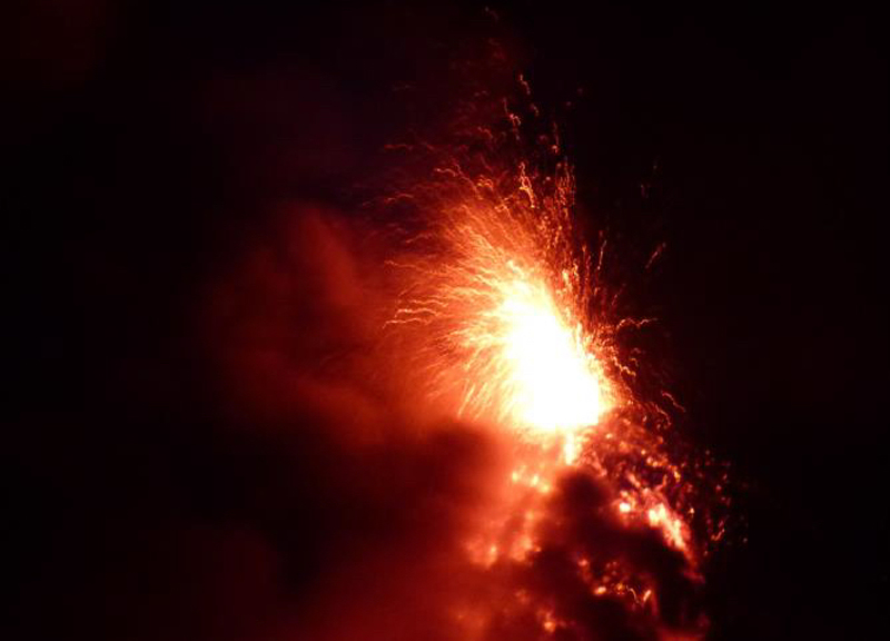 |
Figure 43. Strombolian activity rises 300 m above the crater at Fuego on 26 March 2016. Photo by Gustavo Chigna, courtesy of INSIVUMEH (Informe Mensual De La Actividad Del Volcán Fuego, Marzo 2016). |
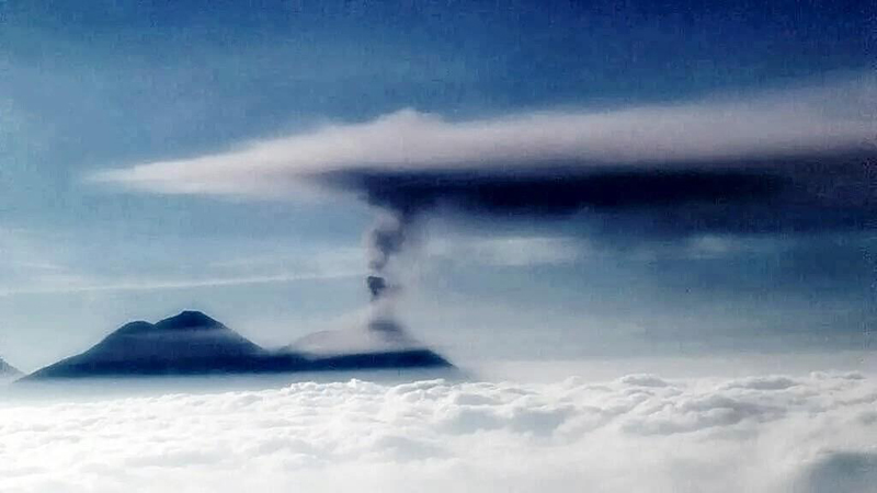 |
Figure 44. An ash plume at Fuego rose to over 6 km altitude on 26 March 2016 and drifted 150 km W before dissipating. Courtesy of INSIVUMEH (Informe Mensual De La Actividad Del Volcán Fuego, Marzo 2016). |
Activity during April-May 2016. The Washington VAAC reported diffuse volcanic ash emissions in satellite and webcam imagery on 2 April 2016. The ash plume drifted W at 4.3 km altitude, and extended 75 km from the summit before dissipating. Increased eruptive activity during 6-7 April 2016 resulted in moderate and strong explosions which produced ash plumes rising to 4.6-4.8 km altitude that drifted W and SW 15 km. The explosions were audible more than 20 km from the volcano; roofs and windows vibrated within 12 km. INSIVUMEH received reports of ashfall from the villages of Morelia, Sangre de Cristo, and Panimche I and II.
An explosion on 8 April created an ash plume that rose to 5.8 km and drifted SSW about 35 km. Successive bursts of ash on 9 April rose to 4.9 km altitude and drifted W. Emissions on 11 April were reported at 4.3 km altitude about 15 km SW from the summit; the next day they rose to 4.9 km and drifted SW to a distance of 45 km. INSIVUMEH reported variable activity beginning on 11 April with high levels of explosive activity on 12 April marking the beginning of the sixth eruptive episode of the year, which lasted for three days. An incandescent fountain persisted 100-300 m above the crater and fed two lava flows during the event; one traveled 2 km down the Las Lajas ravine, and the other reached 1 km in length in the Santa Teresa ravine. Avalanches were constant along the flanks during this episode. Continuous ash emissions were observed as well; plumes generally rose no higher than 5.8 km (2 km above the summit). Ashfall was reported in La Rochela, Ceylon, Morelia, Hagia Sophia, Sangre de Cristo, Panimaché I and II. On 13 April the ash plume extended 185 km SW from the summit. A brilliant hotspot was observed in satellite imagery on 14 April after which no further VAAC reports were issued until early May. On 29 April, after more than a week of rain, a lahar descended the Las Lajas drainage but no damage was reported.
Activity at Fuego increased significantly during May 2016, and included three eruptive episodes that generated ash plumes, pyroclastic and lava flows, and increased rainfall that resulted in lahars. Ash plumes rose above 5.5 km altitude (more than 2 km above the summit) and dispersed to the S, SW, and SE. Seismic activity increased on 5 May in the form of internal vibrations caused by lava which flowed more than 1.2 km down the Las Lajas ravine, and moderate to strong explosions that produced ash plumes which rose to 4.8 km altitude and drifted S for 12 km. The Washington VAAC reported diffuse ash extending 65 km SE from the summit.
The 7th eruptive episode of the year began on 6 May 2016 with incandescent material rising 300 m above the summit crater, causing two lava flows. One traveled down Las Lajas ravine more than 3 km; the second descended the Trinidad ravine for 1.5 km. Block avalanches were constant around the crater rim. The episode lasted for more than 32 hours (figure 45); the moderate to strong explosions ejected ash to altitudes above 5.5 km that drifted S and SW. Ashfall was reported in Escuintla and its surroundings. There were no pyroclastic flows during this episode. The Washington VAAC reported emissions extending 65 km SE of the summit at 5 km altitude on 6 May.
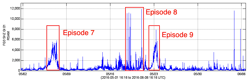 |
Figure 45. RSAM values during 2 May-6 June 2016 helped INSIVUMEH to define eruptive episodes for 2016 at Fuego, along with observed activity. Eruptive episode 7, consisting of Strombolian activity, lava flows, and ash plumes, occurred during 6-7 May 2016. Episode 8 comprised ash plumes and several large pyroclastic flows that descended the S flank during 18 and 19 May, but no seismic explosive activity. Increases in explosive activity on 21 May marked the beginning of episode 9, which lasted through 23 May 2016 and included incandescent fountains, lava flows, and ash plumes. Courtesy of INSIVUMEH (Informe Mensual De La Actividad Del Volcán Fuego, Mayo 2016). |
The next eruptive episode (8) did not involve seismic explosive activity (figure 45). Instead, several large pyroclastic flows overflowed the crater rim on 18 and 19 May 2016 and descended the flanks towards Las Lajas and Honda ravines (figure 46) resulting in ashfall reported to the S, SW, and W, in villages more than 30 km away. A large ash plume reached more than 5.5 km altitude and drifted 15 km SSW on 19 May (figure 47). Ashfall was reported in the villages of El Rodeo, La Rochela, Osuna, Panimaché, Morelia, Sangre de Cristo and Yepocapa. By late in the day, the Washington VAAC noted that the plume was centered about 90 km SW at 5.8 km altitude.
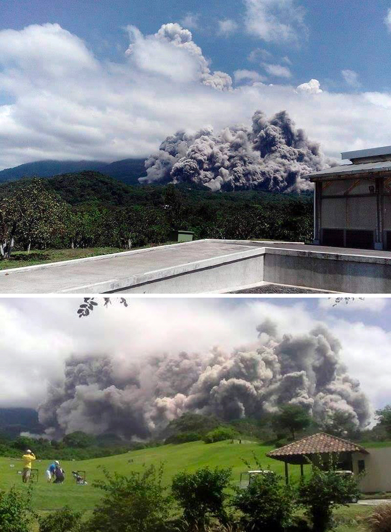 |
Figure 46. A pyroclastic flow descends Las Lajas ravine on the S flank of Fuego on 18 May 2016 in these images taken from Finca La Reunión. Lower photo by Basilo Sul, both images courtesy of INSIVUMEH (Informe Mensual De La Actividad Del Volcán Fuego, Mayo 2016). |
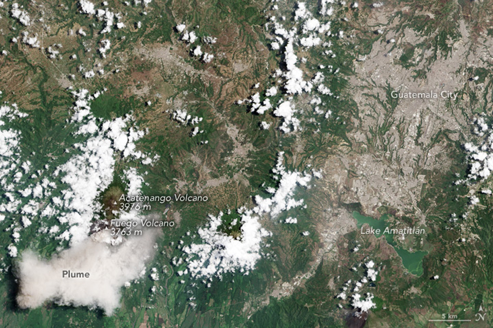 |
Figure 47. An ash plume drifts SW from Fuego on 19 May 2016 after a series of pyroclastic flows and ash emissions sent ash plumes to over 5 km altitude. The Operational Land Imager instrument on Landsat 8 captured this image. Courtesy of NASA Earth Observatory. |
The ninth eruptive episode of 2016 generated incandescent fountains 200-300 m above the summit; they fed a 2-km-long lava flow down the Las Lajas ravine (figure 48). Seismic activity began to increase on 21 May and lasted through 23 May (see figure 45). Moderate and strong explosions created an ash plume that rose to 5.5 km altitude and drifted SW and W. The Observatory reported ashfall in Morelia, El Porvenir, Santa Sofia, Los Yucales, Panimaché I and II. The Washington VAAC reported an ash plume visible in satellite imagery at 5.5 km altitude, drifting 75 km S beyond the coast on 23 May 2016. A lahar descended the Las Lajas ravine on 20 May and was recorded by the seismic station FG3, but no damage was reported.
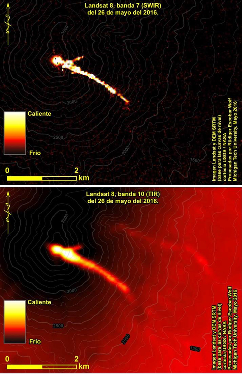 |
Figure 48. Landsat band 7 (top) and band 10 (bottom) images of the still-cooling lava flow in Las Lajas ravine at Fuego on 26 May 2016. Courtesy of Rudiger Escobar, Michigan Technological University and INSIVUMEH (Informe Mensual De La Actividad Del Volcán Fuego, Mayo 2016). |
Activity during June 2016. A significant rainfall combined with the plentiful ash from recent pyroclastic flows, resulted in lahars descending Las Lajas and El Jute ravines on 5 June 2016. They transported blocks, branches, and tree trunks, and a strong sulfur smell was reported by nearby residents. Another lahar was reported on 18 June that was 15 m wide and had a 1.5-m-high front. An increase in seismic activity during the afternoon of 24 June signaled the beginning of eruptive episode 10. This was followed by about 30 hours of moderate to strong explosive activity that could be heard and felt as far as 12 km away. A dense ash plume on 25 June rose to 5.5 km altitude and drifted S, SW, and W more than 40 km. Ashfall was reported in San Pedro Yepocapa, Sangre de Cristo, Morelia, Santa Sofia, Panimaché I and II. The Washington VAAC observed the ash plume in multispectral imagery on 25 June extending 120 km WSW from the summit. NASA Goddard Space Flight Center captured a small but distinct SO2 plume from Fuego on 25 June as well (figure 49). Incandescent material rose 300 m above the summit crater during this episode and fed three lava flows; the first descended Las Lajas ravine 2.5 km, the second traveled 2.3 km down El Jute ravine, and the third flowed down Taniluyá ravine for 600 meters. Seismic activity from episode 10 decreased on 26 June.
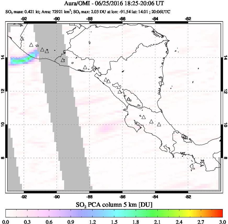 |
Figure 49. A small but distinct SO2 anomaly was measured from Fuego on 25 June 2016. INSIVUMEH reported the 10th eruptive episode of the year during that time with a dense ash plume and lava flows emerging from the summit crater. Courtesy of NASA Goddard Space Flight Center. |
Geological Summary. Volcán Fuego, one of Central America's most active volcanoes, is also one of three large stratovolcanoes overlooking Guatemala's former capital, Antigua. The scarp of an older edifice, Meseta, lies between Fuego and Acatenango to the north. Construction of Meseta dates back to about 230,000 years and continued until the late Pleistocene or early Holocene. Collapse of Meseta may have produced the massive Escuintla debris-avalanche deposit, which extends about 50 km onto the Pacific coastal plain. Growth of the modern Fuego volcano followed, continuing the southward migration of volcanism that began at the mostly andesitic Acatenango. Eruptions at Fuego have become more mafic with time, and most historical activity has produced basaltic rocks. Frequent vigorous eruptions have been recorded since the onset of the Spanish era in 1524, and have produced major ashfalls, along with occasional pyroclastic flows and lava flows.
Information Contacts: Instituto Nacional de Sismologia, Vulcanologia, Meteorologia e Hydrologia (INSIVUMEH), Unit of Volcanology, Geologic Department of Investigation and Services, 7a Av. 14-57, Zona 13, Guatemala City, Guatemala (URL: http://www.insivumeh.gob.gt/); Washington Volcanic Ash Advisory Center (VAAC), Satellite Analysis Branch (SAB), NOAA/NESDIS OSPO, NOAA Science Center Room 401, 5200 Auth Rd, Camp Springs, MD 20746, USA (URL: http://www.ospo.noaa.gov/Products/atmosphere/vaac/, archive at: http://www.ssd.noaa.gov/VAAC/archive.html); NASA Earth Observatory, EOS Project Science Office, NASA Goddard Space Flight Center, Goddard, Maryland, USA (URL: http://earthobservatory.nasa.gov/); NASA Goddard Space Flight Center (NASA/GSFC), Global Sulfur Dioxide Monitoring Page, Atmospheric Chemistry and Dynamics Laboratory, 8800 Greenbelt Road, Goddard, Maryland, USA (URL: https://so2.gsfc.nasa.gov/).