Report on Piton de la Fournaise (France) — July 2017

Bulletin of the Global Volcanism Network, vol. 42, no. 7 (July 2017)
Managing Editor: Edward Venzke.
Edited by A. Elizabeth Crafford.
Piton de la Fournaise (France) Intermittent effusive episodes during February-October 2015; May and September 2016; and February 2017
Please cite this report as:
Global Volcanism Program, 2017. Report on Piton de la Fournaise (France) (Crafford, A.E., and Venzke, E., eds.). Bulletin of the Global Volcanism Network, 42:7. Smithsonian Institution. https://doi.org/10.5479/si.GVP.BGVN201707-233020
Piton de la Fournaise
France
21.244°S, 55.708°E; summit elev. 2632 m
All times are local (unless otherwise noted)
Short pulses of intermittent eruptive activity have characterized Piton de la Fournaise, the large basaltic shield volcano on Reunion Island in the western Indian Ocean, for several thousand years. Recent eruptive episodes on 21 June 2014 and activity that started on 4 February 2015 have already been reported (BGVN 40:02). This report covers the remainder of the 2015 eruptive episode, and additional activity through May 2017. Information about Piton de la Fournaise is provided by the Observatoire Volcanologique du Piton de la Fournaise (OVPF) and satellite instruments.
A one-day fissure eruption on the ESE side of the central cone of the summit caldera on 21 June 2014 created a 1.5-km-long flow. This was followed by seven months of quiet. There were four effusive eruption events during 2015. The 4-15 February event occurred on the W side of the Dolomieu summit cone and the lava flow traveled about 2.5 km S. Effusion during 17-30 May started outside and SE of the Dolomieu Crater and traveled 4 km before it ceased. The brief 30 July-2 August event erupted from a 1-km-long fissure in the NE part of the l'Enclos Fouqué caldera and produced dozens of lava fountains. During 24 August-31 October a more sustained eruption from a fissure on the S flank of Dolomieu Crater sent lava flows at least 3.5 km down the flank to the S. Piton de la Fournaise experienced two effusive episodes in 2016. The 26-27 May event caused lava fountains on the SE flank of Dolomieu Crater. During 11-18 September, several fissures opened in the N part of the l'Enclos Fouqué caldera and produced numerous lava fountains and a lava flow. An effusive event on the SE flank of the summit crater during 31 January-27 February 2017 sent lava through tubes and flowed several kilometers to the SE before subsiding.
Activity during June 2014 and February 2015. The one-day eruption on 21 June 2014 consisted of a fissure eruption that was entirely contained within the Enclos Fouqué (the summit caldera) on the ESE side of the central (Dolomieu) cone. A lava fountain at the fissure created a spatter rampart and two lava flows that traveled about 1.5 km to the SE (BGVN 40:02).
The next eruption began abruptly on 4 February 2015 at a fissure on the W side of the summit cone adjacent to Bory crater (see figure 87), and lava flowed generally S, reaching about 2.5 km in length by 8 February (figure 88). The MODVOLC thermal alert signal for this event was detected over 4-14 February, and indications of continuing activity ceased by 15 February. OVPF partially reopened access to the volcano on 21 February.
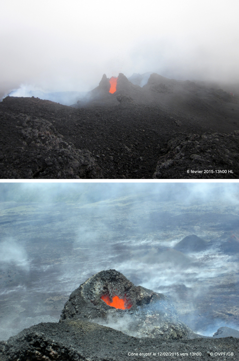 |
Figure 88. The eruptive cone from the 4-15 February 2015 eruption at Piton de la Fournaise. Upper image: 6 February 2015; lower Image: 12 February 2015. Courtesy of OVPF (Bulletin d'acitivité du Piton de la Fournaise du 15 février 2015 à 9h00 Locale). |
Activity during May 2015. A brief increase in seismic activity, continued deformation, and increased magmatic gas emissions occurred on 29 April, but no effusive activity took place. A 90-minute seismic swarm of 200 volcano-tectonic (VT) events followed by significant deformation at the summit crater preceded a new effusive eruption at 1345 on 17 May. The eruption started outside and SE of Dolomieu crater in the Castle crater area. Volcanologists noted lava fountains from three fissures, and two lava flows. A very large gas plume emitted during the first few hours of the eruption rose 3.6-4 km above the summit and drifted NW. The fissure furthest W stopped issuing lava fountains before midnight.
On 18 May only one fissure was active and the SSW-drifting gas plume was much smaller. Hydrogen sulfide emissions continued to be high, and carbon dioxide emissions increased. Lava fountains from a single vent along the second fissure, further E, rose 40-50 m. The lava flow had traveled 4 km, reaching an elevation of 1.1 km. On 19 May, scientists observed lava fountains 20-30 m high, and noted the lava flow which had traveled 750 m in the previous day, reaching 1 km elevation. Lava-flow rates estimated by satellite data fluctuated but showed an overall decrease from 24.2 m2/s on 17 May to 2.5 m2/s on 21 May. During 21-22 May observers reported large variations in activity, including increasing heights of the lava fountain (over 50 m high), collapsing parts of the newly formed cinder cone, and a new very fluid lava flow adjacent to the main flow.
During an overflight on 23 May scientists observed a large blue sulfur dioxide plume above the vent, lower lava fountains, a smaller vent in the cone, and the presence of a lava tube about 200 m downstream of the vent. During 24-25 May activity remained unchanged; low lava fountains and low-level lava flows persisted (figure 89). OVPF reported that the eruption continued through 30 May 2015 after which tremor was no longer detected. The MODVOLC thermal alerts for this event agreed well with the observations of the volcanologists. Strong multi-pixel alerts were issued daily from 17-30 May.
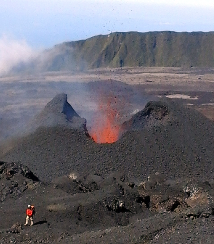 |
Figure 89. Eruptive cone at Piton de la Fournaise on 24 May 2015. Courtesy of OVPF (Observations des 24 et 25 mai 2015). |
Activity during 30 July-2 August 2015. A brief spike in seismicity on 6 July was the only notable activity after 30 May prior to a new eruptive episode that began on 30 July with a sharp increase in seismicity, increased gas emissions, and deformation near the summit. A fissure eruption began the next day at 0920, preceded by 90 minutes of high seismicity and 80 minutes of major deformation; it was confirmed by a hiker and then by observation of a gas plume. The 1-km-long fissure opened in the NE part of the l'Enclos Fouqué caldera and produced dozens of lava fountains (figure 90). Based on satellite images and gas data, the flow rate was estimated to be 28 m2/s initially and then 11 m2/s later that day. A gas plume rose to altitudes of 3.2-3.5 km. By the evening there were only five fountains, and a lava flow had traveled as far E as Plaine des Osmondes (NE part of the caldera). According to an AP news article, lava fountains were 40 m high, forming 20-m-high cones on 31 July. At 1115 on 2 August tremor stopped after several hours of fluctuating intensity, indicating the end of effusive activity.
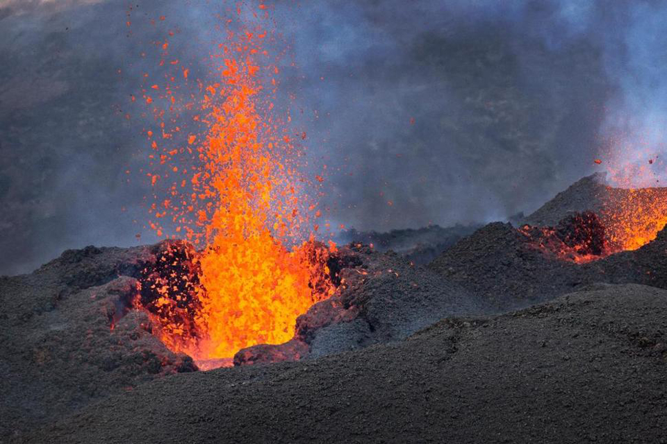 |
Figure 90. Fountains of lava erupt from a 1-km-long fissure that opened in the NE part of the l'Enclos Fouqué caldera at Piton de la Fournaise on 1 August 2015. AP Photo by Ben Curtis, courtesy of the Associated Press. |
Activity during 24 August-November 2015. The government reopened access to the caldera on 20 August; this was very short-lived, however, as a new eruption began on 24 August that continued through November 2015. Sulfur dioxide gas emissions increased at 1600, and the seismic and deformation network indicated a magmatic intrusion beginning at 1711 (figure 91). Lava fountains were visible at 1850 from a fissure on the S flank of Dolomieu Crater, at about 2,000 m elevation, near Rivals Crater. The fissure propagated towards the top of Rivals, and at around 2115 a fissure opened to the NW, below Bory Crater. The lava-flow rate was 30-60 m2/s . By the next morning fountains at higher elevations ceased, and were only active from a 100-m-long section near Rivals crater. The lava flow rate had significantly decreased to 10 m2/s . Near the top of the active fissure, a small cone had formed 140 m E of the sign to Rivals crater.
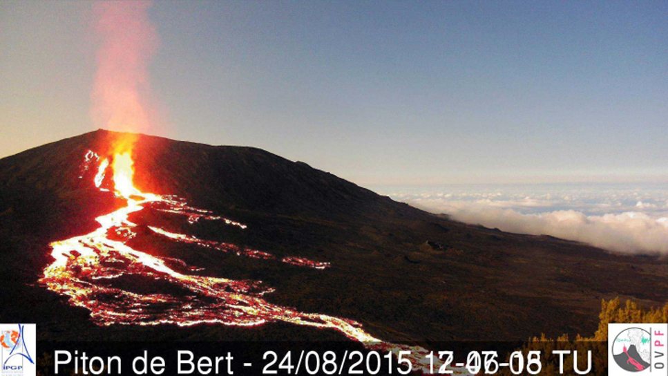 |
Figure 91. New lava flows at Piton de la Fournaise on the S flank of Dolomieu Crater, 24 August 2015. To create this image, OVPF superimposed a daytime image taken earlier the same day onto one showing the nighttime lava flows, which allows the location of the activity to be better identified. Images taken from the Piton de Bert webcam. Courtesy of OVPF (Localisation des coulees vers 21h00 le 24/08/2015). |
OVPF reported that the eruption fluctuated during the rest of August, causing variations in the height of the lava fountains and emissions. One vent remained active, and lava flows from it traveled at least as far as 3.5 km during 27-28 August. During an overflight the next day, scientists observed two growing cinder cones with lava lakes and lava fountains. An 'a'a lava flow was active, and a large gas plume rose 3 km.
Scientists conducting fieldwork during 31 August-1 September observed an active cone (20 m high) filled with a lava lake. Fluctuating lava fountains rose 15-20 m above the surface and gas bubbles exploded. Lava traveled through a 50-m-long lava tube and extended a distance of 1 km. During 1-2 September, seismicity increased and the lava flow grew to 2 km long (figure 92). Lava was observed in two separate side-by-side vents on 4 September (figure 93), and lava fountains were lower compared to recent days. Five small lava flows were visible near the foot of the cone; four were 30 m long and the fifth was 1 km long.
 |
Figure 92. Thermal measurements of an active lava flow on 3 September 2015 at Piton de la Fournaise. Courtesy of OVPF (Bulletin d'activité du vendredi 4 septembre 2015 à 09h00). |
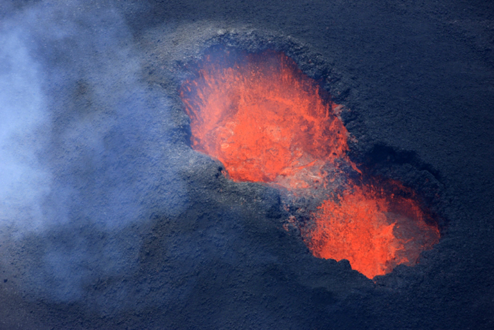 |
Figure 93. Side-by-side eruptive vents at Piton de la Fournaise on 4 September 2015. Courtesy of OVPF (Bulletin d'activité du samedi 5 septembre 2015 à 15h00). |
The side-by-side vents remained active through 17 September, after which only one was active. Lava flows emerged from and were active beyond a 50-100 m lava tube; the largest lava flows were up to 1.5 km in length. During 22-23 September a new lava tube formed to the W of the lava field. By 24 September the active cone was 30 m high; lava fountains were lower and less frequently observed but lava flows continued to be active, traveling as far as 3 km S and E (figure 94). OVPF reported that seismicity at Piton de la Fournaise slowly increased during the last week of September, and deformation data showed a trend of deflation during the last few days of the month. During fieldwork on 27 September volcanologists noted continuous lava fountains. Small lava flows were active, though the fronts of the two larger ones were no longer advancing.
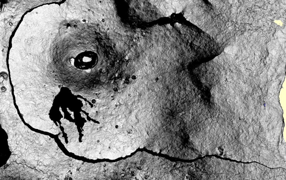 |
Figure 94. Map-view image showing lava flows created between 24 August and 28 September 2015 at Piton de la Fournaise. Contour extraction was performed using the coherence images (obtained in the interferogram production chain) produced by the OI2 observation service. Courtesy of OVPF/IPGP and JL. Froger LMV/OPGC (Bulletin d'activité du vendredi 2 septembre 2015 à 07h00). |
During the first two weeks of October, the lava lake remained active; bursting gas bubbles ejected lava onto the edges of the 30-35-m-high cone. Pahoehoe lava flows issued from ephemeral vents on lava tubes, and in many instances hornitos were built at these vents. Lava was active as far as 2.5 km from the base of the cone and burned vegetation near the base of Piton de Bert. The lava-flow rate peaked at 11 m2/s during 1-4 October then returned to the previous rate of 5-10 m2/s. On 7 October lava flowed out of a breach in the cone. The evolution of the morphology of the eruptive vent changed from a fissure to a single cone between late August and early October (figure 95).
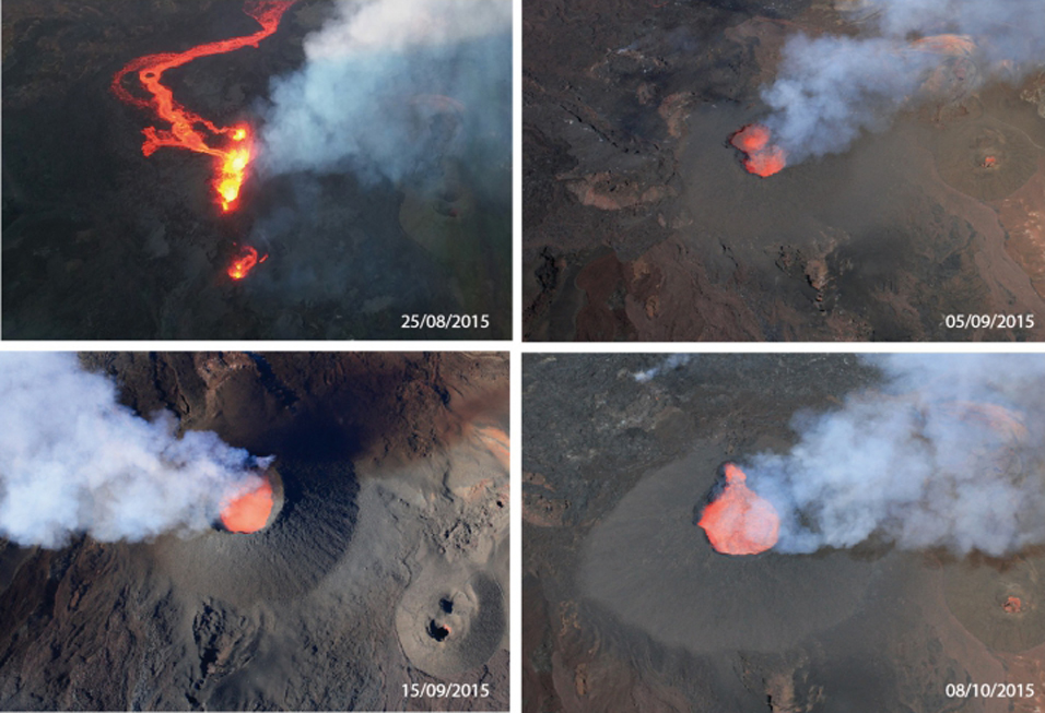 |
Figure 95. Evolution of the morphology of the eruptive cone at Piton de la Fournaise, 25 August-10 October 2015. Courtesy of OVPF (Bulletin d'activité du vendredi 9 octobre 2015 à 19h00) |
On 12 October there was a strong increase in tremor intensity, with values reaching or exceeding those detected during the first few hours of the eruption (24 August). Strain measurements showed continued deflation. A hornito SW of the cone ejected spatter during 13-14 October. Activity continued to increase on 16 and 17 October (figure 96). The cone continued to grow; the base was 100 m in diameter and it was about 40 m high. Parts of the cone rim continued to collapse, and a notch in the rim allowed for periodic lava-lake overflows. Increased SO2 flux created bubbles in the lava that caused ejection and spattering of large amounts of lava around the vent rim.
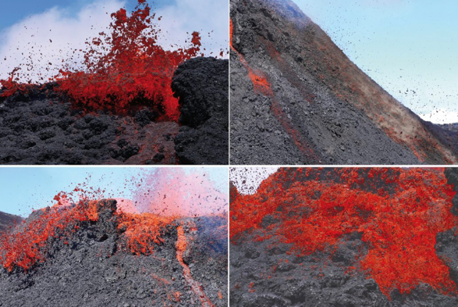 |
Figure 96. Large amounts of lava spattered around the rim of the active vent at Piton de la Fournaise on 16 October 2015 (Bulletin d'activité du samedi 17 octobre 2015 à 08h00). |
Tremor ceased abruptly on 19 October. Observers reported that a small explosion in the vent ejected spatter on 22 October, but lava flows were not observed. Lava fountains were visible from the main 24 August vent on 30 October for the last time (figure 97).
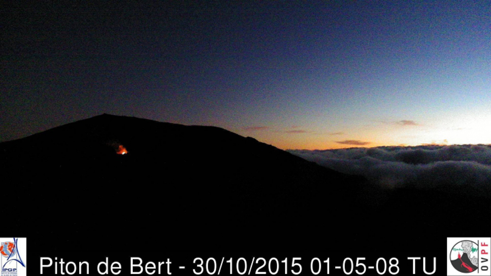 |
Figure 97. Lava fountains were observed for the last time in the early morning on 30 October 2015 from the vent of the 24 August 2015 eruption (Bulletin d'activité du vendredi 30 octobre 2015 à 07h00). |
OVPF reported that based on the change in seismic and lava flow activity, the effusive phase of the eruption beginning on 24 August had ended by 31 October 2015. They noted that during a few days before 11 November, the networks had recorded geophysical and geochemical signs of pressurization within the volcano. They also observed during aerial reconnaissance on 11 November persistent white fumarolic activity reflecting the high temperature of the lava field. Indications of inflation ceased at the end of November. MODVOLC thermal alerts became sporadic during November and ceased altogether on 2 December 2015 for more than five months.
MODVOLC thermal alerts for 2015. The MODVOLC thermal alerts captured for Piton de la Fournaise during 2015 show the differing locations of the four effusive eruptions (figure 98). The 4-14 February episode was located on the W side of the summit cone adjacent to Bory crater, in the W side of the Enclos Fouqué summit caldera. The 17-30 May episode extended farther E than that of the February event. A 1-km-long fissure opened in the NE part of the l'Enclos Fouqué caldera for the brief 31 July-1 August episode. Activity was concentrated on the S flank of the Dolomieu Crater during the lengthier 24 August-31 October effusive episode.
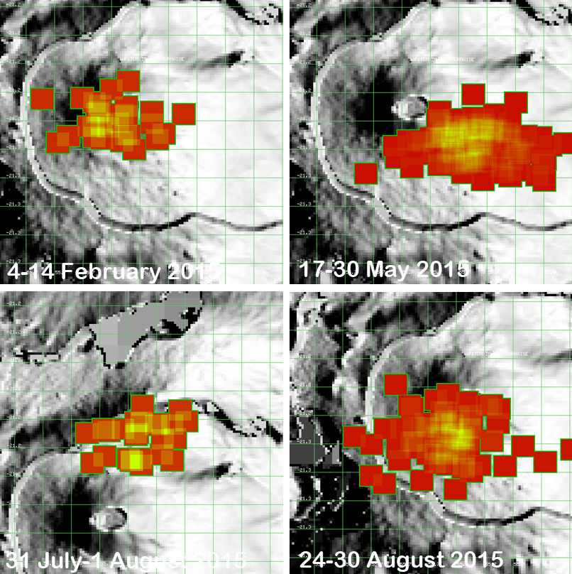 |
Figure 98. MODVOLC thermal alerts for the four eruptive episodes of 2015 at Piton de la Fournaise. The 4-14 February activity was located on the W side of the summit cone adjacent to Bory crater, in the W side of the Enclos Fouqué summit caldera. The 17-30 May episode extended farther E than that of the February event. A 1-km-long fissure opened in the NE part of the l'Enclos Fouqué caldera during the 31 July-1 August. Activity was concentrated on the S flank of the Dolomieu Crater during the lengthier 24 August-31 October effusive period; only the first week of thermal activity is shown here. Courtesy of MODVOLC. |
Sulfur Dioxide flux during 2015. Images captured by the OMI (Ozone Monitoring Instrument) on the Aura satellite showed significant SO2 plumes during three of the 2015 eruptive episodes, especially at the onset of the activity (figure 99). Dobson Unit (DU) values greater than 2 are shown as red pixels in the images. The largest plumes of SO2 captured during 2015 were after the effusive episodes had ended on 24 and 31 October 2015 (figure 100).
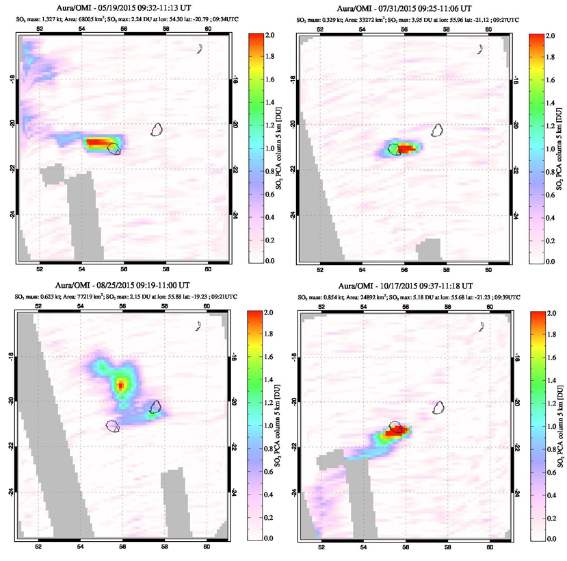 |
Figure 99. Images of SO2 flux at Piton de la Fournaise during three of the eruptive episodes during 2015. Dobson Unit (DU) values greater than two are shown as red pixels. On 19 May 2015, the SO2 plume drifts W (top left). The plume captured on 31 July 2015 is drifting E (top right). The lower two images are the second day (25 August) and the last day (17 October) that effusive activity was reported by OVPF for that eruptive episode. Courtesy of NASA Goddard Space Flight Center (NASA/GSFC). |
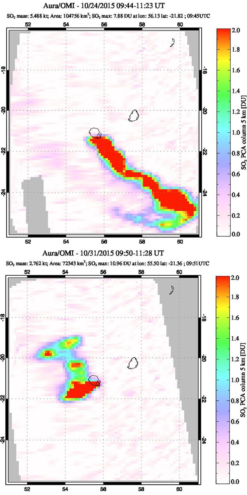 |
Figure 100. Images of SO2 flux at Piton de la Fournaise on 24 and 31 October 2015. Courtesy of NASA GSFC. Top: The large, 7.88 DU plume drifts SE from Reunion Island on 24 October. Bottom: Another plume with 10.96 DU SO2 drifted W and N from the island on 31 October. Courtesy of NASA/GSFC. |
Activity during 2016. Piton de la Fournaise experienced two effusive episodes in 2016, one occurred during 26-27 May, and the other during 11-18 September. The GPS networks detected evidence of inflation on 24 January 2016. This lasted until the second week of February when weak deflation was recorded. OVPF reported that CO2 gas emission, deformation, and seismicity began to slowly increase on 16 May, and then seismicity significantly increased at 1140 on 25 May. Tremor began at 0805 on 26 May, characteristic of an ongoing eruption, likely from a new fissure near Château Fort crater. Bad weather prevented visual observations of the area at first, though at 0900 ground observers confirmed a new eruption. Later that day scientists and reporters saw about six lava fountains (some were 40-50 m high) during brief aerial surveys and a cinder cone being built on a flat area at 1850 m elevation about 1-1.5 km SE of Castle Crater. On 27 May, tremor levels significantly dropped at 0845 and then ceased at 1100. Signals indicative of degassing continued. The lava fountains on 26 May were located on the SE flank of the main Dolomieu Crater south of the locations of both the May and August 2015 episodes (figure 101).
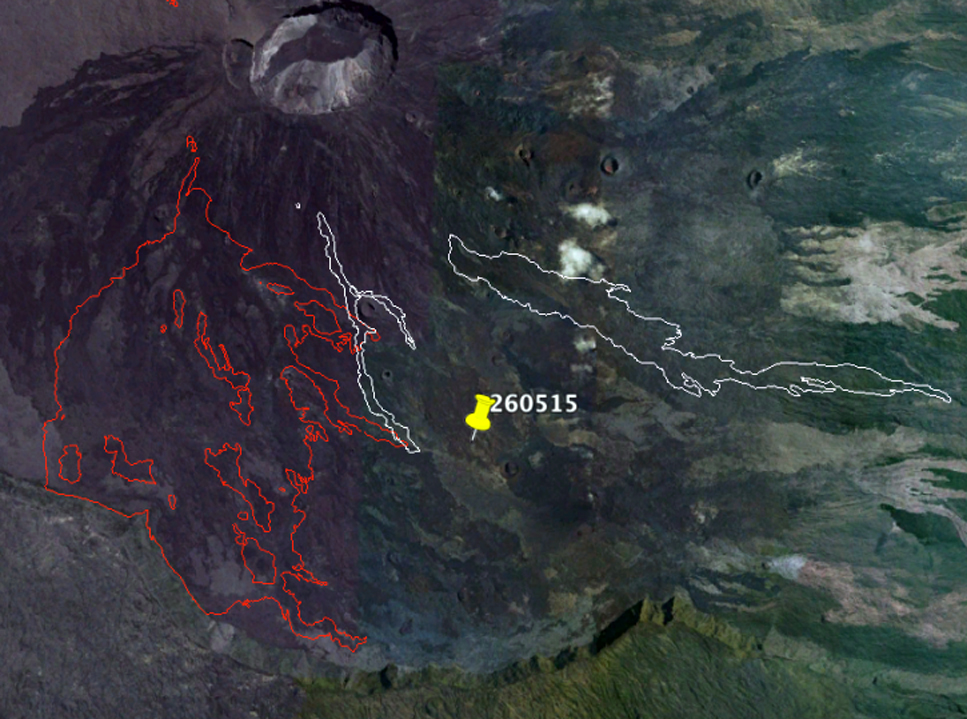 |
Figure 101. The location of the highest elevation point of the 26 May 2016 effusive episode at Piton de la Fournaise is shown by the yellow pin (260515 should be 260516), as recorded that day by the Section Aerienne de la Gendarmerie (SAG, the French Air Force). In white and red, respectively, are the contours of the eruptions of May and August 2015 (Bulletin d'activité du jeudi 26 mai 2016 à 22h00). |
Significant inflation continued after the 26-27 May eruption until mid-June (more than two centimeters between 27 May and 8 June) when it levelled off, and then began again in mid-July along with increased seismicity beginning on 13 July that lasted through the remainder of the month. OVPF reported that seismicity remained low during August. Gas emissions were also low and dominated by water vapor; CO2 emissions had been elevated during 21-27 July. Inflation had stopped in early August and slight deflation was detected through 2 September.
Seismicity increased on 10 September, and elevated levels of SO2 were detected at fumaroles. A seismic swarm occurred at 0735 on 11 September, characterized by several earthquakes per minute. Deformation suggested magma migrating to the surface. Volcanic tremor began at 0841, indicating the beginning of the eruption. Several fissures opened in the N part of the l'Enclos Fouqué caldera, between Puy Mi-côte and the July 2015 eruption site, and produced a dozen 15-30-m-high lava fountains distributed over several hundred meters. The eruption continued on the next day.
OVPF reported that volcanic tremor stabilized during 14-17 September. Field observations on 15 September revealed that the two volcanic cones that had formed on the lower part of the fissures had begun to coalesce (figure 102). Lava from the northernmost cone flowed N and NE, and by 0900 was active midway between Piton Partage and Nez Coupé de Sainte Rose. The height of the lava fountains grew in the afternoon, rising as high as 60 m, likely from activity ceasing at the southernmost cone and focusing at one main cone. On 16 September the main cone continued to build around a 50-m-high lava fountain; lava flows from this vent traveled NE. Tremor rose during the night on 17 September, and then fell sharply at 0418 on 18 September, indicating the end of surface activity. During 11-18 September, the erupted volume was an estimated 7 million cubic meters. By 26 September, earthquake frequency had decreased to less than five per day.
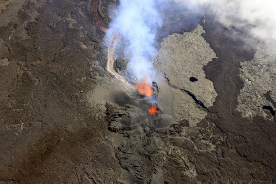 |
Figure 102. View of the eruptive site at Piton de la Fournaise on 15 September 2016 at 0930. The two cones are coalescing into one. Courtesy of OVPF/IPGP (copyright OVPF / IPGP; Bulletin d'activité du jeudi 15 septembre 2016 à 16h30). |
Following the slight deflation observed during the eruption (11-18 September), inflation began again on 18 September, slowed significantly by 1 October and ceased by 6 October. Inflation resumed at the summit on 12 December, and increased summit seismicity was reported by OVPF on 22 December 2016.
Activity during January-May 2017. A return to background levels of seismicity (0-1 events per day) and a slowdown in inflation were reported on 9 January 2017. Inflation resumed on 22 January. This was interpreted by OVPF to represent the deep-seated magma supplies beginning to feed the surface reservoir about 1.5-2 km under the summit craters once again. Following a seismic swarm beginning at 1522 on 31 January, seismic tremor indicated that a new effusive eruption began at 1940 on 31 January.
Visual observations on 1 February confirmed that the active vent was located about 1 km SE of Château Fort and about 2.5 km ENE of Piton de Bert (figure 103). Lava fountains rose 20-50 m above the 10-m-high vent, and 'a'a lava flows branched and traveled 750 m (figure 104). Two other cracks had opened at the beginning of the eruption, but were no longer active. Tremor levels decreased in the early hours of the eruption; lava-fountain heights were variable (between 20-50 m).
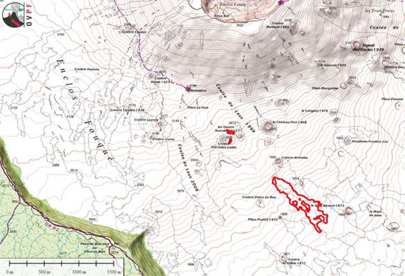 |
Figure 103. Topographic map showing the location of the 1 February 2017 eruption vent. Piton de Bert is located in the lower left (SW) corner at the caldera edge. The plot of the lava flows at 0830 is shown. Smaller red areas NW of flow are eruptive cracks that opened briefly at the beginning of the eruption. Base map courtesy of IGN, data courtesy of OVPF/IPGP (copyright OVPF / IPGP; Bulletin d'activité du mercredi 1 février 2017 à 17h00). |
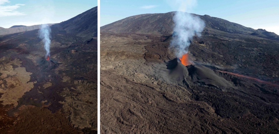 |
Figure 104. The eruptive site at Piton de la Fournaise on 1 February 2017 at 0740. Courtesy of OVPF (copyright OVPF / IPGP; Bulletin d'activité du mercredi 1 février 2017 à 09h00). |
On 2 February, two lava fountains at the vent were visible, and lava flows had traveled an additional 500 m E (figure 105). The vent was 128 m long and about 35 m high at the highest part. On 4 February OVPF noted that significant fluctuations of volcanic tremor were detected for more than 24 hours, with intensity levels reaching those observed at the onset of the eruption. Higher levels of seismicity continued through 7 February.
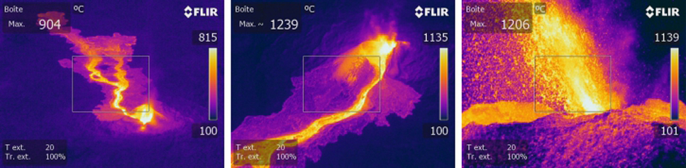 |
Figure 105. Thermal images of the Piton de la Fournaise eruptive site from 1 and 2 February 2017. Left and center are aerial views taken in on 2 February at 0845, and the right image is a ground view from 1 February at 1000. Courtesy of OVPF (copyright OVPF / IPGP; Bulletin d'activité du jeudi 2 février 2017 à 16h00). |
OVPF reported that during 8-14 February volcanic tremor was high, with levels reaching those observed at the onset of the eruption on 31 January. The eruptive vent was perched on top of a cone that was 30-35 m high and 190 m wide at the base (figure 106). The lava level inside of the cone was low, or about half of cone's height, and incandescent material was ejected from the vent. Inflation stopped on 11 February. The lava flow reached its farthest extent on 10 February, almost 3 km SE of the vent (figures 107 and 108).
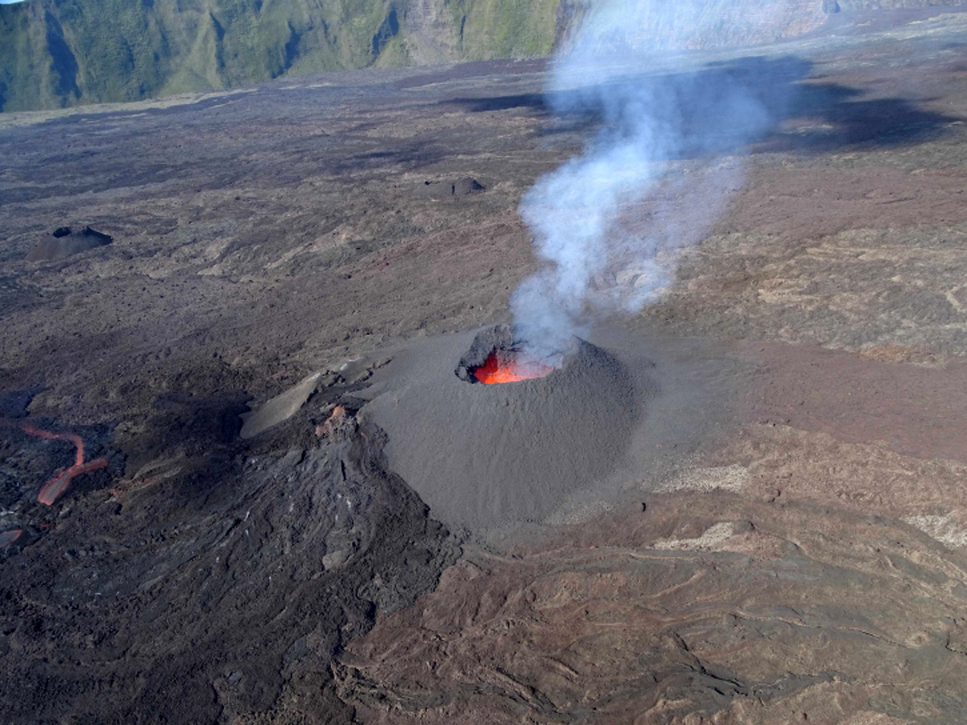 |
Figure 106. The eruptive cone at Piton de la Fournaise on 10 February 2017 at 0850. The lava is exiting the cone from the side and then flowing SE. Courtesy of OVPF (copyright OVPF / IPGP; Bulletin d'activité du vendredi 10 février 2017 à 17h00). |
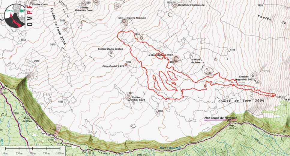 |
Figure 107. Approximate location of Piton de la Fournaise lava flows as of 10 February 2017 at 0850, interpreted from aerial photographs (IGN background map). Courtesy of OVPF (copyright OVPF / IPGP; Bulletin d'activité du vendredi 10 février 2017 à 17h00). |
 |
Figure 108. The front of the lava flow at Piton de la Fournaise on 10 February at 0730. View is looking SE, see flow location on topographic map in figure 107. Courtesy of OVPF (copyright OVPF / IPGP; Bulletin d'activité du vendredi 10 février 2017 à 17h00). |
Volcanic tremor fluctuated during 14-21 February. Observations made on the ground on 16 February by the observatory teams indicated that activity continued mainly in lava tubes. Only a few flows were visible a hundred meters downstream of the eruptive cone. A resumption of inflation was confirmed on 20 February.
During 25-26 February OVPF observers noted ejections of material from the active vent. A few skylights in the lava tubes were spotted. Late at night on 26 February tremor began to decline, and ceased at 1010 the next morning. Mid-day on 27 February observers confirmed that no material was being ejected from the vent, and that only white plumes were rising; gas emissions ceased at 1930. OVPF reported that the 28-day eruption at Piton de la Fournaise, beginning on 31 January and ending on 27 February, was estimated to have produced between 8 and 10 million cubic meters of lava. Although the eruption had ended on 27 February, inflation at the summit continued until about 7 March. It resumed at a low rate in mid-April, along with minor seismicity.
A new seismic swarm began at 1340 on 17 May and was accompanied by rapid deformation that suggested rising magma; volcanic tremor was recorded at 2010. The seismic and deformation activity was located in the NE part of l'Enclos Fouqué caldera. During an overflight at 1100 on 18 May scientists observed no surface activity at the base of the Nez Coupé de Sainte Rose rampart (on the N side of the volcano) nor outside of l'Enclos Fouqué caldera, and suggested that fractures opened but did not emit lava.
Seismicity increased again at 0400 on 18 May. The number of shallow (2 km depth) volcano-tectonic earthquakes progressively decreased over the next three days. During a field visit on 22 May scientists mapped the deformation associated with the 17 May event and measured displacements which did not exceed 35 cm. The 17-18 May activity resulted in two new zones of fumaroles that followed the trends seen in seismic and deformation data. Inflation stopped around mid-June, and seismicity was minimal for the remainder of the month.
MIROVA thermal data for 2016 and January-May 2017. Plots of thermal anomaly data by the MIROVA system correlated with the eruptive activity of 26-27 May 2016, 11-18 September 2016, and 31 January-27 February 2017 (figure 109). The thermal signatures of the September 2016 and February 2017 episodes show continued cooling of the new lava flows for several weeks after the effusive activity ceased.
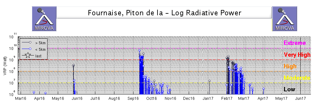 |
Figure 109. MIROVA data for Piton de la Fournaise from March 2016 through May 2017. The thermal signatures of the September 2016 and February 2017 events show continued cooling of the new lava flows for several weeks after the effusive activity ceased. Courtesy of MIROVA. |
Geological Summary. Piton de la Fournaise is a massive basaltic shield volcano on the French island of Réunion in the western Indian Ocean. Much of its more than 530,000-year history overlapped with eruptions of the deeply dissected Piton des Neiges shield volcano to the NW. Three scarps formed at about 250,000, 65,000, and less than 5,000 years ago by progressive eastward slumping, leaving caldera-sized embayments open to the E and SE. Numerous pyroclastic cones are present on the floor of the scarps and their outer flanks. Most recorded eruptions have originated from the summit and flanks of Dolomieu, a 400-m-high lava shield that has grown within the youngest scarp, which is about 9 km wide and about 13 km from the western wall to the ocean on the E side. More than 150 eruptions, most of which have produced fluid basaltic lava flows, have occurred since the 17th century. Only six eruptions, in 1708, 1774, 1776, 1800, 1977, and 1986, have originated from fissures outside the scarps.
Information Contacts: Observatoire Volcanologique du Piton de la Fournaise, Institut de Physique du Globe de Paris, 14 route nationale 3, 27 ème km, 97418 La Plaine des Cafres, La Réunion, France (URL: http://www.ipgp.fr/); Hawai'i Institute of Geophysics and Planetology (HIGP), MODVOLC Thermal Alerts System, School of Ocean and Earth Science and Technology (SOEST), Univ. of Hawai'i, 2525 Correa Road, Honolulu, HI 96822, USA (URL: http://modis.higp.hawaii.edu/); MIROVA (Middle InfraRed Observation of Volcanic Activity), a collaborative project between the Universities of Turin and Florence (Italy) supported by the Centre for Volcanic Risk of the Italian Civil Protection Department (URL: http://www.mirovaweb.it/); NASA Goddard Space Flight Center (NASA/GSFC), Global Sulfur Dioxide Monitoring Page, Atmospheric Chemistry and Dynamics Laboratory, 8800 Greenbelt Road, Goddard, Maryland, USA (URL: https://so2.gsfc.nasa.gov/); Associated Press (URL: http://www.ap.org/); U.S. News (URL: https://www.usnews.com/news/world/articles/2015/08/01/highly-active-volcano-erupts-on-reunion-amid-media-frenzy).