Report on Popocatepetl (Mexico) — July 2017

Bulletin of the Global Volcanism Network, vol. 42, no. 7 (July 2017)
Managing Editor: Edward Venzke.
Edited by A. Elizabeth Crafford.
Popocatepetl (Mexico) Ash plumes several times weekly, multiple episodes of dome growth and destruction, and high SO2 flux during January 2015-June 2016.
Please cite this report as:
Global Volcanism Program, 2017. Report on Popocatepetl (Mexico) (Crafford, A.E., and Venzke, E., eds.). Bulletin of the Global Volcanism Network, 42:7. Smithsonian Institution. https://doi.org/10.5479/si.GVP.BGVN201707-341090
Popocatepetl
Mexico
19.023°N, 98.622°W; summit elev. 5393 m
All times are local (unless otherwise noted)
Frequent historical eruptions, first recorded in Aztec codices, have occurred since pre-Columbian time at México's Popocatépetl, the second highest volcano in North America. More recently, activity picked up in the mid-1990s after about 50 years of quiescence. The current eruption, which has been ongoing since January 2005, has included frequent ash plumes rising generally 1-4 km above the 5.4-km-elevation summit, and numerous episodes of lava-dome growth and destruction within the 500-m-wide summit caldera. Multiple ash emissions generally occur daily, with larger, more explosive events that generate ashfall in neighboring communities occurring several times each month. Information about Popocatépetl comes primarily from daily reports provided by México's Centro Nacional de Prevención de Desastres (CENAPRED). Many ash emissions are also reported by the Washington Volcanic Ash Advisory Center (VAAC). Satellite visible and thermal imagery and SO2 data also provide important information about the character of the eruptive activity. Our last report covered activity through December 2014 (BGVN 40:02); this report covers 2015 and the first six months of 2016.
CENAPRED reported near-constant emissions of water vapor, gas, and minor ash during 2015 and January-June 2016. Ash plumes from larger explosions regularly occurred several times per day during the more active months, and a few times a week during the quieter months. Ashfall is sometimes reported within 40 km of the summit. The plumes generally rose to altitudes of 6.1-7.9 km, and occasionally higher. The prevailing winds most often sent the ash NE or E, but multi-direction plumes at different altitudes were also common. Incandescent tephra was ejected onto the flank within 1 km of the summit every month, and was reported 3.5 km from the summit after stronger activity on 3 April 2016. Sulfur dioxide emissions are persistent, with plumes drifting a hundred or more kilometers from the volcano observed regularly in satellite data. Two episodes of dome growth were reported in February and April 2015, and dome destruction was inferred during January 2016.
Activity during January-June 2015. During January 2015 CENAPRED reported at least 13 explosions with ash-bearing plumes, as well as near-constant emissions of water vapor and gas that sometimes contained ash. The ash plumes generally rose to 600-1,500 m above the summit crater (up to 6.9 km altitude) and drifted either E or NE. Incandescence from the crater was visible on most clear nights. The Washington VAAC issued two series of reports; ash emissions on 4 January were not observed in satellite imagery due to weather clouds, but the 17 January emission was observed via webcam and satellite images at 5.8 km altitude drifting E. There were 58 MODVOLC thermal alerts issued in January, all from the immediate vicinity of the summit crater; most days had multiple-pixel alerts. NASA's Global Sulfur Dioxide monitoring system captured nine days of SO2 emissions with values greater than two Dobson Units (DU), a measure of the molecular density of SO2 in the atmosphere. Values greater than 2 show as red pixels on the imagery created from the OMI on the Aura satellite (figure 69).
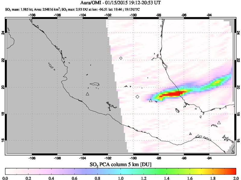 |
Figure 69. Sulfur dioxide plume from Popocatépetl on 15 January 2015 extending ENE from the summit over the Gulf of México. The gas is measured in Dobson Units (DU), the number of molecules in a square centimeter of the atmosphere. If you were to compress all of the sulfur dioxide in a column of the atmosphere into a flat layer at standard temperature and pressure (0° C and 1013.25 hPa), one Dobson Unit would be 0.01 millimeters thick and would contain 0.0285 grams of SO2 per square meter. The red pixels represent values >2 DU. Courtesy of NASA Goddard Space Flight Center (GSFC). |
The volcano was very active during February 2015. CENAPRED reported that their seismic network recorded several hundred low-intensity events that were accompanied by steam-and-gas-emissions and usually contained ash. Numerous explosions were attributed to lava-dome growth. Ash plumes rose 1-2 km above the crater, generally drifting NE. Ashfall was reported a number of times in communities up to 50 km away, and incandescence at the summit was observed on many nights.
On 11 February, ashfall was reported in the city of Puebla (~50 km to the E) and in the municipalities of Juan C. Bonilla (30 km ENE), Domingo Arenas (22 km NE), Huejotzingo (27 km NE), and at the airport to the E. On 15 February, explosions generated ashfall in Huejotzingo, Domingo Arenas, Salvador el Verde (30 km NNE), San Felipe Teotlalcingo (26 km NNE), and Puebla. Five explosions generated ash plumes on 18 February (figure 70). On 21 February, there were 22 small explosions, some of which ejected tephra 200 m onto the NE flank. A series of explosions on 24 February ejected incandescent material as far as 700 m onto the NE and SE flanks.
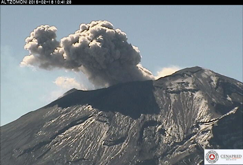 |
Figure 70. Ash explosion from Popocatépetl on 18 February 2015. Webcam image courtesy of CENAPRED. |
Additional explosions (19) detected on 25 February resulted in ashfall 20-37 km to the NE in San Martín Texmelucan (35 km NE), San Matías Tlalancaleca (35 km NE), San Salvador el Verde (29 km NE), Santa Rita Tlahuapan (34 km NNE), Tlaltenango, Huejotzingo, San Miguel Xoxtla (37 km NE), Domingo Arenas, Santa María Atexcac (20 km NE), and the Puebla airport (30 km NE). Explosions on 26 February ejected incandescent tephra 700 m onto the N and NE flanks; ashfall was again noted in Domingo Arenas, San Martín Texmelucan, and Huejotzingo in the state of Puebla. The international airport in Huejotzingo suspended operations to clean up the ash. On 27 February explosions generated ash emissions and again ejected incandescent tephra 300 m onto the flanks. Ashfall was reported in Huejotzingo, Domingo Arenas, Tlaltenango, San Andrés Cholula (33 km E), and Puebla. Two separate series of explosions were detected on 28 February, and more incandescent tephra was ejected 300 m onto the flanks.
During an overflight on 17 February, volcanologists observed a dome at the bottom of the inner crater, which formed in July 2013 and extends 100 m below the floor of the main crater. They identified this as dome number 55; it was 150 in diameter. On a second overflight on 27 February, volcanologists observed that the dome had grown and was filling the bottom of the inner crater (figure 71). The dome was 250 m in diameter and at least 40 m high, putting the top about 60 m above the bottom of the main crater floor. The volume was an estimated 1.96 million cubic meters. They also witnessed a small ash explosion from the inner crater (figure 71).
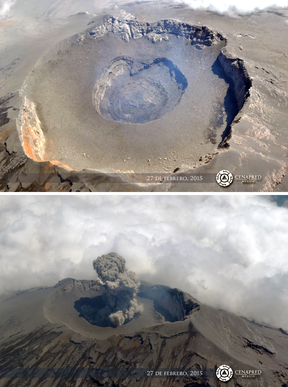 |
Figure 71. The summit crater with dome 55 at Popocatépetl on 27 February 2015. The dome at the bottom of the inner crater was estimated to be 250 m in diameter and at least 40 m high (upper). CENAPRED scientists witnessed a small ash explosion from the inner crater during the overflight (lower). Courtesy of CENAPRED. |
The Washington VAAC issued reports of ash emissions on 3 February, and during 11-16 and 24-28 February. Ash plumes identified in satellite imagery rose to altitudes of 6.1-6.7 km during 11-13 February and drifted as far as 5 km NE. On 24 February, a plume was seen extending about 15 km ENE from the summit at 6.7 km altitude. The next day an ash plume was observed in satellite imagery at 9.1 km altitude extending NE about 12 km from the summit. Later that day (25 February) it extended 300 km NE at 6.7 km altitude, out over the Gulf of México, before it dissipated. Additional emissions on 25 February occurred about every 60-90 minutes and drifted 130 km ENE at 8.2 km altitude. These bursts of ash continued moving ENE and finally dissipated about 170 km from the volcano. Plumes observed on 27 and 28 February in multispectral satellite images rose to 7-7.9 km altitude. A small area of faint ash from the 27 February emission was visible in images in the Gulf of México about 390 ENE of the summit late on 28 February, while a new emission was visible extending NE about 25 km. Twenty-five MODVOLC thermal alerts were issued most days during February (except 12-17). The OMI instrument on the AURA satellite captured 14 days of SO2 emissions with DU>2.
Activity continued at a high rate during March 2015, again with hundreds of emission events with gas, steam, and small quantities of ash (figure 72). Larger quantities of ash from multiple-per-week explosions rose 1-3 km above the summit and drifted N or NE. Incandescent tephra was ejected 100-800 m onto the N, NE, and SE flanks at least four times. A series of explosions on 7 March led to ashfall reported in Ecatzingo (15 km SW). On 9 March ashfall was reported in Amecameca (20 km NW), Ecatzingo (15 km SW), and Tepextlipa from explosions the previous day. A four-hour series of explosions on 24 March produced steam, gas, and ash emissions that rose 3 km.
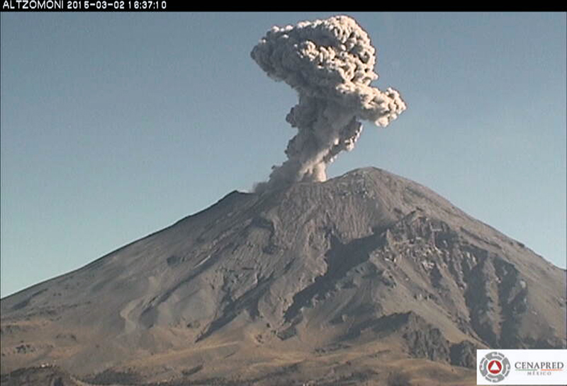 |
Figure 72. Ash emission from Popocatépetl on 2 March 2015. Webcam image courtesy of CENAPRED. |
The Washington VAAC reported ash emissions every day during 1-5, 7-10, 19-21, and 24-26 March. During the first week, the plumes rose 6.1-7.6 km altitude, drifted NE, N, and NW, and were usually visible for about 100 km from the summit before dissipating. On 8 March, two plumes drifted in opposite directions: one went 15 km ENE at 7 km altitude and one drifted 45 km W at 5.6 km altitude. During the second half of March, the plumes drifted generally NE, at altitudes of 6.1-7.3 km, tens of kilometers before dissipating. Only 11 MODVOLC thermal alerts were issued in March; SO2 data showed four days with DU>2, although SO2 plumes were visible in satellite data almost every day.
Hundreds of daily ash emissions were noted by CENAPRED during April 2015. Ash plumes generally drifted N or NE at 1-3 km above the summit crater, but occasionally they drifted W or SW. Incandescence was often noted at night. Incandescent tephra was ejected several hundred meters onto the flanks during 4-6 April, and again on 18 and 20 April. The only ashfall reported during the month was in Tetela and Ocuituco (both about 22 km SW) after ash-bearing explosions during 3-4 April.
During an overflight on 10 April (figure 73), scientists confirmed that a lava dome had been emplaced in the bottom of the crater between 24 March and 4 April. The lava dome was at least 250 m in diameter and 30 m high. The surface of the dome had concentric fractures and the central part was collapsed from deflation.
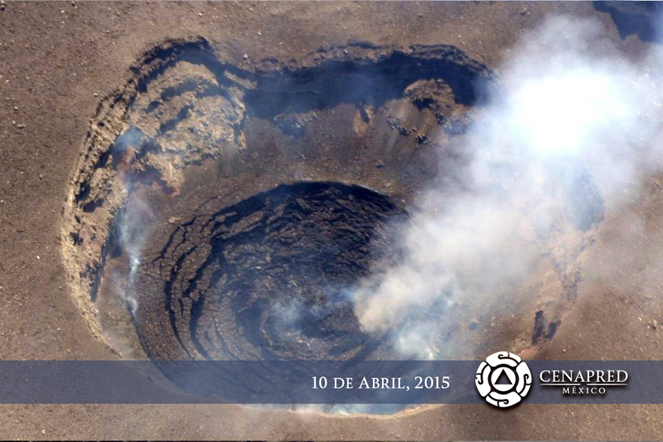 |
Figure 73. During an overflight on 10 April 2015, CENAPRED scientists confirmed that a lava dome had been emplaced in the bottom of the inner summit crater at Popocatépetl between 24 March and 4 April. Courtesy of CENAPRED. |
The Washington VAAC issued aviation alerts during 1, 3-8, 13, and 18-21 April. On 3 April volcanic ash was observed moving SE from the summit at 8.2 km altitude. The plume extended over 150 km before dissipating later in the day. Another plume the same day rose to 9.1 km altitude and drifted 55 km NE. During 4 and 5 April, ongoing emissions at various altitudes from 6.1 to 9.1 km drifted in multiple directions for tens of kilometers before dissipating. Most of the alerts were for brief, intermittent emissions that dissipated within 20 km of the summit after a few hours. On 7 April one ash cloud drifted 45 km SSE and another drifted 100 km SE, both at 7.6 km altitude. An ash emission on 13 April traveled around 260 km E at 7.3 km altitude before dissipating. The plumes observed during 18-21 April ranged from 6.7 to 9.7 km in altitude, and mostly drifted NE or E. There were 20 MODVOLC thermal alerts issued during April, scattered throughout the month. Most days during April had SO2 plumes with values >2 DU in the satellite data.
Ashfall was reported in San Pedro Benito Juárez (10-12 km SE), in the municipality of Atlixco Puebla on 2 May 2015, and in Ocuituco (24 km SW) on 22 May. On 26 May ashfall was reported in Tetela del Volcán (20 km SW) and slight ashfall was recorded in Amozoc, Puebla (60 km E) on 31 May. The ongoing explosions generated ash emissions that generally rose 0.5-2.5 km above the crater rim and sent plumes to the SW, SE, and E (figure 74). Nighttime crater incandescence was observed on most clear nights.
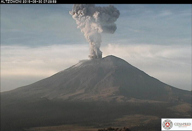 |
Figure 74. Ash emission at Popocatépetl on 30 May 2015. Webcam image courtesy of CENAPRED. |
Although aviation alerts from the Washington VAAC were issued during 9 days of May (2, 10, 20-21, 25-26, 28, and 30-31), plumes were only visible in satellite images a few times. The highest plume was on 20 May, at 8.2 km altitude drifting SSW. The plume on 26 May was observed drifting NW at 6.1 km, extending 150 km from the summit. Only four MODVOLC thermal alerts were issued during 10, 19, 21 and 30 May, but strong SO2 plumes (>2 DU values) were recorded 12 times, with just as many days showing smaller-magnitude plumes.
Activity was much quieter at Popocatépetl during June 2015. Only six VAAC reports were issued (during 7-8, 12, and 21-22), and only two were identified in satellite images. The plume on 7 June rose to 8.2 km altitude and drifted SW. The larger plume on 12 June came from multiple small emissions; it rose to 6.1 km altitude and was last seen at 55 km SW of the summit before dissipating. There were seven MODVOLC thermal alerts on seven different days during June, and 17 different days with SO2 plumes with recorded values >2 Dobson Units.
Activity during July-December 2015. Multiple daily emissions, nighttime incandescence, and intermittent explosions continued during July 2015 (figure 75). Nine MODVOLC thermal alerts were issued, but they were concentrated during 6-8 and 26-31 July. The Washington VAAC issued alerts on 8, 10, and 11 July, and then during a second period from 24 to 28 July. The report on 8 July noted an ash emission at 7.6 km altitude extending 15 km SW from the summit. The report on 10 July noted that ashfall had been reported about 10 km NW of the summit, but cloudy skies prevented satellite observations. Reports issued during 24-28 July included satellite observations of emissions at 6.1 to 7.6 km altitude extending 25-45 km NE or W from the summit before dissipating. The SO2 emissions during July were visible nearly every day in the satellite data, with 16 days having values >2 DU.
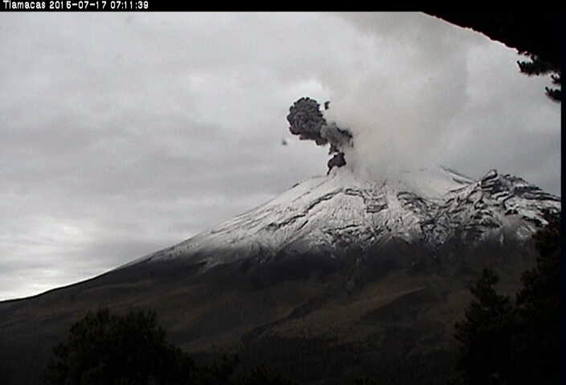 |
Figure 75. Ash emission on 17 July 2015 from Popocatépetl. Webcam image courtesy of CENAPRED. |
Sulfur dioxide emissions during August 2015 were also visible in satellite imagery nearly every day. Six days had values >2 DU. There were no Washington VAAC reports during August, but there were ten MODVOLC thermal alerts issued throughout the month.
The number of daily emissions during September 2015 were far fewer than during January-July 2015, although crater incandescence was still observed. The Washington VAAC only issued three reports, all during 19-20 September. They observed an ash emission on 19 September at 6.7 km altitude that extended 45 km WNW from the summit for a few hours before dissipating (figure 76). Ten MODVOLC thermal alerts were issued in September, and SO2 plumes were visible daily with values >2 DU on half the days of the month.
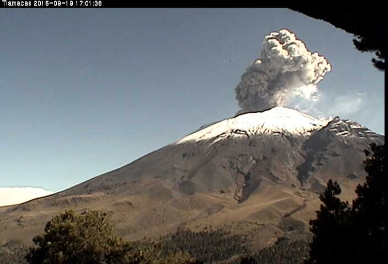 |
Figure 76. Ash emission from Popocatépetl on 19 September 2015. Webcam image courtesy of CENAPRED. |
Ash emissions increased again during October 2015. Ash-bearing plumes rose as high as 2 km above the crater. The Washington VAAC issued reports of ash plumes on 12 different days. An ash plume observed on 2 October at 7.6 km altitude extended 185 km SW before dissipating; another plume on 20 October was identified in satellite images at 8.5 km altitude drifting NW, and was visible from México City. Eighteen MODVOLC thermal alerts were issued throughout the month, and strong SO2 plumes were detected nearly every day in OMI satellite data.
Activity during November 2015 was similar to that during October. CENAPRED recorded tens of daily emissions of water vapor, gas, and minor amounts of ash. Explosions at regular intervals sent ash plumes 1-3 km above the summit, and incandescent material was deposited on the flanks within 1 km of the crater a number of times (figure 77). The Washington VAAC issued aviation alerts almost daily during 1-17 November, but none after that for the rest of the year. Most of the ash plumes reached 6.1-7.3 km altitude and drifted N, NE, SW, W, and S for a few tens of kilometers before dissipating. The plume on 7 November rose to 9.1 km and was visible as a dark feature above the weather clouds before it dissipated.
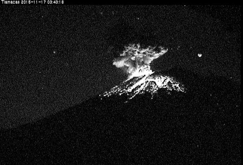 |
Figure 77. Incandescent material showers the flanks of Popocatépetl from an explosion during the early morning hours of 17 November 2015. Webcam image courtesy of CENAPRED. |
While ash plume observations decreased during the second half of November and during December, MODVOLC thermal alerts increased in number. Thirty-three appeared during November, and 35 during December. Plumes of SO2 were persistently visible in Aura/OMI satellite data both months.
Activity during January-June 2016. A series of explosive events during 2-8 January 2016 resulted in 13 aviation alerts from the Washington VAAC. An ash plume first reported in satellite data early on 6 January was drifting E at 6.4 km altitude. By late the next day, VAAC reports indicated that the plume was still visible over 1,000 km E before it finally dissipated. A new series of explosive events began on 20 January (figure 78) and lasted through 26 January.
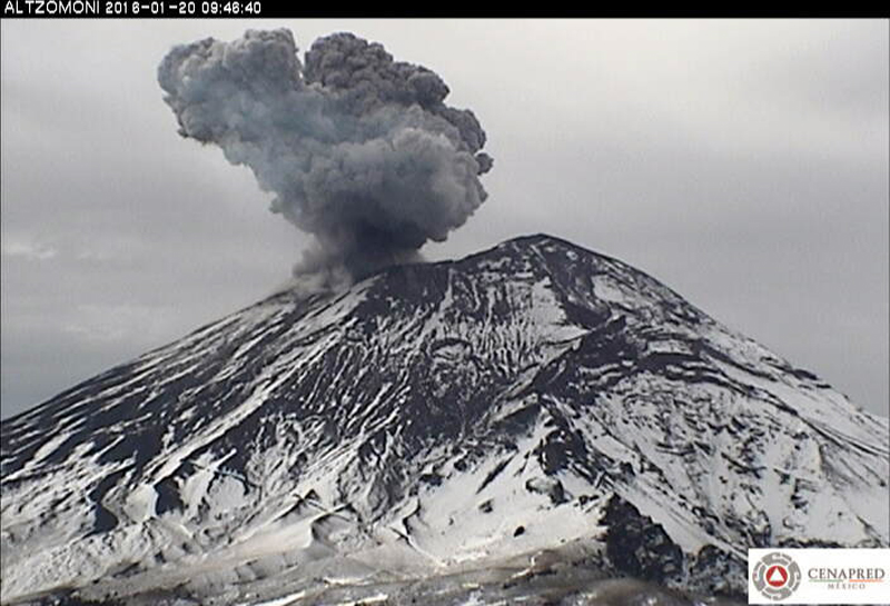 |
Figure 78. Ash explosion at Popocatépetl on 20 January 2016. Webcam image courtesy of CENAPRED. |
CENAPRED reported that on 23 January 2016 an increase in activity was characterized by continuous gas-and-ash emissions, likely related to the destruction of a recently-formed lava dome. Later that night cameras recorded incandescent fragments ejected during periods of emissions. The constant steam-and-ash emissions drifted E and ENE for more than 48 hours at altitudes from 6.1 to 8.2 km. By 25 January, an ash plume was still visible over 900 km E. NASA Earth Observatory posted a satellite image of the plume around 1930 UTC (1330 local time) (figure 79). NASA's Goddard Space Flight Center also captured an image of a strong SO2 plume drifting NE from Popocatépetl at the same time (figure 80). Twenty-six MODVOLC thermal alerts were issued on 15 days of January. Especially strong SO2 plumes were visible on 6, 7, 23, and 25 January.
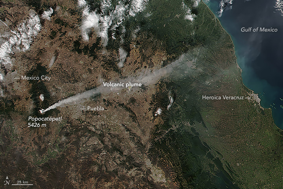 |
Figure 79. Popocatépetl emits an ash plume on 25 January 2016 that extends over 300 km E over the Gulf of México. The Visible Infrared Imaging Radiometer Suite (VIIRS) on the Suomi NPP satellite captured this image at 1930. Image prepared by Jeff Schmaltz, LANCE/EOSDIS Rapid Response using VIIRS data from the Suomi National Polar-orbiting Partnership. Suomi NPP is the result of a partnership between NASA, the National Oceanic and Atmospheric Administration, and the Department of Defense. Courtesy of NASA Earth Observatory. |
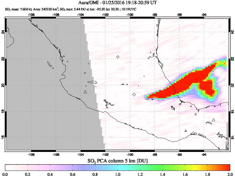 |
Figure 80. A strong SO2 plume drifting over 500 km NE from Popocatépetl was captured by the OMI instrument on the AURA satellite during 1918-2015 UTC on 25 January 2016. A visible infrared image was acquired within this same period (see figure 79). Courtesy of NASA GSFC. |
Tens of daily emissions of water vapor, gas, and ash were reported during February 2016, along with multiple daily explosions generating ash plumes and occasionally sending tephra onto the flank. The Washington VAAC issued aviation alerts on twelve days during the month. They were discrete events that sent ash plumes generally E or SE at altitudes between 6 and 7 km, and generally dissipated within 6 hours, tens of kilometers from the summit. An ash plume reported on 15 February was still visible 500 km E of the summit before it dissipated. MODVOLC thermal alerts were reported on 10 days during the month, SO2 plumes were more intermittent and only exceeded 2 DU on four days.
The largest ash explosion events during March 2016 took place at the end of the month. On 27 March, an ash plume was spotted by the Washington VAAC extending about 100 km NE at 6.4 km altitude. Explosions on 29 March created an ash plume at 9.1 km altitude moving rapidly ESE (figure 81). Ashfall from the plume caused Puebla's airport to close from 2000 on 29 March to 0600 on 30 March. The plume fanned out and extended tens of kilometers to both the S and SE before dissipating. On 31 March an explosion produced an ash plume that rose 1.8 km and drifted ENE; incandescent fragments fell 1 km away on the ESE flank. Thermal alerts were issued by MODVOLC on 13 days of March, and SO2 plumes were visible about the same number of days, but values did not exceed 2 DU.
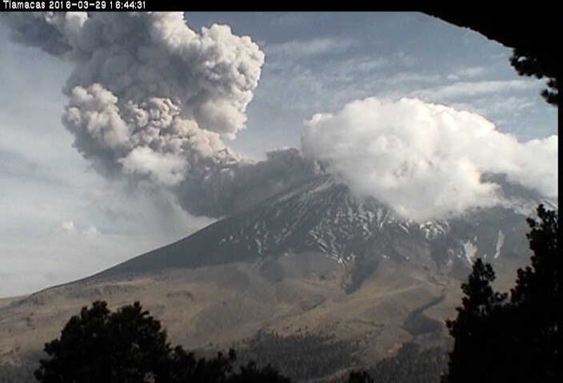 |
Figure 81. An ash plume at Popocatépetl on 29 March 2016. Webcam image courtesy of CENAPRED. |
On 2 April 2016 CENAPRED scientists conducted an overflight of the crater and observed the inner crater which was 325 m in diameter and 50 m deep (figure 82). The crater had previously been filled with a lava dome, destroyed in January, which had grown to an estimated volume of 2,000,000 cubic meters. Small landslides had occurred on the E wall of the inner crater. During 3 April, incandescent fragments were ejected as far as 3.5 km onto the E and SE flanks, generating fires in that part of the forest; authorities noted that the event was the largest explosion in three years. Ash fell in the towns of Juan C. Bonilla (32 km ENE) and Coronango (35 km ENE), both in the state of Puebla. The Washington VAAC reported numerous ash plumes during 1-9 April. The highest, on 1 April, was observed in satellite data at 9.7 km altitude, extending over 300 km NE over the Gulf of México. The other plumes were mostly observed between 6.4 and 8.5 km altitude, drifting E or NE.
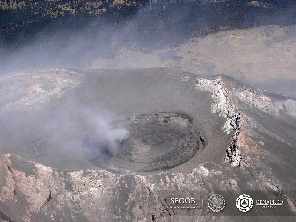 |
Figure 82. The inner crater at Popocatépetl on 2 April 2016. CENAPRED scientists estimated that it was 325 m in diameter and 50 m deep. The previous lava dome was destroyed during January 2016. Courtesy of CENAPRED. |
Strombolian activity on 18 April ejected incandescent fragments 1.6 km onto the NE flank, and ash plumes rose 3 km above the crater and drifted ENE. Ashfall was reported in San Pedro Benito Juárez (12 km SE), San Nicolás de los Ranchos (15 km ENE), Tianguismanalco (17 km E), San Martín Texmelucan (35 km NNE), and Huejotzingo (27 km NE). According to a news article, the airport in Puebla closed again due to the ash plumes. Thermal alerts from MODVOLC were recorded on 13 days during the month, and SO2 plumes were visible in the Aura/OMI data almost every day.
Activity continued at slightly lower levels during May 2016 with VAAC reports issued on nine days. The ash plumes reported all dissipated quickly within a few tens of kilometers of the summit after drifting E at altitudes generally around 6.4 to 6.7 km. Single MODVOLC alerts were reported on only six days during the month, and except for a large SO2 plume on 3 May, small plumes were visible about 8 days of the month.
An increase in the number of daily explosions with ash emissions was reported by CENAPRED during June 2016. As many as six a day were reported during the second week of the month. An explosion on 12 June produced an ash plume that rose 2.5 km and drifted W (figure 83). Minor amounts of ash fell in Ozumba (18 km W). Aviation alerts were issued by the Washington VAAC on 13 days. Most of the ash plumes dissipated within six hours a few tens of kilometers from the summit due to high winds. The plumes rose to altitudes between 6.1 and 7.9 km, and drifted NE, W and SW. The ash plume reported on 23 June extended NE 16 km at 7.3 km altitude, and 26 km SW at 5.8 km altitude simultaneously. Thermal alerts from the MODVOLC system were reported on 1, 8, and 25 June. SO2 satellite data was only available for the second half of the month, and showed two days with significant SO2 plumes.
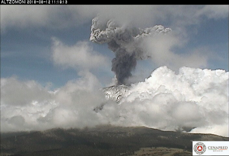 |
Figure 83. Explosion with ash plume at Popocatépetl on 12 June 2016. Webcam image courtesy of CENAPRED. |
Geological Summary. Volcán Popocatépetl, whose name is the Aztec word for smoking mountain, rises 70 km SE of Mexico City to form North America's 2nd-highest volcano. The glacier-clad stratovolcano contains a steep-walled, 400 x 600 m wide crater. The generally symmetrical volcano is modified by the sharp-peaked Ventorrillo on the NW, a remnant of an earlier volcano. At least three previous major cones were destroyed by gravitational failure during the Pleistocene, producing massive debris-avalanche deposits covering broad areas to the south. The modern volcano was constructed south of the late-Pleistocene to Holocene El Fraile cone. Three major Plinian eruptions, the most recent of which took place about 800 CE, have occurred since the mid-Holocene, accompanied by pyroclastic flows and voluminous lahars that swept basins below the volcano. Frequent historical eruptions, first recorded in Aztec codices, have occurred since Pre-Columbian time.
Information Contacts: Centro Nacional de Prevención de Desastres (CENAPRED), Av. Delfín Madrigal No.665. Coyoacan, México D.F. 04360, México (URL: https://www.gob.mx/cenapred/); Washington Volcanic Ash Advisory Center (VAAC), Satellite Analysis Branch (SAB), NOAA/NESDIS OSPO, NOAA Science Center Room 401, 5200 Auth Rd, Camp Springs, MD 20746, USA (URL: http://www.ospo.noaa.gov/Products/atmosphere/vaac/, archive at: http://www.ssd.noaa.gov/VAAC/archive.html); Hawai'i Institute of Geophysics and Planetology (HIGP), MODVOLC Thermal Alerts System, School of Ocean and Earth Science and Technology (SOEST), Univ. of Hawai'i, 2525 Correa Road, Honolulu, HI 96822, USA (URL: http://modis.higp.hawaii.edu/); NASA Earth Observatory, EOS Project Science Office, NASA Goddard Space Flight Center, Goddard, Maryland, USA (URL: http://earthobservatory.nasa.gov/); NASA Goddard Space Flight Center (NASA/GSFC), Global Sulfur Dioxide Monitoring Page, Atmospheric Chemistry and Dynamics Laboratory, 8800 Greenbelt Road, Goddard, Maryland, USA (URL: https://so2.gsfc.nasa.gov/).