Report on Santa Maria (Guatemala) — July 2017

Bulletin of the Global Volcanism Network, vol. 42, no. 7 (July 2017)
Managing Editor: Edward Venzke.
Edited by A. Elizabeth Crafford.
Santa Maria (Guatemala) Continuous ash emissions, pyroclastic flows and lahars; new lava dome visible at Caliente dome, October 2016
Please cite this report as:
Global Volcanism Program, 2017. Report on Santa Maria (Guatemala) (Crafford, A.E., and Venzke, E., eds.). Bulletin of the Global Volcanism Network, 42:7. Smithsonian Institution. https://doi.org/10.5479/si.GVP.BGVN201707-342030
Santa Maria
Guatemala
14.757°N, 91.552°W; summit elev. 3745 m
All times are local (unless otherwise noted)
The dacitic Santiaguito lava-dome complex on the W flank of Guatemala's Santa María volcano has been growing since 1922. The youngest of the four vents in the complex, Caliente, has been actively erupting with ash explosions, pyroclastic flows, and lava flows for more than 40 years. Constant steam and magmatic gases during January-June 2016 were accompanied by some of the largest explosive events of the last few years in April and May. Ash plumes rose to over 5 km altitude and spread ash regularly over communities within 30 km (BGVN 41:09). Guatemala's INSIVUMEH (Instituto Nacional de Sismologia, Vulcanologia, Meterologia e Hidrologia) and the Washington VAAC (Volcanic Ash Advisory Center) provided regular updates on the continuing activity during the second half of 2016, and are the primary sources of information for this report.
Constant emission of both steam and magmatic gas were observed from the summit of Caliente dome throughout July-December 2016. Overall, eruptive activity decreased during this period compared with the previous six months. During July-September, INSIVUMEH reported 3-5 daily weak or moderate explosions with ash plumes that rose to 3.3-3.5 km altitude and dispersed ash over communities generally to the SW within 30 km. Stronger explosions took place 5-10 times each month from July-September. The ash plumes from these larger explosions usually rose to 5-5.5 km altitude. The highest plume was reported by the Washington VAAC at 6.1 km altitude during August. Ash plumes drifted more than 100 km from the volcano on several occasions, and ashfall was reported more than 50 km away more than once. These larger explosions also produced numerous pyroclastic flows that descended into the drainages on the SE, S, and SW flanks of Caliente dome. Heavy rains resulted in substantial lahars generated from the ash and debris several times each month.
INSIVUMEH observed the growth of a new lava dome inside the summit crater of Caliente beginning in October. By the end of the year, it had filled more than half of the summit crater with new material. During October, November, and the first part of December, the number of smaller explosions to around 3.5 km altitude increased to 25-35 daily events.
Activity during July-August 2016. Eruptive activity at the Santiaguito dome complex decreased from previous months during July 2016. Constant degassing from the Caliente dome, weak and moderate daily explosions, and ashfall in nearby (5-20 km) communities to the W and SW were typical. Steam and magmatic gases generally rose 300-400 m above the summit crater. Three or four weak to moderate explosions per day generally created diffuse ash plumes that rose to altitudes of 3.3-3.5 km. Ashfall from the smaller explosions generally affected the villages of San Marcos Palajunoj, Loma Linda, Monte Bello, and a few others located 10-20 km SW. Four stronger explosions on 1 (2), 3, and 10 July sent ash plumes to altitudes of 5-5.5 km (figure 48) and generated pyroclastic flows that descended the SW, S, and SE flanks (figure 49).
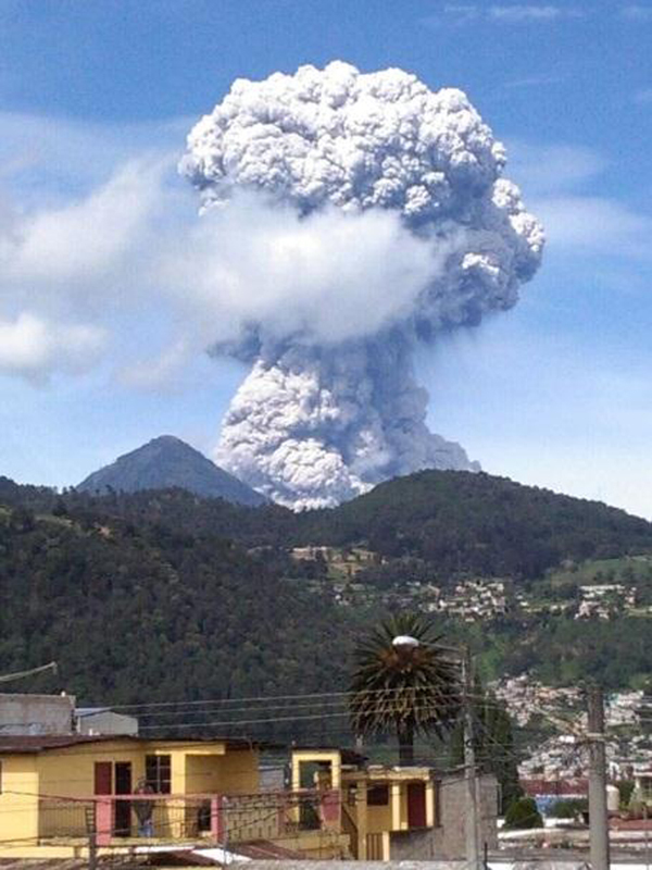 |
Figure 48. A strong explosion with a mushroom-cloud-shaped ash plume rising to 5.5 km on 1 July 2016 at Santa María. View is from the NW. Courtesy of INSIVUMEH (Informe Mensual de Actividad Volcánica, Julio 2016). |
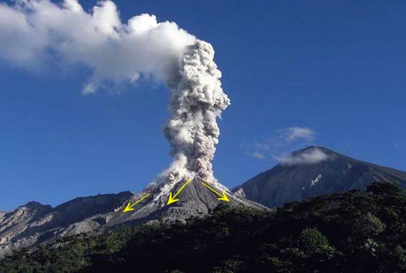 |
Figure 49. A strong explosion with pyroclastic flows traveling down the SW, S, and SE flanks of Caliente dome at Santa María during July 2016. View is from the SE. Courtesy of INSIVUMEH (Informe Mensual de Actividad Volcánica, Julio 2016). |
Ash from the larger explosions was reported at least once in Columba, about 20 km SW (figure 50), Malacatán (about 55 km NW), and also from the Chiapas regions of Mexico, 70 km W. The Washington VAAC reported a plume on 1 July at 5.2 km altitude with ash extending about 35 km WNW. On 10 July, they observed an ash plume in multispectral imagery moving NW about 45 km from the summit. They also observed a bright hotspot at the summit. On 11 July, they reported an ash plume at 6.4 km altitude extending over 80 km NW. Dissipating ash was visible in imagery about 275 km NW later in the day.
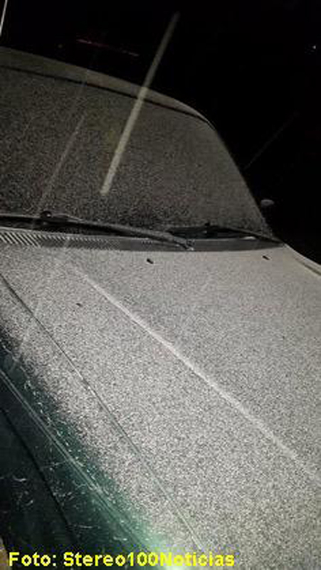 |
Figure 50. Ash fall covered vehicles in Colomba, about 20 km SW, from one of the larger explosions at Santa María during July 2016. Courtesy of INSIVUMEH (Informe Mensual de Actividad Volcánica, Julio 2016). |
A lahar descended the Cabello de Ángel river drainage on 3 July 2016 after a large explosion (figure 51). It was up to 30 m wide in places, and 1.5 m deep with blocks up to 1.5 m in diameter. The Cabello de Ángel flows into the Nimá I and Samala River drainages.
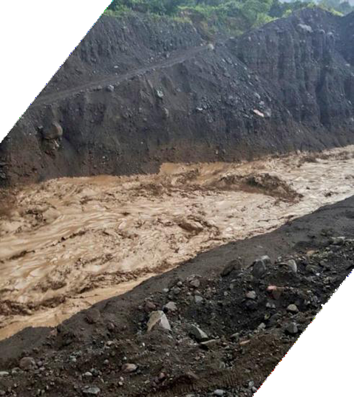 |
Figure 51. A lahar descends the Nimá I drainage on 3 July 2016 at Santa María after a large explosion created a pyroclastic flow down the S flank. Courtesy of INSIVUMEH (Informe Mensual de Actividad Volcánica, Julio 2016). |
Constant degassing of steam and bluish magmatic gases continued during August 2016, rising 100-400 m above the summit of Caliente dome. Three to five weak or moderate explosions occurred daily, sending ash plumes to altitudes of 3.3-3.5 km (800-1,000 m above the dome). The STG3 seismic station recorded nine larger explosions in August (4, 14, 16, 18, 20, 21, 23, 28) that sent ash emissions to 4-5.5 km altitude, and generated pyroclastic flows that descended up to 2.5 km down the flanks (figure 52). The incandescent rock and ash descended the Nimá I, Nimá II, and San Isidro drainages on the SW, S, and SE flanks.
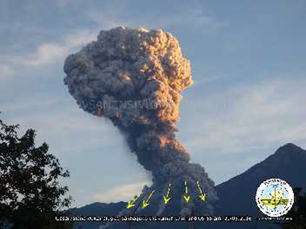 |
Figure 52. Pyroclastic flows descend several drainages on the S, SW, and SE flanks of Caliente at Santa María during one of the large explosions of August 2016. Courtesy of INSIVUMEH (Informe Mensual de Actividad Volcánica, Agosto 2016). |
Communities and fincas (farms) affected by ashfall from these explosions included San Marcos Palajunoj, Loma Linda, Monte Bello, San Felipe (15 km SSW), Mazatenango (25 km SSE), Retalhuleu (27 km SW), El Faro, La Florida (5 km S), Patzulin (SW flank), and El Patrocinio. Tephra particles as large as 8 mm were collected in Loma Linda (figure 53). A few of the explosions resulted in ashfall more than 50 km from the volcano, including into Mexico. The Washington VAAC reported ash plumes rising to 5.8 km on 1 August; they were later visible 175 km W of the Mexico coast, W of Tapachula, Mexico. Two emissions on 12 August were seen at 5.2 km altitude drifting W. Ongoing emissions were reported at 6.1 km altitude on 16 August moving WNW and extending about 80 km. The plume observed on 19 August was 65 km NW at 5.5 km altitude. A plume observed in multispectral imagery on 25 August was moving NW at 6.1 km altitude over 185 km from the summit.
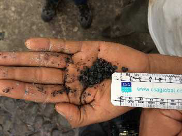 |
Figure 53. Lapilli fragments as large as 8 mm diameter were collected in Loma Linda on 16 August 2016 from an explosion at Santa María. Courtesy of INSIVUMEH (Informe Mensual de Actividad Volcánica, Agosto 2016). |
Increased precipitation during August 2016 led to lahars on 8, 13, and 29 August 2016 that descended the Cabello de Ángel , Nimá I, and Samalá drainages. They ranged from 18 to 25 m wide and were 1.5 m deep containing blocks up to 1.5 m in diameter. Flooding was reported downstream near the Castillo Armas bridge on the Samalá River.
Activity during September 2016. Most of the steam and magmatic gases emitting daily from Caliente during September 2016 rose 100-400 m above the dome and generally drifted SW or W (figure 54). Small to moderate ash-bearing explosions occurred 3-5 times daily; ash plumes generally rose to 3.3-3.5 km altitude during these events. Several stronger explosions during September (1, 4, 11, 17, 19, 24, 25, 30) generated ash plumes that rose to 4.5 or 5 km altitude and drifted W, SW, S, SE and E. The Washington VAAC also reported an ash plume observed in multispectral imagery on 20 September at 5.2 km altitude drifting 45 km W. A few hours later, they reported two plumes, one at 4.6 km drifting 75 mi W, and a second at 5.2 km altitude moving WSW over 80 km from the summit.
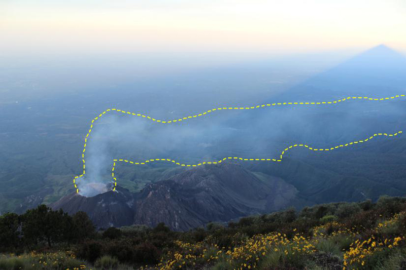 |
Figure 54. A magmatic gas plume drifts W from the Caliente dome in this view from the summit of Santa María during September 2016. Courtesy of INSIVUMEH (Informe Mensual de Actividad Volcánica, Septiembre 2016). |
Near-daily ashfall was reported from many of the communities 10-20 km SW including San Marcos Palajunoj, Loma Linda, Monte Bello, Santa María de Jesús, El Nuevo Palmar, and Las Marías (figure 55) during September 2016. Lapilli as large as 15 mm diameter was collected in the neighborhoods of San Marcos Palajunoj (figure 56).
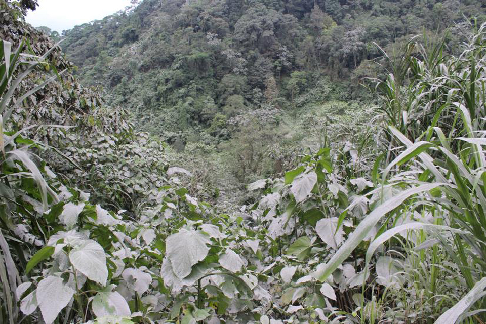 |
Figure 55. Vegetation near Loma Linda was covered with ash almost daily from Santa María during September 2016. Courtesy of INSIVUMEH (Informe Mensual de Actividad Volcánica, Septiembre 2016). |
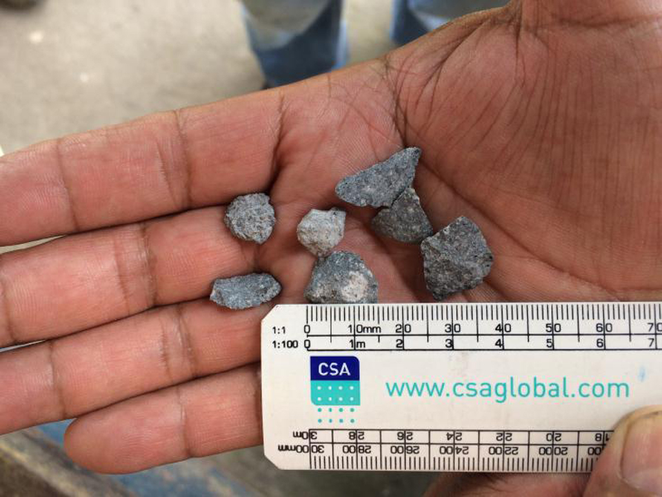 |
Figure 56. Lapilli from Santa María up to 15 mm in diameter fell in the village San Marcos Palajunoj during September 2016. Courtesy of INSIVUMEH (Informe Mensual de Actividad Volcánica, Septiembre 2016). |
The larger explosions also resulted in pyroclastic flows that travelled 2.0-2.5 km down the SW, S, and SE flanks in the Nimá I, Nimá II, and San Isidro drainages. Areas of vegetation burned from the heat of the pyroclastic flows (figure 57).
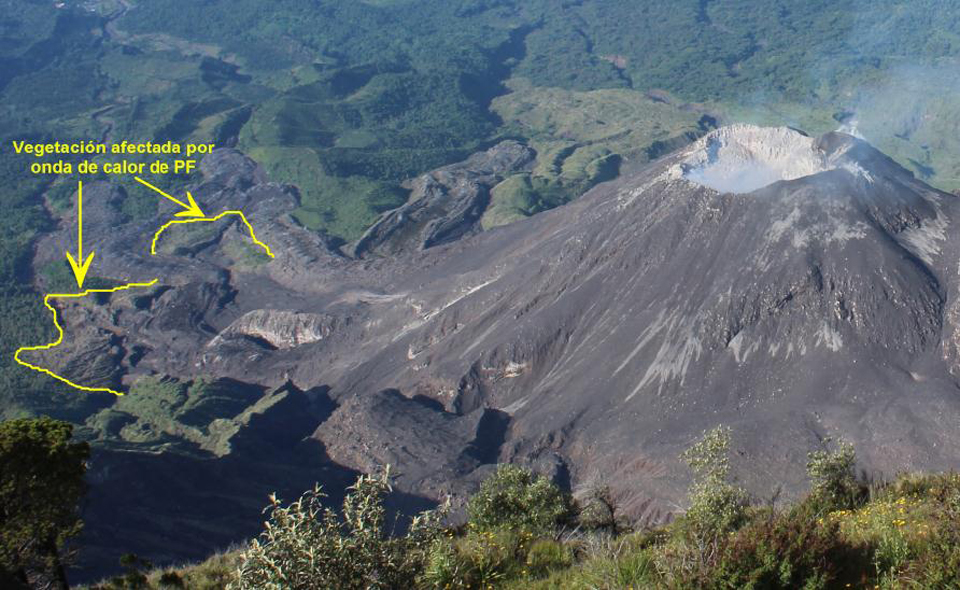 |
Figure 57. Several areas of burned vegetation from the pyroclastic flows that descended the drainages on the SE flank of Caliente dome at Santa María during September 2016 are highlighted in yellow. The view is from the summit of Santa María looking S. Courtesy of INSIVUMEH (Informe Mensual de Actividad Volcánica, Septiembre 2016). |
Lahars or heavy mudflows were recorded on ten days during September, primarily in the Cabello de Ángel and Nimá I drainages (figure 58). Channels of debris worked their way over the 2015 lava flows in the Nimá I drainage and continued downstream. The lahars were 13-20 m wide and 1.5 m high and carried clay, volcanic ash, and blocks up to 1.5 m in diameter.
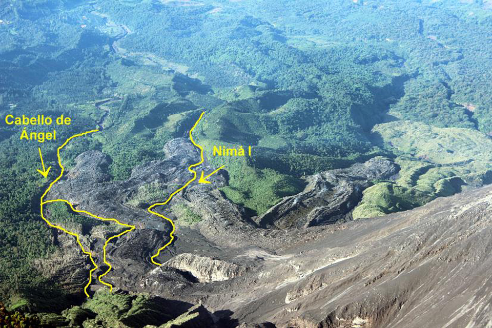 |
Figure 58. The active channels of the Cabello de Ángel and Nimá I drainages (in yellow) on the SE flank of the Caliente dome at Santa María hosted numerous pyroclastic flows and lahars. The many lahars of September 2016 traveled over parts of the channel covered by the 2015 lava flows in the Nimá I drainage. Courtesy of INSIVUMEH (Informe Mensual de Actividad Volcánica, Septiembre 2016). |
The constant explosive activity at Caliente dome during 2016 enlarged the summit crater significantly between January and the end of September 2016. In January 2016, it was about 260 m wide and 20 m deep; by 21 September, it was 340 m wide and 175 m deep according to INSIVUMEH (figure 59).
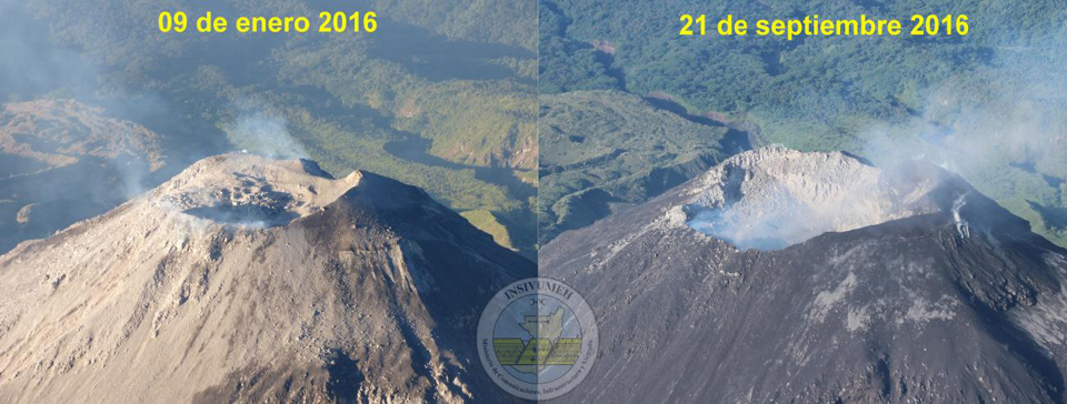 |
Figure 59. The summit crater at Santa María's Caliente dome enlarged substantially between 9 January (left) and 21 September (right) 2016 from numerous explosions. In January 2016, it was about 260 m wide and 20 m deep; by 21 September, it was 340 m wide and 175 m deep. Courtesy of INSIVUMEH (Informe Mensual de Actividad Volcánica, Septiembre 2016). |
Activity during October-December 2016. INSIVUMEH reported that a new lava dome began growing inside the summit crater of Caliente on 1 October 2016. The number of weak to moderate ash-bearing explosions increased during October, but the overall amount of energy from the explosions decreased. The STG3 seismic station recorded 25-35 weak to moderate explosions per day and the ash plumes they created generally rose to 3.3-3.5 km altitude (figure 60). There were no strong explosions reported by INSIVUMEH. The Washington VAAC reported larger ash plumes at 5.5 km altitude on 3 and 4 October that drifted a few tens of kilometers SSW from the summit before dissipating. Ashfall from these plumes was reported in the villages of San Marcos Palajunoj, Loma Linda, Monte Bello, El Faro, Patzulin and others to the S and SW. Lahars up to 20 m wide descended the Cabello de Ángel drainage on 4, 27, and 28 October.
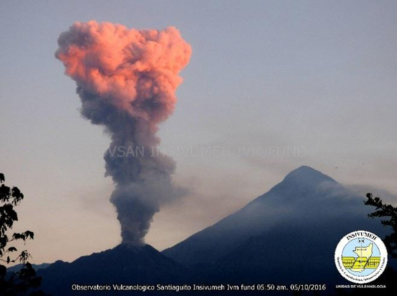 |
Figure 60. An ash-bearing emission from the Caliente dome at Santa María on 5 October 2016 rises into the sunset glow. The plume rose to an altitude of about 3.5 km before drifting SW. View from the SE. Courtesy of INSIVUMEH (Informe Mensual de Actividad Volcánica, Octubre 2016). |
The same eruptive pattern as October continued during November 2016 with 25-35 daily weak to moderate explosions that were responsible for ashfall in the villages to the SW, including Monte Claro, San José, and La Quinta and others. Steam and magmatic gasses continued to rise 100-500 m above the Caliente dome. A 15-m-wide lahar descended the Cabello de Ángel drainage on 9 November that was one meter deep, and carried material several kilometers down the Nimá and Samala drainages. The Washington VAAC reported some of the ash plumes visible up to 50 km from the dome. On 14 November, they noted two ash emissions at 4.6 km altitude. One was dissipating about 40 km SW while the second was within 15 km headed in the same direction. They also noted a small ash emission at 4.6 km altitude on 25 November drifting 20 km W.
Eruptive activity continued at a similar level during the first half of December 2016 with many weak and a few moderate explosions. During the second half of the month, the number of moderate explosions increased, but the overall number of explosions decreased. Twenty-five to thirty weak to moderate explosions per day were responsible for ash plumes rising to 3.0-3.5 km altitude. The Washington VAAC reported plumes on 24 and 30 December visible in satellite imagery at 4.6 km altitude drifting W. INSIVUMEH reported that the explosion on 30 December generated a pyroclastic flow that traveled for 2 km.
The growth of the new lava dome within the summit crater of Caliente first observed in October continued during November and December. By 18 December 2016 the new, growing dome had filled about two-thirds of the summit crater (figure 61). Heat flow at Caliente steadily declined during the second half of 2016, especially as compared with values during the first half of the year (see figure 47, BGVN (41:09). Only two MODVOLC thermal alerts were recorded after June 2016, on 29 July and 1 August. The MIROVA signal also showed a steady decrease in heat flow during this period (figure 62).
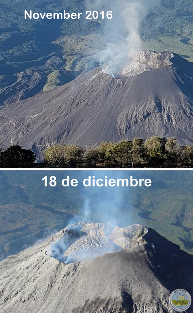 |
Figure 61. Growth of the new lava dome at the summit crater of Caliente dome at Santa María during November and December 2016. The upper image was taken by Barbara Garcia during November 2016. The lower image is dated 18 December 2016. Courtesy of INSIVUMEH (Informe Mensual de Actividad Volcánica, Noviembre and Diciembre 2016). |
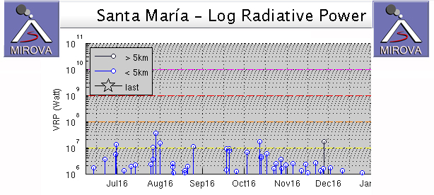 |
Figure 62. MIROVA graph of Log Radiative Power from Santa María from early June through December 2016 shows steadily declining heat flow. Courtesy of MIROVA. |
Geological Summary. Symmetrical, forest-covered Santa María volcano is part of a chain of large stratovolcanoes that rise above the Pacific coastal plain of Guatemala. The sharp-topped, conical profile is cut on the SW flank by a 1.5-km-wide crater. The oval-shaped crater extends from just below the summit to the lower flank, and was formed during a catastrophic eruption in 1902. The renowned Plinian eruption of 1902 that devastated much of SW Guatemala followed a long repose period after construction of the large basaltic andesite stratovolcano. The massive dacitic Santiaguito lava-dome complex has been growing at the base of the 1902 crater since 1922. Compound dome growth at Santiaguito has occurred episodically from four vents, with activity progressing E towards the most recent, Caliente. Dome growth has been accompanied by almost continuous minor explosions, with periodic lava extrusion, larger explosions, pyroclastic flows, and lahars.
Information Contacts: Instituto Nacional de Sismologia, Vulcanologia, Meteorologia e Hydrologia (INSIVUMEH), Unit of Volcanology, Geologic Department of Investigation and Services, 7a Av. 14-57, Zona 13, Guatemala City, Guatemala (URL: http://www.insivumeh.gob.gt/); Washington Volcanic Ash Advisory Center (VAAC), Satellite Analysis Branch (SAB), NOAA/NESDIS OSPO, NOAA Science Center Room 401, 5200 Auth Rd, Camp Springs, MD 20746, USA (URL: http://www.ospo.noaa.gov/Products/atmosphere/vaac/, archive at: http://www.ssd.noaa.gov/VAAC/archive.html); Hawai'i Institute of Geophysics and Planetology (HIGP) - MODVOLC Thermal Alerts System, School of Ocean and Earth Science and Technology (SOEST), Univ. of Hawai'i, 2525 Correa Road, Honolulu, HI 96822, USA (URL: http://modis.higp.hawaii.edu/); MIROVA (Middle InfraRed Observation of Volcanic Activity), a collaborative project between the Universities of Turin and Florence (Italy) supported by the Centre for Volcanic Risk of the Italian Civil Protection Department (URL: http://www.mirovaweb.it/).