Report on San Miguel (El Salvador) — July 2017
Bulletin of the Global Volcanism Network, vol. 42, no. 7 (July 2017)
Managing Editor: Edward Venzke.
Edited by A. Elizabeth Crafford.
San Miguel (El Salvador) Six small ash emission events during January 2015-June 2017
Please cite this report as:
Global Volcanism Program, 2017. Report on San Miguel (El Salvador) (Crafford, A.E., and Venzke, E., eds.). Bulletin of the Global Volcanism Network, 42:7. Smithsonian Institution. https://doi.org/10.5479/si.GVP.BGVN201707-343100
San Miguel
El Salvador
13.434°N, 88.269°W; summit elev. 2130 m
All times are local (unless otherwise noted)
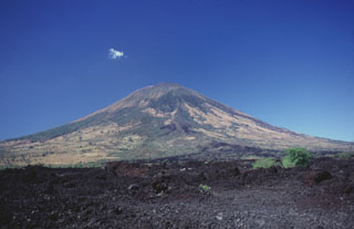
Volcán de San Miguel (Chaparrastique), in southern El Salvador, was active with several flank lava flows during the 17th-19th centuries, but recent activity has consisted of occasional ash eruptions from the summit crater. The beginning of the most recent eruption on 29 December 2013 resulted in a large ash plume that rose to 9.7 km altitude, and dispersed ash to many communities within 30 km of the volcano (BGVN 40:08). Intermittent ash plumes lasted through 28 July 2014. This report covers activity from January 2015 through June 2017, and describes six small ash emission events during this time. Information about San Miguel comes from the the Ministero de Medio Ambiente y Recursos Naturales (MARN) of El Salvador, and the Washington Volcanic Ash Advisory Center (VAAC).
Six ash-bearing explosions occurred at San Miguel between January 2015 and June 2017. Otherwise, minor seismicity and pulses of gas-and-steam emissions were the primary type of activity. The explosion on 26 January 2015 sent a plume 300 m above the crater, drifting SW. An explosion on 11 April 2015 resulted in an ash plume rising about 800 m above the crater that also drifted SW. Trace amounts of ash were emitted on 13 August 2015. The largest explosion of the period took place on 12 January 2016, when an ash plume drifting W caused ashfall as far as 25 km away, and the plume was ultimately visible as far as 300 km from the volcano. Incandescence was observed at the base of the 900-m-high eruptive column that appeared on 18 June 2016. Minor ash emissions were reported on 7 January 2017 drifting 130 km SW from San Miguel. Minor seismic swarms and steam-and-gas plumes were reported during February-June 2017.
Activity during 2015. After very little activity other than slightly elevated RSAM values since July 2014, a small ash-bearing explosion occurred on 26 January 2015 (figure 18). The ash plume rose about 300 m above the crater and drifted SW, dissipating quickly. Trace amounts of ash fell in the Piedra Azul area about 6 km SW of the crater.
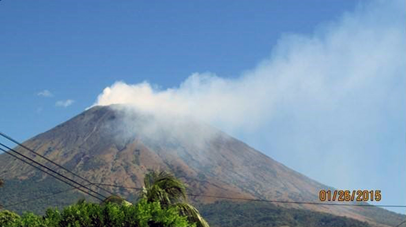 |
Figure 18. Gas-and-steam emissions at San Miguel on 26 January 2015, after an ash-bearing explosion that occurred earlier in the day. Courtesy of MARN (Informe Especial No. 8. Continúa constante emanación de gases del volcán Chaparrastique January 27, 2015 at 11:21 am). |
Another emission lasting for 20 minutes on 22 February 2015 sent a column of gas 300 m above the crater that dispersed to the SSW; no ash was observed. Occasional pulses of gas were reported during March rising 200 m above the summit crater. An explosion on 11 April 2015 resulted in an ash plume rising about 800 m above the crater and drifting SW. Local observers reported a millimeter of ashfall in the areas of La Piedra, Morita, and San Jorge, less than 10 km to the SW.
Occasional small pulses of gas that rose to about 200 m above the crater were typical behavior during May-July (figure 19). On 13 August 2015, the webcam captured a gas plume emission that contained minor amounts of ash and rose 200-300 m above the crater. A millimeter of ashfall was reported in San Jorge, and near the communities of Moritas and Piedrita to the SW. No emissions were reported during September, and the small pulses of gas observed during October did not exceed 200 m above the summit crater. No anomalous activity was reported during November, and small discrete pulses of gas were the only activity reported for December 2015.
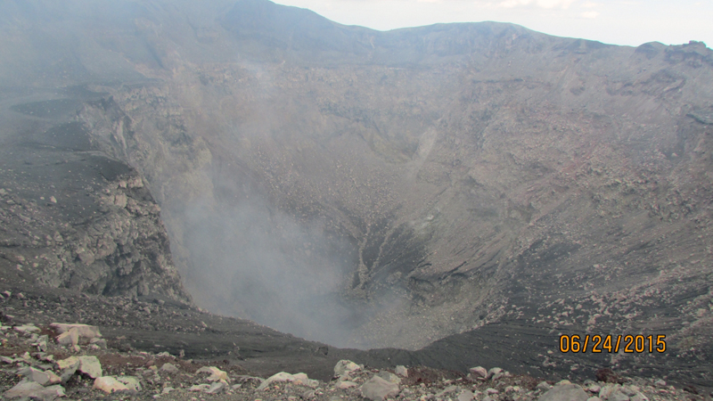 |
Figure 19. Diffuse degassing from the summit crater at San Miguel on 24 June 2015. Courtesy of MARN (Informe Mensual de Monitoreo Volcánico Junio, 2015). |
Activity during 2016. San Miguel began the year with what MARN described as a VEI 1 eruption of ash and gas on 12 January 2016 (figure 20). Periodic pulses of ash and gas lasting 3-5 minutes rose to less than 1,000 m above the crater and drifted WSW. Ashfall was reported from La Piedra, Moritas, La Placita, San Jorge, (all less than 10 km SW), San Rafael Oriente (10 km SW), Alegría (25 km NW) and Berlin in Usulután (21 km SW).
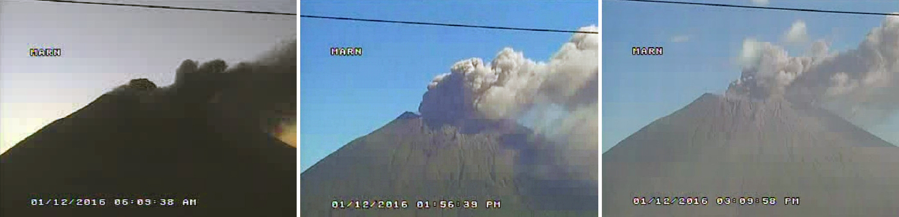 |
Figure 20. Ash eruption at San Miguel in the early morning of 12 January 2016. Image from the MARN webcam on the N side of the volcano. Courtesy of MARN (Informe Mensual de Monitoreo Volcánico Enero, 2016). |
NASA Earth Observatory captured images of two pulses of ash from the 12 January eruption that show the changing direction of the plume (figure 21). The first image, taken at 1635 (UTC) shows the ash plume headed directly W. The second image, taken three hours later at 1935 shows the active plume drifting SW, with the earlier plume segment farther to the W over the Pacific Ocean. The Washington VAAC reported the ash emission at 2.4 km altitude (300 m above the summit crater) drifting WSW at 1745 (UTC). At that time, the denser part of the plume extended 45 km from the volcano and the diffuse, wispy plume extended 130 km WSW. By midday on 13 January, the Washington VAAC reported ongoing emissions and that the plume extended 300 km SW. The plume was no longer visible in satellite images by the end of the day.
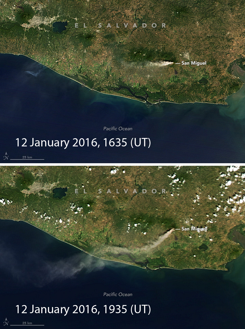 |
Figure 21. Moderate Resolution Imaging Spectroradiometer (MODIS) sensors on NASA's Aqua and Terra satellites acquired these natural-color images of ash streaming from San Miguel on 12 January 2016. Terra captured the upper image at 1035 local time (1635 UTC) which shows the ash plume drifting W; Aqua captured the lower image three hours later at 1335 local time (1935 UTC), and it shows the SW drift of the plume with the older remnant to the W over the Pacific Ocean. Courtesy of NASA Earth Observatory. |
Seismicity declined during 12-14 January 2016. On 15 January, local observers reported a millimeter of ash deposited in Las Cruces on the N flank. Gas emissions during 17-18 January were weak, only rising 150 m. At 0900 on 18 January, the emission plume became dark and drifted SW. By the next crater inspection on 19 February, MARN scientists noted only minor degassing from the summit crater.
Although a period of volcanic tremor occurred on 8 March 2016, only short pulses of gas were observed that did not rise more than 150 m above the crater. Another spike in seismicity occurred on 3 April, but no gas or ash emissions were observed. Otherwise, only minor pulses of gas issued from the crater during February through May. A seismic swarm indicating rock fracturing at depth on 31 May could have resulted in trace amounts of ash deposited within the crater, but cloudy weather prevented observations. A few pulses of gas were observed from the webcam other times during May.
Seismic activity increased significantly during the second week in June. An explosion in the early morning of 18 June 2016 lasted about 60 seconds, and sent an ash emission to about 900 m above the crater (figure 22). Incandescence was observed within the eruptive column, and the debris fell about 100 m down the N flank. Ashfall of less than half a millimeter was reported in the El Volcan area about 7 km NE of the crater. The volcanologist who examined the ash determined that it was juvenile material from a magmatic explosion. A continuous column of steam-and-gas issued from the crater until 29 June (figure 23). During this time, local observers and officials from the Civil Protection of San Jorge reported sulfur odors and slight acid rain damage to the vegetation in the La Morita, La Piedrita, La Ceiba, and LACAYO farms, located about 4 km W of the crater.
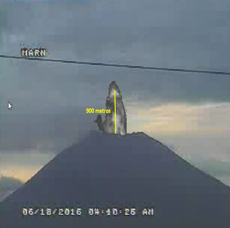 |
Figure 22. The pre-dawn eruption of 18 June 2016 at San Miguel photographed from the MARN webcam. The ash emission rose to about 900 m above the summit crater. Courtesy of MARN (Informe Mensual de Monitoreo Volcánico Junio, 2016). |
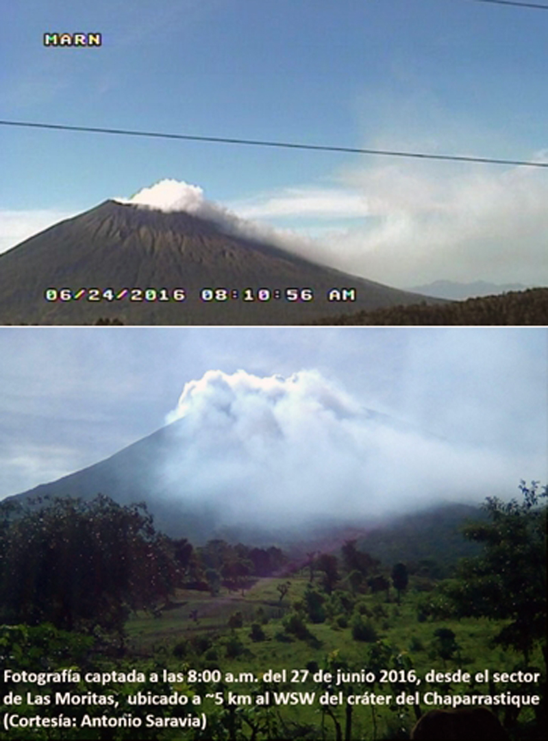 |
Figure 23. Gas plumes from San Miguel during the second half of June 2016 caused acid rain damage to vegetation W of the volcano. Upper image from the MARN webcam taken on 24 June 2016. The lower image was taken at 0800 on 27 June near Las Moritas, about 5 km WSW of the crater by Antonio Saravia. Courtesy of MARN (Informe Mensual de Monitoreo Volcánico Junio, 2016). |
Seismic activity was slightly elevated during the first half of July 2016, but otherwise only small pulses of gas were observed from the crater. Low-level activity continued from the summit crater during August. On 29 August, however, a seismic signal indicative of a lahar was noted near the VSM (Santa Isabel) seismic station, but no damage was reported. Periodic pulses of gases were noted during September 2016. A 20-minute-long seismic signal on 5 September indicated another lahar passing near seismic station VSM, but no damage was reported. GPS measurements during September indicated deformation of a few millimeters on the N flank. No explosions were reported during October-December 2016, only small plumes of steam and gas were observed (figure 24).
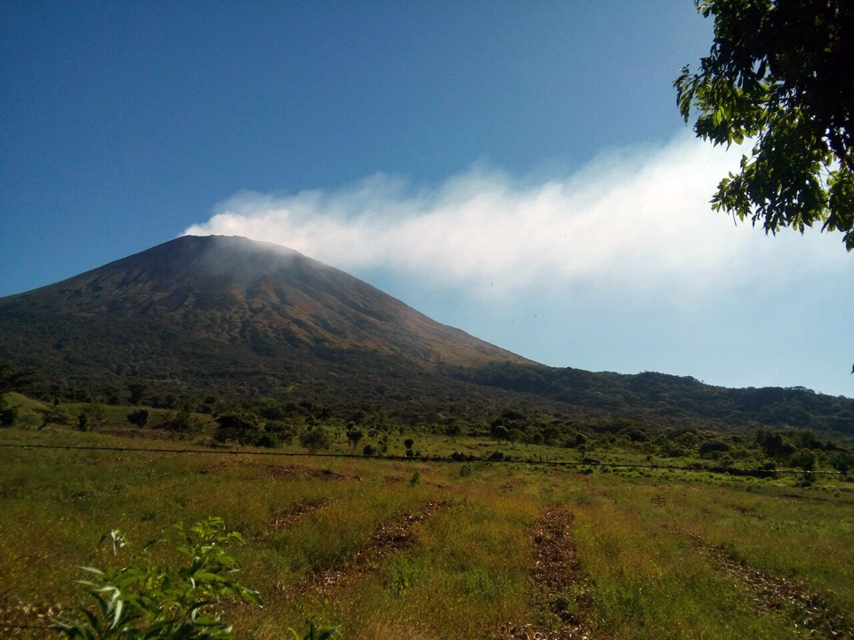 |
Figure 24. Steam-and-gas plumes blowing SW from San Miguel during December 2016. Image taken by the webcam located at the El Pacayal (Chinameca) volcano about 8 km S. Courtesy of MARN (Informe Mensual de Monitoreo Volcánico Diciembre, 2016). |
Activity during January-June 2017. On 7 January 2017, the Washington VAAC reported minor volcanic ash emissions from San Miguel at 2.6 km altitude extending SW about 130 km from the summit. Mild degassing continued during February and March. A brief seismic swarm occurred on 17 April 2017, but no explosions of gas or ash were observed in the webcam. A strong gas plume rose 1.2 km above the crater rim on 27 April. Seismicity decreased during May. Other than small gas plumes, the only activity reported during June 2017 was a slight increase in seismicity beginning on 12 June and lasting to the end of the month.
Geological Summary. The symmetrical cone of San Miguel, one of the most active volcanoes in El Salvador, rises from near sea level to form one of the country's most prominent landmarks. A broad, deep, crater complex that has been frequently modified by eruptions recorded since the early 16th century caps the truncated unvegetated summit, also known locally as Chaparrastique. Flanks eruptions of the basaltic-andesitic volcano have produced many lava flows, including several during the 17th-19th centuries that extended to the N, NE, and SE. The SE-flank flows are the largest and form broad, sparsely vegetated lava fields crossed by highways and a railroad skirting the base of the volcano. Flank vent locations have migrated higher on the edifice during historical time, and the most recent activity has consisted of minor ash eruptions from the summit crater.
Information Contacts: Ministero de Medio Ambiente y Recursos Naturales (MARN), Km. 5½ Carretera a Nueva San Salvador, Avenida las Mercedes, San Salvador, El Salvador (URL: http://www.snet.gob.sv/ver/vulcanologia); Washington Volcanic Ash Advisory Center (VAAC), Satellite Analysis Branch (SAB), NOAA/NESDIS OSPO, NOAA Science Center Room 401, 5200 Auth Rd, Camp Springs, MD 20746, USA (URL: http://www.ospo.noaa.gov/Products/atmosphere/vaac/, archive at: http://www.ssd.noaa.gov/VAAC/archive.html).