Report on Reventador (Ecuador) — July 2017

Bulletin of the Global Volcanism Network, vol. 42, no. 7 (July 2017)
Managing Editor: Edward Venzke.
Edited by A. Elizabeth Crafford.
Reventador (Ecuador) Lava flow emerges from summit cone, January 2016; continued explosions, pyroclastic flows, and ash emissions
Please cite this report as:
Global Volcanism Program, 2017. Report on Reventador (Ecuador) (Crafford, A.E., and Venzke, E., eds.). Bulletin of the Global Volcanism Network, 42:7. Smithsonian Institution. https://doi.org/10.5479/si.GVP.BGVN201707-352010
Reventador
Ecuador
0.077°S, 77.656°W; summit elev. 3562 m
All times are local (unless otherwise noted)
The andesitic Volcán El Reventador lies well east of the main volcanic axis of the Cordillera Real in Ecuador and has historical observations of eruptions with numerous lava flows and explosive events going back to the 16th century. The largest historical eruption took place in November 2002 and generated a 17-km-high eruption cloud, pyroclastic flows that traveled 8 km, and several lava flows. From June 2014-December 2015, monthly eruptive activity included ash plumes, lava flows, pyroclastic flows, and ejected incandescent blocks (BGVN 42:06). Similar activity during January-April 2016 is described below with information provided by the Instituto Geofisico-Escuela Politecnicia Nacional (IG) of Ecuador, and the Washington Volcanic Ash Advisory Center (VAAC).
Almost daily eruptive activity continued during January-April 2016. Steam and gas emissions, usually containing minor amounts of ash, were visible at the summit crater on most clear days rising 500-1,000 m above the 3.6-km-high summit. Explosions sent incandescent blocks 500-1,500 m down all flanks several times each month. Pyroclastic flows also traveled similar distances down the flanks a few times each month. A lava flow was observed descending the N flank of the summit cone on 28 January 2016.
Steam and gas emissions, usually with minor amounts of ash, rose daily from the summit crater during January 2016. Plumes generally rose 500-1,000 m and drifted NW or W. A pyroclastic flow descended 1,000 m down the NE flank on 5 January. Loud explosions were heard in the community of El Reventador (15 km E) on 6 and 7 January, and plumes were observed 1.5 km above the crater. The Washington VAAC reported an ash emission moving SW on 9 January at 4.6 km altitude; it extended 65 km SW before dissipating. The Guayaquil Meteorological Weather Office (MWO) reported an ash emission on 12 January at 6.7 km altitude, but extensive cloud cover prevented satellite observation.
The Washington VAAC observed emissions in satellite imagery moving 25 km NW on 15 and 16 January at about 4.9 km altitude. Technical crews performing maintenance on 15 January observed and documented several explosions with ash plumes that reached 2 km above the summit (about 5.5 km altitude) and observed a pyroclastic flow that moved 500 m down the N flank (figure 53). They also noted pyroclastic deposits that had been emplaced during recent weeks along the N flank. Small pyroclastic flows during the night of 18 January descended the flanks of the cone for 1,000 m. Additional explosions the next day sent blocks down the SW flank. On 21 January, incandescent blocks traveled 1,200 m down the W flank; on 27 January, they were observed 500 m below the summit crater. The Washington VAAC observed a hotpot in infrared imagery on 24 January.
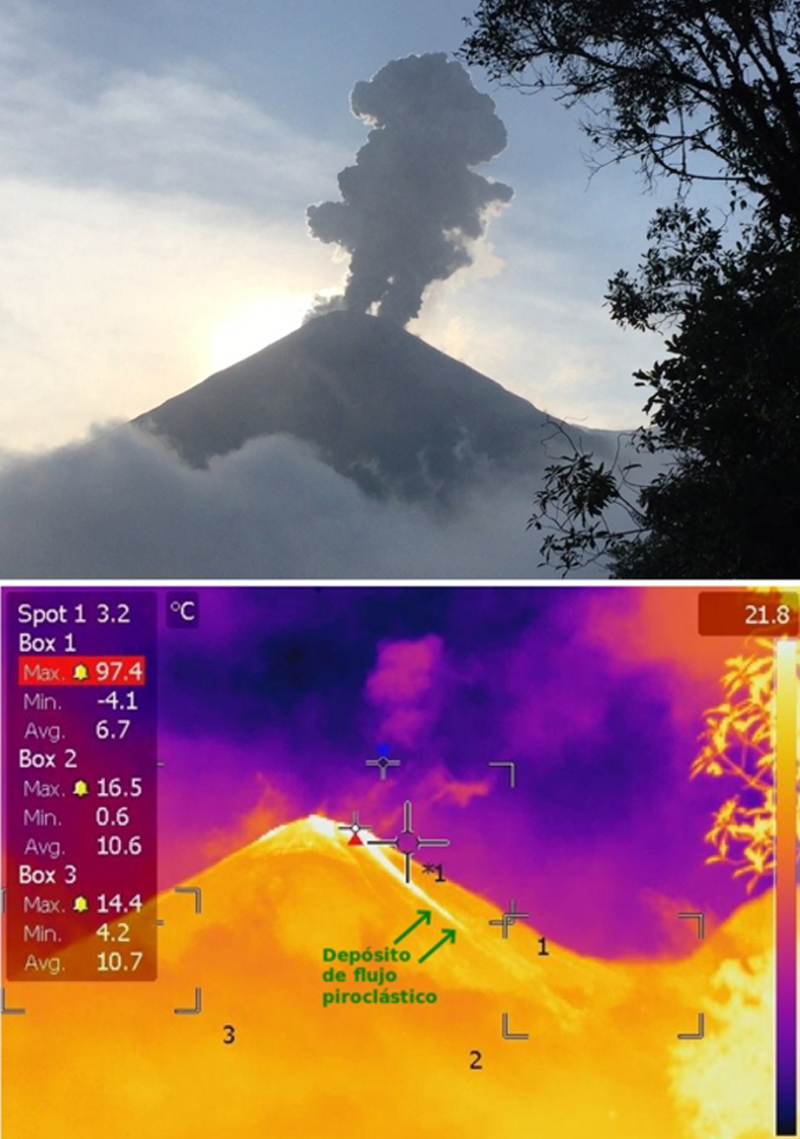 |
Figure 53. Activity at Reventador on 15 January 2016 was documented by technicians working on monitoring equipment. Top: an ash column reached 1.5 to 2 km above the summit during the afternoon. Bottom: A pyroclastic flow traveled 500 m down the flank as seen in this thermal image. Top photo by J. Córdoba, courtesy of IG-EPN (Actualization de la Actividad eruptive del volcán Reventador Informe 2016-1). |
On 28 January 2016, IG conducted an overflight and observed pulsing fumarolic activity producing plumes with low to moderate ash emissions drifting W. They noted pyroclastic flow deposits on all the flanks that did not go beyond the foot of the active cone. They also witnessed an active lava flow descending the N flank, emerging from a vent on the N side of the summit of the cone (figure 54). Thermal measurements were taken at the N vent (501°C ), the central vent (372.8°C), and the base of the flow (324.6°C) (figure 55). MODVOLC thermal alerts were reported on eight days during January (6, 9 (4), 14, 16 (3), 18 (3), 25 (2), 27 (3), 29, 31).
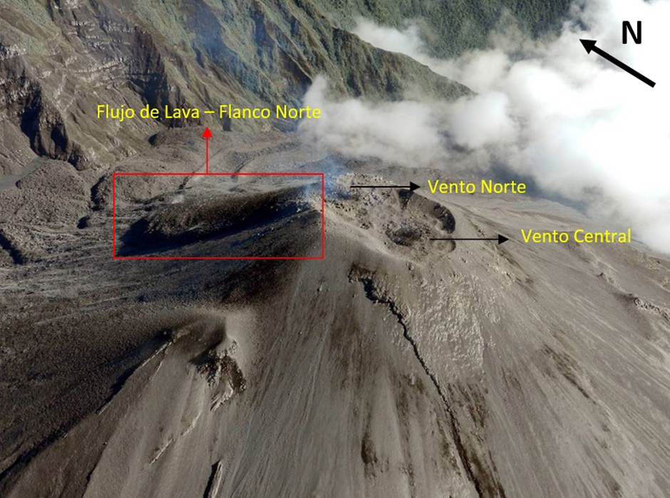 |
Figure 54. A lava flow descends the N flank of the summit cone at Reventador on 28 January 2016 as seen during an overflight by IG. The lava is emerging from a vent on the N side of the summit 'Vento Norte,' distinct from the vent at the center of the summit 'Vento Central.' Photo by M Almeida, courtesy of IG-EPN (Resumen de las Observaciones efectuadas durante el vuelo efectuado el 28 de enero de 2016). |
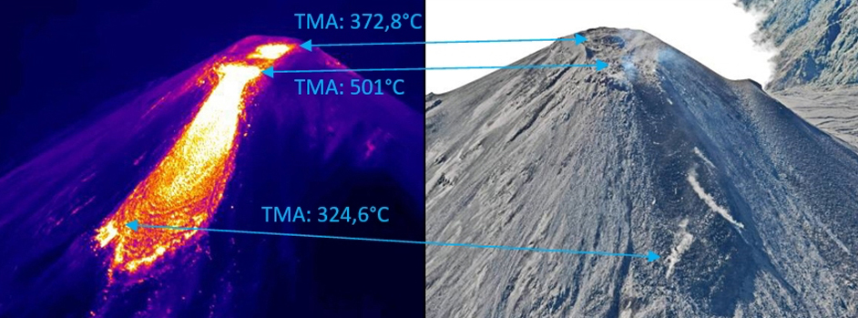 |
Figure 55. Closeup view of the 28 January 2016 lava flow at Reventador showing the temperature values from three different locations. The temperature at the central vent was 372.8°C, at the N vent from which the flow emerged it was 501°C, and 324.6°C at the base of the flow. The points of thermal measurement are shown in the corresponding photograph on the right. Minor gas emissions drifted W. Thermal image by P. Ramón, photograph by M. Almeida, courtesy of IG-EPN (Resumen de las Observaciones efectuadas durante el vuelo efectuado el 28 de enero de 2016). |
Reventador was quieter during February 2016 than in January. Steam and gas emissions with minor ash were observed often, with emissions generally below 500 m above the crater. Incandescent blocks observed on 4 February were 1,000 m below the summit crater. The Washington VAAC reported ash emissions visible in satellite imagery on 5 February moving SSW, extending about 25 km at 4.3 km altitude (about 700 m above the summit crater); they also observed incandescence at the crater. Incandescence was again observed on 6 and 7 February; blocks traveled 700 m down the SW flank on 13 February. A diffuse, narrow plume of ash was drifting NW from the summit on 14 February at 4.6 km altitude. The Guayaquil MWO reported an ash plume at 6.1 km altitude moving W on 23 February, but weather clouds obscured views in satellite imagery. Although it was cloudy on 27 February, loud explosions were heard during the night. MODVOLC thermal alerts were reported on seven days of the month; 1 (3), 3 (5), 5 (4), 6, 14 (3), 19, and 26 (3).
Tourists visiting the Hostería el Reventador observed steam, gas, and ash emissions on 2 March 2016. On many clear days during March, emissions of steam with minor ash were observed rising 1 km above the summit crater, drifting NW, W or SW. Incandescence and pyroclastic flows were seen much more frequently than during February. A pyroclastic flow traveled down the SE flank on 5 March. Explosions that afternoon sent incandescent blocks 1,200 m down the E and SE flanks. This activity continued through 9 March with blocks traveling daily 500-1,000 m down the flanks. On 9 March, ash emissions rose to 1 km above the crater and drifted NW; morning explosions sent blocks 1,200 m down the flanks and a small pyroclastic flow was observed that night. Explosions with steam and ash rising 1 km above the summit were observed on 10 March. Incandescence at the summit, and blocks rolling up to 1,500 m down the flanks were observed on most clear nights during the second half of March. A pyroclastic flow on 20 March descended 2 km down the SW flank. Steam and ash were reported drifting W 1 km above the crater on 21 March.
The Guayaquil MWO reported ash emissions on 7 March to 4.9 km, but weather clouds prevented observations by the Washington VAAC. On 10 March, ash emissions were confirmed in satellite imagery at 6.1 km altitude drifting W. The MWO reported ash emissions at 6.4 km altitude on 15 March, but weather clouds again prevented satellite observation. Webcam images showed ash emissions on 18 March at 4.3 km altitude drifting NW. The next day, the Washington VAAC was able to observe emissions in both satellite imagery and the webcam drifting W at 5.5 km altitude. Possible emissions on 31 March were also obscured by weather clouds. MODVOLC thermal alerts were reported on 7 days during March; 6, 15 (2), 16 (2), 22 (4), 26 (4), 29, 31.
Explosions that sent incandescent blocks down the flanks were observed nine times during April 2016, on days 3, 4, 7, 9, 12, 19, 23, 25, and 26. They generally travelled 1,000 m or more down various flanks. They were observed 2,000 m down the SW flank after a large explosion on 23 April. Pyroclastic flows were observed three times. On 6 April they traveled 1,500 m down the NW flank; on 13 and 21 April they traveled 1,000 m down the E flank. Steam and gas emissions were observed on most clear days, and generally contained minor amounts of ash. The plumes usually rose 300 to 800 m above the summit and drifted W, but on 13 and 18 April they rose 2 km above the summit, according to INSIVUMEH.
The Washington VAAC reported a possible ash emission on 4 April drifting NW at 4.3 km altitude based on a brief emission witnessed from the webcam. Weather clouds prevented satellite imagery views. There were also reports of volcanic ash at 6.7 km altitude drifting SE on 12 April, but both the webcam and satellite imagery were obscured by clouds. Observers reported an ash plume moving NE at 5.5 km altitude the next day. Ash emissions were reported moving NW at 5.8 km altitude on 29 April, but weather clouds again obscured satellite imagery. MODVOLC thermal alerts were reported on 8 days of April: 3, 11 (2), 14 (2), 19 (2), 20, 25 (4), 26 (3), 30.
Geological Summary. Volcán El Reventador is the most frequently active of a chain of Ecuadorian volcanoes in the Cordillera Real, well east of the principal volcanic axis. The forested, dominantly andesitic stratovolcano has 4-km-wide avalanche scarp open to the E formed by edifice collapse. A young, unvegetated, cone rises from the amphitheater floor to a height comparable to the rim. It has been the source of numerous lava flows as well as explosive eruptions visible from Quito, about 90 km ESE. Frequent lahars in this region of heavy rainfall have left extensive deposits on the scarp slope. The largest recorded eruption took place in 2002, producing a 17-km-high eruption column, pyroclastic flows that traveled up to 8 km, and lava flows from summit and flank vents.
Information Contacts: Instituto Geofísico (IG), Escuela Politécnica Nacional, Casilla 17-01-2759, Quito, Ecuador (URL: http://www.igepn.edu.ec/); Washington Volcanic Ash Advisory Center (VAAC), Satellite Analysis Branch (SAB), NOAA/NESDIS OSPO, NOAA Science Center Room 401, 5200 Auth Rd, Camp Springs, MD 20746, USA (URL: http://www.ospo.noaa.gov/Products/atmosphere/vaac/, archive at: http://www.ssd.noaa.gov/VAAC/archive.html); Hawai'i Institute of Geophysics and Planetology (HIGP) - MODVOLC Thermal Alerts System, School of Ocean and Earth Science and Technology (SOEST), Univ. of Hawai'i, 2525 Correa Road, Honolulu, HI 96822, USA (URL: http://modis.higp.hawaii.edu/).