Report on Sangay (Ecuador) — August 2017

Bulletin of the Global Volcanism Network, vol. 42, no. 8 (August 2017)
Managing Editor: Edward Venzke.
Edited by A. Elizabeth Crafford.
Sangay (Ecuador) Intermittent ash emissions and thermal anomalies, January 2015-July 2017
Please cite this report as:
Global Volcanism Program, 2017. Report on Sangay (Ecuador) (Crafford, A.E., and Venzke, E., eds.). Bulletin of the Global Volcanism Network, 42:8. Smithsonian Institution. https://doi.org/10.5479/si.GVP.BGVN201708-352090
Sangay
Ecuador
2.005°S, 78.341°W; summit elev. 5286 m
All times are local (unless otherwise noted)
Ecuador's Sangay, isolated on the east side of the Andean crest, has exhibited frequent eruptive activity over the last 400 years. Its remoteness has made ground observations difficult until recent times, and thus most information has come from aviation reports from the Washington Volcanic Ash Advisory Center (VAAC) and MODIS (Moderate Resolution Imaging Spectroradiometer) satellite-based data. Thermal anomaly information is reported by the University of Hawaii's MODVOLC system and the Italian MIROVA Volcano HotSpot Detection System. Ecuador's Instituto Geofísico (IG) issues periodic Special Reports of activity. This report summarizes the intermittent nature of the eruptions from 2011-2013, and covers renewed activity during January 2015 through July 2017.
Summary of activity during 2011-2013. Activity during 2011 (figure 17) began with a continuation of the intermittent ash emissions and thermal anomalies that persisted throughout 2010 (BGVN 36:01). Ash plumes during January and February 2011 were reported at typical altitudes between 6 and 8 km; thermal alerts appeared once each during January and March. No activity was reported after 2 March until a new series of thermal alerts began more than 3 months later on 6 June 2011; they were intermittent from then through 19 September 2012, with reports occurring during 1-4 days of all but three months. Ash emissions were also intermittent during this time, with VAAC reports issued during eight of the months from 2 August 2011-28 July 2012 for plumes reported at altitudes of 6-8 km. They also generally occurred during 1-4 days of the month. A four-month break in activity followed until ash plumes were reported on 25 January 2013; they were intermittent until 24 May 2013. MODVOLC thermal anomalies were also reported during this time, on 2 February, 25 March, and 3-4 May.
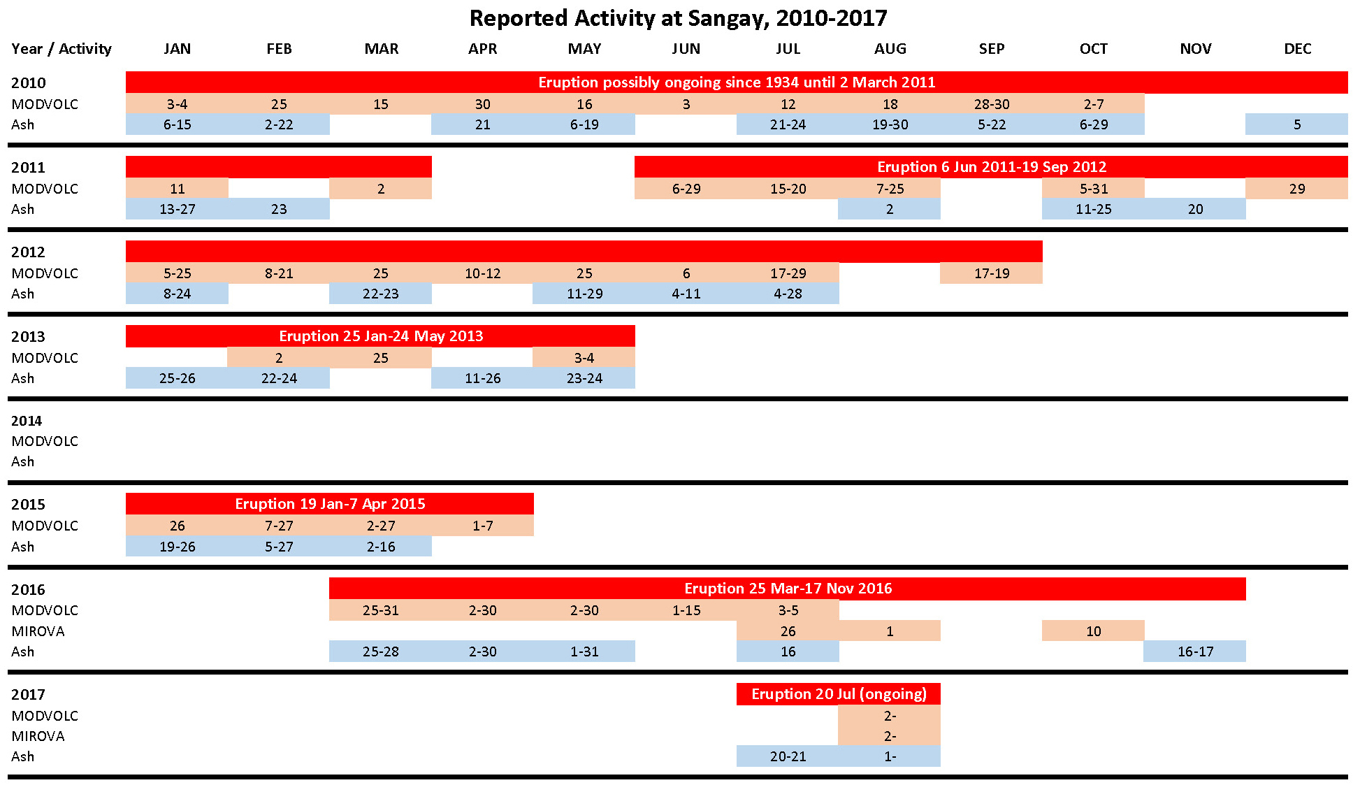 |
Figure 17. Summary chart of ash emissions and thermal anomalies reported from Sangay during January 2010 to early August 2017. Red bars show eruptive periods where there are reports of either ash plumes or thermal anomalies without a lack of observed activity for more than 3 months. Rows with pink cells indicate dates with thermal anomalies (MODVOLC or MIROVA). Rows with blue cells indicate dates with ash emissions as reported by the Washington VAAC. A range of dates means that activity occurred at least on those two dates, but may not have been continuous. Data courtesy of Washington VAAC, HIGP MODVOLC Thermal Alerts System, and MIROVA. |
Summary of activity during January 2015-July 2017. After 19 months of quiet from June 2013 through December 2014, an ash plume reported on 19 January 2015 marked the beginning of a new eruptive episode that included ash plumes, lava flows, and block avalanches between 19 January and 7 April 2015. The next reported activity included both ash emissions and thermal anomalies observed almost a year later on 25 March 2016, although IG had reported increases in seismicity during the previous two weeks. Ash emissions and thermal anomalies were intermittent through 16 July 2016. There was a single thermal anomaly seen in MIROVA data on about 10 October and a brief ash emission occurred during 16-17 November 2016, after which Sangay was quiet until a new episode started on 20 July 2017 that was ongoing into August.
Activity during January-April 2015. After a 19-month period of no reported activity (since May 2013), ash emissions were again seen beginning on 18 January 2015 when an ash plume rose to 6.4 km altitude and drifted SW. Additional plumes on 25 January and 4 February rose to 7.3 km and 6.7 km, respectively, and drifted less than 20 km SW (figure 18). Ash plumes primarily observed by pilots between 27 February and 16 March were generally not visible in satellite images due to weather clouds. During this episode, MODVOLC thermal alerts were reported on 26 January; 7, 21, 23 and 27 February; 2,4,18, and 27 March; and 1, 3, and 7 April.
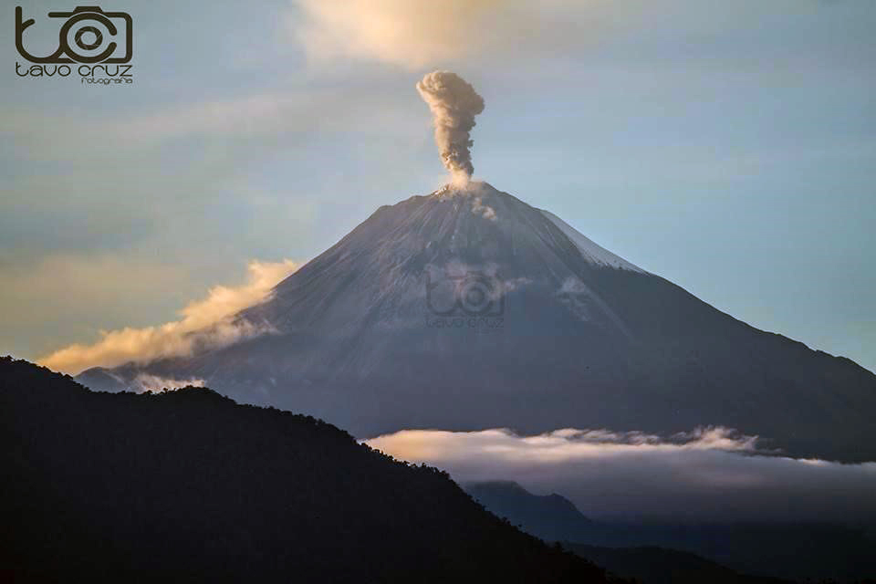 |
Figure 18. Ash emission at Sangay sometime during 19-26 January 2015. The ash plume eventually reached about 2 km above the 5,286-m-high summit crater. Photo by Gustavo Cruz, courtesy of IG (Informe Especial del Volcan Sangay No 1, 16 March 2015). |
In a March 2015 report, IG noted that new lava flows and block-avalanche deposits had been emplaced during January and February 2015. The lava flows descended the SE flank about 900 m (figure 19). Two areas of deposits from block avalanches and ashfall extended 2.5 km ESE from the lava front, and 1.5 km down the S flank. According to IG, there were 21 thermal anomalies identified in MIROVA during 31 January-25 February 2015.
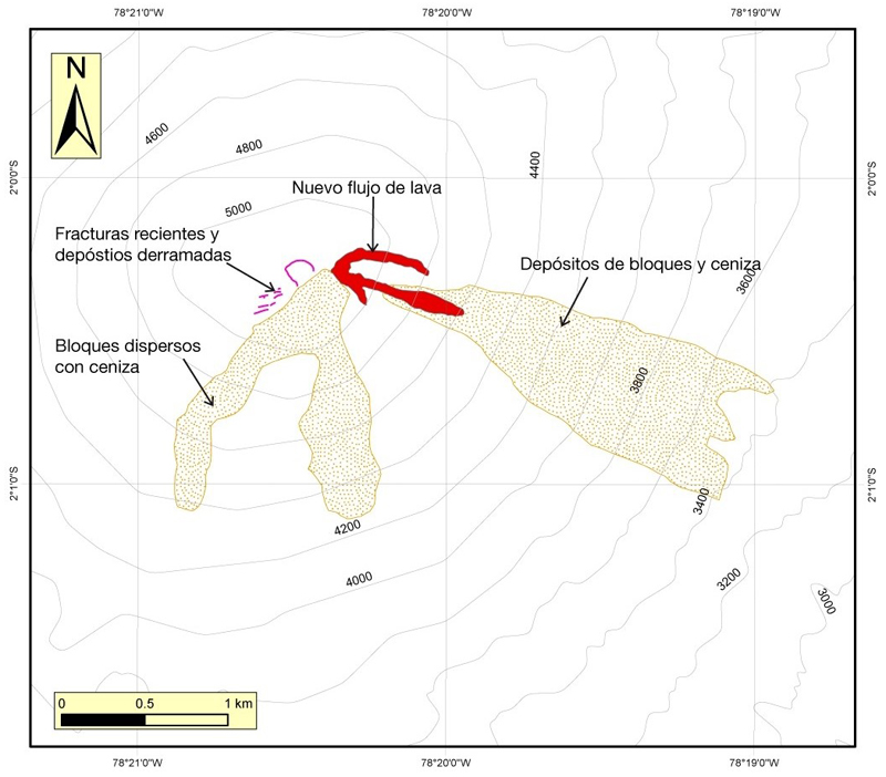 |
Figure 19. Locations of lava flows and block-avalanche deposits at Sangay that were emplaced during January and February 2015. The new lava flows are shown in red. The ash and block-avalanche deposits are shown in stippled yellow/green. Courtesy of IG (Informe Especial del Volcan Sangay No 1, 16 March 2015). |
Activity during March-November 2016. IG reported an increase in seismicity on 5 March 2016, after ten months of no reported activity. An explosion signal was followed by harmonic tremor on 9 March, and IG noted that both a thermal anomaly and an emission drifting S were identified in NOAA satellite images. They inferred that increased seismic "explosion" signals on 14 March were indicative of ash-and-gas emissions, although weather clouds prohibited visual confirmation. Ash emissions rising to 6.1 km altitude were first reported by the Guayaquil MWO on 25 March 2016; they noted two more emissions on 27 and 28 March rising to similar altitudes (7.6 and 6.4 km, respectively), but cloudy weather prevented satellite confirmation. Plumes reported on nine days during April rose to similar altitudes (ranging from 5.5-7 km) and extended 18-30 km N or NW from the summit. A series of daily emissions occurred from 30 April-7 May. The emissions included a plume on 2 May that extended 120 km NW, and one on 6 May that rose to 8.2 km altitude and extended approximately 55 km SW before dissipating. Ash-bearing plumes were reported on 10 more days during the rest of May.
Although no more ash plumes were reported until 16 July 2016, MODVOLC thermal alerts were persistent every month beginning on 25 March and lasting through 5 July (see figure 17 above). The MIROVA data for this period also clearly show persistent thermal anomalies (figure 20). A short-lived eruption event during 16-17 November 2016 consisted of an ash emission that rose to 6.1 km altitude and drifted as far as 290 km SE.
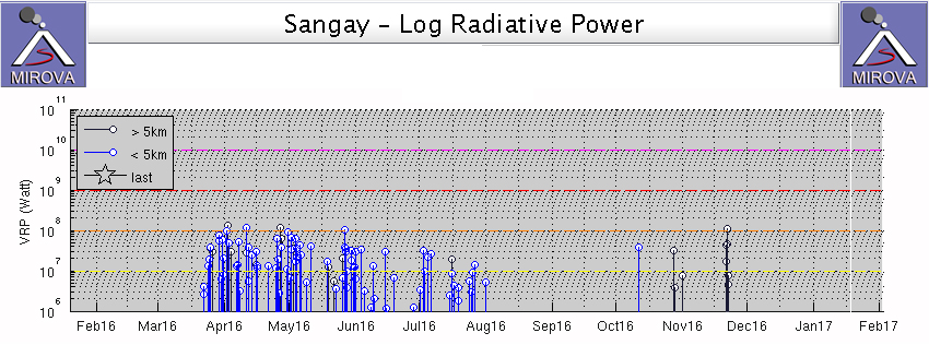 |
Figure 20. Thermal anomaly data from MIROVA for the year ending on 18 January 2017 at Sangay, showing the eruptive episode of March-July 2016, and a brief anomaly on about 10 October 2016; late October-November anomalies are more than 20 kilometers from the summit and unrelated to volcanism. Courtesy of MIROVA. |
Activity beginning July 2017. A new eruptive episode began on 20 July 2017, after eight months without major surface activity. Low-energy ash emissions rising to 3 km above the crater, incandescent block avalanches on the ESE flank (figure 21), and a possible new lava flow were reported by IG. The Washington VAAC reported an ash emission on 20 July rising to 8.2 km altitude and drifting about 80 km W. A plume was reported on 1 August by the Guyaquil MWO but obscured by clouds in satellite images, and a plume on 2 August was seen in webcam images (figure 22).
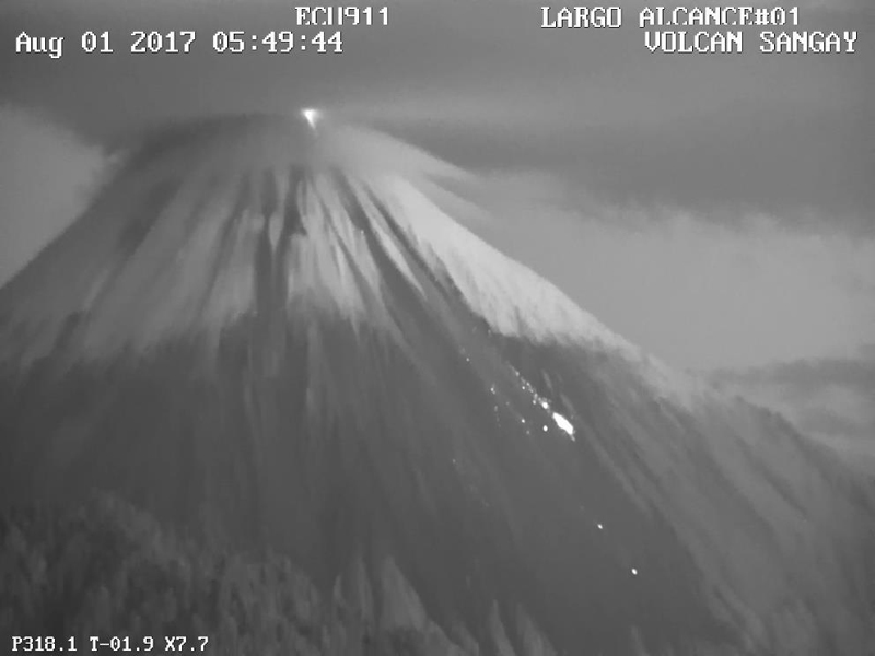 |
Figure 21. Incandescent blocks roll down the ESE flank of Sangay during the early morning of 1 August 2017. Courtesy of IG (Informe Especial del Volcán Sangay-2017-No 1, 3 August 2017). |
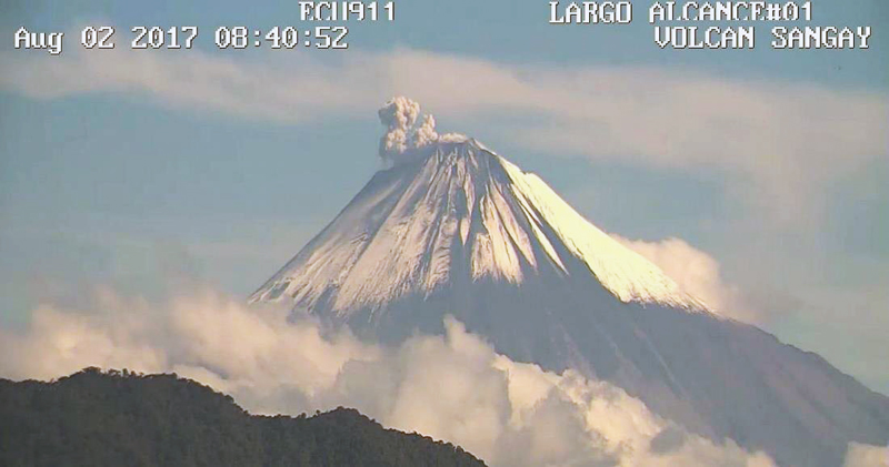 |
Figure 22. Ash emission at Sangay on 2 August 2017, with the plume rising about 400 m above the summit crater drifting SW. Courtesy of IG (Informe Especial del Volcán Sangay-2017-No 1, 3 August 2017). |
Geological Summary. The isolated Sangay volcano, located east of the Andean crest, is the southernmost of Ecuador's volcanoes and its most active. The steep-sided, glacier-covered, dominantly andesitic volcano grew within the open calderas of two previous edifices which were destroyed by collapse to the east, producing large debris avalanches that reached the Amazonian lowlands. The modern edifice dates back to at least 14,000 years ago. It towers above the tropical jungle on the east side; on the other sides flat plains of ash have been eroded by heavy rains into steep-walled canyons up to 600 m deep. The earliest report of an eruption was in 1628. Almost continuous eruptions were reported from 1728 until 1916, and again from 1934 to the present. The almost constant activity has caused frequent changes to the morphology of the summit crater complex.
Information Contacts: Instituto Geofísico (IG), Escuela Politécnica Nacional, Casilla 17-01-2759, Quito, Ecuador (URL: http://www.igepn.edu.ec/); Washington Volcanic Ash Advisory Center (VAAC), Satellite Analysis Branch (SAB), NOAA/NESDIS OSPO, NOAA Science Center Room 401, 5200 Auth Rd, Camp Springs, MD 20746, USA (URL: http://www.ospo.noaa.gov/Products/atmosphere/vaac/, archive at: http://www.ssd.noaa.gov/VAAC/archive.html); Hawai'i Institute of Geophysics and Planetology (HIGP), MODVOLC Thermal Alerts System, School of Ocean and Earth Science and Technology (SOEST), Univ. of Hawai'i, 2525 Correa Road, Honolulu, HI 96822, USA (URL: http://modis.higp.hawaii.edu/); MIROVA (Middle InfraRed Observation of Volcanic Activity), a collaborative project between the Universities of Turin and Florence (Italy) supported by the Centre for Volcanic Risk of the Italian Civil Protection Department (URL: http://www.mirovaweb.it/).