Report on Langila (Papua New Guinea) — September 2017

Bulletin of the Global Volcanism Network, vol. 42, no. 9 (September 2017)
Managing Editor: Edward Venzke.
Research and preparation by Robert Andrews.
Langila (Papua New Guinea) Eruption continues, intensifying from mid-December 2016 through July 2017
Please cite this report as:
Global Volcanism Program, 2017. Report on Langila (Papua New Guinea) (Venzke, E., ed.). Bulletin of the Global Volcanism Network, 42:9. Smithsonian Institution. https://doi.org/10.5479/si.GVP.BGVN201709-252010
Langila
Papua New Guinea
5.525°S, 148.42°E; summit elev. 1330 m
All times are local (unless otherwise noted)
Eruptive activity at Langila was intermittent during 2016, with ash plumes seen during April-May and November-December (BGVN 42:01); thermal anomalies were somewhat more commonly detected, but were also intermittent. No reports were available from the Rabaul Volcano Observatory during January-July 2017, but volcanic ash warnings were issued by the Darwin Volcanic Ash Advisory Centre (VAAC). Thermal anomaly data acquired by satellite-based MODIS instruments showed a strong increase in activity beginning in mid-December 2016 that was ongoing as of early August 2017.
Ash plumes were reported frequently during the first half of 2017 except during March and early April. The plumes rose to altitudes between 1.8 and 3 km (table 4). The aviation color code has remained at Orange (third highest of a four-step universal volcanic ash alert level system for aviation) throughout 2016 and through July 2017.
Table 4. Ash plumes from Langila reported during January-June 2017. Observations are based on analyses of satellite imagery and wind data; dates are based on local time. Courtesy of the Darwin VAAC.
| Date | Max. Plume Altitude (km) | Drift |
| 02 Jan 2017 | 2.1 | NE |
| 05 Jan 2017 | 2.4 | 45 km W |
| 12-13, 15 Jan 2017 | 2.1 | ESE and SE |
| 25-27 Jan 2017 | 1.8-3 | NW and N |
| 17-18 Feb 2017 | 1.8 | SE |
| 24 Feb 2017 | 2.4 | N |
| 23-25 Apr 2017 | 2.1 | 55 km S and SE |
| 26 Apr 2017 | 2.1 | E and NE |
| 02 May 2017 | 2.1 | E and NE |
| 10-14 May 2017 | 1.8-2.4 | N, NW, and S |
| 19 May 2017 | 4.6 | ~170 km WSW |
| 19-20 May 2017 | 1.8 | N and NNW |
| 23 May 2017 | 2.1, 3 | NW, SW |
| 24-27 May 2017 | 2.1-3 | 75-85 km W and NW |
| 01 Jun 2017 | 1.8 | N and NW |
| 07 Jun 2017 | 2.1 | 45 km NW |
| 12 Jun 2017 | 1.8 | WNW |
| 20 Jun 2017 | 2.1 | NW |
| 21 Jun 2017 | 2.1 | 95 km NW |
Thermal alerts, based on MODIS satellite instruments analyzed using the MODVOLC algorithm, were identified often during December 2016 through June 2017. The MIROVA volcano hotspot detection system, also based on analysis of MODIS data, detected occasional anomalies from August 2016 through late December 2016 (BGVN 42:01), followed by more continuous anomalies through late July 2017 (figure 6). The most intense anomalies over this time period occurred from mid-April to early May 2017.
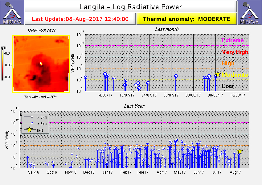 |
Figure 6. Plot of MIROVA thermal anomaly MODIS data for the year ending on 8 August 2017. Courtesy of MIROVA. |
Geological Summary. Langila, one of the most active volcanoes of New Britain, consists of a group of four small overlapping composite basaltic-andesitic cones on the lower E flank of the extinct Talawe volcano in the Cape Gloucester area of NW New Britain. A rectangular, 2.5-km-long crater is breached widely to the SE; Langila was constructed NE of the breached crater of Talawe. An extensive lava field reaches the coast on the N and NE sides of Langila. Frequent mild-to-moderate explosive eruptions, sometimes accompanied by lava flows, have been recorded since the 19th century from three active craters at the summit. The youngest and smallest crater (no. 3 crater) was formed in 1960 and has a diameter of 150 m.
Information Contacts: Darwin Volcanic Ash Advisory Centre (VAAC), Bureau of Meteorology, Northern Territory Regional Office, PO Box 40050, Casuarina, NT 0811, Australia (URL: http://www.bom.gov.au/info/vaac/); Hawai'i Institute of Geophysics and Planetology (HIGP) - MODVOLC Thermal Alerts System, School of Ocean and Earth Science and Technology (SOEST), Univ. of Hawai'i, 2525 Correa Road, Honolulu, HI 96822, USA (URL: http://modis.higp.hawaii.edu/); MIROVA (Middle InfraRed Observation of Volcanic Activity), a collaborative project between the Universities of Turin and Florence (Italy) supported by the Centre for Volcanic Risk of the Italian Civil Protection Department (URL: http://www.mirovaweb.it/).