Report on Masaya (Nicaragua) — September 2017

Bulletin of the Global Volcanism Network, vol. 42, no. 9 (September 2017)
Managing Editor: Edward Venzke.
Research and preparation by Robert Andrews.
Masaya (Nicaragua) Persistent lava lake and gas plume activity, with intermittent ash emission, through mid-July 2017
Please cite this report as:
Global Volcanism Program, 2017. Report on Masaya (Nicaragua) (Venzke, E., ed.). Bulletin of the Global Volcanism Network, 42:9. Smithsonian Institution. https://doi.org/10.5479/si.GVP.BGVN201709-344100
Masaya
Nicaragua
11.9844°N, 86.1688°W; summit elev. 594 m
All times are local (unless otherwise noted)
Masaya volcano near the Pacific Ocean in Nicaragua (figure 52) is one of the most active volcanos in that country. The period from October 2015 through August 2016 saw the re-emergence of the lava lake, increased seismic frequency and amplitude, intermittent explosive activity, and continued strong thermal anomalies from satellite and ground based sources as a result of the newly active lava lake. (BGVN 41:08). Thermal satellite data analyzed by MIROVA measured moderate volcanic radiative power beginning January 2016 and continuing regularly through August 2016. The Instituto Nicareguense de Estudios Territoriales (INETER), Sistema Nacional para la Prevencion, Mitigacion y Atencion de Desastres (SINAPRED), and the Washington Volcanic Ash Advisory Center (VAAC) monitor the volcano's activity and provide regular reports.
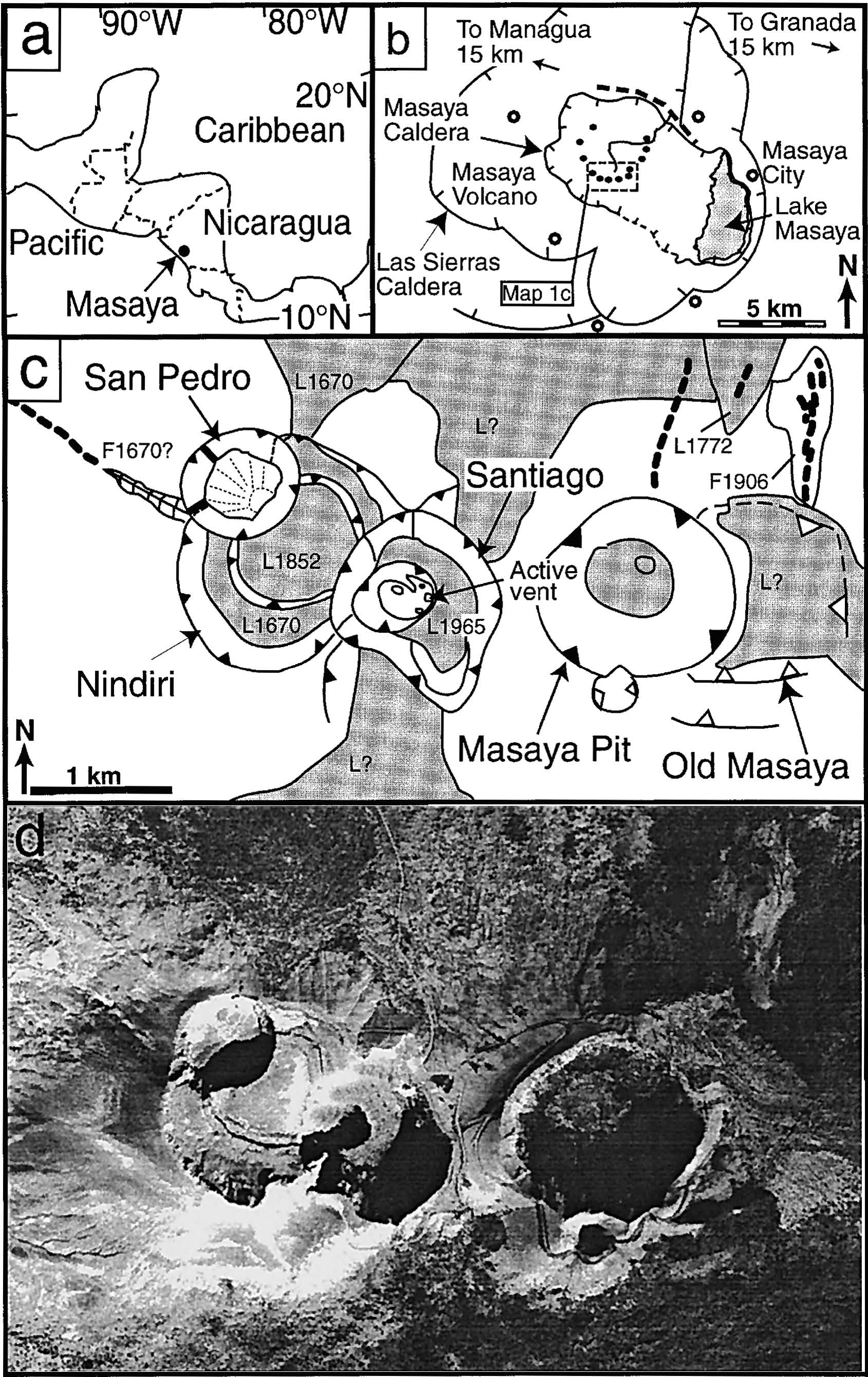 |
Figure 52. Maps and aerial photo of the Masaya complex. (a) Regional location map showing of Masaya. (b) Map showing the Las Sierras Caldera enclosing the Masaya caldera, which in turn encloses the recent vents (black dots); distances to major towns (circles) and cities are given. (c) Map of active crater area showing structural features, such as eruptive fissures (dashed lines), pit crater edges (filled triangles),and explosion crater edges (open triangles); lava flows and lakes (shaded) and tephra cover (blank) are also shown including dates of eruption (e.g. L1772 is the 1772 flow and F1906 is the fissure that erupted gas in 1906). (d) Aerial photo of the same area as the map in (c). From Rymer and others (1998). |
Ash and steam emissions have been reported by the Washington VAAC from satellite data from August 2016 through mid-July 2017, the latest on 13 May 2017 when both satellite images showed and a pilot observed a W-drifting ash emission from Masaya. Plumes with possible ash content were noted on 15 August, 28 August, and 3 November 2016. Plumes identified on 5 and 21 January 2017 were stated to have minor ash content. Monthly reports from INETER consistently noted ongoing gas emissions, lava lake activity, and variable seismicity.
Since August 2016, thermal anomalies recorded by MIROVA seemed nearly constant in power level and regularity until about May 2017, at which time both seemed to decrease slightly (figure 53). Since mid-May 2017, MODIS thermal satellite data processed by MODVOLC measured thermal alerts have decreased from nearly daily in July 2016 to 4-6/month through July 2017.
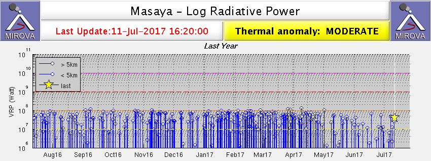 |
Figure 53. Thermal anomaly data identified by the MIROVA system at Masaya for the year ending 11 July 2017. Courtesy of MIROVA. |
INETER reported that from 1 to 5 May 2017 fieldwork was conducted with scientists from the University of McGill (Canada) and the Volcanological and Seismological Observatory of Costa Rica (OVSICORI). Measurements of sulfur dioxide (SO2) in the plume emitted by the Santiago crater were carried out using the DOAS Mobile technique, and samples of hydrogen sulfide (H2S), hydrogen bromide (HBr) and bromine chloride (BrCl) were collected to be analyzed by ion chromatography at McGill (figures 54 and 55).
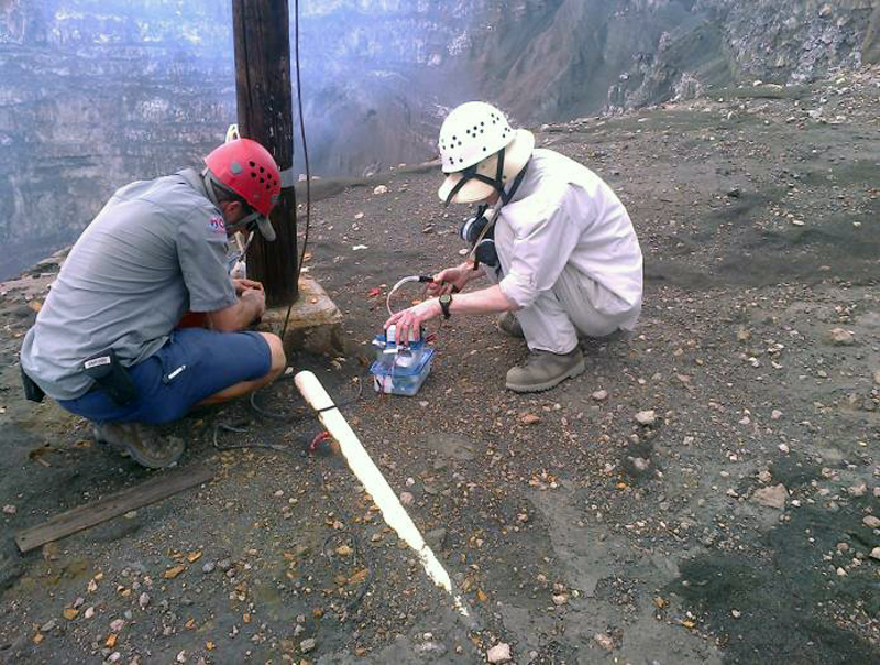 |
Figure 54. Scientists from the University of McGill and OVSICORI installed different equipment for gas measurements near the Santiago crater at Masaya during 1-5 May 2017. Courtesy of INETER (Boletín mensual Sismos y Volcanes de Nicaragua. Mayo, 2017). |
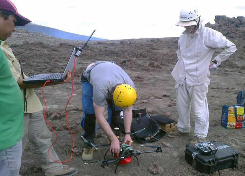 |
Figure 55. Drones were used by University of McGill and OVSICORI scientists to measure sulfur dioxide (SO2) gases at the altitude of the gas plume at Masaya during 1-5 May 2017. Courtesy of INETER (Boletín mensual Sismos y Volcanes de Nicaragua. Mayo, 2017). |
During the INETER field monitoring that took place on 22 May 2017, strong convection of the lake was observed, as were landslides on almost all of the walls. Fumaroles were seen that are possibly not new, but were active due to recent rainfall. The landslides on the W wall of the crater have been occurring since the end of February (figure 56). They are believed by INETER to be caused by undercutting of the walls by lava lake convection (figure 57).
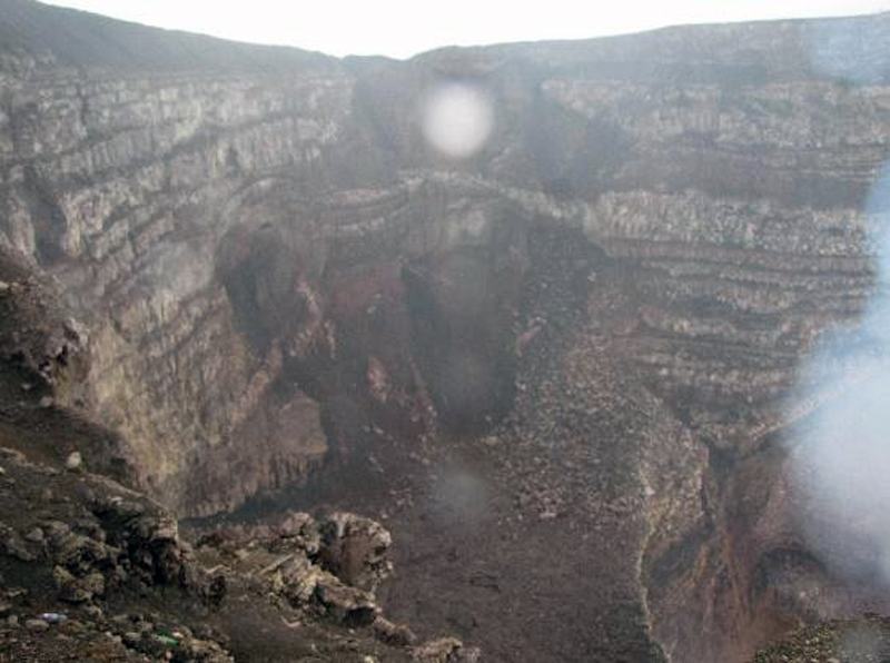 |
Figure 56. Collapse on the W wall of Santiago crater at Masaya reported by Park rangers on 15 May 2017. Courtesy of INETER (Boletín mensual Sismos y Volcanes de Nicaragua. Mayo, 2017). |
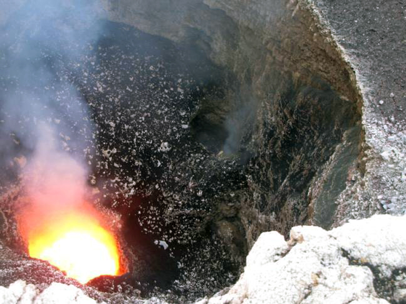 |
Figure 57. Lava lake in Santiago crater of Masaya in May 2017. Courtesy of INETER (Boletín mensual Sismos y Volcanes de Nicaragua. Mayo, 2017). |
References. Rymer, H., van Wyk de Vries, B., Stix, J., and Williams-Jones, G., 1998, Pit crater structure and processes governing persistent activity at Masaya Volcano, Nicaragua. Bull. Volcanol., v. 59, pp. 345-355.
Geological Summary. Masaya volcano in Nicaragua has erupted frequently since the time of the Spanish Conquistadors, when an active lava lake prompted attempts to extract the volcano's molten "gold" until it was found to be basalt rock upon cooling. It lies within the massive Pleistocene Las Sierras caldera and is itself a broad, 6 x 11 km basaltic caldera with steep-sided walls up to 300 m high. The caldera is filled on its NW end by more than a dozen vents that erupted along a circular, 4-km-diameter fracture system. The Nindirí and Masaya cones, the source of observed eruptions, were constructed at the southern end of the fracture system and contain multiple summit craters, including the currently active Santiago crater. A major basaltic Plinian tephra erupted from Masaya about 6,500 years ago. Recent lava flows cover much of the caldera floor and there is a lake at the far eastern end. A lava flow from the 1670 eruption overtopped the north caldera rim. Periods of long-term vigorous gas emission at roughly quarter-century intervals have caused health hazards and crop damage.
Information Contacts: Instituto Nicaragüense de Estudios Territoriales (INETER), Apartado Postal 2110, Managua, Nicaragua (URL: http://webserver2.ineter.gob.ni/vol/dep-vol.html); MIROVA (Middle InfraRed Observation of Volcanic Activity), a collaborative project between the Universities of Turin and Florence (Italy) supported by the Centre for Volcanic Risk of the Italian Civil Protection Department (URL: http://www.mirovaweb.it/); Hawai'i Institute of Geophysics and Planetology (HIGP) - MODVOLC Thermal Alerts System, School of Ocean and Earth Science and Technology (SOEST), Univ. of Hawai'i, 2525 Correa Road, Honolulu, HI 96822, USA (URL: http://modis.higp.hawaii.edu/); Washington Volcanic Ash Advisory Center (VAAC), Satellite Analysis Branch (SAB), NOAA/NESDIS OSPO, NOAA Science Center Room 401, 5200 Auth Rd, Camp Springs, MD 20746, USA (URL: http://www.ospo.noaa.gov/Products/atmosphere/vaac/, archive at: http://www.ssd.noaa.gov/VAAC/archive.html); Sistema Nacional para la Prevencion, Mitigacion y Atencion de Desastres, (SINAPRED), Edificio SINAPRED, Rotonda Comandante Hugo Chávez 50 metros al Norte, frente a la Avenida Bolívar, Managua, Nicaragua (URL: http://www.sinapred.gob.ni/).