Report on Wrangell (United States) — October 2017
Bulletin of the Global Volcanism Network, vol. 42, no. 10 (October 2017)
Managing Editor: Edward Venzke.
Research and preparation by Paul Berger.
Wrangell (United States) Occasional steam plumes and wind-blown ash, but no recent eruptive activity
Please cite this report as:
Global Volcanism Program, 2017. Report on Wrangell (United States) (Venzke, E., ed.). Bulletin of the Global Volcanism Network, 42:10. Smithsonian Institution. https://doi.org/10.5479/si.GVP.BGVN201710-315020
Wrangell
United States
62.006°N, 144.017°W; summit elev. 4278 m
All times are local (unless otherwise noted)
A previous report on Wrangell noted that the heat flux from a crater on the N side of the summit rim had increased by an order of magnitude between 1964 and 1986 (SEAN 11:04). Wrangell has several active fumarolic areas in its summit caldera. These fumaroles frequently produce steam plumes that are mistaken for eruptive activity. The Alaska Volcano Observatory (AVO) receives several reports per year from pilots and local residents who observe larger than normal steam clouds over the summit. Although there have been some events possibly involving wind-blown ash, there have been no recent confirmed eruptions.
Activity during 1996-2000. According to Neal and McGimsey (1997), a pilot reported a suspicious cloud around 18 January 1996 rising about 1.5 km near Wrangell. The National Weather Service (NWS) confirmed that a robust steam plume had been visible over the volcano for several weeks.
McGimsey and Wallace (1999) reported that, on 3 June 1997, a pilot reported steam rising from the summit. On 24 June another report described a steam plume rising about 200 m above the summit. This sighting was not observed on satellite imagery.
McGimsey and others (2004) reported that on the morning of 14 May 1999, a NWS observer in Gulkana (about 75 km WNW) reported anomalous steam emissions containing a small amount of ash. During clear weather at approximately 0930 local time, a rapidly billowing grayish-white plume rose to about 900 m above the N summit crater. The observer stated that at this time of year, on clear days, a small, wispy, steam plume is usually visible above Wrangell in the early morning, and dissipates by early afternoon. On this day, the plume developed quickly, was abnormally voluminous, and had a grayish color.
A pilot had also observed the activity and noticed that more "dirt" surrounded the N crater than usual, and that on the upper part of the Chestnina Glacier high on the SW flank, blocks of ice were chaotically jumbled (higher relief between blocks) and that the glacier surface was much more crevassed than he had ever previously seen. He also observed that one of two known fumaroles at 3,350 m elevation on the S flank, which typically issue steam through ice holes, was surrounded by a sizeable patch of bare rock, a new development since his last recent flight over the area. The pilot further reported that he had observed no sign of flowage or melting events high on the flank, but that he had not flown over the lower reaches of the glacier. As of 1700 that day the NWS observer in Gulkana could still see a small steam plume and with binoculars could see that the snow around the summit area appeared to be light gray and that this was a definite color contrast and not an effect from shadows.
According to Neal and others (2004), a Trans Alaska Pipeline worker reported an unusually strong, white steam plume on 18 March 2000 between 0500 and 0600 local time. Later that day a National Park Service (NPS) employee in Kenny Lake reported robust steaming during the previous month from multiple sources on the SW flank between approximately 600-1,500 m below the summit. AVO found no anomalies in satellite imagery and concluded that no significant unrest had occurred.
Activity during 2002-2003. Neal and others (2005) reported that on 1 August 2002, AVO received several calls reporting a dark cloud drifting downwind from the general summit area and a dark deposit high on its snow-covered flank. AVO seismologists, however, checked data from the Wrangell seismic network and, based on a lack of correlative seismicity, concluded that no eruption or explosion had occurred. AVO also consulted with a local NPS geologist, who suggested that high winds had lofted fine-grained material exposed in the area near the summit fumaroles. On 4 August, an AVO geologist traveling in the area verified that a diffuse, light gray stripe extended a short distance down the flank of the volcano, emanating from the W caldera rim.
Subsequently, a local resident presented AVO with a video showing the waning portion of the event and his written observations. The witness described multiple dark billowing black ash puffs; the wind was from the E and the puffs were not rising over the summit. By the time he had returned to a good vantage point to film, about 10-12 minutes later, the billowing had stopped and the puffs had "turned a more grayish color."
According to the authors, the video showed discrete, light gray "puffs" that moved downwind and retained their individual integrity. There were no other weather clouds in the vicinity. A light gray, relatively motionless and irregular-shaped cloud sat near the caldera rim. A breeze could be observed at ground level (indicated by motion in the trees) but at altitude, clouds were not shearing rapidly. High on the snow-covered flank, a gray-colored swath extended from a high point at the W caldera rim near Wrangell's crater. The end of the video footage showed two distinct dark areas on the rim that were normally snow-covered. The resident's son reported a similar but more vigorous event on 2 August at about the same time of the day, but AVO received no further inquiries or reports.
AVO concluded that no volcanic process of significance had occurred. However, the authors stated "these observations remain enigmatic: lack of any seismicity would seem to preclude a phreatic or magmatic eruption and yet the pulsatory, 'puffing' nature of the dirty clouds is difficult to reconcile with a wind phenomenon."
McGimsey and others (2005) reported that NPS geologist Danny Rosenkrans contacted AVO with photographs taken by a local resident on 11 June 2003 showing an unusual towering cloud over the summit. Although the authors acknowledged that it could simply have been a common cumulus cloud, they noted that the absence of cumulus clouds in the area over nearby Mts. Drum and Sanford suggested that calm weather conditions permitted steam emissions from the known summit fumaroles to coalesce and form the plume-like cloud.
McGimsey and others (2005) also reported that on 18 September 2003 the Center Weather Service Unit called with a Pilot Weather Report of a steam plume 600-700 m over the volcano. The pilot reported no ash or sulfur smell. AVO scientists checked satellite imagery and seismograms and found nothing unusual.
Activity during 2007. McGimsey and others (2011) stated that an M 8.2 earthquake in the Kurile Islands on 13 January 2007 may have triggered seismicity at Wrangell and other nearby volcanoes. There were no reports of steaming immediately following this event; however, two weeks later, on 7 February, a relatively large local earthquake was recorded on the Wrangell network that was followed another two weeks later by steaming from the summit. According to the authors, this was the first report of Wrangell steaming in several years.
The authors also mentioned additional episodes of steaming in March 2007. On 25 March, a resident living about 80 km N of the summit reported a strong sulfur odor, an occurrence the resident stated was rare in his 15 years of living in the area. Earlier that day, the Wrangell network had recorded several multi-station seismic events. The authors note that several months later, local residents sent AVO photographs taken on 20 June of steaming from Wrangell and a deposit of ash extending from the W crater many hundreds of meters down the SW flank (figure 2). According to the authors, this ash was likely redistributed from the summit craters by strong winds. No anomalous seismic activity was observed.
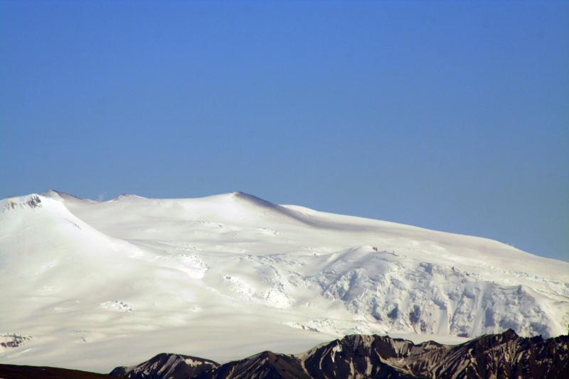 |
Figure 2. View of the northwest flank of Wrangell volcano on 20 Jun e2007 showing a dark stripe of probable redistributed ash extending from West Crater. The photo was taken at Mile 20 of the Tok Cutoff (Hwy 1), between Gakona and Slana. Strong north winds were reported. Note the steam plume rising from skyline saddle near North Crater (left). Photo by Norma Traw, courtesy of AVO. |
Activity during 2010. A report by Neal and others (2014) noted that no significant eruptive activity or restlessness had occurred in 2010. However, the authors stated that AVO had received a report of possible vapor emission from the summit area. In May 2010, a single LIDAR swath taken during a summit overflight by glaciologists from the Geophysical Institute, University of Alaska-Fairbanks, depicted the topography of North Crater, a long-known fumarolic source on the NW rim of the ice-filled summit caldera. According to the authors, there are several secondary depressions, including a complex, kidney-bean shaped pit about 20 m deep and 200 m across, located in the center of North crater. This result is broadly consistent with previously recorded surveys of North Crater using photogrammetric techniques.
Neal and others (2014) reported that in early November 2010, a long-time local resident called AVO to report "more activity at the Mount Wrangell summit than he had ever seen before." He sent AVO several images of the volcano taken on 2 November and assured AVO that when the activity in question began, there had been no weather clouds in the area. He noted about ten "bursts" from the summit and said this was unusual compared to the typical steady emissions often seen. The authors stated that AVO reviewed available seismic and satellite data and, finding no evidence of volcanic signals, concluded that the phenomenon was most likely weather-related.
Activity during 2012. According to Herrick and others (2014), no eruptive activity or significant unrest had occurred in 2012, but as in previous years AVO received reports of fumarolic activity high on its flanks. The authors noted that, because of seismic station outages, AVO had removed Wrangell from its monitored list on 27 January 2012, where it remained for at least through the rest of the year. At the same time, the Aviation Color Code and Volcano Alert Level were downgraded from Green/Normal to Unassigned.
Herrick and others (2014) reported that on 11 March 2012, local observers noted "puffs of steam." AVO analysts using satellite images detected small plumes above known fumaroles. On 20 March 2012, a citizen noticed unusually rigorous steaming and described it as looking like "a pressure cooker shot through with nails." Steam rose from both the summit and a location on the SW flank at an elevation of about 3 km. Other calls to AVO registered concern about the significant plumes. Because no other evidence of significant volcanic unrest was detected, AVO concluded these events were likely generated by normal fumarolic activity.
References. Neal, C., and McGimsey, R. G., 1997, 1996 volcanic activity in Alaska and Kamchatka: Summary of events and response of the Alaska Volcano Observatory: U.S. Geological Survey Open-File Report OF 97-0433, 34 p.
McGimsey, R. G., and Wallace, K. L., 1999, 1997 volcanic activity in Alaska and Kamchatka: Summary of events and response of the Alaska Volcano Observatory: U.S. Geological Survey Open-File Report OF 99-0448, 42 p.
McGimsey, R. G., Neal, C. A., and Girina, O., 2004, 1999 Volcanic activity in Alaska and Kamchatka: Summary of events and response of the Alaska Volcano Observatory: U.S. Geological Survey Open-File Report OF 2004-1033, 49 p.
McGimsey, R. G., Neal, C. A., Dixon, J. P., Malik, N., and Chibisova, M., 2011, 2007 Volcanic activity in Alaska, Kamchatka, and the Kurile Islands: Summary of events and response of the Alaska Volcano Observatory: U.S. Geological Survey Scientific Investigations Report 2010-5242, 110 p. Available online at http://pubs.usgs.gov/sir/2010/5242/.
Neal, C. A., McGimsey, R. G., and Chubarova, O., 2004, 2000 Volcanic activity in Alaska and Kamchatka: Summary of events and response of the Alaska Volcano Observatory: U.S. Geological Survey Open-File Report OF 2004-1034, 37 p.
Neal, C. A., McGimsey, R. G., and Girina, O., 2005, 2002 Volcanic activity in Alaska and Kamchatka: Summary of events and response of the Alaska Volcano Observatory: U.S. Geological Survey Open-File Report OF 2004-1058, 55 p., available online at http://pubs.usgs.gov/of/2004/1058/.
McGimsey, R. G., Neal, C. A., and Girina, O., 2005, 2003 volcanic activity in Alaska and Kamchatka: Summary of events and response of the Alaska Volcano Observatory: U.S. Geological Survey Open-File Report 2005-1310, 62 p., http://pubs.usgs.gov/of/2005/1310/.
McGimsey, R. G., Neal, C. A., Dixon, J. P., Malik, N., and Chibisova, M., 2011, 2007 Volcanic activity in Alaska, Kamchatka, and the Kurile Islands: Summary of events and response of the Alaska Volcano Observatory: U.S. Geological Survey Scientific Investigations Report 2010-5242, 110 p. Available online at http://pubs.usgs.gov/sir/2010/5242/.
Neal, C. A., Herrick, J., Girina, O. A., Chibisova, M., Rybin, A., McGimsey, R. G., and Dixon, J., 2014, 2010 Volcanic activity in Alaska, Kamchatka, and the Kurile Islands - Summary of events and response of the Alaska Volcano Observatory: U.S. Geological Survey Scientific Investigations Report 2014-5034, 76 p., http://dx.doi.org/10.3133/sir20145034/.
Herrick, J. A., Neal, C. A., Cameron, C. E., Dixon, J. P., and McGimsey, R. G., 2014, 2012 Volcanic activity in Alaska: Summary of events and response of the Alaska Volcano Observatory: U.S. Geological Survey Scientific Investigations Report 2014-5160, 82p., http://dx.doi.org/10.3133/sir20145160/.
Geological Summary. Mount Wrangell is one of the world's largest continental-margin volcanoes, with a diameter of 30 km at 2,000 m elevation. The andesitic shield volcano has produced fluid lava flows as long as 58 km and contains an ice-filled caldera 4-6 km in diameter and 1 km deep, located within an older 15-km-wide caldera. Most of the edifice was constructed during eruptions between about 600,000 and 200,000 years ago. Formation of the summit caldera followed sometime between about 200,000 and 50,000 years ago. Three post-caldera craters are located at the broad summit, along the northern and western caldera rim. A steep-sided flank cinder cone, Mount Zanetti, is located 6 km NW of the summit. The westernmost cone has been the source of infrequent eruptions beginning in the 18th century. Increased heat flux in recent years has melted large volumes of ice in the northern crater.
Information Contacts: Alaska Volcano Observatory (AVO), a cooperative program of a) U.S. Geological Survey, 4200 University Drive, Anchorage, AK 99508-4667 USA (URL: https://avo.alaska.edu/), b) Geophysical Institute, University of Alaska, PO Box 757320, Fairbanks, AK 99775-7320, USA, and c) Alaska Division of Geological & Geophysical Surveys, 794 University Ave., Suite 200, Fairbanks, AK 99709, USA (URL: http://dggs.alaska.gov/).