Report on Dempo (Indonesia) — December 2017
Bulletin of the Global Volcanism Network, vol. 42, no. 12 (December 2017)
Managing Editor: Edward Venzke.
Research and preparation by Jackie Gluck.
Dempo (Indonesia) Phreatic explosion from the crater lake generates a dense ash plume in November 2017
Please cite this report as:
Global Volcanism Program, 2017. Report on Dempo (Indonesia) (Venzke, E., ed.). Bulletin of the Global Volcanism Network, 42:12. Smithsonian Institution. https://doi.org/10.5479/si.GVP.BGVN201712-261230
Dempo
Indonesia
4.016°S, 103.121°E; summit elev. 3142 m
All times are local (unless otherwise noted)
Activity at Dempo on Sumatra in recent years has consisted of brief phreatic eruptions, most recently single-day events on 25 September 2006 (BGVN 34:03) and 1 January 2009 (BGVN 34:01). There were no additional reports from the Center of Volcanology and Geological Hazard Mitigation (CVGHM), also known as Pusat Vulkanologi dan Mitigasi Bencana Geologi (PVMBG), until a brief episode of unrest in late April 2015, Another typically short phreatic explosion took place on 9 November 2017.
Activity during 2015. On 29 April the Alert Level was raised to 2 (on a scale of 1-4) by PVMBG following observations of diffuse white-gray plumes on 27 April rising to 50 m above the crater. Seismicity had increased during April compared to the previous month (figure 5). A Detik news report on 30 April quoted the PVMBG Head of the Western Volcano Field of Observation and Investigation, Hendra Gunawan, as saying that there had been tremor recorded over the previous four days. No ashfall was reported by PVMBG, and a phreatic eruption was only mentioned in the 29 April notice as a potential danger.
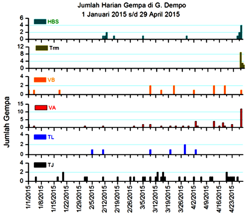 |
Figure 5. Seismicity recorded at Dempo from 1 January to 29 April 2015. The types of earthquakes reported are HBS (Hembusan, puff or emission events), Trm (tremor), VB (shallow volcanic type B), VA (volcanic type A), TL (local tectonic), and TJ (distant tectonic). Courtesy of PVMBG. |
Observers reported that during 1 June-9 September 2015 no plumes were seen and seismicity was low. On 10 September PVMBG lowered the Alert Level to 1.
Activity during 2017. Staff at the PVMBG Dempo observation post reported that no plumes rose from the crater during January and February 2017, but some diffuse white plumes during 1 March-4 April rose no higher than 50 m. Seismicity increased significantly above background levels from 21 March to 4 April (figure 5). On 5 April PVMBG raised the Alert Level to 2 based on visual and seismic data, but did not report any phreatic eruptions.
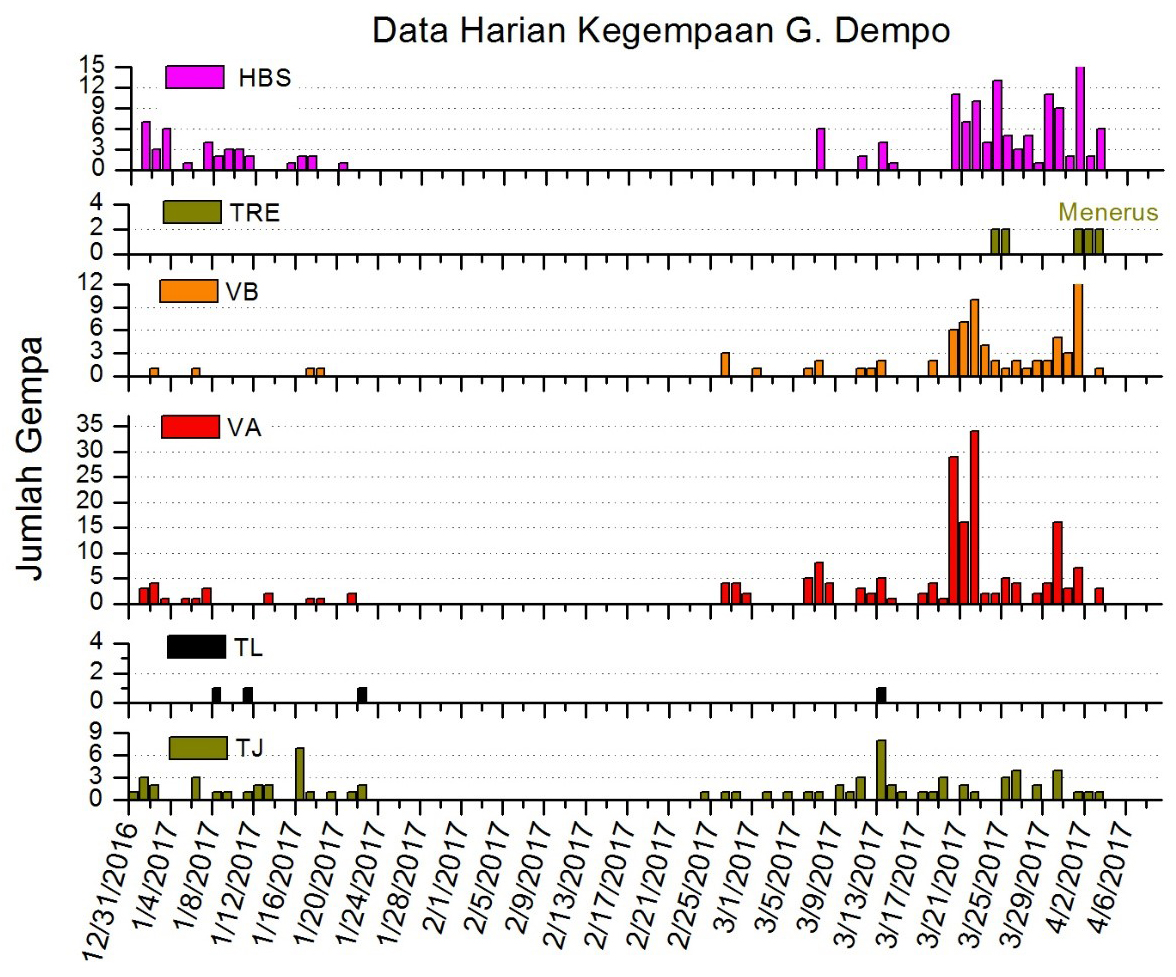 |
Figure 6. Seismicity recorded at Dempo from 31 December 2016 to 6 April 2017. The types of earthquakes reported are HBS (Hembusan, puff or emission events), TRE (tremor), VB (shallow volcanic type B), VA (volcanic type A), TL (local tectonic), and TJ (distant tectonic). Courtesy of PVMBG. |
According to PVMBG a three-minute-long phreatic eruption began at 1651 on 9 November 2017 and generated a dense ash plume that rose to 4.2 km altitude, about 1 km above the crater rim, and drifted S. Ashfall and sulfur gases were reported in villages on the S flanks, but there was no damage to property or injuries. The Alert Level remained at 2, with a 3-km-diameter exclusion zone; the Aviation Color Code was at Yellow.
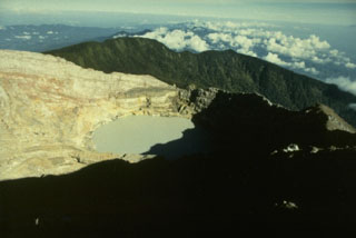
Geological Summary. Dempo is a stratovolcano that rises above the Pasumah Plain of SE Sumatra. The andesitic complex has two main peaks, Gunung Dempo and Gunung Marapi, constructed near the SE rim of a 3-km-wide amphitheater open to the north. The high point of the older Gunung Dempo crater rim is slightly lower, and lies at the SE end of the summit complex. The taller Marapi cone was constructed within the older crater. Remnants of seven craters are found at or near the summit, with volcanism migrating WNW over time. The active 750 x 1,100 m active crater cuts the NW side of the Marapi cone and contains a 400-m-wide lake at the far NW end. Eruptions recorded since 1817 have been small-to-moderate explosions that produced local ashfall.
Information Contacts: Pusat Vulkanologi dan Mitigasi Bencana Geologi (PVMBG, also known as Indonesian Center for Volcanology and Geological Hazard Mitigation, CVGHM), Jalan Diponegoro 57, Bandung 40122, Indonesia (URL: http://www.vsi.esdm.go.id/); Detiknews (URL: https://news.detik.com/).