Report on Ambae (Vanuatu) — February 2018

Bulletin of the Global Volcanism Network, vol. 43, no. 2 (February 2018)
Managing Editor: Edward Venzke.
Edited by A. Elizabeth Crafford.
Ambae (Vanuatu) New eruption begins in early September 2017, forcing evacuation of thousands
Please cite this report as:
Global Volcanism Program, 2018. Report on Ambae (Vanuatu) (Crafford, A.E., and Venzke, E., eds.). Bulletin of the Global Volcanism Network, 43:2. Smithsonian Institution. https://doi.org/10.5479/si.GVP.BGVN201802-257030
Ambae
Vanuatu
15.389°S, 167.835°E; summit elev. 1496 m
All times are local (unless otherwise noted)
Ambae (formerly called Aoba) is a large basaltic shield volcano in the New Hebrides arc that has generated periodic phreatic and pyroclastic explosions originating in the summit crater lakes Manaro Lakua and Voui during the last 25 years; the central edifice with the active summit craters is also commonly referred to as Lombenben, Manaro Voui, or simply the Manaro volcano. From late November 2005 to mid-February 2006 explosions from Lake Voui resulted in the formation of a pyroclastic cone in the lake. By late November 2006 the side of the cone was breached, and its central crater filled with lake water (figure 30, BGVN 31:12). The Vanuatu Meteorology and Geo-Hazards Department (VMGD) reported intermittent increases in degassing activity between 2006 and August 2017, and minor ash emissions during June-July 2011 and August 2016. An explosive eruption from a new pyroclastic cone in the lake began in mid-September 2017 and lasted through mid-November. This report summarizes activity between 2010 and the new eruption in September 2017 and provides details for the eruption through December 2017, with information provided primarily by the Vanuatu Geohazards Observatory of VMGD, the Wellington Volcanic Ash Advisory Center (VAAC), and satellite data from several sources.
Local ashfall around the pyroclastic cone in Lake Voui during June-July 2011 and August 2016 were the only eruptive events between February 2006 and September 2017, although intermittent SO2 emissions were noted throughout the period. Renewed explosive activity was reported beginning on 6 September 2017. Lava was first observed on 22 September emerging from a vent at the summit of the pyroclastic cone. Ash plumes and fountaining lava persisted for a few weeks as the pyroclastic cone increased in size. Activity became more intermittent by mid-October, but explosions still produced ash plumes; the highest was reported at 9.1 km altitude. Pulses of thermal activity suggesting lava flows continued through early November. The last ash emission of the year was reported on 23 November 2017, after which only steam and gas were noted.
Activity during 2010-August 2017. After several years of quiet since early 2006, substantial gas plumes were observed beginning in December 2009 and the Volcanic Alert Level was raised to 1 (on a 0-5 scale). Plumes of gas emissions were observed during 6-11 April 2010, and steam emissions were photographed during 3-4 June 2010 (figure 32).
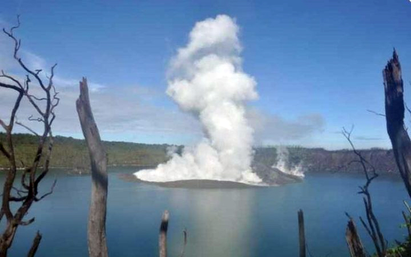 |
Figure 32. Steam plumes rose from the crater of the pyroclastic cone in Lake Voui at Ambae on 4 June 2010. Courtesy of Vanuatu Meteorology and Geo-Hazards Department (VMGD) (Vanuatu Volcanic Activity Bulletin No. 1-Ambae activity, Monday, July 11th, 2011). |
Sulfur dioxide emissions were often elevated, and plumes were identified multiple times with satellite instruments during 2011 (figure 33). Local ashfall around the crater of the pyroclastic cone in Lake Voui was reported after explosions and seismicity on 4 June 2011; additional explosions occurred on 10 July 2011. Compared to January 2010, the cone was significantly eroded when photographed on 12 July 2011.
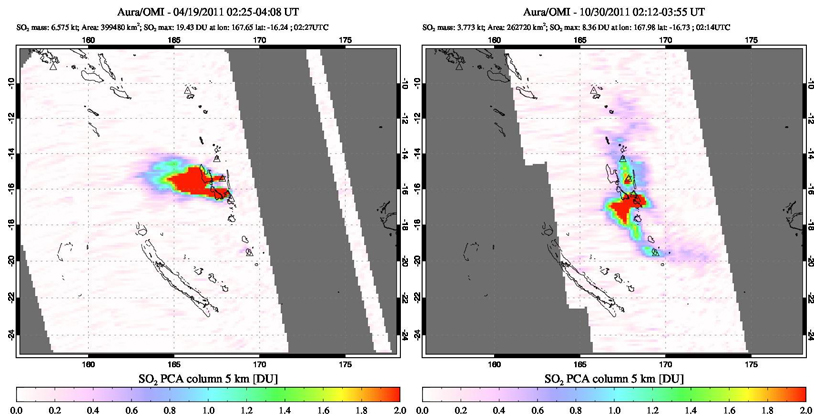 |
Figure 33. SO2 plumes from Ambae and Ambrym volcanoes during 2011. SO2 plumes drifted W from both Ambae (N) and Ambrym (S) on 19 April 2011 (left). The SO2 plume from Ambae is small but also distinct from the much larger plume from Ambrym on 30 October 2011 (right). It is often difficult to distinguish between the two sources of the SO2. Courtesy of NASA Goddard Space Flight Center. |
While no ash emissions or explosions were reported during 2012 from Ambae, SO2 plumes were recorded by satellite instruments every month except June and August (figure 34). Villagers in Ambanga reported a "phase of minor activity" beginning in December 2012. Increased SO2 plumes were recorded in satellite data during December as well (figure 35). Nearby Ambrym often produces large SO2 plumes which obscure SO2 emissions from Ambae.
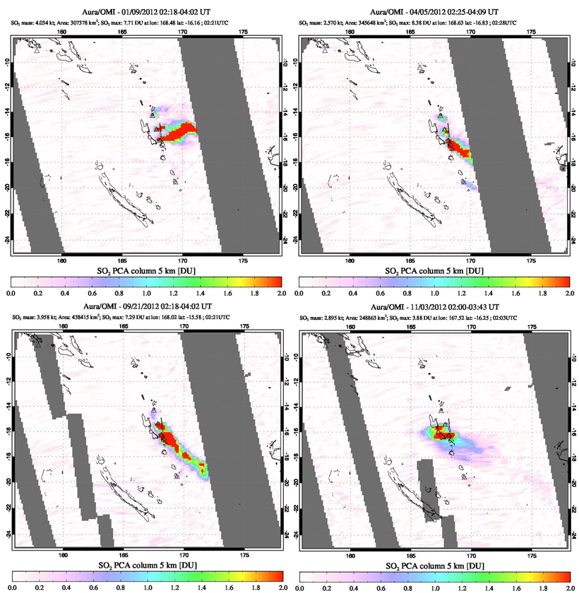 |
Figure 34. SO2 plumes were recorded every month of 2012 except June and August. Plumes emerging from Ambae are often difficult to distinguish from larger plumes released from Ambrym, located 100 km S. Data from the OMI instrument on the Aura satellite on both 9 January and 5 April (top images) showed SO2 emissions from three volcanos in the New Hebrides arc; from N to S, Gaua, Ambae, and Ambrym. Plumes from both Ambae and Ambrym drifted SE on 21 September (lower left), and smaller plumes drifted W from both Ambrym and Ambae on 3 November (lower right). Courtesy of NASA Goddard Space Flight Center. |
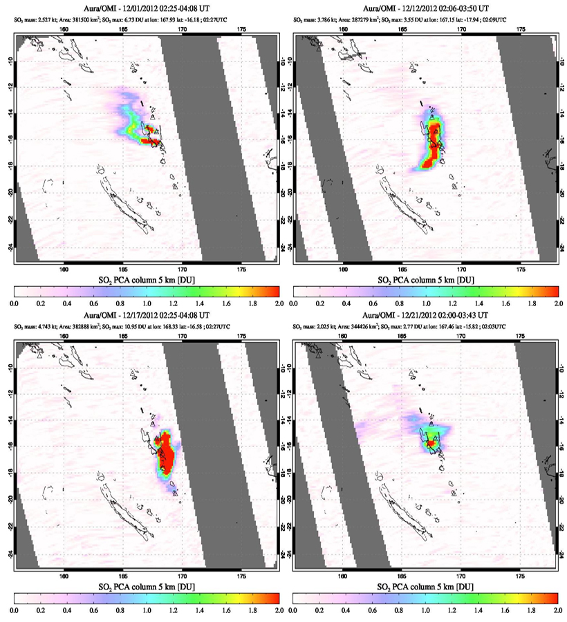 |
Figure 35. Increased gas emissions from Ambae were reported by nearby residents in Ambanga during December 2012. More frequent SO2 emissions were also recorded by the OMI satellite instrument including on 1 (top left), 12 (top right), 17 (bottom left), and 21 (bottom right) December 2012. Courtesy of NASA, Goddard Space Flight Center. |
Site observations during 30 January-2 February 2013 confirmed continuing degassing at Lake Voui, and remnants of the old pyroclastic cone still visible in the lake. The Aura satellite instrument detected SO2 emissions a number of times throughout 2013-2016 (figure 36), and VMGD noted continuing unrest multiple times during 2015.
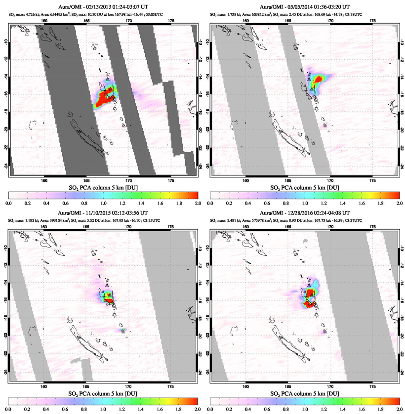 |
Figure 36. Selected SO2 emissions during 2013-2016 at Ambae. SO2 emissions drifted W from both Ambae (N) and Ambrym (S) on 13 February 2013 (top left). A rare image of an SO2 plume from Ambae with no plume from Ambrym was recorded on 5 May 2014 (top right). SO2 emissions were also distinct from each volcano on 10 November 2015 (bottom left) and 28 December 2016 (bottom right). Courtesy of NASA Goddard Space Flight Center. |
VMGD reported that during 18-19 August 2016 a steam plume was accompanied by a small ash emission in the caldera area. The Vanuatu Volcanic Alert Level (VVAL) was raised from 1 to 2 on 21 August 2016 and remained there for just over a year. Changing conditions were first reported by VMGD on 30 August 2017.
Activity during September-December 2017. The Alert Level was raised to 3 on 6 September 2017, indicating that a minor eruption was occurring. A week later VMGD reminded residents of the 3 km danger zone around the lake and added a 1 km exclusion zone within that area (figure 37). Explosive activity began building a new pyroclastic cone in Lake Voui, and ash plumes generated local ashfall on the island.
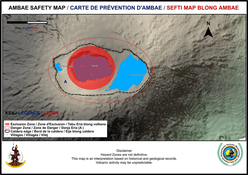 |
Figure 37. "Safety Map" showing hazard zones in the summit area of Ambae, consisting of a Danger Zone A (red oval line) around the summit caldera and a 1-km-radius Exclusion Zone around Manaro Voui. Courtesy of VMGD (Vanuatu Volcano Alert Bulletin No 10-Ambae Activity, Friday September 15th 2017). |
On 22 September 2017, lava was observed at the surface by VMGD staff, there was a MODVOLC thermal alert, and a volcanic ash advisory was issued by the Wellington VAAC. The VAAC report estimated the ash plume observed in satellite data to be at an altitude of 3 km drifting E. On 23 September the VMGD stated that activity had continued to increase, prompting them to raise the VVAL to 4, indicating that a moderate eruption was taking place. They warned that ejecta and gas would affect an area within 6.5 km of Lake Voui, and many communities were at risk from various types of volcanic activity (figure 38). A dense plume of dark ash was photographed on 23 September by airplane travelers going to Ambae (figure 39).
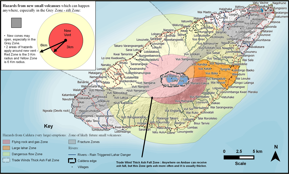 |
Figure 38. Volcanic hazard map for Ambae. On 23 September 2017, VMGD raised the alert level to 4 and warned that ejecta and gas would likely affect an area within 6.5 km of Lake Voui (pink zone). Villages located in the gray and orange areas of the map could see ashfall and other hazards such as lahars and pyroclastic flows. The lighter area outlined with a dashed border indicates where villages would be more susceptible to ashfall and acid rain based on the general wind direction. Courtesy of VMGD (Vanuatu Volcano Alert Bulletin No. 11 - Ambae Activity, Saturday, September 23rd, 2017). |
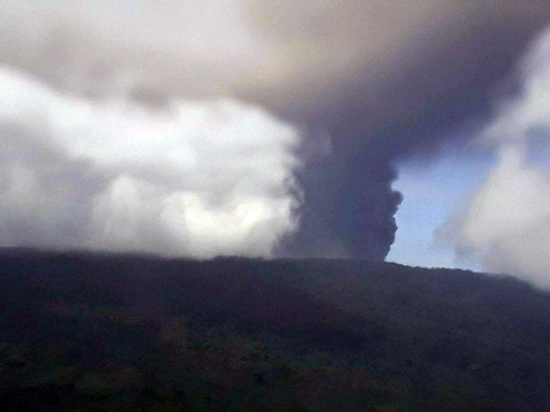 |
Figure 39. Ash emission photographed on 23 September 2017 from an airplane going to Ambae. Courtesy of Batik Bong Shem, Facebook. |
Eruptive activity increased over the next few days. Larger explosions generated ash plumes that caused local ashfall. A photo taken on 24 September showed incandescent ejections and an ash plume rising from the pyroclastic cone (figure 40). The Wellington VAAC reported intermittent emissions that day at 2.4 km altitude drifting N, and again on 26 September at 2.1 km altitude drifting W. The New Zealand Defense Force conducted an overflight on 25 September 2017 and witnessed incandescence at the summit and lava flowing into the lake (figures 41, 42, and 43).
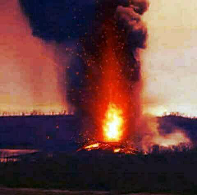 |
Figure 40. An eruption from the pyroclastic cone in Lake Voui at Ambae on 24 September 2017. Courtesy of Yumi Toktok Stret News, Facebook. |
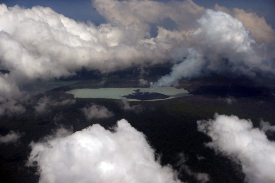 |
Figure 41. The New Zealand Defence Force (NZDF) aerial survey on 25 September 2017 showed large columns of gas, ash, and volcanic rocks emerging from Lake Voui on Ambae. Courtesy of NZDF. |
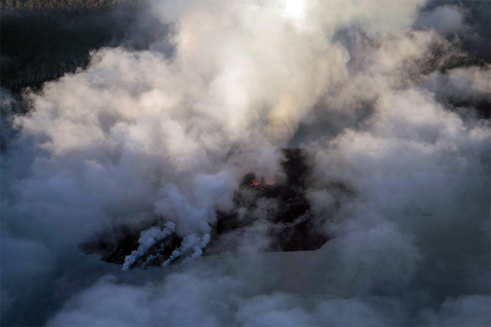 |
Figure 42. Lava flows into Lake Voui at Ambae, causing steam plumes. Incandescence is visible at the cone's summit through the clouds. The photo was likely taken on 25 or 26 September 2017. Posted by Geoff Reid NZ on Facebook on 2 October 2017. |
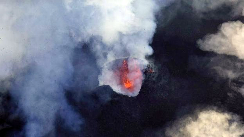 |
Figure 43. Incandescent lava from the crater of the Lake Voui cone was photographed at Ambae on 25 September 2017. Image courtesy of Reuters, reported by BBC. |
A 27 September a news article from ABC.net stated that about 8,000 residents had been evacuated from the northern and southern parts of the island to eastern and western areas. An overflight by the New Zealand Defence Force showed ongoing activity. Multiple MODVOLC thermal alerts were issued nearly every day from 22 September through 7 October.
Photographs and thermal infrared images taken by VMGD during observation flights on 30 September and 1 October 2017 showed explosions of tephra, and lava flowing from small vents into the lake (figures 44-48). The number of vents on the cone varied from 2 to 4 during the observation flights.
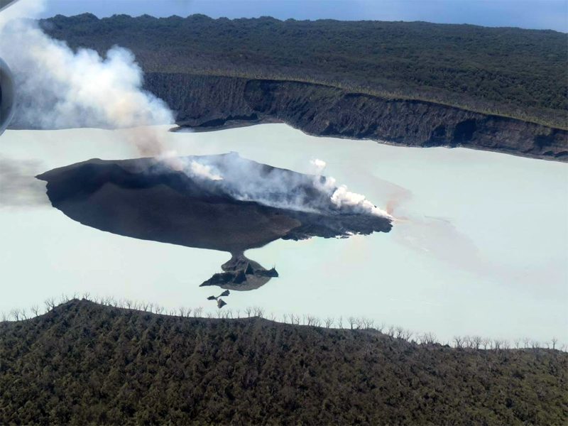 |
Figure 44. Aerial view of the pyroclastic cone that formed in Lake Voui during September in the Ambae summit caldera. The active lava-producing vents are near the center of the island. The blue steaming zone is a lava flow. The white steaming to the right is lava entering the lake. Photo taken on 30 September 2017. Courtesy of VMGB, posted on Facebook 2 October 2017. |
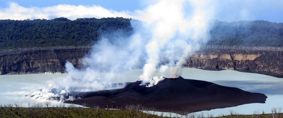 |
Figure 45. The pyroclastic cone in Lake Voui at the summit of Ambae had active steam, ash, and gas emissions, in addition to lava flowing into the lake, on 1 October 2017. Courtesy of VMGD. |
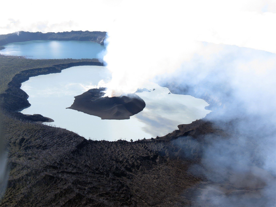 |
Figure 46. Aerial view of the cone that formed in Lake Voui during September 2017 in the summit caldera of Ambae. The Manaro Lakua lake can be seen in the background. The active vents are near the center of the island. The white steaming zone at the far end of the island was caused by lava flows entering the lake. Photo taken on 1 October 2017. Courtesy of VMGB, posted on Facebook 2 October 2017. |
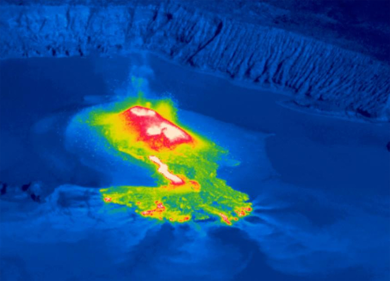 |
Figure 47. Infrared aerial view of the volcanic cone that has formed in Lake Voui during September 2017 near the summit of Ambae Island. The active lava producing vents are the hottest areas near the center of the island (inwhite). The white streak in the foreground is a lava flow. The red areas in the foreground are areas where lava recently entered the lake. The caldera rim at the summit of Ambae is visible in the background. Photo taken on 1 October 2017. Courtesy of VMGB, posted on Facebook, 2 October 2017. |
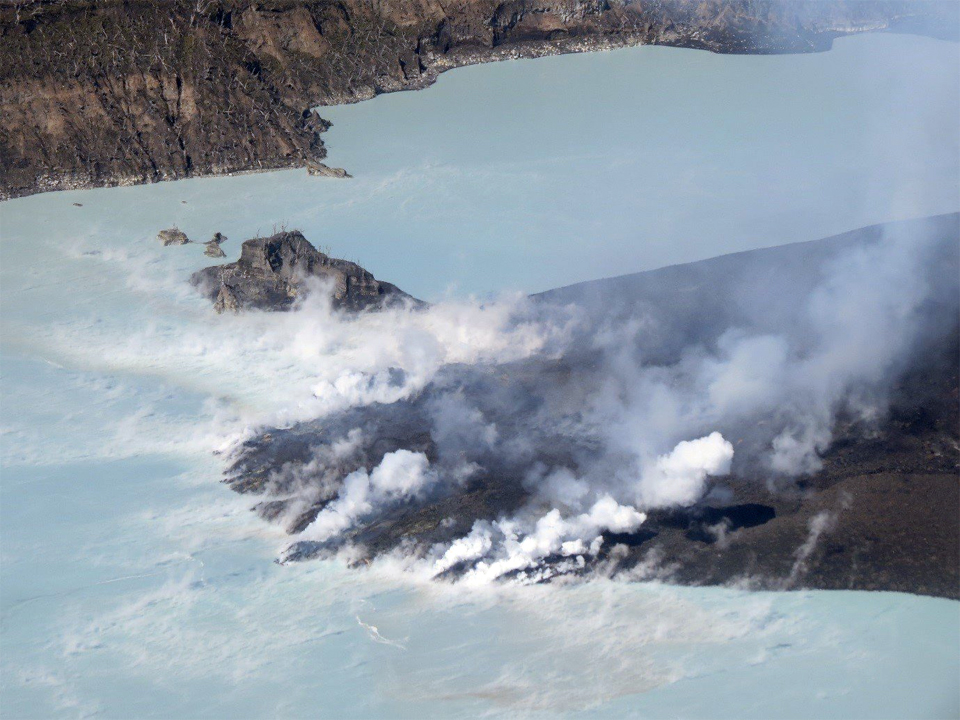 |
Figure 48. Closeup view of a lava flow from the cone entering into Lake Voui at Ambae on 1 October 2017. Courtesy of VMGB, posted on Facebook 2 October 2017. |
On 6 October 2017, the VMGD noted that there was no evidence of the eruption escalating; the Alert Level was lowered to 3 and residents and tourists were reminded to stay outside of the Red Zone, defined as a 3 km radius around the active cone. The Wellington VAAC reported ash emissions on 9 October visible in satellite imagery spreading N of the island as high as 3.7 km altitude. They reported low-level (2.4-4.6 km) ash plumes daily through 15 October. A short-lived eruption on 13 October produced an ash plume clearly visible in satellite imagery that rose to 9.1 km altitude.
Webcam observations and seismic analysis reported on 13 October by VMGD indicated ongoing minor explosive activity and ash emission from vents on the cone in Lake Voui over the previous several days (figure 49). Lava had apparently ceased flowing to the lake. The local population from Ambae and neighboring islands could still hear some of the explosions, see volcanic ash and gas plumes, and see incandescence at night. Multiple MODVOLC thermal alerts were issued on 15 and 16 October, and again during 19-23 October. Wellington VAAC reports during 22-23 October indicated intermittent low-level ash plumes at 2.4-3.7 km altitude moving E.
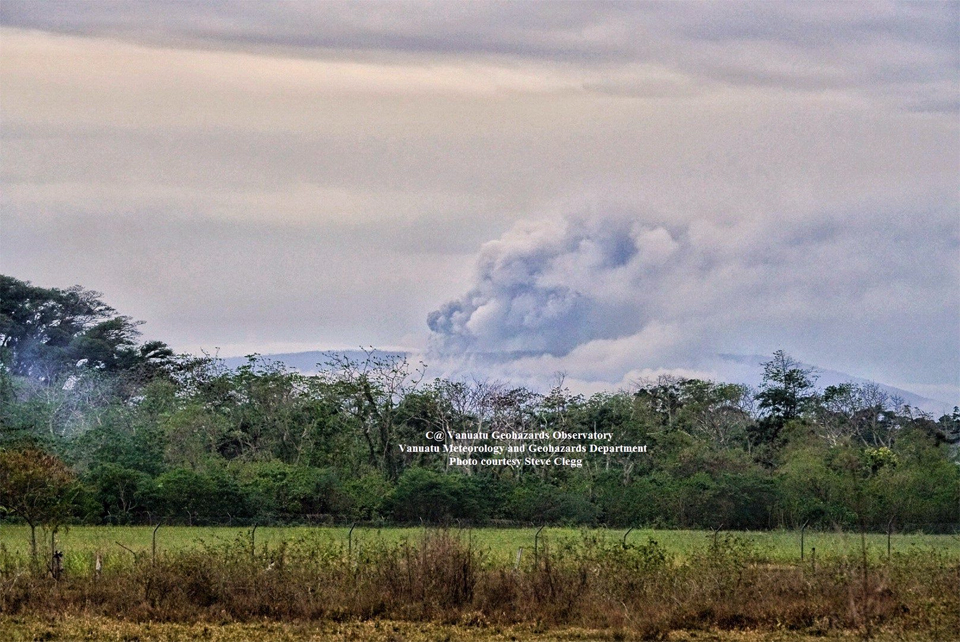 |
Figure 49. An ash plume rises over Ambae island on 12 October 2017 in this photo taken from Santo - Pekoa Airport 65 km W on Espiritu Santo Island. Photo by Steve Clegg, courtesy of VMGD (posted on their Facebook page). |
A new surge of activity created multiple MODVOLC thermal alerts between 27 October and 1 November 2017. The Wellington VAAC reported an ash plume on 29 October at 6.1 km altitude drifting SE. The activity ceased, and the plume dissipated by the end of the day. VMGD reported on 31 October that seismic activity was ongoing, and explosions could be seen in webcam photos; incandescence and explosions were also heard and seen from neighboring islands at night.
Webcam photos from 5 and 6 November showed that ash emissions and incandescent explosions continued (figures 50 and 51). The Wellington VAAC reported an ash emission rising to 4.3 km altitude and drifting W on 5 November. By the next day the altitude of the ash plume had dropped to 2.1 km. This was followed late on 6 November by an ash emission reported at 3.9 km altitude extending 25 km W and SW of the volcano, which continued through the next day. Another emission on 8 November drifted W at 3 km altitude for several hours before dissipating. Fourteen MODVOLC thermal alerts were issued on 5 November, and two more the next day. A final alert on 9 November was the last for 2017.
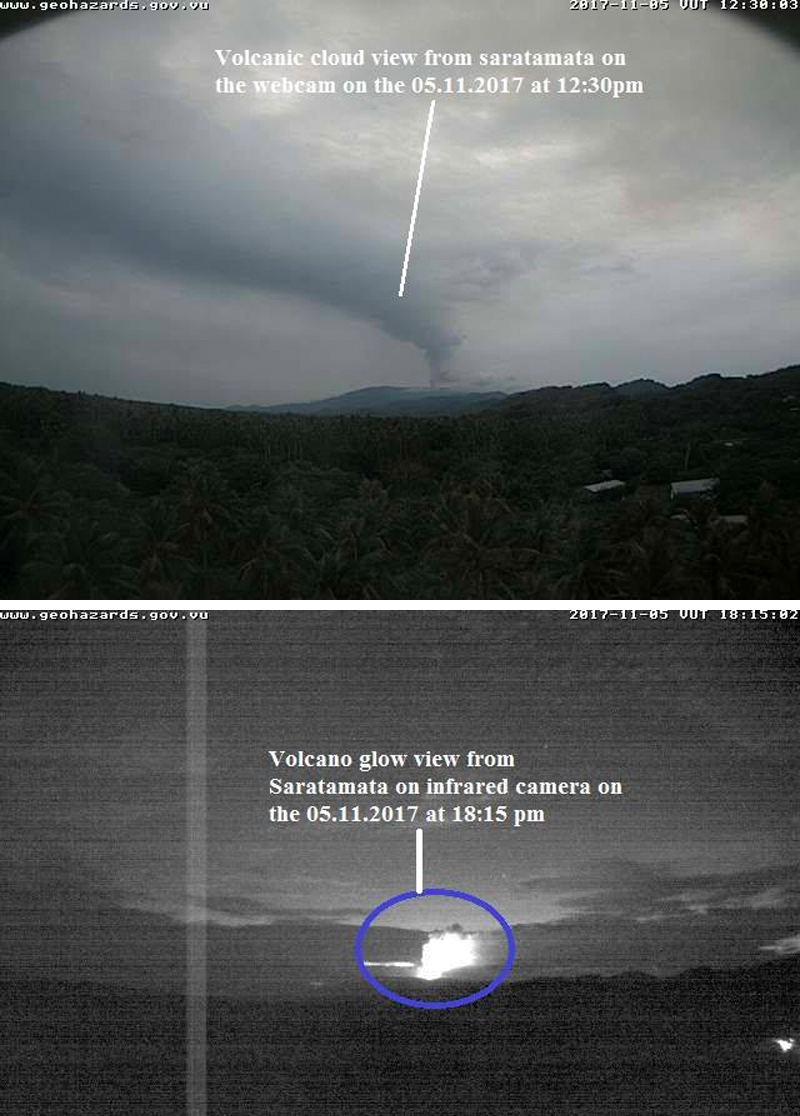 |
Figure 50. Webcam images of Ambae indicate that ash emissions and incandescent explosions were continuing on 5 November 2017. Image taken from the Saratamata webcam located 22 km NE on the NE tip of Ambae Island. Courtesy of VMGD, posted on Facebook 5 November 2017. |
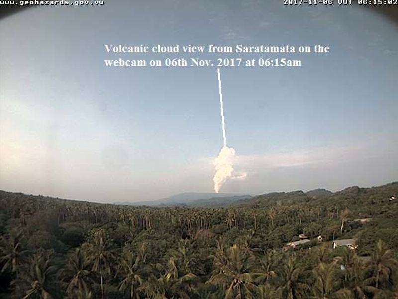 |
Figure 51. Steam and ash emissions were visible from the Saratamata webcam (22 km NE) in the early morning of 6 November 2017. Courtesy of VMGD, posted on Facebook 5 November 2017 (UTC). |
VGO reported on 8 November 2017 that the eruption had been continuing, and photos taken during the first week of the month confirmed that the pyroclastic cone in Lake Voui continued to grow in height and size, with frequent explosions and ash plumes. The Wellington VAAC reported a ground observation of an ongoing minor eruption on 21 November that produced an ash plume that rose to 1.8 km altitude. By the following day, the plume appeared to be mostly steam. A new eruption the next day (23 November) produced a plume estimated at 3.7 km altitude moving W. An ash emission later that day was estimated at 3 km altitude drifting N based on satellite imagery. It had dissipated by the following day, and there were no further VAAC reports issued during 2017.
By 7 December 2017, activity had decreased significantly, and emissions consisted of only steam and gas plumes; VMGD lowered the Alert Level from 3 to 2, and reduced the restricted area to within 2 km of the active vent in Lake Voui, noting that the eruption had ceased. The MIROVA plot of Log Radiative Power at Ambae (Aoba) correlates well with visual and thermal observations of activity between 23 September and early November 2017 (figure 52). Significant quantities of SO2 were released at Ambae during October-December 2017 (figure 53). SO2 emissions continued into December after the ash emissions ceased.
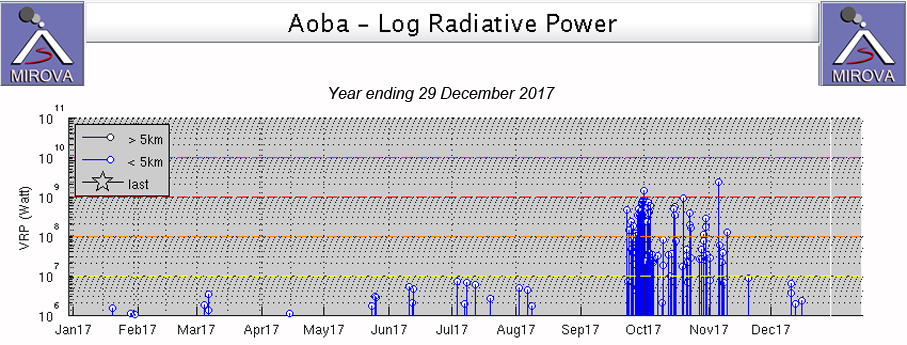 |
Figure 52. The MIROVA plot of Log Radiative Power at Ambae (Aoba) for the year ending on 29 December 2017 correlates well with visual and thermal observations of activity between 23 September and early November 2017. Courtesy of MIROVA. |
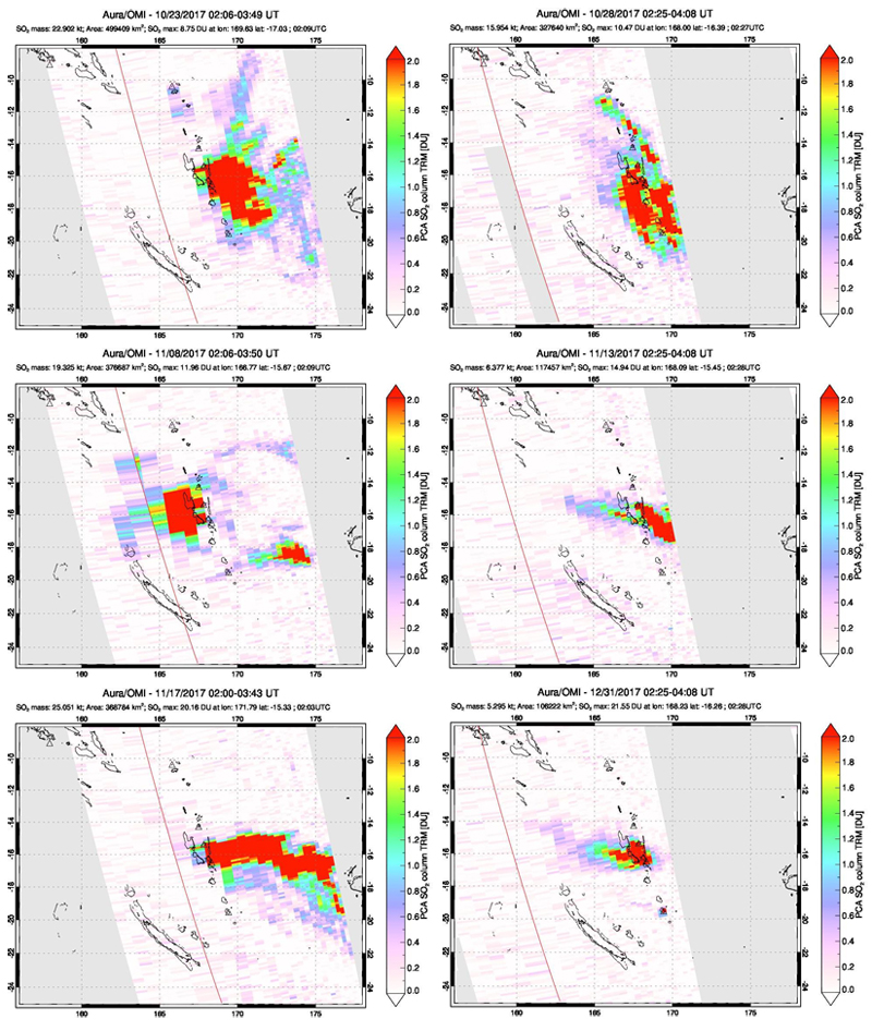 |
Figure 53. Significant quantities of SO2 were released from Ambae during October-December 2017. Variable wind directions seem to create complex patterns of SO2 plumes. Emissions on 23 and 28 October (top), 8, 13, and 17 November (middle row and bottom left) all show plumes that appear to be mostly sourced from Ambae, but some component of source from Ambrym is also likely. By 31 December 2017 (bottom right) SO2 emissions at Ambae were still significant even though no ash emissions had been reported for over a month. Courtesy of NASA Goddard Space Flight Center. |
Geological Summary. The island of Ambae, also known as Aoba, is a massive 2,500 km3 basaltic shield that is the most voluminous volcano of the New Hebrides archipelago. A pronounced NE-SW-trending rift zone with numerous scoria cones gives the 16 x 38 km island an elongated form. A broad pyroclastic cone containing three crater lakes (Manaro Ngoru, Voui, and Manaro Lakua) is located at the summit within the youngest of at least two nested calderas, the largest of which is 6 km in diameter. That large central edifice is also called Manaro Voui or Lombenben volcano. Post-caldera explosive eruptions formed the summit craters about 360 years ago. A tuff cone was constructed within Lake Voui (or Vui) about 60 years later. The latest known flank eruption, about 300 years ago, destroyed the population of the Nduindui area near the western coast.
Information Contacts: Geo-Hazards Division, Vanuatu Meteorology and Geo-Hazards Department, Ministry of Climate Change Adaptation, Meteorology, Geo-Hazards, Energy, Environment and Disaster Management, Private Mail Bag 9054, Lini Highway, Port Vila, Vanuatu (URL: http://www.vmgd.gov.vu/, https://www.facebook.com/VanuatuGeohazardsObservatory/); Hawai'i Institute of Geophysics and Planetology (HIGP), MODVOLC Thermal Alerts System, School of Ocean and Earth Science and Technology (SOEST), Univ. of Hawai'i, 2525 Correa Road, Honolulu, HI 96822, USA (URL: http://modis.higp.hawaii.edu/); MIROVA (Middle InfraRed Observation of Volcanic Activity), a collaborative project between the Universities of Turin and Florence (Italy) supported by the Centre for Volcanic Risk of the Italian Civil Protection Department (URL: http://www.mirovaweb.it/); Wellington Volcanic Ash Advisory Centre (VAAC), Meteorological Service of New Zealand Ltd (MetService), PO Box 722, Wellington, New Zealand (URL: http://www.metservice.com/vaac/, http://www.ssd.noaa.gov/VAAC/OTH/NZ/messages.html); NASA Goddard Space Flight Center (NASA/GSFC), Global Sulfur Dioxide Monitoring Page, Atmospheric Chemistry and Dynamics Laboratory, 8800 Greenbelt Road, Goddard, Maryland, USA (URL: https://so2.gsfc.nasa.gov/); New Zealand Defence Force (URL: http://www.nzdf.mil.nz/); BBC News (URL: http://www.bbc.com/news); ABC News (http://abcnews.go.com/); Batik Bong Shem, Facebook (URL: https://www.facebook.com/batick.shem); Yumi Toktok Stret News, Facebook URL: https://www.facebook.com/ytsnews.today/); Geoff Reid NZ, Facebook (URL: https://www.facebook.com/GeoffReidNZ/).