Report on Aira (Japan) — February 2018

Bulletin of the Global Volcanism Network, vol. 43, no. 2 (February 2018)
Managing Editor: Edward Venzke.
Edited by A. Elizabeth Crafford. Research and preparation by Jackie Gluck.
Aira (Japan) Explosions gradually decrease in frequency during 2015-2016
Please cite this report as:
Global Volcanism Program, 2018. Report on Aira (Japan) (Crafford, A.E., and Venzke, E., eds.). Bulletin of the Global Volcanism Network, 43:2. Smithsonian Institution. https://doi.org/10.5479/si.GVP.BGVN201802-282080
Aira
Japan
31.5772°N, 130.6589°E; summit elev. 1117 m
All times are local (unless otherwise noted)
Sakurajima rises from Kagoshima Bay, which fills the Aira Caldera near the southern tip of Japan's Kyushu Island. Frequent explosive and occasional effusive activity has been ongoing for centuries. The Minamidake summit cone has been the location of persistent activity since 1955; the Showa crater on its E flank has been the most active site since 2006. Tens of explosions and ash-bearing emissions have been occurring monthly for the last several years and were continuous through October 2015. After a three-month break, activity resumed in February 2016 and lasted through August 2016. No further activity was reported through December 2016. The Japan Meteorological Agency (JMA) provided regular reports on activity, and the Tokyo VAAC (Volcanic Ash Advisory Center) issued hundreds of reports about ash plumes during 2015-2016.
The number of explosive events at the Showa crater of Sakurajima increased from January-May 2015. During the period, ash emissions commonly rose 3,000 m above the crater rim, and a few exceeded 4,000 m; tephra was often ejected 1.3 km and as far as 1.8 km from the crater. Incandescence was observed every week; multiple MODVOLC thermal alerts were reported monthly from January-June 2015. The Tokyo VAAC issued 845 reports between 1 January and 14 October 2015. The number of monthly explosions decreased sharply during June-August. Tiltmeter and strainmeter data indicated continuing inflation through mid-August when the inflation rate increased significantly for a brief period. This was followed by deflation for the remainder of 2015. Pyroclastic flows were reported in March, April, and June. Minor emissions occurred at Minamidake crater in May, June, and August. Activity increased at both craters during September, with the first substantial explosion at Minamidake in almost a year. An emission from Showa on 2 November 2015 was noted in a JMA weekly report, but its composition was not described; the last confirmed ash emission of the year was on 14 October 2015.
After three months of quiet, a substantial explosion at Showa in early February 2016 marked the beginning of a new eruptive episode that continued through the end of July, after which explosive activity ceased at Showa for the remainder of the year (figure 49). Minor emissions were reported at Minamidake through August 2016. Pyroclastic flows occurred in April and June from explosions at the Showa crater. Inflation was measured again beginning in April 2016 and continued through December 2016.
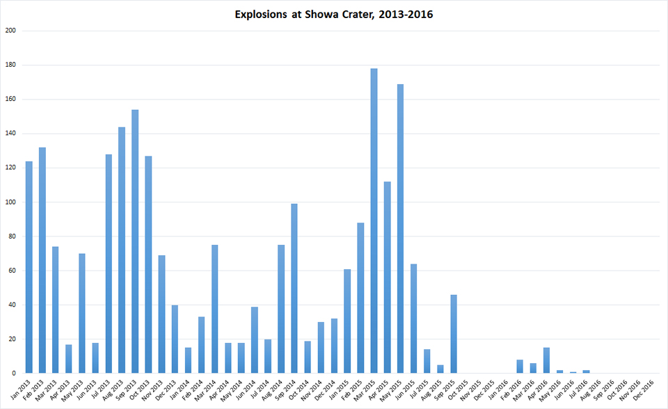 |
Figure 49. Explosions from the Showa crater at Sakurajima, January 2013-December 2016. Data do not include activity at Minamidake crater, or passive (non-explosive) ash or steam emissions from Showa. After many years of multiple monthly explosions, activity decreased in September 2015. A smaller burst of activity occurred from February to July 2016. Data compiled from JMA reports. |
Activity during January-May 2015. JMA reported 61 explosions from the Showa crater during January 2015, twice the number recorded in December 2014 (figure 50). Explosions on 4 and 30 January sent ejecta as far as 1.8 km from the crater. The maximum plume height reported by JMA was 4,000 m above the crater rim on 23 January. Lapilli up to 2 cm in diameter from recent explosions were found in Kurokami (3.5 km E) and Arimura (3 km S) during JMA field visits on 16 and 30 January.
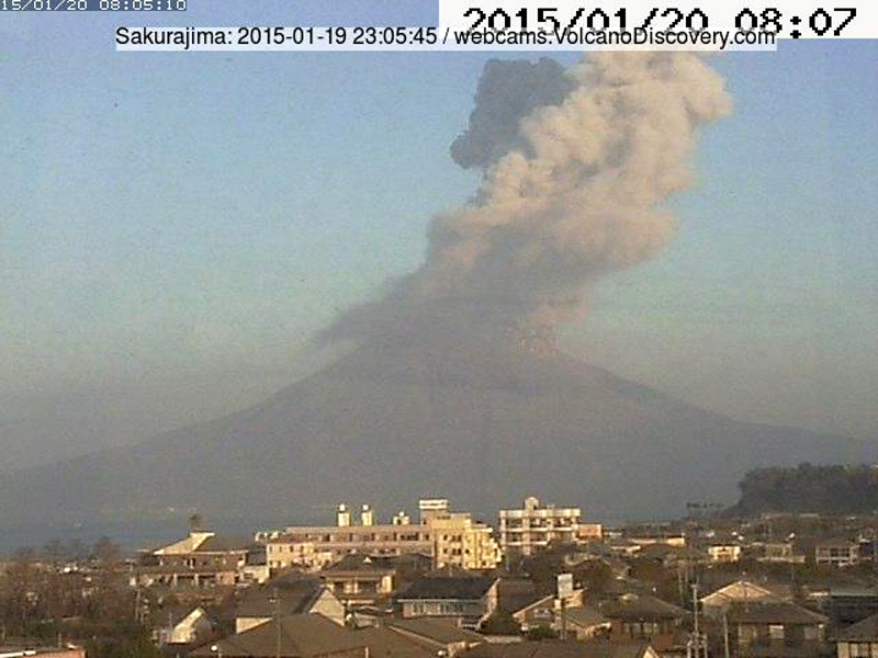 |
Figure 50. An ash emission at Sakurajima on 20 January 2015 was captured by a webcam in Kagoshima (10 km W). Courtesy of Volcano Discovery. |
The number of explosions increased to 88 during February 2015, with events on 21 and 22 February sending tephra 1.8 km from the crater. Plumes rose as much as 3,500 m above the rim during the month. During a field survey on 4 March scientists observed ash deposits with fragments up to 2 cm in diameter, in an area 3 km S of Showa Crater. JMA reported that the largest number of explosions they have recorded in a month, 178, occurred at the crater in March. Numerous plumes rose 3,300 m above the crater. A small pyroclastic flow on 17 March traveled 600 m SE.
Seismicity below the island increased briefly between 31 March and 2 April 2015. An explosion on 17 April sent tephra 1.8 km from the crater rim. Two pyroclastic flows were reported on 18 and 28 April 2015; Showa crater had 112 explosions throughout the month. The pyroclastic flow on 28 April travelled 500 m down the SE flank. The highest ash plume rose 4,000 m on 24 April. JMA calculated that about 1.2 million tons of ash fell during April, the largest monthly amount recorded since 2006.
Several of the 169 explosions at the Showa crater during May 2015 produced ejecta that was deposited up to 1.8 km from the crater. Many explosions had plume heights exceeding 3,000 m. A small emission, rising 200 m, was observed from the Minamidaki crater on 12 May and was the first in several months. JMA scientists observed 2-cm-diameter tephra in the vicinity of Kurojin-cho, Kagoshima-shi on 14 May, likely from an explosion the previous day; significant ashfall covered the ground as well. The highest ash plume of the month rose 4,300 m above the Showa crater on 21 May 2015 (figures 51 and 52).
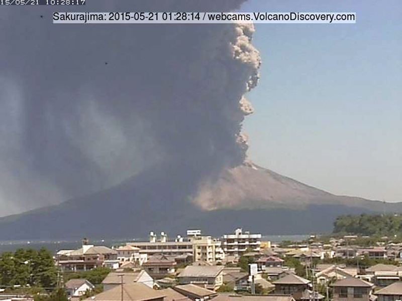 |
Figure 51. An ash plume rose 4,300 m above Sakurajima on 21 May 2015, shown in this webcam image from Kagoshima. Courtesy of Volcano Discovery. |
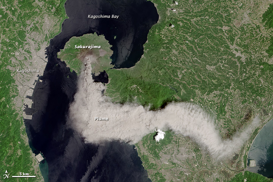 |
Figure 52. A dense plume of ash drifted S and E from Sakurajima on 21 May 2015. This natural-color satellite image was taken by the Operational Land Imager on Landsat 8. Courtesy of NASA Earth Observatory. |
Activity during June-December 2015. Five of the 64 explosions recorded during June produced ejecta that landed up to 1.3 km from the Showa Crater (figure 53). A 3,300-m-high ash plume on 1 June was the highest for the month. After three explosions on 4 June, a small pyroclastic flow traveled 400 m down the E flank. A second small event on 22 June at Minamidake produced a gray plume that rose 200 m.
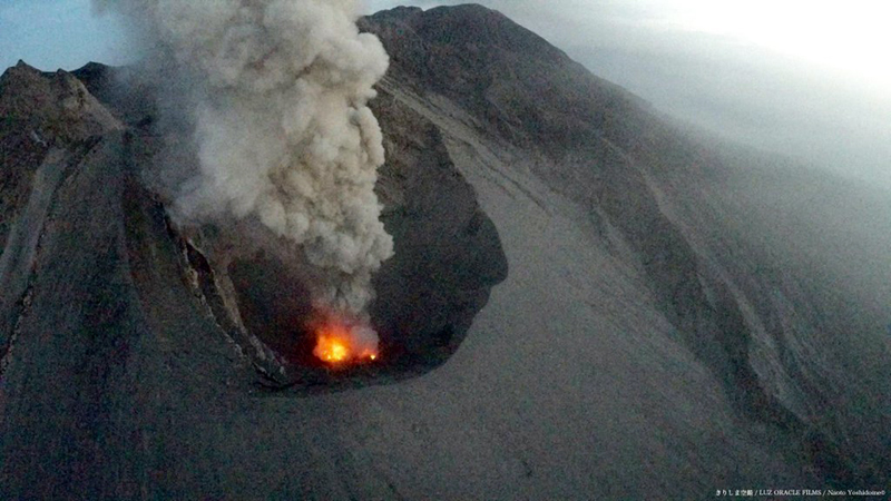 |
Figure 53. Ash rose from Showa Crater at Sakurajima on 9 June 2015. Image taken by a drone managed by Naoto Yoshitome and Krishima Aerial Photography. Courtesy of Naoto Yoshitome, Twitter. |
Activity decreased significantly beginning in July 2015, with 14 explosions reported from the Showa Crater, and declined further during August with only 5 explosions. A small explosion from the Minamidake crater on 16 July sent emissions likely containing ash (described as "non-white") to 200 m. A rapid increase in seismicity directly beneath Minamidake began on 15 August and lasted about 48 hours; along with tiltmeter and strainmeter observations of rapid inflation (figure 54), this led JMA to briefly raise the Alert Level from 3 (Do not approach the volcano) to 4 (Prepare to evacuate) an a scale of 1-5. They lowered it back to 3 on 1 September 2015. Only small explosions with tephra ejected up to 800 m were recorded during the rest of the August. Minor emissions occurred at Minamidake Crater on 30 August.
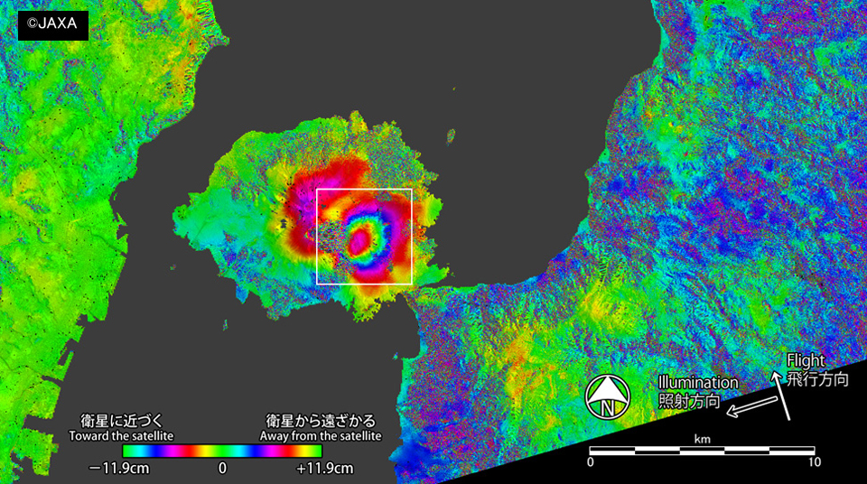 |
Figure 54. An interference image of Sakurajima using PALSAR-2 high-resolution mode (3 m resolution) data comparing displacement between 4 January and 16 August 2015. The data showed a displacement toward the satellite (inflation) of about 16 cm maximum (within the white square), on the E side of the Minamidake summit crater. The synthetic aperture radar (PALSAR - 2) equipped with Daichi 2 (Land Observing Satellite No. 2 "Daichi 2" (ALOS- 2)) can measure the displacement of the ground surface (how much the ground moved) by taking the difference between two sets of observation data. Such an analysis method is called interference SAR analysis (or interferometry, InSAR). The color changes represent the differences in the two observations, a pattern of green to red to blue indicates movement of the surface towards the satellite (inflation); a pattern of green to blue to red indicates movement away from the satellite (deflation). Courtesy of JAXA (http://www.eorc.jaxa.jp/ALOS-2/img_up/jpal2_sakurajima_20150816-17.htm). |
Incandescence at the Showa Crater was observed several times during September 2015; 46 explosive events were reported. The first significant explosions at the Minamidake summit crater since 7 November 2014 occurred on 13 and 28 September. The 28 September plume rose to 2,700 m above the crater rim. Tiltmeter data indicated no additional inflation since the rapid ground deformation of 15-16 August. The last explosive event of 2015 reported by JMA at the Showa crater was on 17 September and at the Minamidaki crater on 29 September.
The Tokyo VAAC reported an ash emission on 14 October 2015 that rose to 1.8 km and drifted SW. This was the last VAAC report until 5 February 2016. No explosions were recorded at the Showa crater in October, but minor ash emissions were reported on 14, 15, 21, 22, and 30 October. No activity was observed at Minamidake. Data from continuous GNSS (Global Navigation Satellite System) observations suggested that deflation began after the 15 August rapid inflation event.
A minor emission was reported by JMA from the Showa crater on 2 November 2015, the last emission reported for the year. After not having explosive activity since late September, JMA lowered the Alert Level to 2 (Do not approach the crater) on 25 November, reducing the exclusion area to 1 km around the two craters. Only steam plumes rising 50-200 m above the Showa crater and 50-600 m above the Minamidake crater were observed during December 2015.
Aerial observation on 2 December 2015 revealed 100-m-high steam plumes around the floor of the Showa crater. Thermal observations showed high heat flow around the edges and at the center of the crater floor, unchanged since the previous observation in August 2015; 200-m-high steam plumes around the Minamidake crater prevented observation of the crater floor.
Activity during 2016. No explosive activity was observed at Showa or Minamidake craters from October 2015 to 5 February 2016. JMA raised the Alert Level back to 3 after a substantial explosion on 5 February sent incandescent tephra up to 1.8 km from the Showa crater; lightning was observed in the ash cloud (figure 55). The Tokyo VAAC reported that an ash plume visible in satellite imagery was at 3 km altitude drifting SE. Multiple explosions continued from the Showa crater for the rest of February with ash plumes rising to 2.2 km above the crater, and tephra was frequently ejected 1.3 km from the crater. Four MODVOLC thermal alerts in February were the only alerts for 2016. At the Minamidake summit crater, minor emissions occurred on 8, 9, and 20 February with plumes rising 800 m above the crater rim.
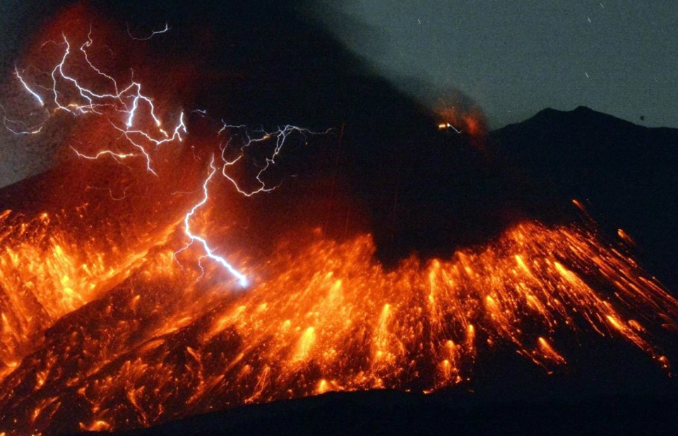 |
Figure 55. Incandescent tephra explodes from Showa crater at Sakurajima on 5 February 2016 after three months of inactivity. Photo by Kyoto News/AP. Courtesy of the Washington Post. |
Eight explosions at the Showa crater were reported by JMA, and six at the Minamidake summit crater during March 2016. Ash plumes at Minamidake on 4, 8, and 11 March rose 1,600-1,900 m above the crater rim; on 25 and 26 March they rose 2,000 m. Minor emissions were also noted on 14 and 15 March. Three explosions from the Showa Crater on 26 March sent ash plumes 2,700 m high (figure 56); tephra as large as 8 mm in diameter was found in areas 4 km E.
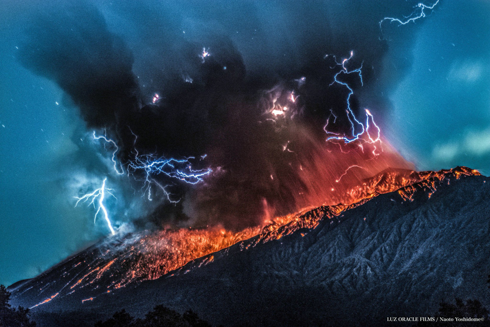 |
Figure 56. Multiple explosions on 26 March 2016 at Sakurajima sent tephra as large as 8 mm in diameter as far as 4 km from Minamidake crater. Image taken from a drone managed by Naoto Yoshidome. Courtesy of Naoto Yoshidome, Twitter. |
Activity increased during April 2016 with 51 emission events that included 15 explosions at Showa, and JMA reported inflation again after several months of stability. Reports of falling tephra, 2 cm in diameter, came from a town 3 km S after explosions were witnessed during 1-3 April. On 1 April, an explosion at Minamidake summit crater produced an ash plume which rose 800 m above its crater rim; another on 3 April rose 1,700 m. Minor emissions also occurred at Minamidake on 5, 6, and 9 April. Explosions on 6 and 8 April at Showa sent ash plumes 3,500-3,700 m high and tephra 1.3 km. During the 8 April explosion at Showa, a small pyroclastic flow traveled 400 m down the E flank, the first since June 2015. A 2,200-m-high ash plume rose from Showa crater on 17 April. Minor emissions that rose 800 m were detected at Minamidake on 20 and 28 April. Two explosions occurred on 27 April at Showa, followed by additional explosions on 28, 29, and 30 April; the events generated ash plumes that rose 3,000 m. Pyroclastic flows were generated during the events of 28 and 30 April; they each flowed about 500 m, SE and E, respectively.
A large explosion at the Showa crater on 1 May sent an ash plume to 4,100 m above the crater rim (figure 57). It was the first time since 21 May 2015 that a plume rose higher than 4,000 m. At the Minamidake summit crater, ash emissions on 1 and 13 May rose 3,500 and 3,700 m, respectively, the first plumes at Minamidake over 3,000 m since October 2009. An explosion on 8 May at Showa sent an ash plume over 3,300 m above the crater rim, and tephra reached 1,300 m from the crater. Numerous ash emissions continued throughout the month, some with plumes rising to 3,500 m. The Tokyo VAAC issued 26 reports between 13 and 22 May. Activity diminished toward the end of the month, but minor inflation continued.
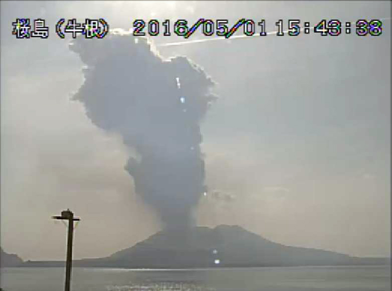 |
Figure 57. An explosive eruption at Sakurajima's Showa Crater on 1 May 2016 sent an ash plume 4,100 m above the crater that drifted SE. It was the highest plume in the last year. Taken with the "Cattle Root" webcam, courtesy of JMA (May 2016 Monthly Sakurajima report). |
Multiple ash emissions in early June 2016 produced plumes as high as 2,000 m above the Showa crater rim. An explosion on 3 June produced a pyroclastic flow that traveled 400 m SE, and tephra that was ejected 800 m from the crater. An emission at the Minamidake crater on 3 June rose 1,500m high. No further explosive activity was reported for June; only a minor emission from the Showa crater on 29 June. During the month, the Tokyo VAAC issued only six reports (during 2-3 June).
Two explosive events were recorded at Showa crater in July 2016. An explosion occurred on 2 July that produced a 1,200-m-high ash plume and sent large blocks 800 m from the crater. A substantial explosion on 26 July at Showa sent blocks 800 m from the crater, and produced an ash plume that rose 5,000 m. A minor amount of ashfall on the W and SW flanks of Sakurajima was observed, and ashfall was confirmed in a wide area from Kagoshima City (10 km W) to Hioki City (25 km NW). The Tokyo VAAC reported an ash plume drifting SW at 6.1 km altitude that day.
Minor emissions were observed at the Minamidake crater intermittently throughout August 2016, but no emissions or explosions were reported from Showa. The Tokyo VAAC reported a low-level ash plume on 22 August at 1.2 km altitude drifting 50 km SW (figure 58). This was the last VAAC report for 2016. Although there were no emissions or explosive activity reported from either crater during September-December 2016, inflation of the volcano continued, and thus the Alert Level remained at 3.
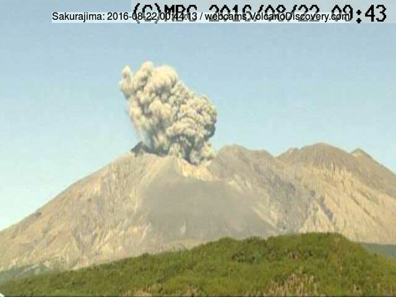 |
Figure 58. An ash emission rose from Sakurajima's Minamidake crater on the morning of 22 August 2016. This was the last reported ash emission of 2016. Taken from the Tarumizu City MBC (Minaminihon Broadcasting Co., Ltd.) webcam no. 14, located about 14 km E. Courtesy of Minaminihon Broadcasting Co., Ltd. (http://www.mbc.co.jp/web-cam/). |
Geological Summary. The Aira caldera in the northern half of Kagoshima Bay contains the post-caldera Sakurajima volcano, one of Japan's most active. Eruption of the voluminous Ito pyroclastic flow accompanied formation of the 17 x 23 km caldera about 22,000 years ago. The smaller Wakamiko caldera was formed during the early Holocene in the NE corner of the caldera, along with several post-caldera cones. The construction of Sakurajima began about 13,000 years ago on the southern rim and built an island that was joined to the Osumi Peninsula during the major explosive and effusive eruption of 1914. Activity at the Kitadake summit cone ended about 4,850 years ago, after which eruptions took place at Minamidake. Frequent eruptions since the 8th century have deposited ash on the city of Kagoshima, located across Kagoshima Bay only 8 km from the summit. The largest recorded eruption took place during 1471-76.
Information Contacts: Japan Meteorological Agency (JMA), Otemachi, 1-3-4, Chiyoda-ku Tokyo 100-8122, Japan (URL: http://www.jma.go.jp/jma/indexe.html); Tokyo Volcanic Ash Advisory Center (VAAC), 1-3-4 Otemachi, Chiyoda-ku, Tokyo, Japan (URL: http://ds.data.jma.go.jp/svd/vaac/data/); Hawai'i Institute of Geophysics and Planetology (HIGP), MODVOLC Thermal Alerts System, School of Ocean and Earth Science and Technology (SOEST), Univ. of Hawai'i, 2525 Correa Road, Honolulu, HI 96822, USA (URL: http://modis.higp.hawaii.edu/); NASA Earth Observatory, EOS Project Science Office, NASA Goddard Space Flight Center, Goddard, Maryland, USA (URL: http://earthobservatory.nasa.gov/); Japan Aerospace Exploration Agency (JAXA) (URL: http://global.jaxa.jp/); Associated Press (URL: http://www.ap.org/); Tom Pfeiffer, Volcano Discovery (URL: http://www.volcanodiscovery.com/ ); Naoto Yoshidome, Twitter (URL: https://twitter.com); Minaminihon Broadcasting Co., Ltd (MBC). (http://www.mbc.co.jp/web-cam/).