Report on Fuego (Guatemala) — February 2018

Bulletin of the Global Volcanism Network, vol. 43, no. 2 (February 2018)
Managing Editor: Edward Venzke.
Edited by A. Elizabeth Crafford.
Fuego (Guatemala) Seven eruptive episodes during July-December 2017
Please cite this report as:
Global Volcanism Program, 2018. Report on Fuego (Guatemala) (Crafford, A.E., and Venzke, E., eds.). Bulletin of the Global Volcanism Network, 43:2. Smithsonian Institution. https://doi.org/10.5479/si.GVP.BGVN201802-342090
Fuego
Guatemala
14.4748°N, 90.8806°W; summit elev. 3799 m
All times are local (unless otherwise noted)
Guatemala's Volcán de Fuego was continuously active throughout 2017, and has been erupting vigorously since 2002; historical observations of eruptions date back to 1531. These eruptions have resulted in major ashfalls, pyroclastic flows, lava flows, and damaging lahars. Reports of activity are provided by the Instituto Nacional de Sismologia, Vulcanología, Meteorología e Hidrologia (INSIVUMEH), and aviation alerts of ash plumes are issued by the Washington Volcanic Ash Advisory Center (VAAC). Satellite data from NASA, NOAA, and other sources provide valuable information about heat flow and gas emissions.
Activity remained high at Fuego throughout July-December 2017. Background levels of activity included frequent explosions (4-6 per hour) with incandescent material rising 150 m above the summit and sending blocks 200 m down the flanks. Block avalanches commonly traveled down the major ravines for hundreds of meters. Ash plumes regularly rose 500-1,000 m above the summit (4.3-4.8 km altitude); ashfall affected communities SW of the summit within 15 km every week. During the multiple short-lived (48-hour or less) eruptive episodes, the hourly explosion rates increased significantly (6-12 per hour), and incandescent material often rose 300 m above the summit; one or more lava flows would also travel more than a kilometer down major ravines. Higher ash plumes (often rising to 5-6 km altitude) during the eruptive episodes sent ash plumes drifting hundreds of kilometers in various directions causing ashfall in cities tens of kilometers away in various directions. Pyroclastic flows often accompanied the eruptive episodes. Seven episodes were reported by INSIVUMEH during July-December 2017 (table 17); they are clearly discernible as periods of higher heat flow in the MIROVA thermal anomaly data (figure 73) as well.
Table 17. Eruptive episodes at Fuego during July-December 2017. Information provided primarily by INSIVUMEH. Some ash plume information is from the Washington VAAC.
| Dates | Episode | Ash plume height | Ash plume drift | Ashfall areas | Lava flow distances | Lava flow drainages | Pyroclastic flows |
| 11-12 Jul 2017 | 6 | 5.1 km | 35 km W | 10-20 km WSW | 2.3 km, 1.7 km | Las Lajas, Santa Teresa | -- |
| 07-08 Aug 2017 | 7 | -- | 20 km W | 10-20 km W | 1.5 km, 700 m | Ceniza, Santa Teresa | -- |
| 19-21 Aug 2017 | 8 | 6.1 km | 75 km W, SW, WNW | 20 km WSW | 1.4 km, 1.2 km | Ceniza, Santa Teresa (Seca) | Santa Teresa |
| 12-13 Sep 2017 | 9 | 4.6 km | 65 km N | 10-20 km WSW | 1.3 km | Seca (Santa Teresa) | Seca (Santa Teresa) |
| 27-28 Sep 2017 | 10 | 4.7 km | 25 km W | More than 30 km N, E | 800 m, 500 m | Seca, Las Lajas | -- |
| 05-07 Nov 2017 | 11 | 4.8 km | 25 km W, SW | 8-12 km SW | 1.2 km, 800 m | Seca, Ceniza | -- |
| 10-11 Dec 2017 | 12 | 5.0 km | 20 km S, SW | 20 km S, SW | 1.5 km | Seca, Taniluyá, Ceniza | -- |
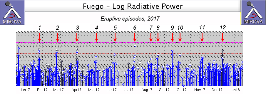 |
Figure 73. MIROVA thermal anomaly data for Fuego for 2017 shows the continuing activity that included intermittent pulses of high-heat-flow from twelve defined eruptive episodes shown by red arrows. Courtesy of MIROVA. Eruptive episodes defined by INSIVUMEH. |
Activity during July 2017. Activity increased at Fuego during July 2017, compared with the previous month. INSIVUMEH reported that explosions per hour increased during 6-7 July from 4-7 to 7-10; a lava flow also traveled 1.5 km down Las Lajas ravine. Incandescent material was ejected 100-200 m above the crater rim and caused avalanches of material that traveled down the Ceniza (SSW), Taniluyá (SW), Santa Teresa (SW), and Trinidad (S) drainages (figure 74). Ash plumes during 7-9 July caused ashfall in Santa Sofía (12 km SW), Morelia (9 km SW), Panimaché I and II (8 km SW), El Porvenir (8 km ENE), Sangre de Cristo (8 km WSW), and possibly San Pedro Yepocapa (8 km N).
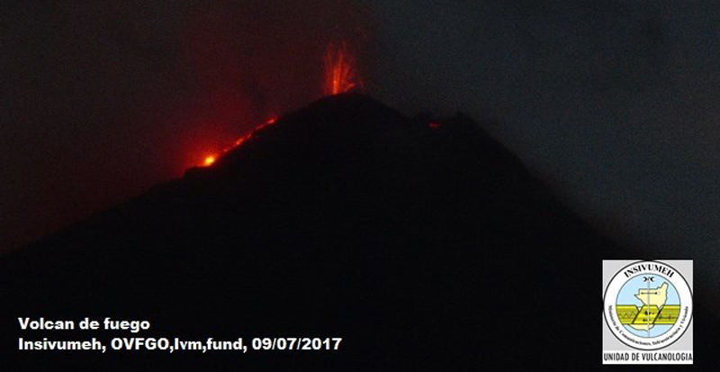 |
Figure 74. Incandescent material was ejected over a hundred meters above the summit of Fuego and blocks of material traveled hundreds of meters down the flank on 9 July 2017. Courtesy of INSIVUMEH and OVFGO (Reporte Semanal de Monitoreo: Volcán Fuego (1402-09), Semana del 08 al 14de julio 2017). |
The Washington VAAC reported dense ash emissions seen in satellite data on 10 July extending WNW 60 km from the summit at 4.6 km altitude. They noted that ashfall was reported 10 km SW from the summit the following morning. The 6th eruptive episode of the year occurred on 11-12 July 2017. Explosions generated ash plumes that rose as high as 1.3 km above the crater and drifted 35 km W, and shock waves rattled nearby structures. Ash fell in areas to the SW. Two lava flows were fed by lava fountains 150-250 m high; one flow traveled 2.3 km down the Las Lajas drainage and another traveled 1.7 km down the Santa Teresa (SW) drainage. The increased activity levels lasted for about 31 hours, with tens of explosions. Weak-to-moderate explosions continued afterwards, generating ash plumes that rose 850 m and drifted 6 km W.
Multiple explosions continued generating ash plumes and block avalanches during 13-14 July. On 16 July, a 30-m-wide, 2-m-deep, hot lahar descended tributaries of the Pantaleón (W) drainage, carrying blocks more than 2 m in diameter, branches, and tree trunks. The lahars again overtook the road between communities on the SW flank, isolating the village of Sangre de Cristo (8 km WSW) and the Palo Verde estate. The Washington VAAC estimated that the ash plumes released early on 16 July rose to 5.2 km altitude, and drifted SE from the summit. By afternoon they had risen to 5.8 km and were drifting SW, extending about 75 km. Explosions during 17-18 July produced dense ash plumes that drifted 15 km W and NW causing ashfall in Panimache, Morelia, and Santa Sofía. Satellite imagery on 19 July showed an ash plume extending 65 km WNW of the summit in a narrow band at 4.3 km altitude. Similar plumes were reported daily between 19-23 July at 4.3-4.9 km altitude drifting generally W up to about 50 km before dissipating (figure 75).
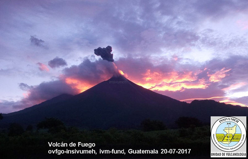 |
Figure 75. Ash emissions were reported almost daily from Fuego during July 2017. A small pulse of ash on 20 July was captured on the Panimaché I webcam (10 km SW) in this view looking NE in the early morning. Courtesy of OVFGO-INSIVUMEH (Reporte Semanal de Monitoreo: Volcán Fuego (1402-09), Semana del 15 al 21 de julio 2017). |
Activity during August 2017. MODVOLC thermal alerts that were issued on 28 and 30 July confirmed the continuing incandescent summit activity which produced block avalanches down the major drainages. Multiple daily alerts were also issued during 15 days of August. Coordinadora Nacional Para la Reduccion de Desastres (CONRED) reported increased activity on 4 August that included 300-m-high ejections of incandescent material and a lava flow that traveled 600 m down the Ceniza ravine. During 7-8 August two lava fountains rose 150 m high, prompting INSIVUMEH to announce the seventh effusive episode at Fuego in 2017. The fountains fed lava flows, 1.5 km and 700 m long, in the Ceniza and the Santa Teresa ravines (figure 76). Explosions (occurring at a rate of 6-8 per hour) produced ash plumes that drifted 20 km W, causing ashfall in Panimache, Morelia, Santa Sofía, El Porvenir, and Yepocapa. The Washington VAAC also noted increasing ash emissions on 7 August. Weather clouds prevented observations from satellite images on 7 and 8 August, but the VAAC reported a "" strong hotspot in infrared imagery on 8 August. Although the lava flow in the Ceniza drainage remained active, explosive activity decreased to an average of three explosions per hour the following week, with ash emissions rising to 4.4-4.6 km and drifting 10 or more km W and SW, bringing ashfall to communities on the W and SW flank.
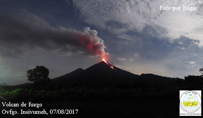 |
Figure 76. A lava flow at Fuego during eruptive episode 7 descends the SE flank on 7 August 2017. Courtesy of OVFGO-INSIVUMEH (Reporte Semanal de Monitoreo:, Volcán Fuego (1402-09), Semana del 5 al 11 de agosto 2017). |
Activity intensified again during 19-20 August, when constant explosions generated ash plumes that rose 2.3 km above the crater and drifted more than 50 km W and SW. INSIVUMEH reported that the eighth effusive episode at Fuego in 2017 began on 20 August and lasted for about 48 hours. Two lava fountains, each 300 m high, fed lava flows that traveled 1.4 km SSW down the Ceniza ravine and 1.2 km W down the Seca (Santa Teresa) ravine (figure 77). Incandescent block avalanches occurred throughout the crater. Pyroclastic flows (figure 78) were concentrated in the Santa Teresa ravine, possibly filling the drainage with deposits (similar to activity from 5 May) and increasing the chances for lahars. A bright hotspot was visible in satellite imagery from 19-21 August. Seismicity remained elevated through 21 August. During 21 August, the Washington VAAC reported the ash plume near 5.5 km altitude extending 75 km WNW. A remnant cloud of ash was detected in satellite imagery over 200 km WNW of the summit in extreme SE Mexico late on 21 August.
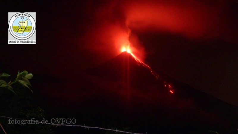 |
Figure 77. Incandescent explosions and block avalanches descend the SE flank of Fuego during eruptive episode 8, 19-21 August 2017 in this view from the Panimaché I webcam. Courtesy of OVGFO-INSIVUMEH (Reporte Semanal de Monitoreo: Volcán de Fuego (1402-09), Semana del 19 al 25 de agosto 2017). |
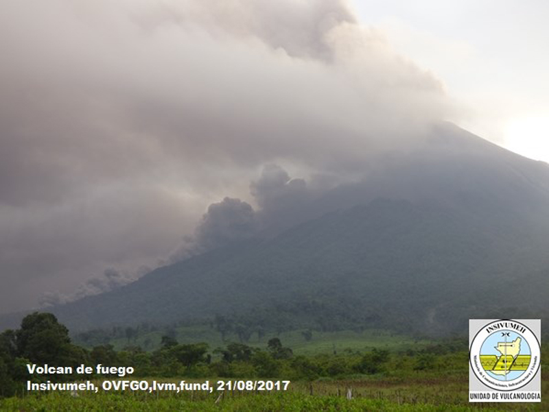 |
Figure 78. A pyroclastic flow descends the Santa Teresa ravine at Fuego during eruptive episode 8 on 21 August 2017 in this view from the Panimaché I webcam. Courtesy of OVGFO-INSIVUMEH (Reporte Semanal de Monitoreo: Volcán de Fuego (1402-09), Semana del 19 al 25 de agosto 2017). |
INSIVUMEH reported that on 25 August multiple lahars descended the Pantaleón, Cenizas, El Jute, and Las Lajas drainages on Fuego's W, SSW, and SE flanks. The lahar in the Pantaleón river (fed by the Santa Teresa and El Mineral rivers) was 35 m wide, 2.5-3 m deep, and carried trees and blocks more than 2-3 m in diameter. The Cenizas lahar was about 25 m wide, 3 m deep, and carried blocks up to 2 m in diameter. The lahars in El Jute and Las Lajas drainages were 20 m wide, 1.5 m deep, and carried tree debris and blocks up to 2 m in diameter.
Explosions during 26-29 August generated ash plumes that rose as high as 950 m above the crater and drifted 7-12 km SW, W, and NW. The Washington VAAC reported near continuous emissions of ash on 28 August moving WSW and extending about 100 km at 4.6 km altitude, rising to 5.8 km altitude the following day. Incandescent material was ejected 100-200 m above the crater rim and caused avalanches of material around the crater area. Explosions were audible within a 20-km radius, and shock waves vibrated local structures. Ash fell in areas downwind including Panimache I and II, Morelia, Finca Palo verde, Sangre de Cristo, and El Porvenir. On 29 August, lahars 10 m wide and 1.5 m deep again descended the Santa Teresa and El Mineral drainages, carrying tree debris and blocks up to 2 m in diameter.
Activity during September 2017. Lahars were reported in the Santa Teresa and El Mineral drainages intermittently during September. Ash emissions continued to cause ashfall in communities within 10 km W and SW throughout the month. Continuous ejection of incandescent blocks rose 200-300 m above the crater and sent material 300 m down the flanks. The Washington VAAC reported a continuous plume of ash detected in satellite imagery and in the webcam extending about 95 km WSW on 8 September at 4.6 km altitude. INISVUMEH reported that the increase in activity during 8 September fed a lava flow that traveled 800 m down Barranca Seca.
The ninth eruptive episode of 2017 began late on 12 September and lasted about 35 hours (figure 79). Pyroclastic flows descended the Seca (Santa Teresa) ravine on the W flank, along with a lava flow that traveled 1.3 km during the episode. Ashfall was reported in Morelia, Palo Verde Estate, Sangre de Cristo, El Porvenir, Santa Sofía, and Panimaché I and II. The Washington VAAC reported that an ash plume extended about 65 km N from the summit on 13 September at 4.6 km altitude. After several days of weather clouds obscuring the satellite images, they reported a plume drifting W on 17 September extending 95 km from the summit. A hotspot intermittently appeared during 13-17 September.
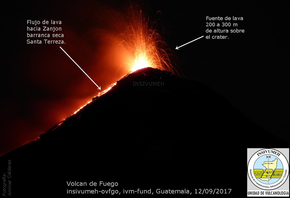 |
Figure 79. Incandescent lava rises 200-300 m above the summit of Fuego, and a lava flow traveled down the Santa Theresa ravine on the W flank during eruptive episode 9 on 12 September 2017. View from Panimaché I webcam. Courtesy of OVFGO-INSIVUMEH (Reporte Semanal de Monitoreo: Volcán de Fuego (1402-09), Semana del 09 al 15 de septiembre 2017. |
The Washington VAAC reported weak puffs of ash drifting N and quickly dissipating on 25 September, and another ash plume extending 15 km W on 28 September at 4.6 km. Hotspots were also observed both days in satellite images. INSIVUMEH reported eruptive episode 10 during 27-28 September, lasting about 40 hours. The ash plume generated during the episode drifted in multiple directions simultaneously (figure 80) and resulted in ashfall more than 30 km from the crater, primarily N and NE, in La Soledad (7 km N), Pastores (20 km NNE), San Miguel Dueñas (10 km NE) and Antigua Guatemala (20 km NE). The incandescent material reached 300 meters above the crater and fed two lava flows, the first went 300 m down the Seca Canyon, and the second traveled 500 m down Las Lajas Canyon.
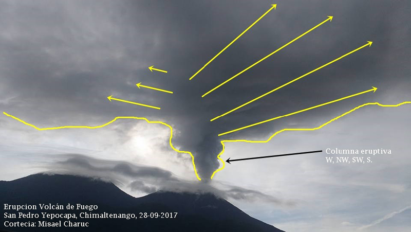 |
Figure 80. The ash plumes drift in multiple directions (W, NW, SW and S) from the summit of Fuego on 28 September 2017 during eruptive episode 10. Image taken in San Pedro Yepocapa, 8 km NW. Courtesy of INSIVUMEH (Reporte Semanal de Monitoreo: Volcán de Fuego (1402-09), Semana del 23 al 29 de septiembre 2017). |
Seven lahars were recorded during September in the main ravines of Fuego, on days 3, 4, 5, 6, 8, 27, and 29, as a result of the unusually large amount of rainfall during the month (1,059 mm) (figure 81). The larger ones at the beginning of the month contained blocks up to 3 m in diameter, and many were warm enough to generate steam with strong odors of SO2. Several roads were damaged.
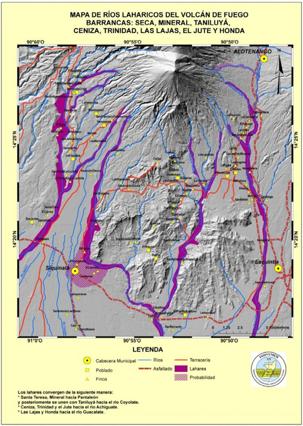 |
Figure 81. High rainfall (1,059 mm) during September 2017 generated large lahars in the Seca, Mineral, Taniluya, Ceniza, Trinidad, Las Lahas, El Jute, and Honda ravines at Fuego, shown in purple. Many dirt roads (shown in red) were damaged. Courtesy of INSIVUMEH (VOLCÁN DE FUEGO, INFORME MENSUAL, Septiembre 2017). |
Activity during October 2017. Overall activity was quieter during October 2017. Background levels of activity included incandescent material rising up to 250 m above the summit and falling a similar distance down the flanks, and ash plumes rising to 4.4-5.0 km altitude and drifting more than 25 km W, NW, and E. Eight to twelve explosions per hour were not uncommon, although 4-6 per hour were more typical. A few of the block avalanches traveled 2 km down the flanks. The communities that experienced persistent ashfall were all located 10-20 km SW, and included Morelia, Palo Verde Farm, Sangre de Cristo, El Porvenir, Santa Sofía, and Panimaché I and II. Due to the wind conditions and increased activity during the first week of October, ashfall was also reported farther away in Guatemala City (40 km NE), Antigua Guatemala, Villa Nueva (30 km ENE) and San Miguel Petapa (35 km ENE). INSIVUMEH reported three increases in explosive activity during the month on 2, 3, and 5 October, but they did not develop into eruptive episodes.
Four lahars were reported on 1, 2, and 4 October in the Seca and Mineral drainages. They carried blocks of volcanic rocks and debris as large as 3 m in diameter and were 6-12 m wide and 1-2 m deep. The Washington VAAC reported a series of explosions on 4 October, after which ash emissions were seen in multispectral imagery at 5.2 km altitude drifting SW that reached as far as 75 km. They reported occasional puffs of ash on 15 October extending up to 95 km W of the summit. By 17 October, imagery showed continuous emissions with an ash plume extending 95 km SSW from the summit before dissipating. A possible ash plume was reported by the Washington VAAC on 31 October extending 45 km W from the summit at 4.3 km altitude.
Activity during November 2017. There were numerous periods of intermittent ash emissions during November. Continuous emissions often drifted 65-100 km or more SW or W at altitudes around 4.6-5.2 km during periods of activity. INSIVUMEH reported that during 2-3 November tremor at Fuego increased. Explosions during the first week averaged 5-8 per hour and ash plumes rose as high as 1.3 km above the crater. Incandescent material was ejected 300 m above the crater, causing avalanches that were confined to the crater. The 11th eruptive episode in 2017 began on 5 November and lasted for two days. Lava flowed 1-1.2 km W down the Seca drainage and 800 m SSW down the Ceniza drainage. Avalanches of material from the ends of the lava flows descended the flanks and reached vegetated areas.
Ashfall was reported in areas downwind in the communities 8-12 km SW including Morelia, Santa Sofia, Palo Verde Farm, and Panimaché I and II throughout the month. Shockwaves from explosions often rattled windows and roofs around the volcano. Avalanche blocks were reported in the Cenizas, Trinidad, Taniluyá and Seca canyons. Multiple VAAC reports were issued on 25 days of November, and multiple daily MODVOLC thermal alerts were issued on 20 days of the month. On 10 November the emissions extended about 275 km WSW from the summit. A lahar during the third week descended the Seca and el Mineral drainages.
Activity during December 2017. Explosions averaged 4-8 per hour during most of December sending incandescent material 200-250 m above the crater. INSIVUMEH reported that the 12th eruptive episode at Fuego in 2017 began on 10 December and, based on seismicity, lasted for about 36 hours. Ash plumes from moderate-to-strong explosions rose as high as 1.2 km above the crater rim and drifted 20 km S and SW. Lava flowed as far as 1.5 km W down the Seca (Santa Teresa), SW down the Taniluyá, and SSW down the Ceniza ravines. Ash fell many times in the communities of La Rochela, San Andrés Osuna, Morelia, and Panimaché I and II. On 12 December there was an average of 10 explosions per hour, generating avalanches in the Ceniza and Taniluyá drainages and ashfall in nearby areas. Ashfall was also reported in San Miguel Dueñas, Alotenango, and Ciudad Vieja (13.5 km NE) on 14 December.
Multiple MODVOLC thermal alerts appeared on 20 days during December, and the Washington VAAC issued 91 reports of continuous or intermittent ash plume activity. During eruptive episode 12 on 11 December, they reported an intense hot spot seen at the crater in satellite imagery despite meteoric cloud cover. For most of the second half of December, either continuous or intermittent ash emissions drifted 100-150 km WNW from the summit before dissipating. The Washington VAAC reported an ash emission on 20 December drifting WNW at 5.8 km altitude that extended over 300 km from the summit. A remnant of the plume was observed almost 450 km away late on 20 December before dissipating. Plumes were repeatedly observed over 200 km from the summit during 20-25 December.
Geological Summary. Volcán Fuego, one of Central America's most active volcanoes, is also one of three large stratovolcanoes overlooking Guatemala's former capital, Antigua. The scarp of an older edifice, Meseta, lies between Fuego and Acatenango to the north. Construction of Meseta dates back to about 230,000 years and continued until the late Pleistocene or early Holocene. Collapse of Meseta may have produced the massive Escuintla debris-avalanche deposit, which extends about 50 km onto the Pacific coastal plain. Growth of the modern Fuego volcano followed, continuing the southward migration of volcanism that began at the mostly andesitic Acatenango. Eruptions at Fuego have become more mafic with time, and most historical activity has produced basaltic rocks. Frequent vigorous eruptions have been recorded since the onset of the Spanish era in 1524, and have produced major ashfalls, along with occasional pyroclastic flows and lava flows.
Information Contacts: Coordinadora Nacional para la Reducción de Desastres (CONRED), Av. Hincapié 21-72, Zona 13, Guatemala City, Guatemala (URL: http://conred.gob.gt/www/index.php ); Instituto Nacional de Sismologia, Vulcanologia, Meteorologia e Hydrologia (INSIVUMEH), Unit of Volcanology, Geologic Department of Investigation and Services, 7a Av. 14-57, Zona 13, Guatemala City, Guatemala (URL: http://www.insivumeh.gob.gt/ ); MIROVA (Middle InfraRed Observation of Volcanic Activity), a collaborative project between the Universities of Turin and Florence (Italy) supported by the Centre for Volcanic Risk of the Italian Civil Protection Department (URL: http://www.mirovaweb.it/); Hawai'i Institute of Geophysics and Planetology (HIGP), MODVOLC Thermal Alerts System, School of Ocean and Earth Science and Technology (SOEST), Univ. of Hawai'i, 2525 Correa Road, Honolulu, HI 96822, USA (URL: http://modis.higp.hawaii.edu/).