Report on Sangay (Ecuador) — March 2018

Bulletin of the Global Volcanism Network, vol. 43, no. 3 (March 2018)
Managing Editor: Edward Venzke.
Edited by A. Elizabeth Crafford.
Sangay (Ecuador) Eruptive episode of ash-bearing explosions and lava on SE flank, 20 July-26 October 2017
Please cite this report as:
Global Volcanism Program, 2018. Report on Sangay (Ecuador) (Crafford, A.E., and Venzke, E., eds.). Bulletin of the Global Volcanism Network, 43:3. Smithsonian Institution. https://doi.org/10.5479/si.GVP.BGVN201803-352090
Sangay
Ecuador
2.005°S, 78.341°W; summit elev. 5286 m
All times are local (unless otherwise noted)
Periodic eruptive activity at Ecuador's remote Sangay has included frequent explosions with ash emissions and occasional andesitic block lava flows. Eruptive activity from late March to mid-November 2016 included multiple ash emissions and persistent thermal signals through July 2016 (BGVN 42:08). A new episode of ash emissions and thermal anomalies, that began on 20 July 2017 (BGVN 42:08) and lasted through late October 2017, is covered in this report. Subsequent activity through February 2018 included a single ash-emission event near the end of the month. Information is provided by Ecuador's Instituto Geofísico (IG) and the Washington Volcanic Ash Advisory Center (VAAC); thermal data from the MODIS satellite instrument is recorded by the University of Hawaii's MODVOLC system and the Italian MIROVA project.
The first ash plume of the latest eruptive episode at Sangay was reported on 20 July 2017. VAAC reports were issued on 20 and 21 July, eleven days in August, six days in September, and on 13 October. Thermal activity first appeared in a MIROVA plot during the last week of July and continued through 26 October. Multiple MODVOLC thermal alerts were issued between 2 August and 19 October. IG reported that low-energy ash emissions rising 1 km or less above the summit crater were typical throughout the period. They also repeatedly noted two distinct thermal hot spots in satellite data. A single ash emission on 25 February 2018 was the only additional activity through the end of February 2018.
Activity during July-October 2017. The Washington VAAC reported an ash emission on 20 July 2017 that rose to 8.2 km altitude and drifted about 80 km W. A plume was reported on 1 August by the Guyaquil MWO near the summit at about 5.3 km altitude, but was obscured by clouds in satellite imagery. The following day an ash plume was observed at 7.6 km altitude centered about 15 km NW of the summit. An ash emission was reported on 6 August, but was not visible in satellite imagery. The MWO reported an ash emission on 12 August at 6.4 km altitude moving SW, but no ash was detected in satellite imagery under partly cloudy conditions. The Washington VAAC observed an ash plume on 13 August extending around 50 km SW at 6.1 km altitude and a well-defined hotpot. IG reported an ash emission drifting W on 16 August, but clouds obscured satellite views of the plume. Hotspots continued to be observed in shortwave infrared (SWIR) imagery. The Washington VAAC reported an ash plume at 8.2 km altitude on 17 August. The imagery showed an initial puff moving NW followed by several smaller puffs. On 19 August, the Guayaquil MWO reported an ash plume at 5.8 km altitude drifting SW. The next day, another explosion was reported with ash rising again to 5.8 km and drifting W, and a hotspot was observed in satellite imagery.
The Washington VAAC reported a possible ash plume extending 30 km SW of the summit at 7 km altitude on 22 August. It had dissipated the next day, but they noted that a hotspot was visible in SWIR imagery. The next ash plume was reported by the MWO on 1 September at 5.2 km altitude but was not observed in satellite imagery. The next day, the Washington VAAC observed an ash plume at 6.1 km altitude extending 15 km NW of the summit. The Guayaquil MWO reported an ash plume to 7.3 km altitude on 6 September. On 20 September, a possible ash plume could be seen in GOES-16 imagery extending about 150 km W from the summit at 6.1 km altitude. Another plume extended 15 km SW from the summit later in the day at the same altitude. By the end of the day, continuous ash emissions were reported drifting W at 5.8 km altitude. The following day, occasional ash emissions were still reported drifting W and dissipating within 35 km of the summit. A new emission late on 21 September sent an ash plume 25 km W of the summit at 6.1 km altitude. Possible ongoing emissions were reported on 22 September, but not visible in satellite imagery. After three weeks of quiet, the Washington VAAC reported an ash emission on 13 October drifting S at 6.1 km altitude along with a bright hot spot visible for part of the day. This was the last report of ash emissions for 2017.
The eruption that began on 20 July 2017 was characterized by explosions from the central crater and lava emissions from the Ñuñurco dome on the E side of the summit. IG reported two areas of hot spots visible in thermal images during August and September. Around 65 seismic explosions and 25 long-period events were recorded daily during most of this time, along with a few harmonic tremors. Low-energy ash emissions rising 1 km or less above the summit crater were typical. Ashfall was reported to the SW and NW in Culebrillas (75 km SW), and Licto (35 km NW). New lava flows were interpreted to be on the ESE flank by IG based on the repeated hot spots visible in satellite imagery and darkened areas in the snow in the webcam images (figure 23).
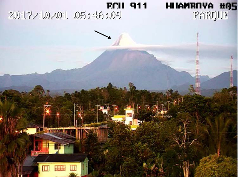 |
Figure 23. A dark streak in the snow near the summit (left side, arrow) of Sangay indicates recent ejecta of blocks or flows on the upper ESE flank of the cone on 1 October 2017. View is from the ECU911 webcam located in Huamboya, 40 km E. Courtesy of IG-EPN (Informe Especial del Volcán Sangay, 2017-2, Continúa la erupción, se observan dos ventos, 4 de octubre del 2017). |
Thermal activity measured from satellite instruments support the interpretation of significant lava emissions as blocks or flows at Sangay during late July-October 2017. The MODVOLC system reported 11 thermal alerts beginning on 14 August, 15 during September, and 13 between 3 and 19 October. A similar signal of thermal activity was recorded by the MIROVA system during the same period (figure 24).
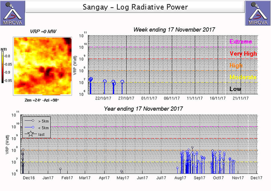 |
Figure 24. The MIROVA project graph of thermal anomalies in MODIS data from Sangay for the year ending on 17 November 2017 (lower graph) clearly shows the period of increased heat flow between late July and late October. The last anomaly appeared on 26 October 2017 (upper graph). Courtesy of MIROVA. |
Activity on 25 February 2018. The Washington VAAC reported an ash plume rising to 6.1 km altitude and drifting NE from the summit on 25 February 2018. The plume was visible 170 km NE before dissipating by the end of the day.
Geological Summary. The isolated Sangay volcano, located east of the Andean crest, is the southernmost of Ecuador's volcanoes and its most active. The steep-sided, glacier-covered, dominantly andesitic volcano grew within the open calderas of two previous edifices which were destroyed by collapse to the east, producing large debris avalanches that reached the Amazonian lowlands. The modern edifice dates back to at least 14,000 years ago. It towers above the tropical jungle on the east side; on the other sides flat plains of ash have been eroded by heavy rains into steep-walled canyons up to 600 m deep. The earliest report of an eruption was in 1628. Almost continuous eruptions were reported from 1728 until 1916, and again from 1934 to the present. The almost constant activity has caused frequent changes to the morphology of the summit crater complex.
Information Contacts: Instituto Geofísico (IG), Escuela Politécnica Nacional, Casilla 17-01-2759, Quito, Ecuador (URL: http://www.igepn.edu.ec ); Washington Volcanic Ash Advisory Center (VAAC), Satellite Analysis Branch (SAB), NOAA/NESDIS OSPO, NOAA Science Center Room 401, 5200 Auth Rd, Camp Springs, MD 20746, USA (URL: www.ospo.noaa.gov/Products/atmosphere/vaac, archive at: http://www.ssd.noaa.gov/VAAC/archive.html); Hawai'i Institute of Geophysics and Planetology (HIGP) - MODVOLC Thermal Alerts System, School of Ocean and Earth Science and Technology (SOEST), Univ. of Hawai'i, 2525 Correa Road, Honolulu, HI 96822, USA (URL: http://modis.higp.hawaii.edu/); MIROVA (Middle InfraRed Observation of Volcanic Activity), a collaborative project between the Universities of Turin and Florence (Italy) supported by the Centre for Volcanic Risk of the Italian Civil Protection Department (URL: http://www.mirovaweb.it/).