Report on Kadovar (Papua New Guinea) — April 2018
Bulletin of the Global Volcanism Network, vol. 43, no. 4 (April 2018)
Managing Editor: Edward Venzke.
Edited by A. Elizabeth Crafford.
Kadovar (Papua New Guinea) First confirmed historical eruption, ash plumes, and lava flow, January-March 2018
Please cite this report as:
Global Volcanism Program, 2018. Report on Kadovar (Papua New Guinea) (Crafford, A.E., and Venzke, E., eds.). Bulletin of the Global Volcanism Network, 43:4. Smithsonian Institution. https://doi.org/10.5479/si.GVP.BGVN201804-251002
Kadovar
Papua New Guinea
3.608°S, 144.588°E; summit elev. 365 m
All times are local (unless otherwise noted)
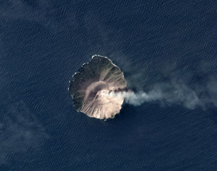
The first confirmed historical eruption at Kadovar began around mid-day local time on 5 January 2018, according to witnesses. The steeply-sloped island is approximately 1.4 km in diameter and is located about 25 km NNE from the mouth of the Sepik River on the mainland of Papua New Guinea (figure 1). This report covers activity from the beginning of the eruption on 5 January through March 2018. Information about the eruption is provided by the Rabaul Volcano Observatory (RVO), the Darwin Volcanic Ash Advisory Center (VAAC), satellite sources, news reports, and local observers. A possible eruption was witnessed by explorers in 1700; no other activity was reported until an outbreak of thermal activity in 1976 (NSEB 01:14-01:11, SEAN 03:09) and a short period of seismic unrest in 2015, according to RVO.
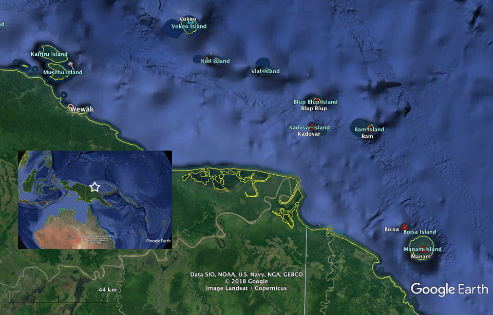 |
Figure 1. Kadovar Island is located about 25 km NNE from the mouth of the Sepik River on the mainland of Papua New Guinea. Nearby active volcanoes include Blup Blup (12 km N) and Bam (21 km W); residents of Kadovar were evacuated initially to Blup Blup before being moved to an area near Wewak, the nearest community on the mainland, about 105 km W. The red triangles are Holocene volcanoes, and the blue (cyan) triangles are Pleistocene volcanoes. Base map courtesy of Google Earth. |
Ash and steam emissions from Kadovar were first reported on 5 January 2018. After about 24 hours, more than half of the island was covered by volcanic debris. Activity intensified over the next two weeks; RVO identified five distinct vents located at the summit and along the SE coast. Dense ash plumes and steam rose from the summit vents, and a slowly-extruding lava flow emerged from a vent near the shoreline on the SE flank. Persistent steam and intermittent ash plumes were produced from the summit vent through the end of March. The lava flow grew outward from the shore for tens of meters before collapsing in early February, but it reappeared a few days later. By the end of the first week of March 2018 the flow was about 17 m above sea level; its growth rate had slowed, adding only one meter by late March.
The NOAA/CIMSS Volcanic Cloud Monitoring system generated an alert for an ash cloud moving WNW, as imaged by S-NPP VIIRS, at 0330 UTC on 5 January 2018; Himawari-8 imagery subsequently showed that the eruption began around 0220 UTC. The Darwin VAAC reported two discrete ash plumes drifting W at 2.1 km altitude during the day. After local reports of the eruption Samaritan Airlines flew administrators from the Wewak district to investigate, enabling photographs of ash and steam emissions (figure 2).
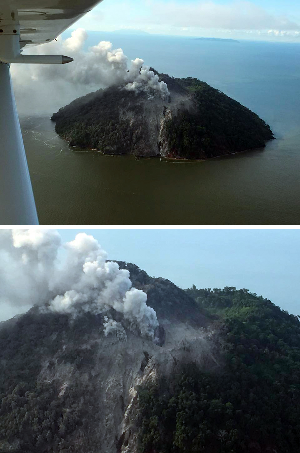 |
Figure 2. Steam and ash emerged from a vent near the summit of Kadovar Island and drifted WNW on 5 January 2018. The view is looking NW with the SE flank of Kadovar in the foreground. In the upper photo, the island in the background is Viai Island about 30 km NW. Photo by Ricky Wobar, administrator of the Wewak district. Courtesy of Samaritan Aviation, posted on Facebook on 5 January 2018. |
The following day, 6 January 2018, photos from a Samaritan Air flight showed that dark gray ash and steam plumes rising from a crater on the SE side of the summit had intensified (figures 3 and 4). It was estimated that 50 or 60% of the island was covered in volcanic debris, which appeared to be primarily ash along with some pyroclastic flows. According to the International Federation of Red Cross and Red Crescent Societies (IFRC), the entire population of Kadovar, about 600 people who lived on the N side of the island, was relocated to nearby Blup Blup Island which is home to about 800 residents. RVO reported minor ashfall on Kairiru and Mushu islands (115 km WNW), and on mainland Papua New Guinea at Mt. Uru in Yangoru (130 km W), Woginara (140 km W), and the Wewak District (100 km W).
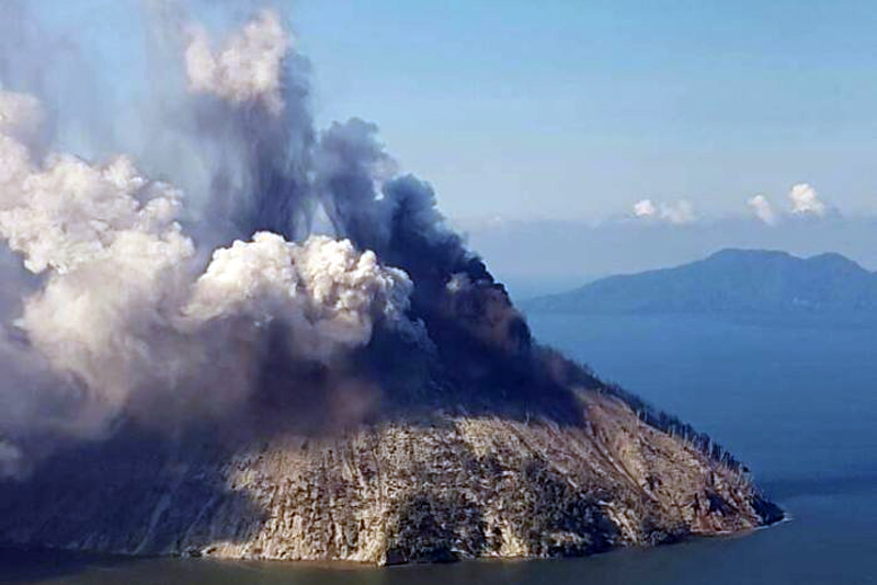 |
Figure 3. Ash and steam plumes rose from distinct vents on the SE side of the summit at Kadovar. View is to the NE, with Blup Blup volcano located about 12 km in the distance. Photo by Ricky Wobar likely taken on 6 January 2018, published by ABC News on 8 January 2018. Courtesy of ABC News. |
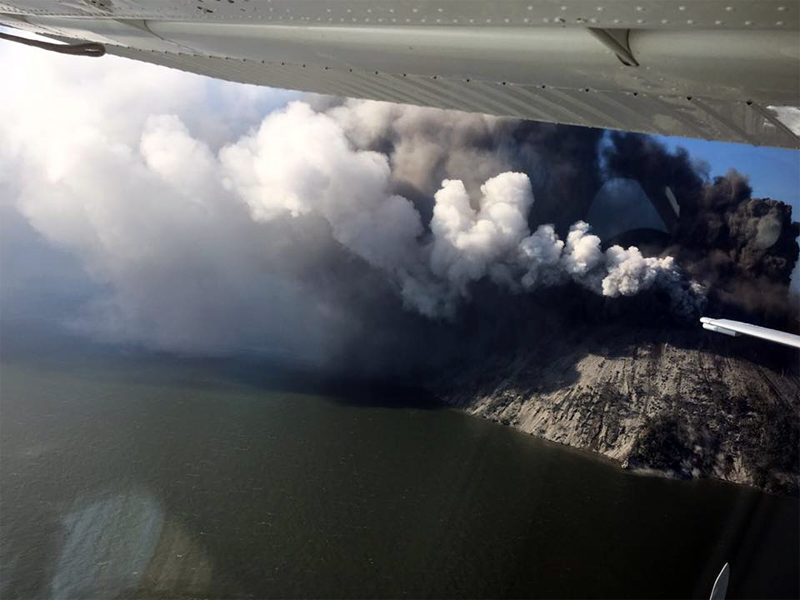 |
Figure 4. Ash and steam emissions intensified from vents at the summit of Kadovar Island on 6 January 2018. Posted on Facebook, 6 January 2018 by Samaritan Aviation. |
Also on 6 January 2018, missionary Brandon Buser set out from Wewak to visit Bam by boat. He observed the steam and ash plumes of Kadovar from about 75 km away. About 25 km W of the island, he felt falling ash. From a few hundred meters offshore he witnessed the ash and steam plumes rising from near the summit as he circled the S and E sides of the island (figures 5-8).
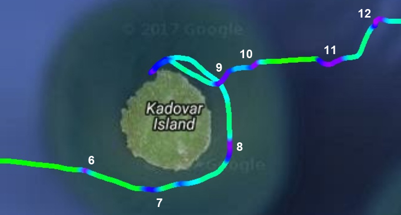 |
Figure 5. Locations of the following photographs of the eruption at Kadovar on 6 January 2018 correspond closely to the purple spots where the boat slowed down on its trip around the island. North is to the top. Numbers indicate approximate locations of the following figures 6-12. Courtesy of Brandon Buser. Base map courtesy of Google Earth. |
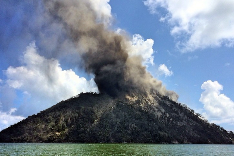 |
Figure 6. An ash plume drifted NW from the summit of Kadovar as viewed from a boat a few hundred meters off the SW flank on 6 January 2018. Courtesy of Brandon Buser. |
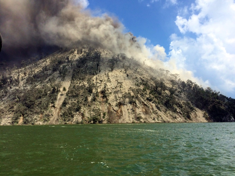 |
Figure 7. Ash drifted WNW from Kadovar and also covered the vegetation on the SSW flank on 6 January 2018 in this view from a boat a few hundred meters off the SSW flank. Courtesy of Brandon Buser. |
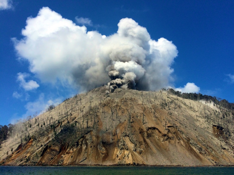 |
Figure 8. Dark ash and white steam both rose from vents at the summit of Kadovar on 6 January 2018. Debris and ashfall killed and denuded the trees on the SE flank, and covered the ground. View is from a boat a few hundred meters off the SE flank. Courtesy of Brandon Buser. |
While preparing to head E to Bam, Buser witnessed an explosion that sent large plumes of ash and steam skyward from the SE flank, and a significant cloud of volcanic debris was ejected outward and down the SE flank; large boulders fell into the ocean. Heading rapidly E away from the eruption, he took additional photographs (figures 9-12).
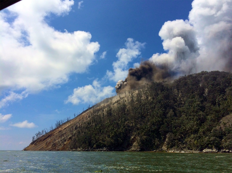 |
Figure 9. Dark gray ash and white steam billowed up from a vent near the summit of Kadovar on 6 January 2018 at the start of an explosion. The denuded vegetation and bare slopes on the SE flank indicated the extent of the recent activity. The view is from a boat a few hundred meters offshore of the NE flank. Courtesy of Brandon Buser. |
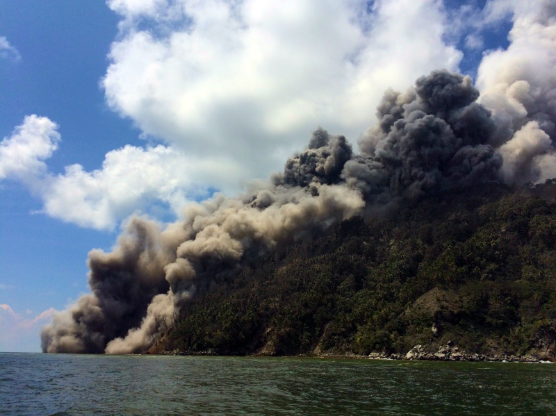 |
Figure 10. An explosion witnessed at Kadovar on 6 January 2018. Steam rose from a vent near the summit (right), dark gray ash billowed up from the SE flank, and brown dust and debris descended the SE flank into the ocean (left) in this view from a few hundred meters off the NE flank. Courtesy of Brandon Buser. |
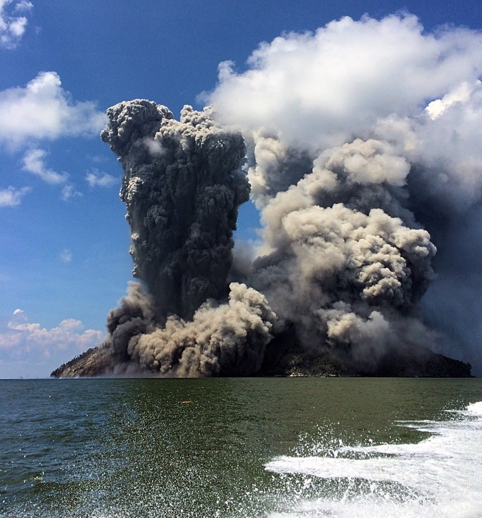 |
Figure 11. A large explosion at Kadovar witnessed on 6 January 2018. Light gray steam and ash rose from near the summit and drifted NW covering the N half of the island in ash; a large eruption of dark gray ash shot upward from a different vent on the SE flank surrounded by dust and debris that traveled outward at its base. Larger debris caused splashing in the water off the SE flank (left). View is from a few kilometers off the NE flank. Courtesy of Brandon Buser. |
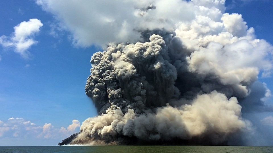 |
Figure 12. The plumes of steam, ash, and debris from the explosion moments earlier at Kadovar on 6 January 2018 rose and began to drift NW covering the island. Blocks landing in the ocean on the SE flank created spray along the shoreline (left). View is from a boat a few kilometers NE of the island. Courtesy of Brandon Buser. |
The Darwin VAAC reported on 6 January 2018 that a continuous ash plume was identifiable in satellite imagery moving W and WNW at 2.1 km altitude. By 7 January, the plume could be identified about 220 km WNW in satellite images (figure 13). During their return trip from Bam on 8 January 2018, the missionaries again circled the island and noted that the eruption seemed to be occurring from different vents. The island was covered in ash, and they became covered with wet ash as they traveled under the drifting ash plume. The Darwin VAAC reported the plume drifting WNW extending about 185 km on 8 January. They also noted that the influence of the sea breeze was also spreading minor ash to the SW. Continuous ash emissions were observed by the Darwin VAAC through 11 January, drifting W and NW at 2.1 km altitude.
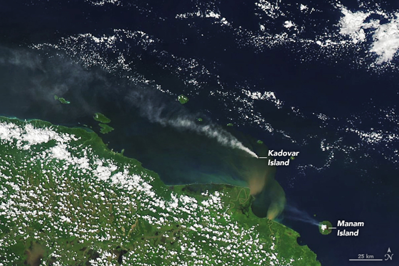 |
Figure 13. The Moderate Resolution Imaging Spectroradiometer (MODIS) on NASA's Aqua satellite captured the eruption of Kadovar that began two days earlier on 7 January 2018 as a plume of ash and steam that streamed NW from its crater. A second smaller plume, also drifting NW, is visible SE of Kadovar from unrelated activity at nearby Manam, one of Papua New Guinea's most active volcanos. Brown-green plumes visible in the water S of Kadovar near the coast of the mainland, are caused by sediment from the Sepik and Ramu rivers on the mainland. Courtesy of NASA Earth Observatory. |
RVO reported a significant escalation in activity during 12-13 January 2018. An explosion during the previous night ejected large incandescent boulders from the fracture on the SE flank. Residents on Blup Blup (15 km N) could see incandescence high on the volcano's flank. During a flyover on 13 January, RVO noted variable steam and gas emissions rising to 1 km above the Main Crater and identified five distinct vents (figure 14). The SE Coastal Vent was very active with dense white steam emissions rising 600 m from the vent (figure 15). A dome of lava was visible at the base of the steam plume, but no incandescence was observed. The Southern Coastal Vent had been vigorously steaming a few days earlier, and RVO interpreted it to be the source of the incandescent blocks in the explosion a few days before.
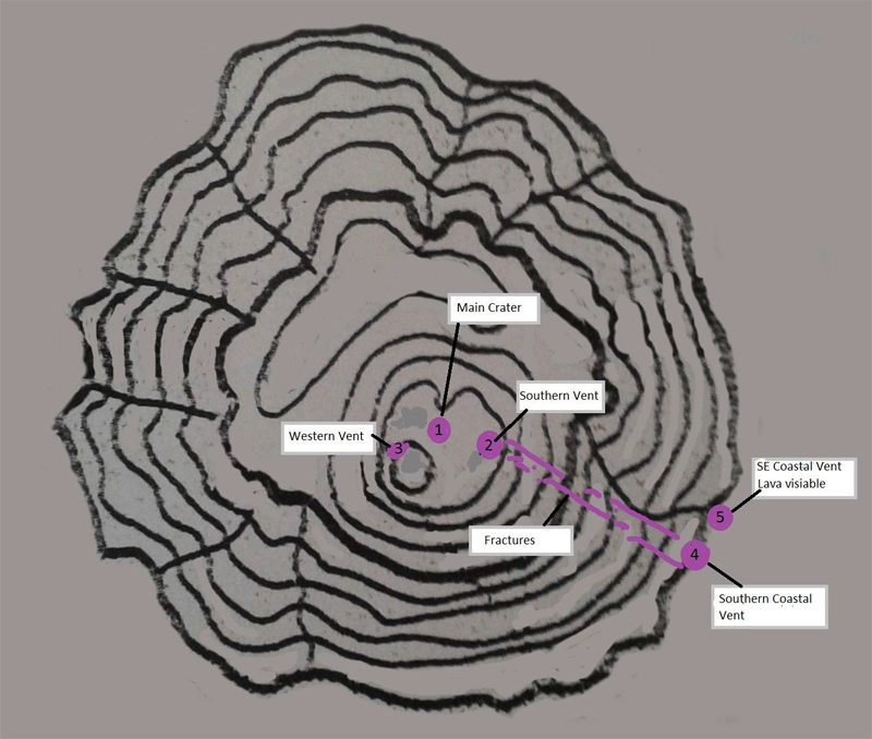 |
Figure 14. A sketch map of the five newly identified vents at Kadovar, 14 January 2018, from an RVO overflight the previous day. Courtesy of RVO (VOLCANO INFORMATION BULLETIN- No. 08 14/01/2018). |
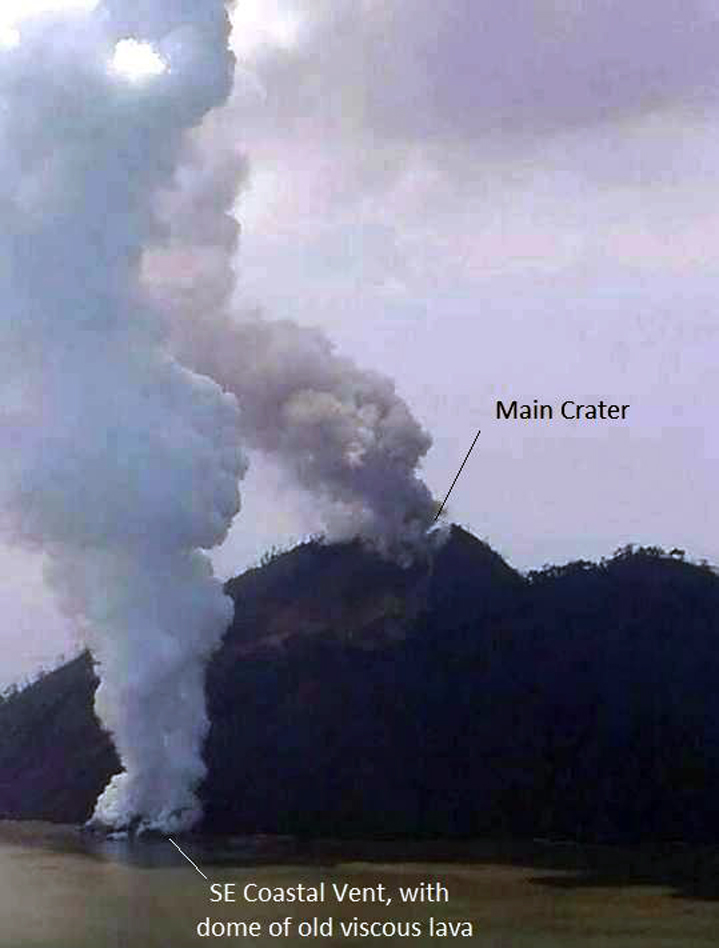 |
Figure 15. A vigorous steam plume rose from the SE Coastal Vent at Kadovar on 13 January 2018 while an ash plume rose from Main Crater at the summit. Photo by the office of Allan Bird, Governor of East Sepik Province. Courtesy of RVO (VOLCANO INFORMATION BULLETIN- No. 08 14/01/2018). |
Reports of continuous ash emissions at 2.1 km altitude drifting WNW from the Darwin VAAC resumed on 16 January. A brief emission to 3.7 km was also noted that day. Pilot reports on 17 and 18 January indicated that ash was still in the area as high as 3-3.7 km altitude drifting W. The reports of emissions from the Darwin VAAC continued through 24 January. Ash emissions were generally continuous at altitudes from 2.4 to 3 km, although low level emissions of primarily steam and gas were observed on 20 January that included intermittent phases of increased ash content. The plume drift direction was variable, with periods when ash drifted S and SE in addition to the generally prevailing NW and W directions.
During 18-22 January 2018, the Main Crater continued to produce moderate to dark gray ash plumes that rose 500-800 m above the summit, drifting locally S and SE, and a continuous steam plume from the SE Coastal Vent rose as high as 800 m above the island. An incandescent lava flow slowly extruded from the SE Coastal Vent. By the last week of January, the ash plumes were only rising about 100 m above the Main Crater and drifting W; weak incandescence was still observed at night. The white steam plume from the SE Coastal Vent rose closer to 400 m above the island. RVO estimated that the lava flow had risen to about 50 m above sea level and extended 150-200 m out from the coast.
In their report on 2 February 2018, RVO noted that the lava flow continued to grow. A distinct lobe had pushed out from the seaward nose of the flow, by about 20-30 m; it appeared to be channeled by levees which had developed at the flow's sides. At 1830 local time on 1 February, a collapse of the side of the flow facing Blup Blup was observed; it resulted in a plume of gray ash and then vigorous steaming at the collapse site, which also was incandescent at night. The main body of the flow significantly bulged upwards, with a distinct 'valley' visible between the bulge and the island's flank.
RVO reported that on 9 February the lava flow at the SE Coastal Vent had collapsed, causing 5-6 minor tsunamis less than 1 m high that were observed by residents on Blup Blup's E and W coasts. The waves were reported at 1050, before the main collapse of the dome. In a 12 February report, RVO noted that activity from Main Crater consisted of white plumes rising 20 m and drifting a few kilometers SE accompanied by weak nighttime crater incandescence. Activity renewed at the SE Coastal Vent shortly after the collapse of the flow on 9 February 2018; lava re-emerged a few days later, connecting a lava island to the coastline again. Continuous steam emissions from both the Main Crater and the SE Coastal Vent were interrupted by dark ash plumes on 16 and 20-22 February, and occasional explosions were heard by residents on nearby islands. Minor ashfall was reported on Blup Blup on 21 and 22 February.
Eruptive activity continued during March 2018, although at a slower rate. The Main Crater generally produced continuous emissions of white steam and intermittent explosions with dark ash plumes; incandescence was usually visible at night from Blup Blup. According to the Darwin VAAC, a pilot reported an ash plume at 3.9 km altitude drifting SE on 2 March; it was not visible in satellite imagery due to meteoric clouds. The lava flow extruding from the SE Coastal Vent continued to grow, creating a dome that grew from 7-8 m above sea level to 10-17 m above sea level by 8 March. Dark ash emissions from the vent and nighttime incandescence were common. The growth rate slowed later in the month, and only one meter of change was observed between 10 and 20 March.
Satellite data. The MIROVA project recorded thermal anomalies from Kadovar in early January and early March 2018 (figure 16). MODVOLC thermal alerts were issued on three days; 15 and 22 January, and 7 February 2018. During January, small SO2 plumes were recorded by NASA satellites on four occasions (figure 17).
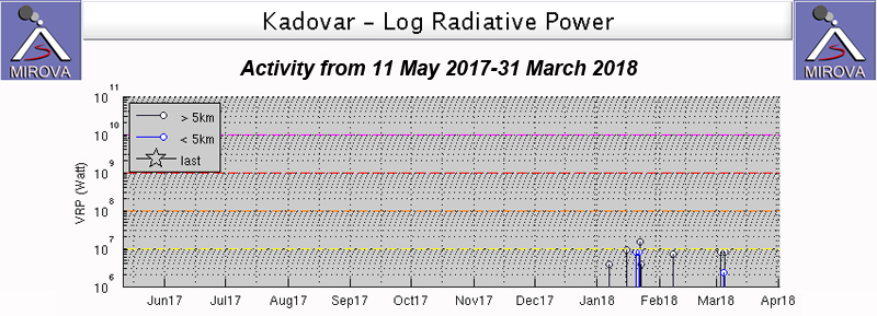 |
Figure 16. The MIROVA project thermal anomaly graph for Kadovar from 11 May 2017 through March 2018. The first anomaly in early January 2018 correlates with observations of the first reported explosion. Courtesy of MIROVA. |
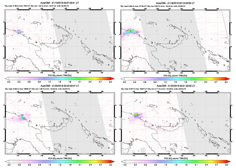 |
Figure 17. SO2 plumes from Kadovar were detected several times during January 2018 by the OMI instrument on NASA's Aura satellite. Courtesy of NASA Goddard Space Flight Center. |
Geological Summary. The 2-km-wide island of Kadovar is the emergent summit of a Bismarck Sea stratovolcano of Holocene age. It is part of the Schouten Islands, and lies off the coast of New Guinea, about 25 km N of the mouth of the Sepik River. Prior to an eruption that began in 2018, a lava dome formed the high point of the andesitic volcano, filling an arcuate landslide scarp open to the south; submarine debris-avalanche deposits occur in that direction. Thick lava flows with columnar jointing forms low cliffs along the coast. The youthful island lacks fringing or offshore reefs. A period of heightened thermal phenomena took place in 1976. An eruption began in January 2018 that included lava effusion from vents at the summit and at the E coast.
Information Contacts: Rabaul Volcano Observatory (RVO), Geohazards Management Division, Department of Mineral Policy and Geohazards Management (DMPGM), PO Box 3386, Kokopo, East New Britain Province, Papua New Guinea, Contact: steve_saunders@mineral.gov.pg, ima_itikarai@mineral.gov.pg; Darwin Volcanic Ash Advisory Centre (VAAC), Bureau of Meteorology, Northern Territory Regional Office, PO Box 40050, Casuarina, NT 0811, Australia (URL: http://www.bom.gov.au/info/vaac/); NASA Earth Observatory, EOS Project Science Office, NASA Goddard Space Flight Center, Goddard, Maryland, USA (URL: http://earthobservatory.nasa.gov/); NASA Goddard Space Flight Center (NASA/GSFC), Global Sulfur Dioxide Monitoring Page, Atmospheric Chemistry and Dynamics Laboratory, 8800 Greenbelt Road, Goddard, Maryland, USA (URL: https://so2.gsfc.nasa.gov/); NOAA, Cooperative Institute for Meteorological Satellite Studies (CIMSS), Space Science and Engineering Center (SSEC), University of Wisconsin-Madison, 1225 W. Dayton St., Madison, Wisconsin 53706, USA (URL: http://cimss.ssec.wisc.edu/); International Federation of Red Cross and Red Crescent Societies (IFRC) (URL: http://www.ifrc.org/); Samaritan Aviation (URL: http://samaviation.com/, https://www.facebook.com/samaritanaviation/); Brandon Buser (URL: https://ethnos360.org/missionaries/brandon-and-rachel-buser, https://www.facebook.com/brandon.buser.35); ABC News (URL: http://www.abc.net.au/news/2018-01-08/tsunami-warning-for-communities-near-erupting-png-volcano/9311544); Google Earth (URL: https://www.google.com/earth/).