Report on Karangetang (Indonesia) — May 2018

Bulletin of the Global Volcanism Network, vol. 43, no. 5 (May 2018)
Managing Editor: Edward Venzke.
Research and preparation by Paul Berger.
Karangetang (Indonesia) Small ash plume and incandescence seen on 2 February 2018
Please cite this report as:
Global Volcanism Program, 2018. Report on Karangetang (Indonesia) (Venzke, E., ed.). Bulletin of the Global Volcanism Network, 43:5. Smithsonian Institution. https://doi.org/10.5479/si.GVP.BGVN201805-267020
Karangetang
Indonesia
2.781°N, 125.407°E; summit elev. 1797 m
All times are local (unless otherwise noted)
Eruptive activity at Karangetang between June 2014 and March 2016 included intermittent ash plumes, lava flows, pyroclastic flows, and persistent thermal anomalies from a slowly growing lava dome (BGVN 42:02) south of the highest summit (figure 16). Activity since mid-March 2016 has been low, with only a few notable events consisting of a possible ash plume on 10 May 2017, a strong sulfur dioxide emission on 10 October 2017, and a small ash explosion on 2 February 2018. Information was mainly provided by the Pusat Vulkanologi dan Mitigasi Bencana Geologi (PVMBG, also known as Indonesian Center for Volcanology and Geological Hazard Mitigation, CVGHM), the Darwin Volcanic Ash Advisory Centre (VAAC).
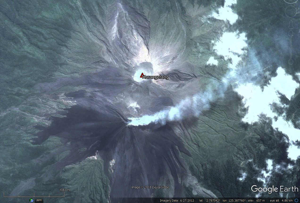 |
Figure 16. Satellite image of the summit area of Karangetang on 27 June 2012. The active dome is steaming, with the fumarolic plume curving towards the NE. Dark-colored recent lava flows are noticeable. The higher inactive summit is about 500 m N and 20 m higher than the active dome. Courtesy of DigitalGlobe and Google Earth. |
Based on analyses of satellite imagery, wind data, and ground-based visual observations, the Darwin VAAC reported that on 10 May 2017 a gas-and-steam plume apparently containing ash rose to an altitude of 3.6 km and drifted over 35 km SE. The Aviation Color Code was briefly raised to Orange.
According to a news account (Antara News) that quoted the chief of the volcano's observatory post, "sulfuric smoke" rose 200 m on 10 October 2017. The official stated that this was natural activity for the volcano and also indicated that several types of tremor had occurred the previous day. A small SO2 anomaly near the volcano was detected on 11 October 2017, registering 2.1 Dobson Units on the Aura satellite Ozone Monitoring Instrument.
In a Volcano Observatory Notice for Aviation (VONA) issued on 2 February 2018, PVMBG reported an explosion, crater incandescence, and an ash plume that rose 600 m above the summit. The Aviation Color Code was raised from Unassigned to Yellow.
No MODVOLC thermal anomalies were detected during the reporting period. The MIROVA system, however, detected twelve scattered low-power thermal anomalies in the year ending on 26 April 2018. One of the thermal anomalies occurred around 10 October.
Geological Summary. Karangetang (Api Siau) volcano lies at the northern end of the island of Siau, about 125 km NNE of the NE-most point of Sulawesi. The stratovolcano contains five summit craters along a N-S line. It is one of Indonesia's most active volcanoes, with more than 40 eruptions recorded since 1675 and many additional small eruptions that were not documented (Neumann van Padang, 1951). Twentieth-century eruptions have included frequent explosive activity sometimes accompanied by pyroclastic flows and lahars. Lava dome growth has occurred in the summit craters; collapse of lava flow fronts have produced pyroclastic flows.
Information Contacts: Pusat Vulkanologi dan Mitigasi Bencana Geologi (PVMBG, also known as Indonesian Center for Volcanology and Geological Hazard Mitigation, CVGHM), Jalan Diponegoro 57, Bandung 40122, Indonesia (URL: http://www.vsi.esdm.go.id/); Darwin Volcanic Ash Advisory Centre (VAAC), Bureau of Meteorology, Northern Territory Regional Office, PO Box 40050, Casuarina, NT 0811, Australia (URL: http://www.bom.gov.au/info/vaac/); Hawai'i Institute of Geophysics and Planetology (HIGP) - MODVOLC Thermal Alerts System, School of Ocean and Earth Science and Technology (SOEST), Univ. of Hawai'i, 2525 Correa Road, Honolulu, HI 96822, USA (URL: http://modis.higp.hawaii.edu/); MIROVA (Middle InfraRed Observation of Volcanic Activity), a collaborative project between the Universities of Turin and Florence (Italy) supported by the Centre for Volcanic Risk of the Italian Civil Protection Department (URL: http://www.mirovaweb.it/); NASA Goddard Space Flight Center (NASA/GSFC), Global Sulfur Dioxide Monitoring Page, Atmospheric Chemistry and Dynamics Laboratory, 8800 Greenbelt Road, Goddard, Maryland, USA (URL: https://so2.gsfc.nasa.gov/); Antara News (URL: https://en.antaranews.com/).