Report on Kirishimayama (Japan) — June 2018

Bulletin of the Global Volcanism Network, vol. 43, no. 6 (June 2018)
Managing Editor: Edward Venzke.
Edited by A. Elizabeth Crafford.
Kirishimayama (Japan) Ash plumes and lava flows at Shinmoedake starting in March 2018; explosion at Iwo-yama
Please cite this report as:
Global Volcanism Program, 2018. Report on Kirishimayama (Japan) (Crafford, A.E., and Venzke, E., eds.). Bulletin of the Global Volcanism Network, 43:6. Smithsonian Institution. https://doi.org/10.5479/si.GVP.BGVN201806-282090
Kirishimayama
Japan
31.934°N, 130.862°E; summit elev. 1700 m
All times are local (unless otherwise noted)
Kirishimayama is a large group of more than 20 Quaternary volcanoes located N of Kagoshima Bay, Japan (figure 22). For the last 1,000 years, repeated eruptions have taken place at two locations in the complex: the Ohachi crater on the W flank of the Takachihomine stratovolcano, and the Shinmoedake stratovolcano 4 km NW of Ohachi. A single eruption was reported in 1768 from the Iwo-yama (Ebino Kogen) dome located on the NW flank of the Karakunidake stratovolcano, about 5 km NW of Shinmoedake.
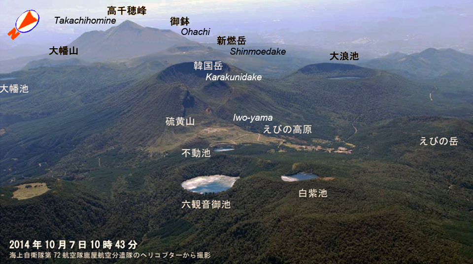 |
Figure 22. Subfeatures of the Kirishimayama volcanic complex showing the three areas with activity discussed in this report: Ohachi, Shinmoedake, and Iwo-yama (Ebino Kogen). View is to the SE. Image taken by the Japan Maritime Self Defense Force on 7 October 2014. Courtesy of JMA (Volcanic activity report on Kirishimayama, October, Heisei 26 (2014)). |
The last confirmed eruption at the Ohachi crater was in July 1923. Intermittent steam plumes have been observed since then, including in December 2003 (BGVN 33:09), but the Japan Meteorological Agency (JMA) noted that it had been quiet since 1 December 2007. Shinmoedake has been the site of several short-lived eruptive events since 2008. Most of the events were single-day explosions with ash emissions (BGVN 35:12). A more protracted event from January to September 2011 included numerous explosions with ash plumes, which produced ashfall tens of kilometers away, the growth of a lava dome, ejecta of large blocks, and small pyroclastic flows (BGVN 36:07). Shinmoedake remained quiet until seismicity increased on 23 September 2017, followed by several explosions during October 2017 (BGVN 43:01). Seismic unrest was first reported from the area around Iwo-yama in December 2013, and it has been regularly monitored since that time. This report covers activity from November 2017 through May 2018 and includes new explosive events at Shinmoedake during March-May 2018, an explosive event at Iwo-yama in April 2018, and a brief increase in seismicity at Ohachi in February 2018. Information is provided primarily by the JMA and the Tokyo Volcanic Ash Advisory Center (VAAC), with additional satellite data and news media reports.
Summary of activity during November 2017-May 2018. After steam plumes disappeared at Ohachi in mid-2006, only minor intermittent seismicity was reported through 2017. A sudden increase in earthquakes and tremor activity on 9 February 2018 led JMA to raise the 5-level Alert Level system from 1 (potential for increased activity) to 2 (do not approach the crater) for about a month. Activity diminished after the middle of February and Ohachi remained quiet through May 2018, with only a continuing modest thermal anomaly at the crater.
The latest eruptive episode at Shinmoedake, during 11-17 October 2017, generated an SO2 plume recorded by NASA satellites, caused ashfall up to 100 km away, and created a new vent about 80 m in diameter on the E side of the crater. Intermittent earthquakes and tremors along with low-level steam plumes characterized activity during November 2017-February 2018. A new eruptive episode began on 1 March 2018 with near-constant explosive activity that lasted until 10 March. A new lava flow at the summit was first observed by JMA on 6 March and began to overflow the NW rim of the crater on 9 March. The Tokyo VAAC reported ash plumes over 6 km altitude on 10 March. An explosion on 5 April produced the largest ash plume of the period; it rose to 10.1 km altitude, was visible drifting E for 24 hours, and resulted in significant ashfall in the region. The lava flow had ceased advancing down the NW flank by the end of April. Another explosion on 14 May 2018 generated an ash plume that rose to 7.3 km altitude and caused ashfall 30 km S that covered the roadways.
An increase in seismicity at Iwo-yama in December 2013, followed by a 7-minute-period of tremor activity in August 2014 was the first recorded at the site since 1768. Thermal anomalies and weak fumarolic activity first appeared in December 2015. Seismicity, including intermittent tremor events and larger amplitude earthquakes, gradually increased during 2016 and 2017. Intermittent fumarolic activity and temperature anomalies began to increase measurably in mid-2017. Jets of sediment-laden hot water emerged from several vents early in 2017. A further increase in fumarolic activity and the temperature of the thermal anomalies in February 2018 led JMA to raise the Alert Level at Iwo-yama. Large amplitude earthquakes and a tremor event accompanied an ash-bearing explosion on 19 April 2018 from a vent on the S side of Iwo-yama. The following day, a vent opened 500 m to the W and produced vigorous steam emissions. On 26 April 2018 an explosion from the new vent sent ash 200 m high. Jets of hot water continued at the Iwo-yama vents through May 2018.
Activity at Ohachi during 2003-May 2018. JMA reported tremor activity with epicenters near Ohachi in mid-December 2003 (BGVN 33:09) that was followed by fumarolic activity for a few weeks. Intermittent steam plumes were observed during 2004; on 26 March 2004 a tremor event lasted for four hours and a steam plume rose 800 m above the crater (figure 23). A few periods of microtremor were recorded, and intermittent fumarolic activity was observed with webcams until March 2006, after which most activity ceased. JMA lowered the 5-level Alert Level from 2 (Do not approach the crater) to 1 (Potential for increased activity) on 22 May 2006. Fumarolic activity was not observed after July 2006, and no new thermal activity was reported during a field visit in October 2006. Minor seismicity was reported for a few days during July 2007, and small-amplitude, short-duration tremor activity was occasionally recorded during 2008-2014.
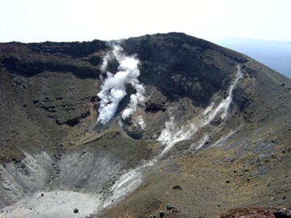 |
Figure 23. Steam plumes were visible on the NW side of the Ohachi crater at Kirishimayama on 31 March 2004. Courtesy of JMA (JMA Kirishimayama annual report, Heisei 16 (2004)). |
Although earthquake activity increased slightly in July 2015, the warning level was not raised, and no surface fumarolic activity was observed during field visits in August and September 2015 (figure 24). Seismic activity remained elevated at Ohachi through February 2016 and then gradually decreased during March. Although tremors were recorded in May and December 2016, there was no change in condition at the site and seismicity continued to decrease; no tremors were recorded during 2017.
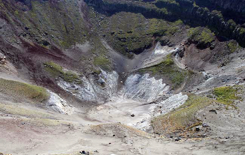 |
Figure 24. No fumarolic activity was visible at the Ohachi crater at Kirishimayama on 18 September 2015 during a site visit. View is to the NW. Courtesy of JMA (JMA Kirishimayama annual report, Heisei 27 (2015)). |
Earthquake frequency on the SW side of Ohachi increased during 9-16 February 2018, resulting in 199 seismic events, and tremor activity was also recorded on 9 February. This activity led JMA to increase the Alert Level to 2 on 9 February 2018. In spite of the increased seismic activity, the thermal activity remained unchanged from previous months with continued minor thermal anomalies in the same areas as before (figure 25). Seismicity decreased significantly during March 2018 to only 13 volcanic earthquakes, and no microtremor activity was recorded. Inspections carried out on 11 and 14 March showed no surface changes (figure 26) and resulted in JMA lowering the Alert Level back to 1 on 15 March 2018. Ohachi remained quiet through May 2018.
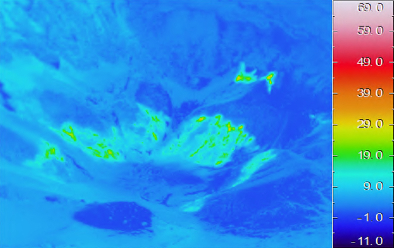 |
Figure 25. Thermal anomalies at the Ohachi crater of Kirishimayama were unchanged compared with previous months when measured on 9 February 2018 in this view to the NW. Courtesy of JMA (Volcanic activity commentary on Kirishimayama, February, Heisei 30 (2018)). |
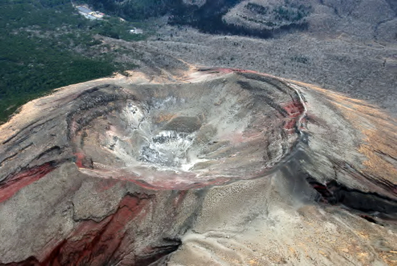 |
Figure 26. An overview looking W of the Ohachi crater at Kirishimayama on 2 March 2018 showed no surface activity after the increased seismicity of February. Courtesy of JMA (Volcanic activity commentary on Kirishimayama, March, Heisei 30 (2018)). |
Activity at Shinmoedake during August 2008-October 2017. An explosion on 22 August 2008 lasted for about six hours and produced ashfall in Kobayashi City (10 km NE) (BGVN 33:09). Seismicity had increased rapidly a few days prior to the explosion, and then decreased gradually for the remainder of 2008. Other than a brief increase in seismicity in May the following year, only steam plumes rising about 100 m from the crater were reported for 2009.
Seven small ash-bearing explosive events were reported during March-July 2010. Small-amplitude tremor activity on 30 March 2010 was accompanied by a plume that rose 400 m above the crater rim; a small amount of ash fell 400 m to the W of the fumarole within the crater. The webcam on the S rim of the crater captured a grayish plume rising 300 m after a small explosion on 17 April 2010. Another small explosion on 27 May produced a grayish-white plume that rose 100 m above the crater rim and resulted in minor ashfall NE in Kobayashi City. Officials noted a new fumarole on the W flank after this event. Two more explosions on 27 and 28 June 2010 resulted in a small amount of ash deposited 10 km E of Shinmoedake. A small explosion was reported on 5 July. On 10 July, a grayish-white plume, observed in the webcam, rose 100 m above the crater rim after an explosion, and a small low-temperature pyroclastic surge flowed 300 m down the SW slope. GPS instruments recorded minor inflation from December 2009 through September 2010.
A new, more substantial, eruption began at Shinmoedake on 19 January 2011. Activity increased on 26 January with an explosion that released a large volume of ash and pumice and included the growth of a new lava dome (BGVN 35:12, 36:07). Thirteen additional explosions occurred through 1 March 2011. Activity became more intermittent after mid-February, and the last emission was reported on 7 September 2011. Seismicity declined significantly in March 2012 and had returned to background levels by May 2012. With no surface changes and very low seismicity, JMA reduced the Alert Level from 3 to 2 on 22 October 2013, and the only reported activity was steam plumes rising 50-200 m above the crater rim during 2013. The lava dome in the crater remained about 600 m in diameter. Inflation had slowed and stopped after December 2011 but began again around December 2013. Shallow, low-level seismicity during 2014 with epicenters near Shinmoedake was distributed within a few kilometers below the summit; there were no surface changes observed at the crater during several overflights conducted by the Japan Maritime Self Defense Force throughout the year.
Occasional steam plumes rising 400 m above the crater rim were reported during 2015. Volcanic earthquakes were intermittent, with brief increases in activity during March-May and October- December with roughly the same number as the previous year. Inflationary deformation that began around December 2013 ceased in January 2015. A very brief tremor on 1 March 2015 was the first recorded since 1 February 2012. During 2016, occasional steam plumes rose 300 m above the crater. In spite of a seismic swarm on 23 February 2016, and a general increase in seismicity throughout the year, no eruptions occurred, and no surface changes were observed. JMA kept the Alert Level at 2 throughout the year. A small tremor event on 17 September was the only recorded during 2016. Very little activity was reported from January to September 2017; occasional steam plumes were reported rising 400 m above the crater rim. JMA lowered the Alert Level from 2 to 1 on 26 May 2017.
A minor increase in seismicity was observed beginning in July 2017, and was followed by a marked increase on 23 September. After a further increase in frequency and amplitude of earthquakes on 4 October, JMA raised the Alert Level to 2 for Shinmoedake on 5 October 2017. This was followed by an eruption that began on 11 October 2017. A new vent was observed on the E side of the crater during an overflight that same day, and ashfall was reported in numerous communities as far as 90 km NE (BGVN 43:01). A significant SO2 plume was measured by the OMI instrument on the Aura satellite the following day (figure 27). After raising the Alert Level to 3 on 11 October, JMA expanded the restricted area radius from 2-3 km during 15-31 October.
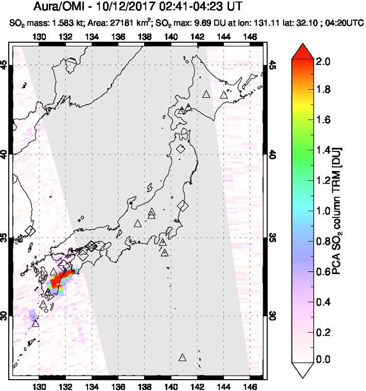 |
Figure 27. A significant SO2 plume from the explosion at the Shinmoedake crater of Kirishimayama was measured on 12 October 2017 by NASA's OMI instrument on the Aura satellite. Courtesy of NASA Goddard Space Flight Center. |
Explosions on 14 October 2017 resulted in confirmed ashfall in Kagoshima city (50 km SW), Takahara Town (15 km E), Kobayashi city (25 km NE), Saito city (55 km NE), Hyuga city (90 km NE), and Misato town (75 km NE). Ongoing explosions continued until 17 October, after which persistent steam plumes were observed rising as high as 600 m above the crater. In an overflight conducted on 23 October JMA scientists noted the new vent was about 80 m in diameter, and ejecta from the vent had formed a small cone around the vent. (figure 28).
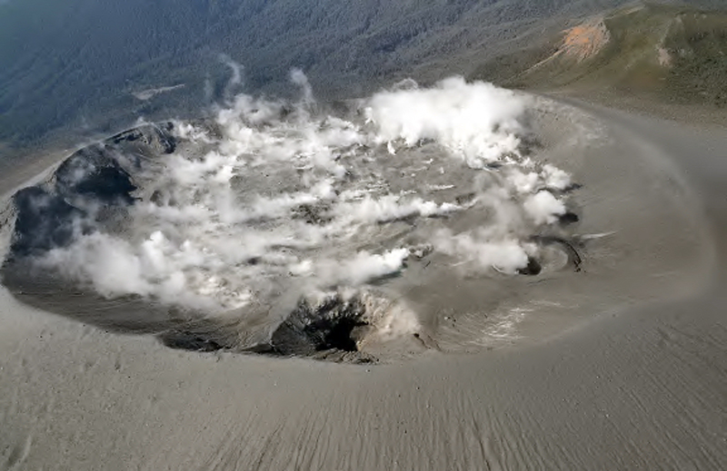 |
Figure 28. Two vents were visible on the E side of the crater in this view to the WNW taken on 23 October 2017 of Shinmoedake crater at Kirishimayama. The left vent (center front) had formed during the 2011 eruption, and the right vent formed during the 11-17 October 2017 eruption earlier in the month. Courtesy of JMA (Volcanic activity commentary on Kirishimayama, October, Heisei 29 (2017)). |
Activity at Shinmoedake during November 2017-March 2018. After the eruption of 11-17 October 2017 seismicity decreased significantly, and no morphological changes were observed for the remainder of the year. Steam plumes rose 300-500 m above the crater during November and December. Short-duration tremors were detected during 25-29 November, along with a slight increase in the number of volcanic earthquakes. A small earthquake swarm recorded during 2-4 December was the only significant seismic activity that month.
Infrequent, large-amplitude earthquakes were recorded during 15-17 January 2018, along with a few short-duration tremor events, the first since 29 November 2017. The earthquakes were located within a 1 km radius of Shinmoedake, around 2-4 km deep. Steam plumes at the crater rose no more than 100 m most days; occasional plumes rising as high as 200 m were noted. An earthquake swarm on 25 February was the first notable event of the month; the steam plumes remained under 100 m above the crater, except for a 500-m-high plume on 21 February. Thermal imaging surveys in late February indicated a modest increase in heat flow from fractures inside the crater and on the W slope compared with previous measurements.
Earthquakes with shallow epicenters below Shinmoedake increased in number early on 1 March 2018 and a new eruptive episode followed a few hours later, leading JMA to increase the restricted zone to 3 km around the crater (figure 29). SO2 emissions also increased sharply. By the afternoon of 1 March an ash plume rose 1,500 m above the crater, emerging from the vent on the E side and drifting SE. Ashfall was confirmed on 1 March in the area up to 18 km E of the crater. Large blocks of ejecta were observed within the crater on 5 March.
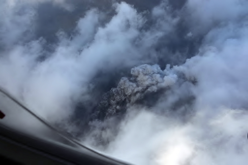 |
Figure 29. A new eruptive episode at the Shinmoedake crater of Kirishimayama began around 1100 on 1 March 2018 with ash emissions emerging from the new vent on the E side of the crater. Courtesy of JMA (Volcanic activity commentary on Kirishimayama, February, Heisei 30 (2018)). |
During an overflight on 6 March 2018, JMA witnessed a new lava flow covering a large area on the E side of the crater floor (figure 30). Eighteen explosive eruptions occurred on 6 March and JMA reported that the ash plume rose 2,800 m above the crater (figure 31). Ashfall was confirmed SW of Shinmoedake in Shibushi city (50 km SSE), Tarumizu City (50 km SSW) and Aira City (30 km SW). NASA 's Aqua satellite captured a false color image of the eruption on 6 March showing the ash plume drifting SE and SW from Shinmoedake (figure 32). About 80 flights in and out of nearby Kagoshima airport were canceled.
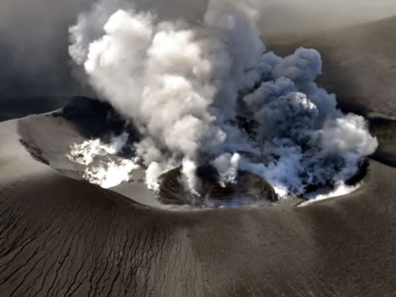 |
Figure 30. Lava emerged from the new vent on the E side of the Shinmoedake crater at Kirishimayama on 6 March 2018 in this view to the W. Plumes of both ash and steam rose from the center and N sides of the crater. Courtesy of JMA (Volcanic activity commentary on Kirishimayama, February, Heisei 30 (2018)). |
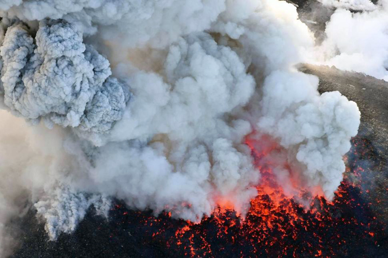 |
Figure 31. Ash and steam rose from newly emergent lava inside the summit crater of Shinmoedake at Kirishimayama on 6 March 2018, and disrupted air traffic for most of the day. Courtesy of Kyodo News via AP. |
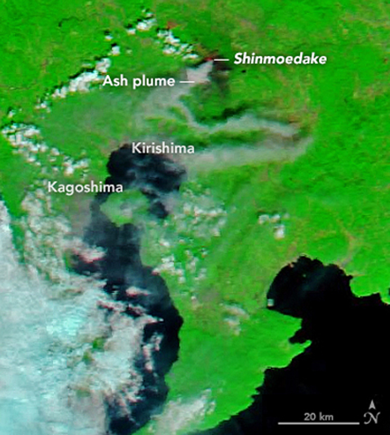 |
Figure 32. NASA 's Aqua satellite captured a false color image of the eruption from Shinmoedake crater at Kirishimayama on 6 March 2018 with an ash plume drifting SE and SW. Courtesy of NASA Earth Observatory. |
Tremor events occurred continuously over 1-8 March; forty-seven explosions were recorded between 6 and 8 March; they decreased in frequency after the middle of the month. The OMI instrument on the NASA Aura satellite recorded a significant SO2 plume on 7 March 2018 (figure 33). Geospatial data that had shown a gradual inflation of the Kirishimayama complex since July 2017 showed a sharp deflation during 6-7 March 2018, after which inflation resumed.
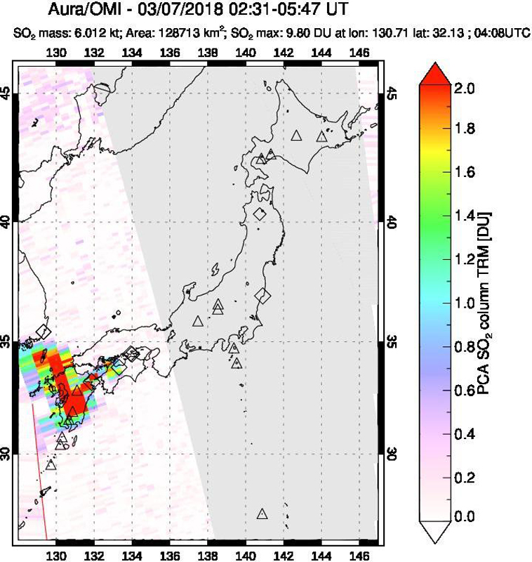 |
Figure 33. An SO2 plume with a density of almost ten Dobson Units (DU) was recorded by the OMI instrument on the Aura satellite on 7 March 2018. Courtesy of NASA Goddard Space Flight Institute. |
During an overflight on 9 March 2018, a staff member from the Geographical Survey Institute observed the lava flow beginning to overflow the NW side of the crater (figure 34). Explosions resulted in ejecta traveling 800 m from the crater on 9 March and an ash plume rising 3,200 m. An increase in the intensity of activity the following day sent ejecta 1,800 m from the vent and generated an ash plume that rose 4,500 m (figure 35); this led JMA to increase the restricted area around the crater to 4 km between 10 and 15 March.
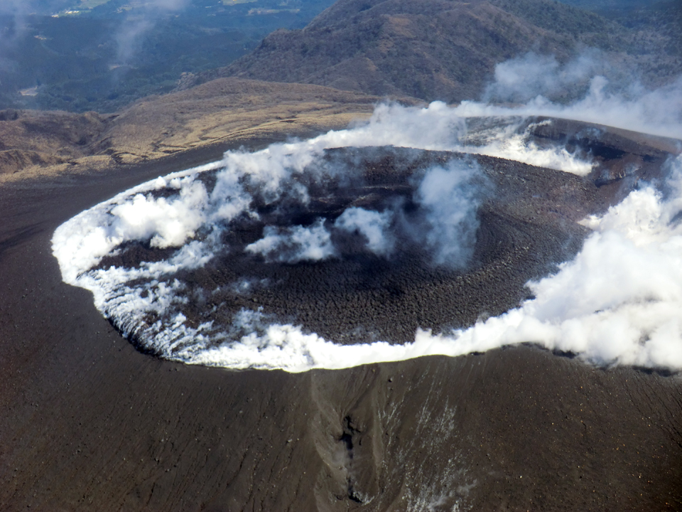 |
Figure 34. The new lava flow began to overtop the NW side of Shinmoedake crater (left side of crater with steam) at Kirishimayama on 9 March 2018. Photographed by a staff member from the Geographical Survey Institute during a helicopter overflight by the Kyushu Regional Development Bureau. Courtesy of the Geographical Survey Institute (Correspondence on the eruption of Kirishimayama (Shinmoedake) in Heisei 30 (2018), 29 March 2018). |
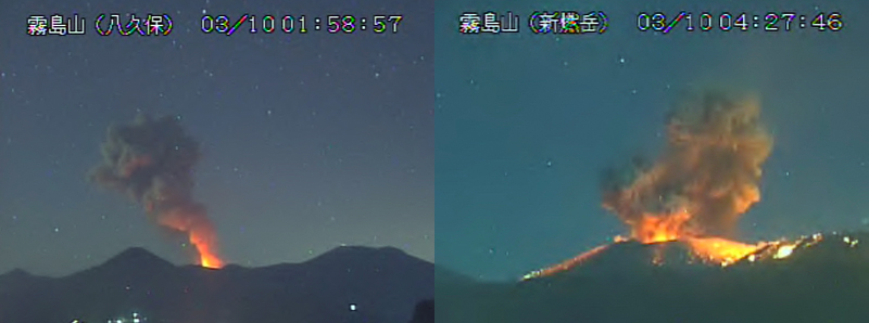 |
Figure 35. An increase in explosive activity at the Shinmoedake crater of Kirishimayama on 10 March 2018 sent an ash plume 4,500 m above the crater (left), and incandescent ejecta 1,800 m from the vent (right). Courtesy of JMA (Volcanic activity commentary on Kirishimayama, March, Heisei 30 (2018)). |
A thermal image taken on 11 March showed that the lava was moving very slowly down the NW flank, advancing only a few tens of meters since 9 March (figure 36). JMA confirmed during an overflight on 14 March that the lava flowing down the NW flank was about 200 m wide. Two explosions on 25 March produced plumes that rose 3,200 and 2,100 m, ejecta that traveled 800 m, and a small pyroclastic flow that advanced about 400 m down the W flank (figure 37). Although analysis of satellite data by Japan's Geographical Survey Institute suggested that the eruption of lava into the crater had ceased by 9 March, it continued to flow slowly down the NW flank for several weeks. The diameter of the flow inside the crater was about 700 m, and it had traveled about 85 m down the NW flank by 28 March (figure 38).
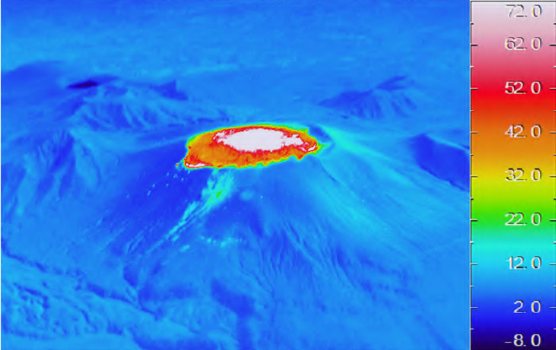 |
Figure 36. A thermal image taken on 11 March 2018 of the new lava flow in the Shinmoedake crater at Kirishimayama showed the slow movement of the flow over the NW rim and down the flank a few tens of meters in two days. Courtesy of JMA (Volcanic activity commentary on Kirishimayama, March, Heisei 30 (2018)). |
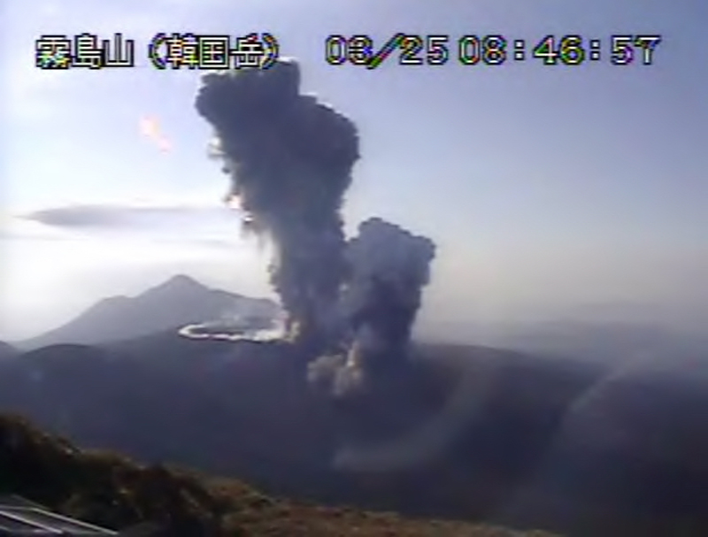 |
Figure 37. Two explosions on 25 March 2018 from Shinmoedake crater at Kirishimayama produced plumes that rose 3,200 and 2,100 m, ejecta that traveled 800 m, and a small pyroclastic flow that advanced about 400 m down the W flank (foreground). Courtesy of JMA (Volcanic activity commentary on Kirishimayama, March, Heisei 30 (2018)). |
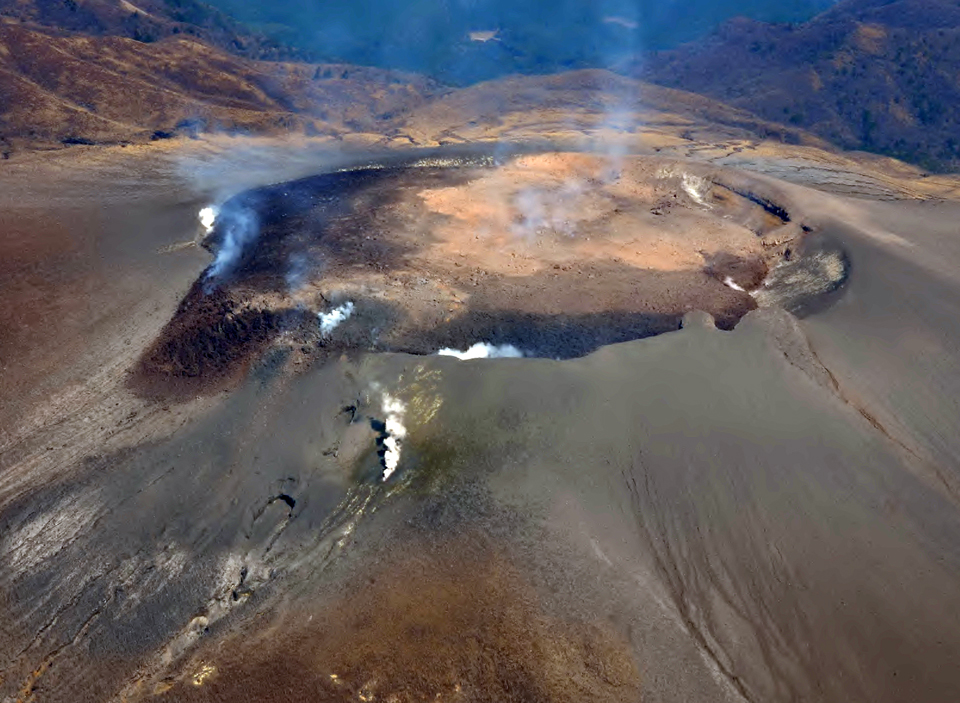 |
Figure 38. Lava was still slowly moving down the NW flank of the Shinmoedake crater at Kirishimayama on 26 March 2018, and gray ash covered much of the adjacent flank, possibly from a pyroclastic flow the previous day. Courtesy of JMA (Volcanic activity commentary on Kirishimayama, March, Heisei 30 (2018)). |
The Tokyo VAAC issued multiple daily reports from 1-15 March 2018, and a few intermittent reports during the rest of the month. JMA usually reports plume heights in meters above the crater and the Tokyo VAAC reports them as altitudes above sea level; conversions are noted where the height or altitude of a plume is exceptional. They reported an ash plume drifting SE on 1 March at 1.5 km altitude; the plume had risen to 2.4 km by the end of the day. The following day a plume was visible in satellite images at 2.1 km altitude drifting E. Continuous emissions drifting NE above 2.4 km altitude were reported on 3 and 4 March. Several explosions generated plumes that were visible in satellite imagery during 5-7 March drifting S, SW, and W at altitudes between 3.0 and 4.6 km. Plumes from larger explosions during 9 and 10 March rose to altitudes between 4.3 and 6.1 km and drifted SE, finally dissipating after about 24 hours. Explosions on 12 and 13 March drifted NE and E at 3.4-4.9 km altitude, with continuous emissions visible in satellite imagery during those days. Two explosions on 24 March produced plumes that drifted SE at 3.7 and 4.9 km altitude, and were visible in satellite imagery until they dissipated the next day.
A strong MIROVA thermal anomaly signal appeared at the beginning of March and slowly tapered off into April. The signal is consistent with the reports of the eruption of lava from the summit of Shinmoedake and its gradual cooling (figure 39). The MODVOLC thermal alert signals also closely match the reports of the eruption of the lava. The first six alerts were issued on 6 March, four each on 9 and 10 March, three each on 11 and 12 March, and one each on 13, 14, 16, 23, and 30 March, matching a gradual cooling pattern for the lava after the main eruptive event.
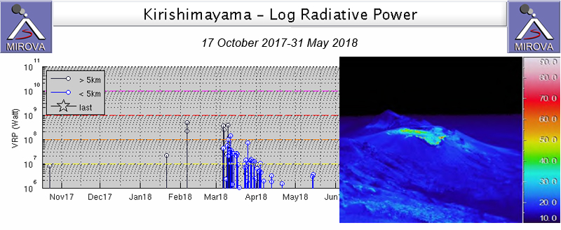 |
Figure 39. A strong MIROVA thermal anomaly signal appeared at Kirishimayama at the beginning of March and slowly tapered off into April 2018. The signal is consistent with the reports of the eruption of lava from the summit of Shinmoedake, and its gradual cooling. A thermal image of the lava flow at Shinmoedake from 28 March 2018 (inset) shows significant cooling from two weeks earlier (see figure 36). Courtesy of MIROVA and JMA (Volcanic activity commentary on Kirishimayama, March, Heisei 30 (2018)). |
Activity at Shinmoedake during April and May 2018. A new explosion on 5 April 2018 generated a large ash plume that rose 5,000 m above the crater; a small pyroclastic flow traveled 400 m down the SE flank, and ejecta was thrown 1,100 m from the vent (figure 40). The Tokyo VAAC reported an explosion, and an ash plume at 6.7 km altitude drifting E visible in satellite imagery early in the day. A few hours later, the plume was visible at 10.1 km altitude, or more than 8,000 m above the crater. Incandescent tephra was ejected hundreds of meters high, and lightning was observed within the large ash plume (figures 41 and 42). The plume was observed continuously in satellite images for almost 24 hours before dissipating; a significant SO2 plume was also recorded (figure 43).
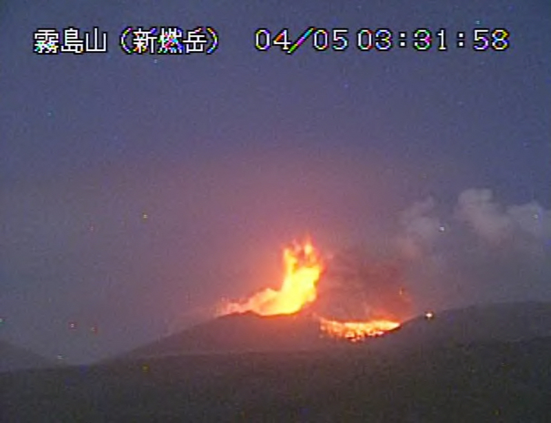 |
Figure 40. Ejecta was thrown 1,100 m from the vent in an explosion at the Shinmoedake crater of Kirishimayma on 5 April 2018 (farthest right incandescence). A large ash plume (to the right of the main incandescence) eventually rose to over 8,000 m above the crater. View is to the N from the Inogishi webcam. Courtesy of JMA (Volcanic activity commentary on Kirishimayama, April, Heisei 30 (2018)). |
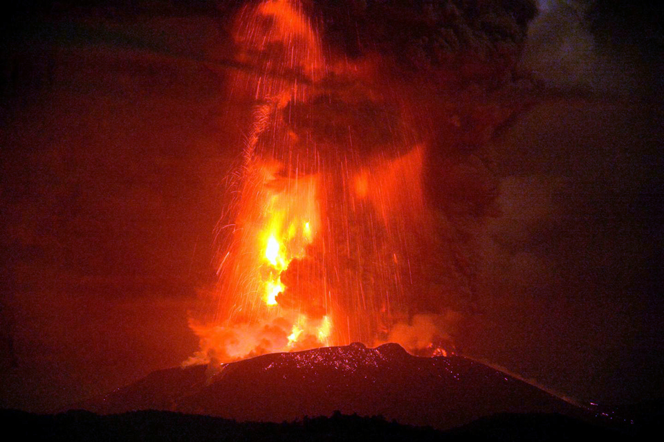 |
Figure 41. An explosion on 5 April 2018 from the Shinmoedake crater at Kirishimayama sent incandescent ejecta several hundred meters above the crater. Courtesy of Kyodo News via Reuters. |
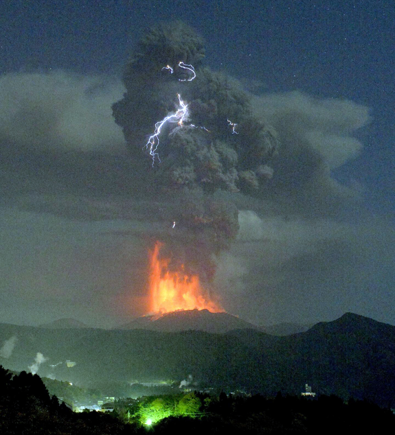 |
Figure 42. Significant lightning was reported in the large ash plume from the 5 April 2018 explosion at the Shinmoedake summit crater at Kirishimayama. Courtesy of Kyodo News via Reuters. |
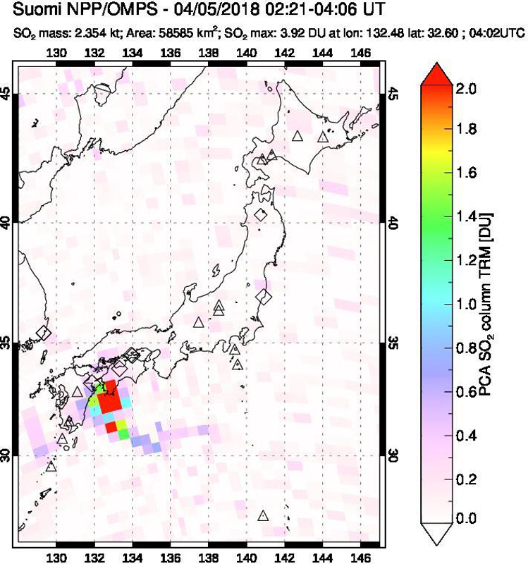 |
Figure 43. The OMPS instrument on the Suomi NPP satellite recorded an SO2 plume drifting SE after the 5 April 2018 explosion at the Shinmoedake crater of Kirishimayama. Courtesy of NASA Goddard Space Flight Center. |
A large amount of ashfall was reported in parts of Kobayashi city and Takaharu (15 km E) (figures 44 and 45) on 5 April 2018. Ashfall reports also indicated that a wide area to the N of Shinmoedake including Hitoyoshi City (30 km N), to the NE including Kadogawa Town (95 km NE), and to the E including Miyazaki City (50 km E) were also affected. Another eruption took place the following day, on 6 April, but weather clouds obscured views of the summit. No eruptions were recorded after 6 April for the remainder of the month.
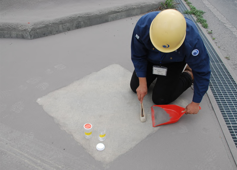 |
Figure 44. Ashfall was measured and sampled on 5 April 2018 in Kobayashi City (25 km NE) after an explosion with a large ash plume rose from the Shinmoedake crater at Kirishimayama. Courtesy of JMA (Volcanic activity commentary on Kirishimayama, March, Heisei 30 (2018)). |
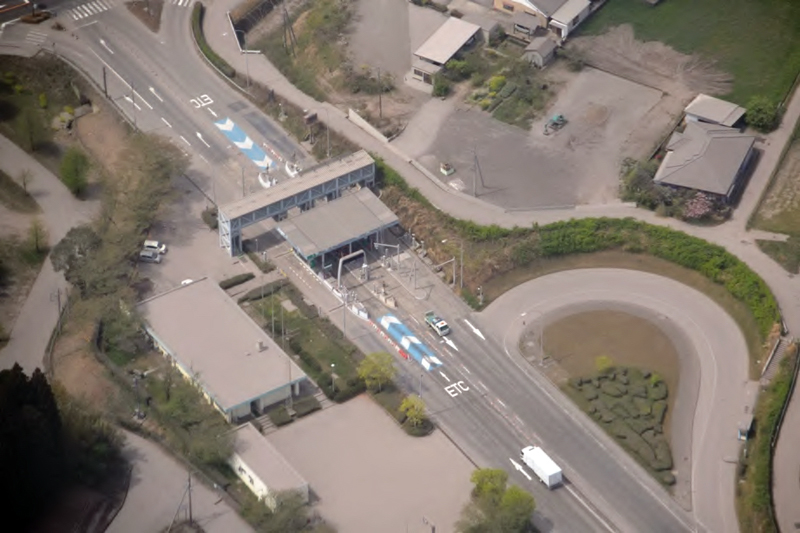 |
Figure 45. Ashfall covered major roadways and buildings in Takaharu, 15 km E of Kirishimayama, after an explosion from the Shinmoedake crater on 5 April 2018. Courtesy of JMA (Volcanic activity commentary on Kirishimayama, March, Heisei 30 (2018)). |
In multiple flyovers, on 19, 20, and 21 April 2018, authorities observed lava continuing to flow down the NW flank (figure 46), along with residual high temperatures in the central part of the lava flow (figure 47). Additionally, fumarolic areas around the fractures on the W slope persisted. By the end of April, the flow on the NW flank of the crater was 150 m long. Seismicity had declined at the end of March, but increased again during the explosive period in early April. Occasional tremors were recorded during 5-14 April. Intermittent spikes of around 100 small earthquakes were also recorded on 14 and 21 April.
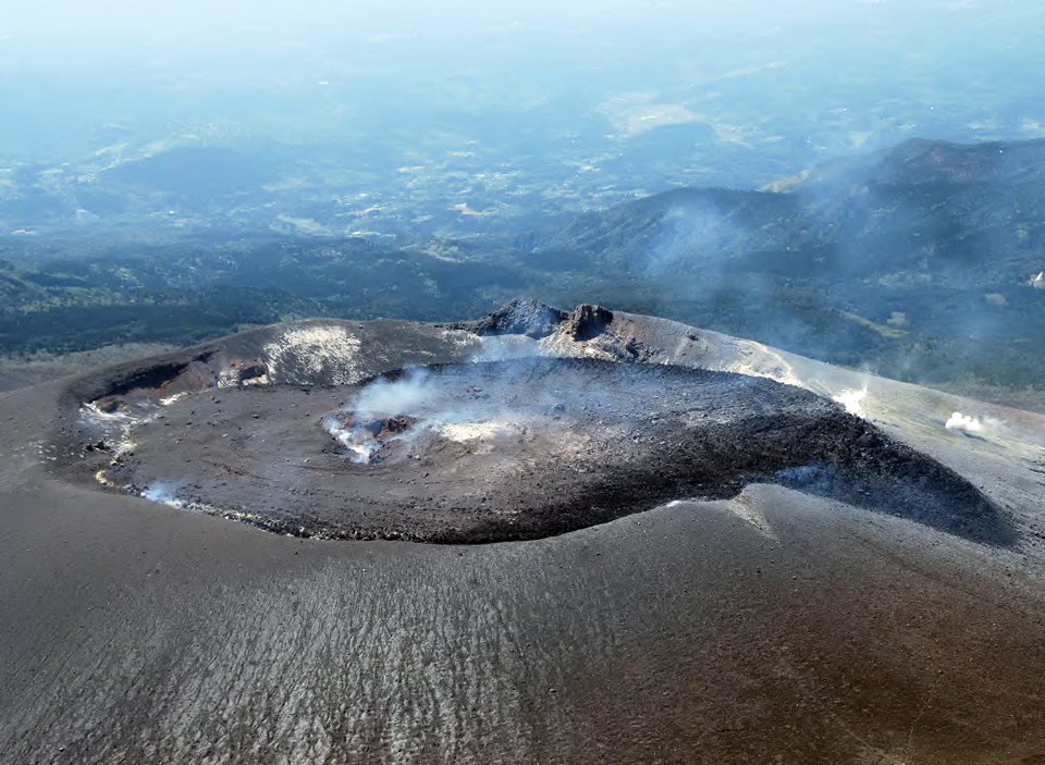 |
Figure 46. The lava flow down the NW flank of Shinmoedake crater at Kirishimayama was nearly stagnant by 21 April 2018, as seen in this view to the SW taken that same day by the Miyazaki Prefecture Disaster Preparedness Emergency Air Corps. Courtesy of JMA (Volcanic activity commentary on Kirishimayama, April, Heisei 30 (2018)). |
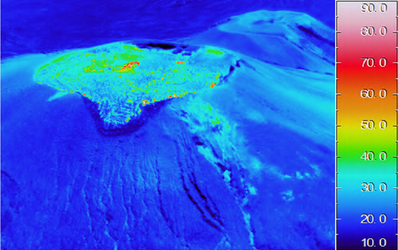 |
Figure 47. Residual high heat flow was still visible near the center of the Shinmoedake crater of Kirishimayama on 21 April 2018 but the lava flow had cooled significantly since March (compare with figure 36). Courtesy of JMA (Volcanic activity commentary on Kirishimayama, April, Heisei 30 (2018)). |
Another spike in earthquakes with epicenters within 2 km of Shinmoedake occurred on 2 May 2018 with over 700 events recorded. A substantial explosion on 14 May generated an ash plume that rose 4.5 km above the crater according JMA (figure 48). The Tokyo VAAC reported the ash plume initially at 4.9 km altitude drifting SE based on webcam reports; when the plume appeared in satellite data a short time later it was drifting SE at 7.3 km altitude and was continuously visible in satellite imagery for about 24 hours before dissipating. Ashfall was confirmed in numerous areas of the Miyazaki prefecture to the E, and the Kagoshima prefecture to the S and W. Seismicity increased briefly after the explosion. Enough ash fell in Miyakonojo City (30 km S) that it covered the white lines on the roadways (figure 49). A thermal image taken on 15 May showed a new high-heat flow area on the E side of the new lava flow inside the crater that JMA concluded was likely the result of the explosive event of the previous day (figure 50).
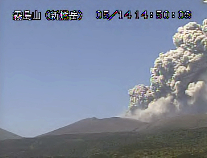 |
Figure 48. A large explosion at the Shinmoedake crater of Kirishimayama on 14 May 2018 sent an ash plume to 4,500 m above the crater as seen in this view to the NE from the Inogishi webcam. Courtesy of JMA (Volcanic activity commentary on Kirishimayama, May, Heisei 30 (2018)). |
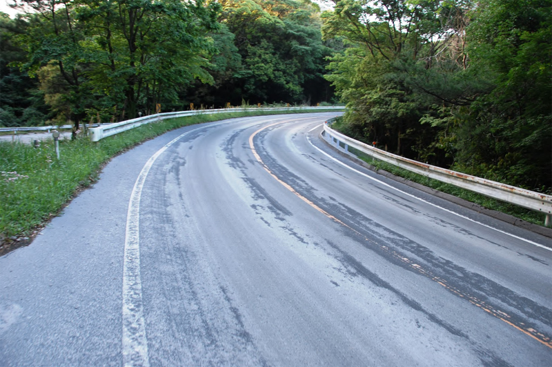 |
Figure 49. Enough ash fell in Miyakonojo City (30 km S) after an explosion at Shinmoedake crater of Kirishimayama on 14 May 2018, that it covered the white lines on the roadways. Courtesy of JMA (Volcanic activity commentary on Kirishimayama, May, Heisei 30 (2018)). |
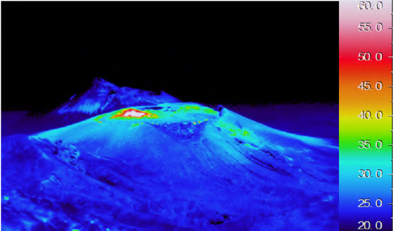 |
Figure 50. The thermal signature at Shinmoedake crater at Kirishimayama on 15 May 2018 revealed a high-heat flow area that JMA concluded likely resulted from the explosion the previous day. Courtesy of JMA (Volcanic activity commentary on Kirishimayama, May, Heisei 30 (2018)). |
Activity at Iwo-yama during 2014-2017. An increase in seismicity around Iwo-yama, on the NW flank of the Karakunidake stratovolcano (figure 22) beginning in December 2013 was noted by JMA. The epicenters were distributed from 1-6 km below Iwo-yama. Satellite measurements suggested minor inflation in the area around Karakunidake beginning in December 2013, which lasted until January 2015. A 7-minute-long tremor event occurred near Iwo-yama on 20 August 2014. Although inspections of the area by JMA revealed no thermal or fumarolic activity, they listed the Iwo-yama area with an unofficial Alert Level of "Danger around the crater" on 24 October 2014, equivalent to the official Alert Level 2. They modified the warning during May 2015 to "Normal, keep in mind, it is an active volcano," the same as the official Alert Level 1. During the second half of 2015 there were occasional earthquakes and tremors reported in the area, but no surface or thermal activity was recorded (figure 51) until December. Thermal anomalies appeared in the area for the first time during the first week of December 2015; weak fumarolic activity accompanied by H2S odors were first reported during 15-17 December 2015 on the SW side of the Iwo-yama crater (figure 52).
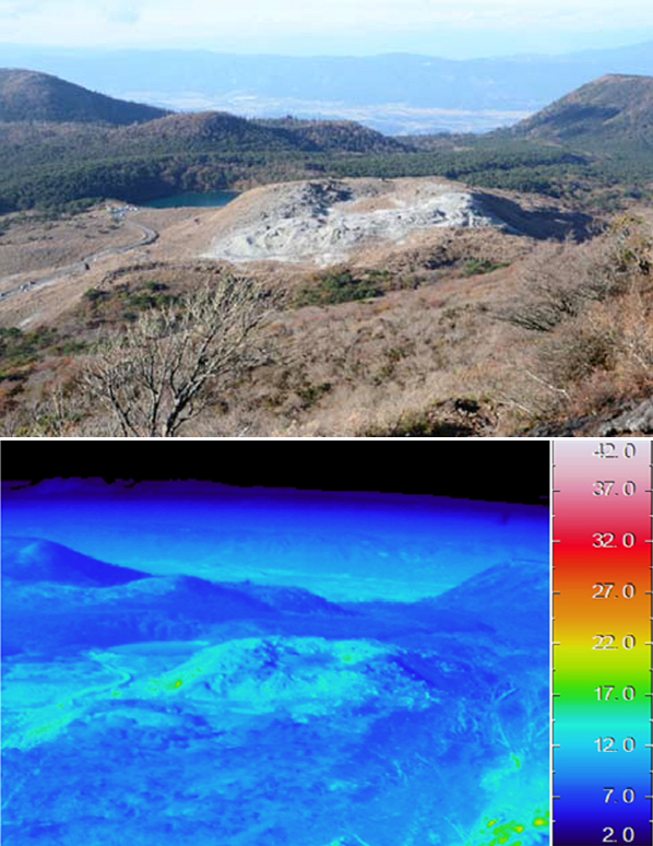 |
Figure 51. No surface activity, and very little thermal activity was present at the Iwo-yama (Ebino Kogen) area of Kirishimayama on 2 November 2015. View is to the N, taken from the N flank of Karakunidake. Courtesy of JMA (JMA Kirishimayama annual report, Heisei 27 (2015)). |
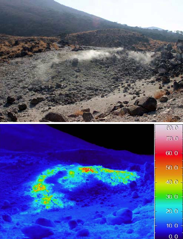 |
Figure 52. Steam plumes and a thermal anomaly at the Iwo-yama area of Kirishimayama first appeared during December 2015 (images from 28 December 2015, view to the S). Courtesy of JMA (JMA Kirishimayama annual report, Heisei 27 (2015)). |
Periods of intermittent microtremor activity occurred once in January, four times in February, and twice in December during 2016, with durations ranging from 40 seconds to 5 minutes. A seismic swarm on 28 February led JMA to raise the unofficial Alert Level to "danger around the crater" for the month of March (equivalent to the official Alert Level 2). A new thermal area with fumarolic activity appeared on 24 March 2016 on the SE side of the crater. Intermittent steam plumes were observed throughout 2016; the highest rose 200 m on 11 October. Thermal anomalies also persisted throughout the year on the S and SW areas of the crater. Alert Level 1 (Note that it is an active volcano) was formally assigned to Iwo-yama on 6 December 2016. The Alert Level was raised to 2 on 12 December after a seismic swarm, tremor, and the observation of inflation in the inclination data in the previous days.
Fumarolic activity decreased in January 2017 after a brief increase at the end of December 2016; JMA lowered the Alert Level back to 1 on 13 January and steam plumes generally rose only 30 m high during the month. The thermal anomalies persisted in the same areas of the SW and W portions of the crater as before, though new fumarolic activity appeared in those areas during February 2017. During March field surveys, observers identified hot water emerging from the fumaroles in the SW and S areas of the crater. The inclinometer detected inflation beginning on 25 April 2017, but it leveled off during August. An increase in the number of fumaroles in the area of the thermal anomaly at the SW side of the crater was confirmed by a JMA field inspection in late April. When the University of Tokyo Earthquake Research Institute visited the site on 8 May 2017, they observed sediment-laden water deposits that had been dispersed on the SW side within the crater, and ejecta around the SW edge. This led JMA to increase the Alert Level to 2.
Fumarolic activity increased during mid-to-late July 2017 and steam plumes were reported at 300 m above the crater for a brief period. On 27 July visitors confirmed dead and discolored plants on the NE side of the crater, and audible fumarolic activity. A new thermal anomaly zone with fumaroles was visible on the SW flank outside the crater during a site visit on 31 August. Low levels of seismicity were intermittent throughout 2017, but no tremor events were recorded. A large amplitude earthquake with its epicenter under Iwo-yama occurred on 5 September 2017; no sudden changes were observed at the site a few days later, although thermal images taken on 9 September revealed an increase in temperature from two years prior (figure 53, compared with figure 52). JMA lowered the warning level to 1 at the end of October. During November and December 2017, steam plumes generally rose 100-200 m above the crater.
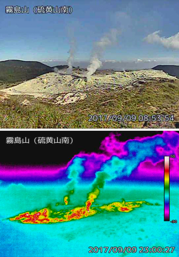 |
Figure 53. Steam plumes and a thermal anomaly persisted into September 2017 at the Iwo-yama crater of Kirishimayama. Emissions of the plume on the left were audible during the July visit. Compare with the lower temperatures measured in December 2015, figure 52. Image taken on 9 September 2017 from the Iwomayama South webcam on the S side of the area. Courtesy of JMA (JMA Kirishimayama annual report, Heisei 29 (2017)). |
Activity at Iwo-yama during January-May 2018. An analysis of nearby hot-spring waters indicated a significant jump in Cl/SO4 ratios characteristic of high-temperature volcanic gas beginning in November 2017. The first tremor since 12 December 2016 was recorded on 19 January 2018 and coincided with a brief period of inflation in the vicinity of Iwo-yama. Regional inflation of the area had begun again in July 2017 and continued into 2018. Low-frequency, small-amplitude earthquakes were intermittent during January 2018 and steam plumes rose 100-200 m. Increases in seismicity, fumarolic activity, and the temperatures of the thermal anomalies during mid-February 2018 prompted JMA to raise the Alert Level on 20 February 2018 at Iwo-yama to 2. Steam plume heights increased to 200-300 m after 20 February. Seismicity decreased during March 2018, however observations from the webcam revealed an increase in fumarolic and thermal activity (figure 54).
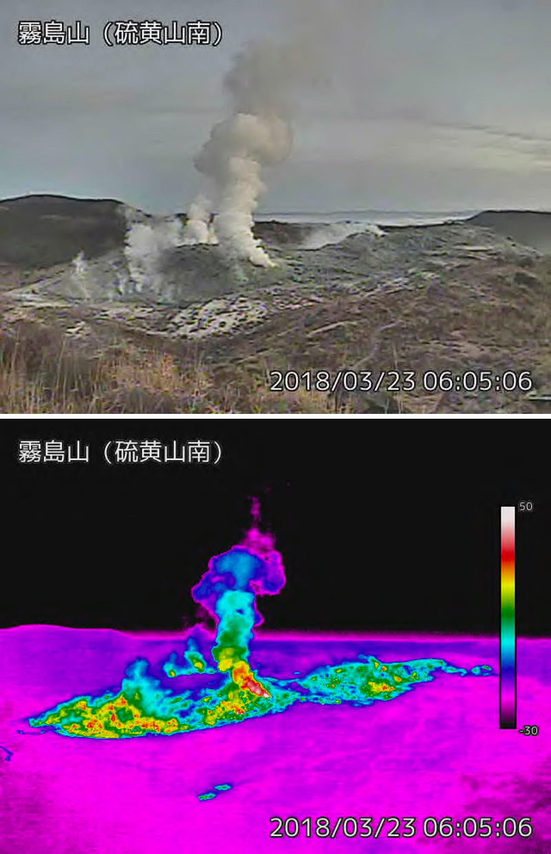 |
Figure 54. Fumarolic activity and heatflow increased at the Iwo-yama crater of Kirishimayama during March 2018, with steam plumes at the central vent rising several hundred meters. Images taken on 23 March 2018. View is to the N from the Iwo-yama south webcam. Courtesy of JMA (Volcanic activity commentary on Kirishimayama, March, Heisei 30 (2018)). |
The infrared imaging webcam recorded a burst of heat from a vent on the SW side of the crater on 7 April; the amplitude of seismic vibrations also increased. A field visit on 9 April revealed a hot water pool several meters in diameter on the SW side of the crater with sediment-laden water flowing from it and a 10-m-high steam plume. Local inflation recorded at Iwo-yama turned to deflation on 19 April; large-amplitude earthquakes were also reported. A tremor that day was followed by an explosion a few minutes later from a new vent on the S side of Iwo-yama. The plume rose 500 m and ejecta was scattered 200-300 m from the vent to the SE. During an overflight on 19 April JMA noted ash deposits around the vent; ash emission from the vent continued until the following morning (figure 55). The Tokyo VAAC reported a small ash emission on 19 April from Kirishimayama that rose to 1.8 km altitude and drifted E, but it was not visible in satellite imagery. On the evening of 20 April, another new vent with a vigorous steam plume appeared 500 m W of Iwo-yama (figure 56). Sediment-laden water was observed around the vent the following day. Increased seismicity at Iwo-yama lasted for about 20 days; additional tremor activity was reported on 20 and 24 April.
 |
Figure 55. An explosion sent steam and ash 500 m high, and ejecta 200-300 m SE from a new vent on the S side of Iwo-yama on 19 April 2018 at Kirishimayama. Ash emission continued until the following morning. N is to the left, fresh ash deposits cover the area SE of the new vent (upper right). Courtesy of JMA (Volcanic activity commentary on Kirishimayama, April, Heisei 30 (2018)). |
 |
Figure 56. A new fumarole with a vigorous steam plume appeared about 500 m W of Iwo-yama during the evening of 20 April 2018. N is to the left. Miyazaki Prefecture Disaster Preparedness Emergency Air Corps Photograph taken from a helicopter on 21 April 2018. Courtesy of JMA (Volcanic activity commentary on Kirishimayama, April, Heisei 30 (2018)). |
A brief explosion that lasted about ten minutes occurred from this new vent around 1815 on 26 April 2018 sending a plume of ash about 200 m above the vent (figure 57). A small ash emission from Kirishimayama was reported by the Tokyo VAAC on 26 April that rose to 1.5 km altitude. In a site visit on 30 April, JMA noted active fumaroles and small explosions around both vent areas (figure 58). After the explosion of 19 April, steam plumes rose as high as 700 m from the vent on the S side of the crater, and intermittent spouts a few meters high of sediment-laden water were also observed. Steam plumes rose as high as 500 m from the vent located 500 m to the W.
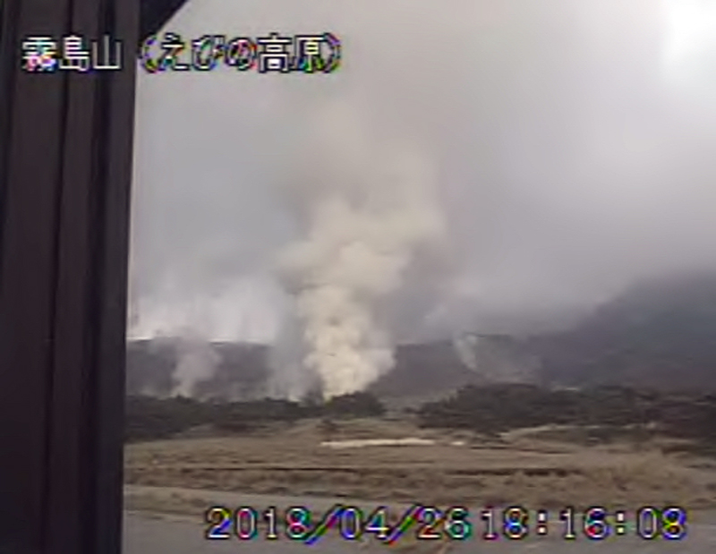 |
Figure 57. An explosion from the new vent located 500 m W of Iwo-yama at Kirishimayama on 26 April 2018 sent ash 200 m above the vent. Courtesy of JMA (Volcanic activity commentary on Kirishimayama, April, Heisei 30 (2018)). |
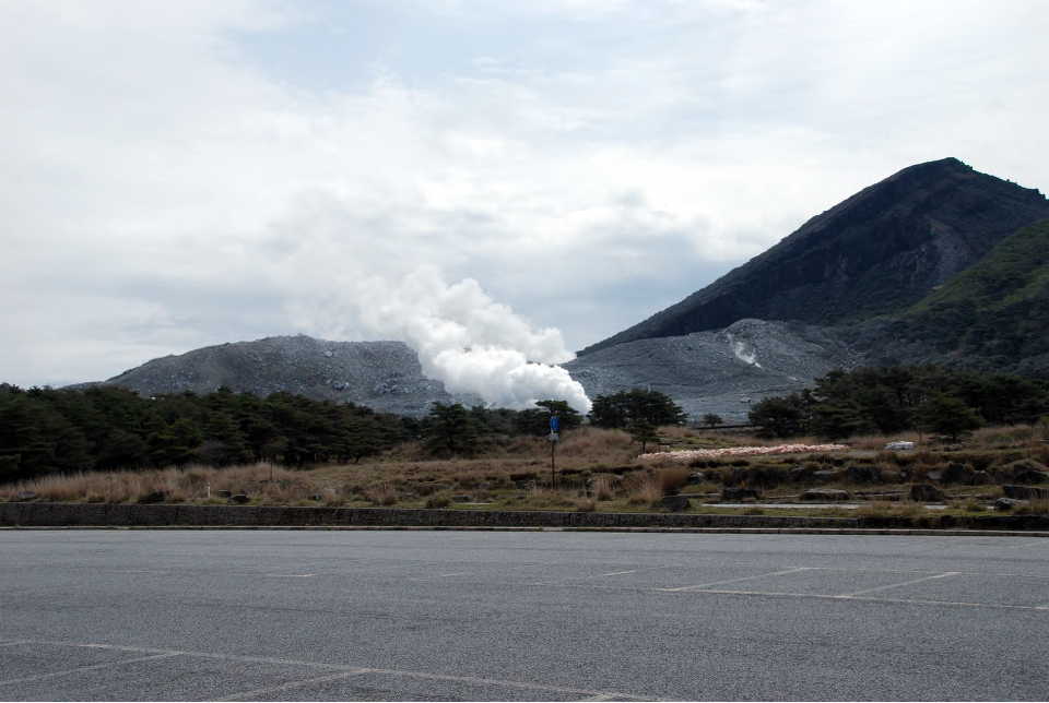 |
Figure 58. Vigorous steam plumes rose from both the S side vent at Iwo-yama (background) and the new vent 500 m W (foreground) on 30 April 2018 at the Kirishimayama complex. North is to the left. Courtesy of JMA (Volcanic activity commentary on Kirishimayama, April, Heisei 30 (2018)). |
Fumarolic activity continued at Iwo-yama during May 2018, but no new explosions nor ash emissions were reported. Shallow seismic events were intermittent, but significantly decreased from April. No tremors were recorded. JMA lowered the Alert Level on 1 May 2018 from 3 to 2. Steam plumes rose 300-500 m from the vents, and thermal anomalies persisted at the crater and the adjacent new vent to the W throughout the month. Jets of sediment-laden hot water rising several meters continued from the vent on the S side of Iwo-yama (figure 59).
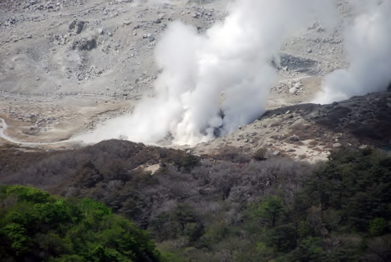 |
Figure 59. Jets of sediment-laden hot water (gray spout at center) rose several meters from the S vent at Iwo-Yama at Kirishimayama during May 2018. Image taken on 15 May 2018. Courtesy of JMA (Volcanic activity commentary on Kirishimayama, April, Heisei 30 (2018)). |
Geological Summary. Kirishimayama is a large group of more than 20 Quaternary volcanoes located north of Kagoshima Bay. The late-Pleistocene to Holocene dominantly andesitic group consists of stratovolcanoes, pyroclastic cones, maars, and underlying shield volcanoes located over an area of 20 x 30 km. The larger stratovolcanoes are scattered throughout the field, with the centrally located Karakunidake being the highest. Onamiike and Miike, the two largest maars, are located SW of Karakunidake and at its far eastern end, respectively. Holocene eruptions have been concentrated along an E-W line of vents from Miike to Ohachi, and at Shinmoedake to the NE. Frequent small-to-moderate explosive eruptions have been recorded since the 8th century.
Information Contacts: Japan Meteorological Agency (JMA), Otemachi, 1-3-4, Chiyoda-ku Tokyo 100-8122, Japan (URL: http://www.jma.go.jp/jma/indexe.html); NASA Goddard Space Flight Center (NASA/GSFC), Global Sulfur Dioxide Monitoring Page, Atmospheric Chemistry and Dynamics Laboratory, 8800 Greenbelt Road, Goddard, Maryland, USA (URL: https://so2.gsfc.nasa.gov/); NASA Earth Observatory, EOS Project Science Office, NASA Goddard Space Flight Center, Goddard, Maryland, USA (URL: http://earthobservatory.nasa.gov/); MIROVA (Middle InfraRed Observation of Volcanic Activity), a collaborative project between the Universities of Turin and Florence (Italy) supported by the Centre for Volcanic Risk of the Italian Civil Protection Department (URL: http://www.mirovaweb.it/); Hawai'i Institute of Geophysics and Planetology (HIGP) - MODVOLC Thermal Alerts System, School of Ocean and Earth Science and Technology (SOEST), Univ. of Hawai'i, 2525 Correa Road, Honolulu, HI 96822, USA (URL: http://modis.higp.hawaii.edu/); Geographical Survey Institute, Geospatial Information Authority of Japan, Ministry of Land, Infrastructure, Transport and Tourism, No. 1 North Town, Tsukuba city, Ibaraki Prefecture 305-0811 Japan Tel: 029-864-1111 (Representative) Fax: 029-864-1807 (URL: http://www.gsi.go.jp/index.html); Kyodo News (URL: https://www.kyodonews.jp/english/); Associated Press (URL: http://www.ap.org/ ); Reuters (http://www.reuters.com/).