Report on San Miguel (El Salvador) — June 2018
Bulletin of the Global Volcanism Network, vol. 43, no. 6 (June 2018)
Managing Editor: Edward Venzke.
Research and preparation by Jackie Gluck.
San Miguel (El Salvador) Intermittent small ash emissions between 14 January and 30 May 2018
Please cite this report as:
Global Volcanism Program, 2018. Report on San Miguel (El Salvador) (Venzke, E., ed.). Bulletin of the Global Volcanism Network, 43:6. Smithsonian Institution. https://doi.org/10.5479/si.GVP.BGVN201806-343100
San Miguel
El Salvador
13.434°N, 88.269°W; summit elev. 2130 m
All times are local (unless otherwise noted)
El Salvador's San Miguel, also known as Chaparrastique, had six small ash emission events during January 2015-June 2017 (BGVN 42:07). New activity consisting of intermittent ash emissions began on 14 January and continued until 30 May 2018, reported below based on information provided by El Salvador's Servicio Nacional de Estudios Territoriales (SNET) and special reports from the Ministero de Medio Ambiente y Recursos Naturales (MARN).
SNET and MARN reported that during 14-17 January 2018 there were four gas-and-ash emissions from San Miguel that rose no higher than 300 m above the crater rim, at least one of which dispersed SW. The reports noted that prior to each emission seismicity decreased and then suddenly increased. MARN reported that during 25-26 January seismic tremor levels fluctuated between 75 and 179 RSAM (Real-time Seismic Amplitude Measurement) units per hour on average, slightly above normal (50-150 units).
On 19 February, MARN reported the beginning of sustained gas emissions along with small ash emissions. The plume did not exceed 350 m above and was displaced by winds to the SW. This activity was similar to the activity on 14-15 January 2018.
SNET reported on 2 March that gas plumes rose as high as 400 m above the crater rim during the previous week. Ash appeared in "gas pulse" emissions on 24, 26, and 28 February, and 1 March. RSAM values fluctuated between 70 and 179 units during 1-2 March. At 2200 on 5 March seismic amplitude began to increase, with RSAM values rising to as high as 318 units by 0600 on 6 March. A webcam recorded minor gas emission during 5-6 March. MARN reported that RSAM values fluctuated between 68 and 248 units, with an average of 156 during 8-9 March. Continued volcanic tremor during 9-16 March was noted, along with persistent low-level degassing from the central crater. Volcanic tremor levels during 15-16 March fluctuated between 77 and 203 RSAM units per hour, with an average of 124.
By early April, MARN had noted a decrease in activity. On 3 April it reported that RSAM levels varied between 46 and 87 units, with an average of 55. Activity increased briefly during 7-13 April, and MARN reported that periodic microseisms combined with changes in seismic tremor and gas pulses had increased significantly, reaching maximum values of 400 RSAM units in an average hour (figure 25).
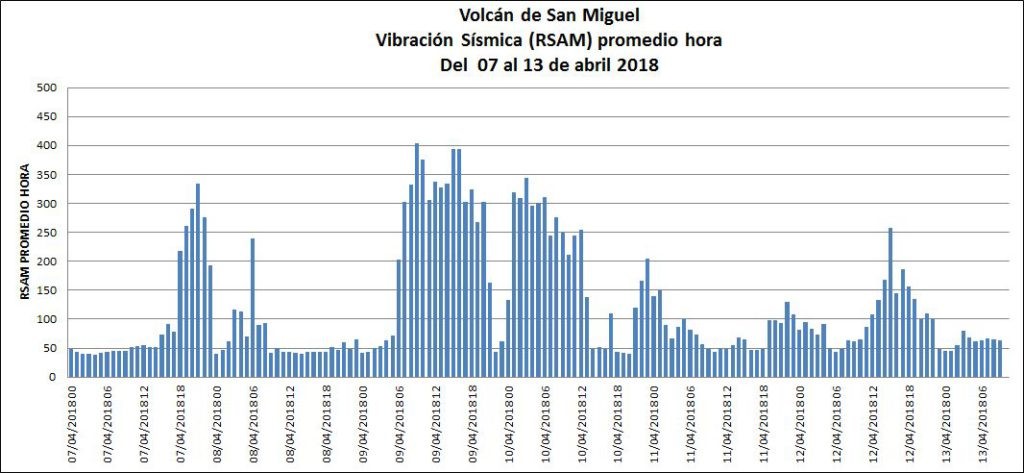 |
Figure 25. RSAM values at San Miguel during 7-13 April 2018. Courtesy of Ministero de Medio Ambiente y Recursos Naturales (MARN). |
Discrete earthquakes were detected between 13 and 17 April, and discontinuous volcanic tremor during 17-18 April was associated with weak, sporadic degassing from the central crater. Seismicity reached maximum values of 216 RSAM units in an average hour.
MARN reported that during 20-27 April volcanic tremor fluctuated between 37 and 106 RSAM units per average hour. Seismicity was low during 28 April-4 May, with RSAM between 39 and 61 units per hour.
In May MARN reported that the volcanic activity had declined compared to April. As of 18 May there was no change in volcanic activity, despite the seismic swarm that started on the night of 5 May felt in the municipalities of Chirilagua-Intipucá, 30 km SE. Average SO2 emission rates were variable during 1 January-6 May 2018 (figure 26).
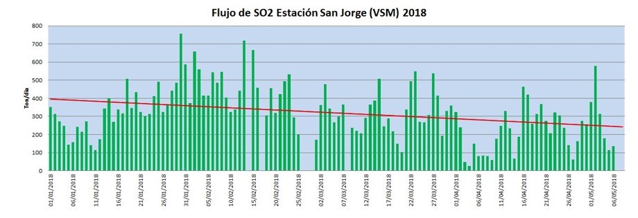 |
Figure 26. Sulfur dioxide emissions at San Miguel between from 1 January-6 May 2018. Courtesy of Ministero de Medio Ambiente y Recursos Naturales (MARN). |
SNET reported a significant increase in the number of low- and high-frequency earthquakes beneath the crater beginning on 22 May. RSAM values fluctuated between 142 and 176 units during 30 May-1 June. Webcam images on 30 May showed a small gray gas emission.
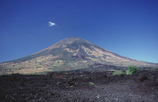
Geological Summary. The symmetrical cone of San Miguel, one of the most active volcanoes in El Salvador, rises from near sea level to form one of the country's most prominent landmarks. A broad, deep, crater complex that has been frequently modified by eruptions recorded since the early 16th century caps the truncated unvegetated summit, also known locally as Chaparrastique. Flanks eruptions of the basaltic-andesitic volcano have produced many lava flows, including several during the 17th-19th centuries that extended to the N, NE, and SE. The SE-flank flows are the largest and form broad, sparsely vegetated lava fields crossed by highways and a railroad skirting the base of the volcano. Flank vent locations have migrated higher on the edifice during historical time, and the most recent activity has consisted of minor ash eruptions from the summit crater.
Information Contacts: Servicio Nacional de Estudios Territoriales (SNET), Ministero de Medio Ambiente y Recursos Naturales (MARN), Km. 5½ Carretera a Nueva San Salvador, Avenida las Mercedes, San Salvador, El Salvador (URL: http://www.snet.gob.sv/ver/vulcanologia, http://www.marn.gob.sv/category/avisos/vulcanologia/).