Report on Copahue (Chile-Argentina) — July 2018
Bulletin of the Global Volcanism Network, vol. 43, no. 7 (July 2018)
Managing Editor: Edward Venzke.
Research and preparation by Paul Berger.
Copahue (Chile-Argentina) Phreatic explosion in March; possible ash emissions June 2018
Please cite this report as:
Global Volcanism Program, 2018. Report on Copahue (Chile-Argentina) (Venzke, E., ed.). Bulletin of the Global Volcanism Network, 43:7. Smithsonian Institution. https://doi.org/10.5479/si.GVP.BGVN201807-357090
Copahue
Chile-Argentina
37.856°S, 71.183°W; summit elev. 2953 m
All times are local (unless otherwise noted)
The most recent activity from Copahue originates in the El Agrio crater, which has permanent fumarolic activity and an acidic lake. During 2017, ash emissions began in early June, but decreased after July, although tremor and degassing with occasional ash continued for the remainder of the year (BGVN 43:01). The volcano is monitored by the Servicio Nacional de Geología y Minería (SERNAGEOMIN). This report discusses activity during January-June 2018.
According to the Oficina Nacional de Emergencia-Ministerio del Interior (ONEMI), SERNAGEOMIN reported that a hydrothermal explosion was recorded on 24 March 2018, along with increased tremor. The Alert Level was raised to Yellow (second highest level on a four-color scale); SERNAGEOMIN recommended no entry into a restricted area within 1 km of the crater. ONEMI maintained its own Alert Level of Yellow (the middle level on a three-color scale) for the municipality of Alto Biobío (25 km SW).
Based on SERNAGEOMIN information, ONEMI reported that during 1-31 March 2018 there were 83 volcano-tectonic events recorded and 204 earthquakes indicting fluid movement. Tremor levels increased on 24 March, the same day as a phreatic explosion, though by the next day it had decreased to baseline levels. Webcams recorded gas plumes rising from El Agrio crater as high as 1 km. During an overflight on 3 April, scientists observed continuous white gas plumes rising almost 400 m.
The Buenos Aires Volcanic Ash Advisory Center (VAAC) reported that on 24 June diffuse steam emissions possibly containing ash were visible in webcam views rising to an altitude of 3.6 km.
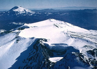
Geological Summary. Volcán Copahue is an elongated composite cone constructed along the Chile-Argentina border within the 6.5 x 8.5 km wide Trapa-Trapa caldera that formed between 0.6 and 0.4 million years ago near the NW margin of the 20 x 15 km Pliocene Caviahue (Del Agrio) caldera. The eastern summit crater, part of a 2-km-long, ENE-WSW line of nine craters, contains a briny, acidic 300-m-wide crater lake (also referred to as El Agrio or Del Agrio) and displays intense fumarolic activity. Acidic hot springs occur below the eastern outlet of the crater lake, contributing to the acidity of the Río Agrio, and another geothermal zone is located within Caviahue caldera about 7 km NE of the summit. Infrequent mild-to-moderate explosive eruptions have been recorded since the 18th century. Twentieth-century eruptions from the crater lake have ejected pyroclastic rocks and chilled liquid sulfur fragments.
Information Contacts: Oficina Nacional de Emergencia - Ministerio del Interior (ONEMI), Beaucheff 1637/1671, Santiago, Chile (URL: http://www.onemi.cl/); Servicio Nacional de Geología y Minería (SERNAGEOMIN), Observatorio Volcanológico de Los Andes del Sur (OVDAS), Avda Sta María No. 0104, Santiago, Chile (URL: http://www.sernageomin.cl/); Buenos Aires Volcanic Ash Advisory Center (VAAC), Servicio Meteorológico Nacional-Fuerza Aérea Argentina, 25 de mayo 658, Buenos Aires, Argentina (URL: http://www.smn.gov.ar/vaac/buenosaires/inicio.php).

