Report on Great Sitkin (United States) — September 2018
Bulletin of the Global Volcanism Network, vol. 43, no. 9 (September 2018)
Managing Editor: Edward Venzke.
Research and preparation by Sara Arav-Piper.
Great Sitkin (United States) Small phreatic explosions in June and August 2018; ash deposit on snow near summit
Please cite this report as:
Global Volcanism Program, 2018. Report on Great Sitkin (United States) (Venzke, E., ed.). Bulletin of the Global Volcanism Network, 43:9. Smithsonian Institution. https://doi.org/10.5479/si.GVP.BGVN201809-311120
Great Sitkin
United States
52.076°N, 176.13°W; summit elev. 1740 m
All times are local (unless otherwise noted)
Episodic recent and historic volcanic activity has been reported at Great Sitkin, located about 40 km NE of the community of Adak in the Aleutian Islands. Prior to the recent 2018 activity, the last confirmed eruption in 1974 produced at least one ash cloud that likely exceeded an altitude of 3 km (figures 1 and 2). This eruption extruded a lava dome that partially destroyed an existing dome from a 1945 eruption. Most recently, a small steam explosion was reported on 10 June 2018. In response, the Alaska Volcano Observatory (AVO) raised the Aviation Color Code (ACC) to Yellow (Advisory) from the previous Green (Normal).
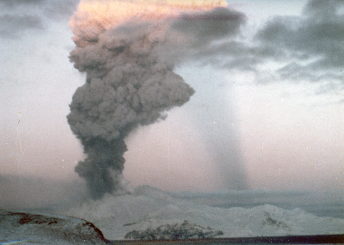 |
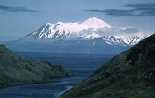
Figure 1. Eruption of Great Sitkin volcano in 1974. Photo taken from Adak Island, Alaska, located 40 km SW of the volcano. Photographer/Creator: Paul W. Roberts; courtesy of AVO/USGS (color corrected). |
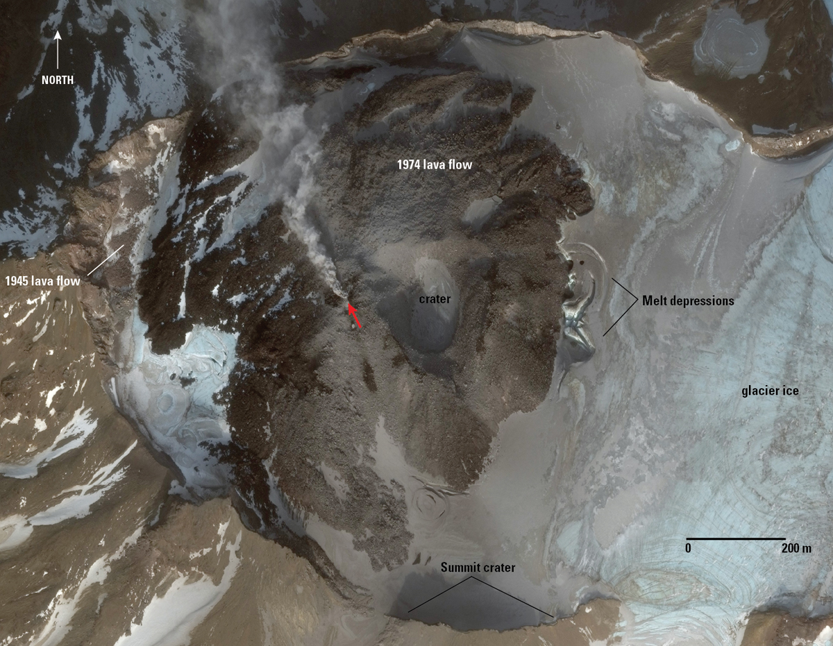 |
Figure 2. Worldview-3 satellite image of Great Sitkin on 21 November 2017 showing the crater, areas of 1974 and 1945 lava flows, and steam (indicated by the red arrow) from the reported seismic swarm and steam event ending in 2017. Photographer/Creator: Chris Waytomas; image courtesy of AVO/USGS. |
AVO had previously reported that a seismic swarm had been detected beginning in late July 2016 and continuing through December 2017. Steam from the crater was also observed during this time period, in late November 2017 (figure 2). The seismicity was characterized by earthquakes typically less than magnitude 1.0 and at depths from near the summit to 30 km below sea level. Most earthquakes were in one of two clusters, beneath the volcano's summit or just offshore the NW coast of the island. Possible explosion signals were observed in seismic data on 10 January and 21 July 2017, but no confirmed emissions were observed locally or detected in infrasound data or satellite imagery.
The most recent eruption at Great Sitkin produced a small steam explosion which was detected in seismic data at 1139 local time on 10 June 2018 (figure 3). The explosion was followed by seismic activity which began diminishing after 24 hours, and by 15-16 June had returned to background levels.
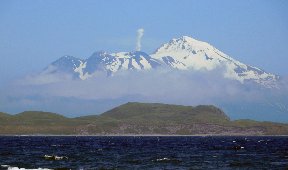 |
Figure 3. View of Great Sitkin steaming on 10 July 2018. Photographed from Adak Island, Alaska, approximately 40 km SW. Photo by Alain Beauparlant; image courtesy of AVO/USGS (color corrected). |
Due to heavy cloud cover on 10 June 2018, satellite views were obscured. Subsequent satellite data collected on 11 June showed an ash deposit on the surface of the snow extending to about 2 km SW from a vent in the summit crater (figure 4). Minor changes in the vicinity of the summit crater were observed from satellite data, including possible fumaroles north of the main crater. On 17 June an aerial photograph showed minor steaming at the vent (figure 5).
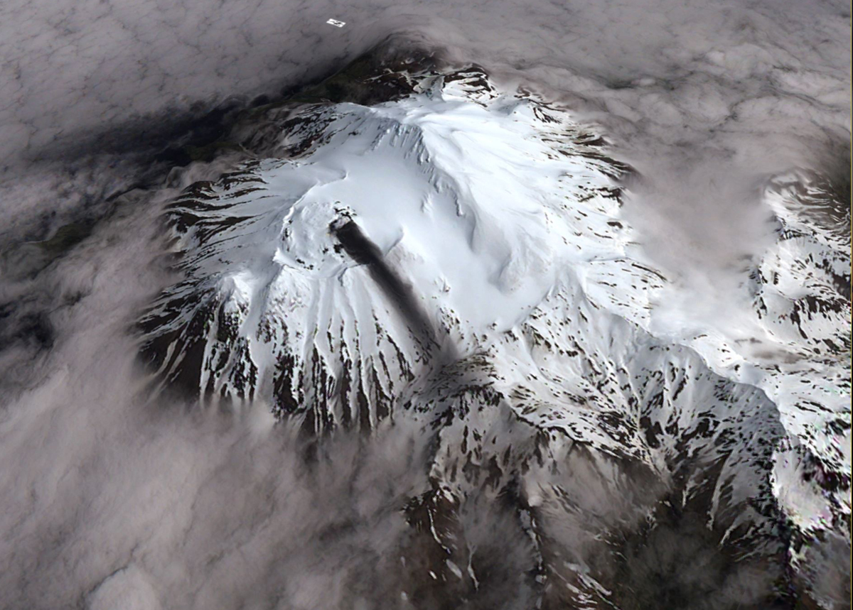 |
Figure 4. Satellite view of the Great Sitkin crater at 2300 UTC on 11 June 2018 showing an ash deposit extending for about 2 km to the SW. Ash was likely deposited during the brief explosion on 10 June 2018. Minor steaming from a vent through the 1974 lava flow is also visible in this image. View is from the southwest. Photographer/Creator: David Schneider; image courtesy of AVO/USGS. |
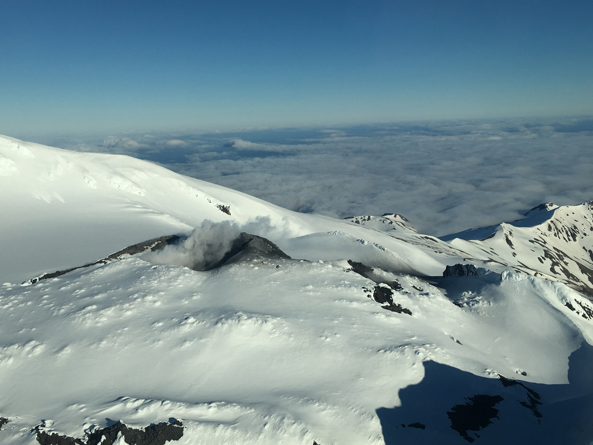 |
Figure 5. Aerial photo showing minor steaming at the summit of Great Sitkin, 17 June 2018. A small ash deposit extends SW from the vent. Photographer: Alaska Airlines Captain Dave Clum; image courtesy of AVO/USGS. |
Another small phreatic explosion was observed in seismic data at 1105 local time on 11 August. Small local earthquakes preceded the event but were not recorded following the explosion. The event is similar to three other phreatic explosions that have occurred over the past 2 years.
Geological Summary. The Great Sitkin volcano forms much of the northern side of Great Sitkin Island. A younger volcano capped by a small, 0.8 x 1.2 km ice-filled summit caldera was constructed within a large late-Pleistocene or early Holocene scarp formed by massive edifice failure that truncated an older edifice and produced a submarine debris avalanche. Deposits from this and an even older debris avalanche from a source to the south cover a broad area of the ocean floor north of the volcano. The summit lies along the eastern rim of the younger collapse scarp. Deposits from an earlier caldera-forming eruption of unknown age cover the flanks of the island to a depth up to 6 m. The small younger caldera was partially filled by lava domes emplaced in 1945 and 1974, and five small older flank lava domes, two of which lie on the coastline, were constructed along northwest- and NNW-trending lines. Hot springs, mud pots, and fumaroles occur near the head of Big Fox Creek, south of the volcano. Eruptions have been recorded since the late-19th century.
Information Contacts: Alaska Volcano Observatory (AVO), a cooperative program of a) U.S. Geological Survey, 4200 University Drive, Anchorage, AK 99508-4667 USA (URL: https://avo.alaska.edu/), b) Geophysical Institute, University of Alaska, PO Box 757320, Fairbanks, AK 99775-7320, USA, and c) Alaska Division of Geological & Geophysical Surveys, 794 University Ave., Suite 200, Fairbanks, AK 99709, USA (URL: http://dggs.alaska.gov/).