Report on Sangeang Api (Indonesia) — November 2018

Bulletin of the Global Volcanism Network, vol. 43, no. 11 (November 2018)
Managing Editor: Edward Venzke.
Research and preparation by Paul Berger.
Sangeang Api (Indonesia) Ongoing crater activity and thermal anomalies during September 2017-October 2018
Please cite this report as:
Global Volcanism Program, 2018. Report on Sangeang Api (Indonesia) (Venzke, E., ed.). Bulletin of the Global Volcanism Network, 43:11. Smithsonian Institution. https://doi.org/10.5479/si.GVP.BGVN201811-264050
Sangeang Api
Indonesia
8.2°S, 119.07°E; summit elev. 1912 m
All times are local (unless otherwise noted)
A significant increase in the number of thermal anomalies at Sangeang Api was recorded during February and June through mid-August 2017, along with a small Strombolian eruption in mid-July that generated an ash plume (BGVN 42:09). The high number of thermal anomalies continued through at least 20 October 2018. The current report summarizes activity between 1 September 2017 and 20 October 2018. The volcano is monitored by the Pusat Vulkanologi dan Mitigasi Bencana Geologi (PVMBG) and Darwin Volcanic Ash Advisory Centre (VAAC).
Based on a Volcano Observatory Notice for Aviation (VONA) from PVMBG, on 9 May 2018 a gas emission was observed at 1807 that rose to an altitude of 4,150 m and drifted W. Consequently, the Aviation Color Code was raised from unassigned to Yellow. Clear thermal satellite imagery the next day showed hot material traveling about 500 m SE out of the summit crater and continuing another 500 m down the E flank (figure 18).
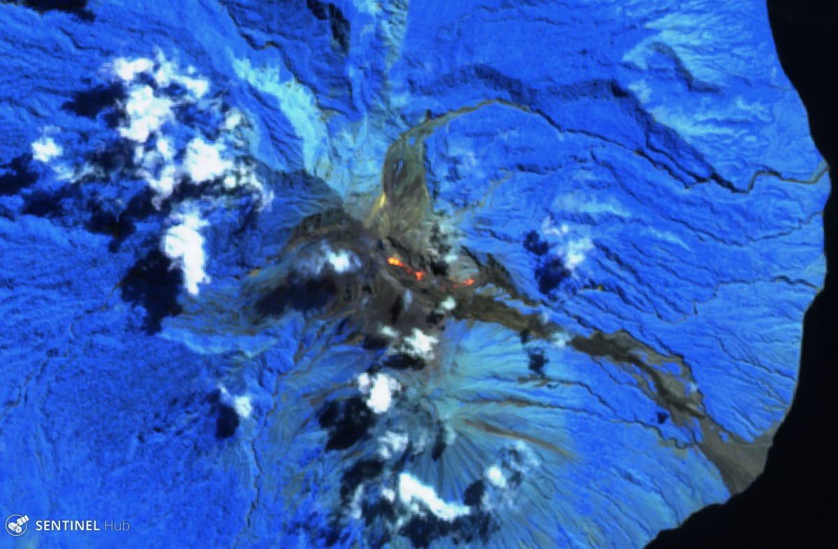 |
Figure 18. Sentinel-2 satellite image of Sangeang Api on 10 May 2018. This "Atmospheric penetration" view (bands 12, 11, and 8A) highlights hot material extending more than a kilometer from the vent in the summit crater to the SE and onto the E flank. Courtesy of Sentinel Hub. |
Based on another VONA from PVMBG, an ash emission at 1338 on 15 October 2018 rose 250 m above the summit and drifted SW, W, and NW. The VONA noted that the ash emission possibly rose higher than what a ground observer had estimated. Seismic data was dominated by signals indicating emissions as well as local tectonic earthquakes. The Aviation Color Code was raised from Yellow to Orange.
During the reporting period, MODIS satellite instruments using the MODVOLC algorithm recorded thermal anomalies between 3 and 12 days per month, many of which had multiple pixels. October 2017 had the greatest number of days with hotspots (12), while the lowest number was recorded during December 2017 through February 2018 (3-4 days per month). The vast majority of anomalies issued from the summit; a few were along the E flanks. The MIROVA (Middle InfraRed Observation of Volcanic Activity) volcano hotspot detection system, also based on analysis of MODIS data, recorded numerous hotspots during the previous 12 months through mid-October 2018, except for the second half of January 2018 (figure 19). Almost all recorded MIROVA anomalies were within 5 km of the volcano and of low to moderate radiative power.
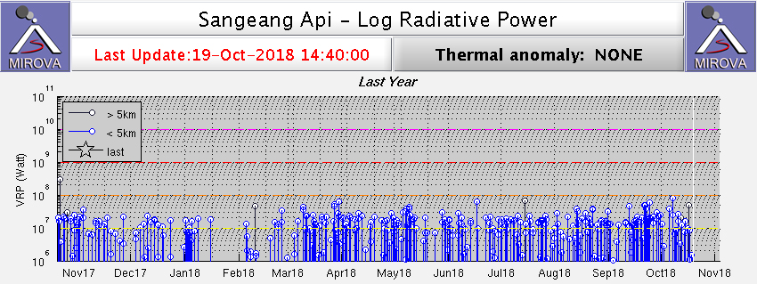 |
Figure 19. Thermal anomalies identified by the MIROVA system (Log Radiative Power) at Sangeang Api for the year ending 19 October 2018. Courtesy of MIROVA. |
Geological Summary. Sangeang Api volcano, one of the most active in the Lesser Sunda Islands, forms a small 13-km-wide island off the NE coast of Sumbawa Island. Two large trachybasaltic-to-tranchyandesitic volcanic cones, Doro Api and Doro Mantoi, were constructed in the center and on the eastern rim, respectively, of an older, largely obscured caldera. Flank vents occur on the south side of Doro Mantoi and near the northern coast. Intermittent eruptions have been recorded since 1512, most of them during in the 20th century.
Information Contacts: Pusat Vulkanologi dan Mitigasi Bencana Geologi (PVMBG, also known as Indonesian Center for Volcanology and Geological Hazard Mitigation, CVGHM), Jalan Diponegoro 57, Bandung 40122, Indonesia (URL: http://www.vsi.esdm.go.id/); Darwin Volcanic Ash Advisory Centre (VAAC), Bureau of Meteorology, Northern Territory Regional Office, PO Box 40050, Casuarina, NT 0811, Australia (URL: http://www.bom.gov.au/info/vaac/); Hawai'i Institute of Geophysics and Planetology (HIGP) - MODVOLC Thermal Alerts System, School of Ocean and Earth Science and Technology (SOEST), Univ. of Hawai'i, 2525 Correa Road, Honolulu, HI 96822, USA (URL: http://modis.higp.hawaii.edu/); MIROVA (Middle InfraRed Observation of Volcanic Activity), a collaborative project between the Universities of Turin and Florence (Italy) supported by the Centre for Volcanic Risk of the Italian Civil Protection Department (URL: http://www.mirovaweb.it/); Sentinel Hub Playground (URL: https://www.sentinel-hub.com/explore/sentinel-playground).