Report on Sarychev Peak (Russia) — November 2018
Bulletin of the Global Volcanism Network, vol. 43, no. 11 (November 2018)
Managing Editor: Edward Venzke.
Research and preparation by Sara Arav-Piper.
Sarychev Peak (Russia) Thermal anomalies, surface activity, and ash explosions during October-November 2017 and September-October 2018
Please cite this report as:
Global Volcanism Program, 2018. Report on Sarychev Peak (Russia) (Venzke, E., ed.). Bulletin of the Global Volcanism Network, 43:11. Smithsonian Institution. https://doi.org/10.5479/si.GVP.BGVN201811-290240
Sarychev Peak
Russia
48.092°N, 153.2°E; summit elev. 1496 m
All times are local (unless otherwise noted)
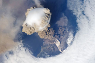
Located on Matua Island in the central Kurile Islands, Russia, Sarychev Peak (figures 19 and 20) had a significant eruption in June-July 2009 (BGVN 34:06, 35:09). Prior to this, a 1946 eruption resulted in the crater with a diameter and depth of approximately 250 m, with steep, sometimes overhanging crater walls. The N crater wall may have collapsed after a 1960 eruption, based on eyewitness accounts. A 1976 eruption included strong emissions and lava flows which resulted in a crater diameter of approximately 200 m and a floor 50-70 m below the rim. The eruption on 11-16 June 2009 encompassed more than ten large explosions, resulting in pyroclastic flows and ash plumes. The area of island covered by the June 2009 pyroclastic flows was more than 8 km2 (BGVN 34:06). Monitoring reports come from the Kamchatkan Volcanic Eruption Response Team (KVERT) and the Sakhalin Island Volcanic Eruption Response Team (SVERT).
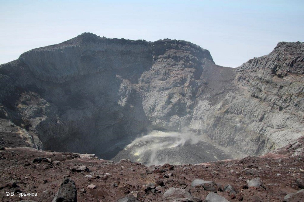 |
Figure 19. Photo looking into the crater of Sarychev Peak from the crater rim on 27 June 2017. Courtesy of V. Gurianov, Institute of Volcanology and Seismology FEB, RAS, KVERT. |
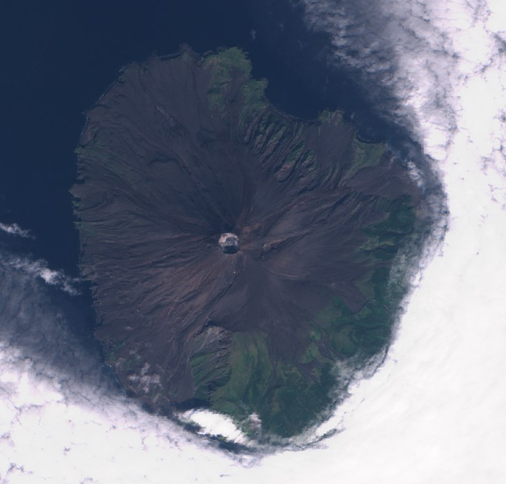 |
Figure 20. Sentinel-2 satellite image (natural color, bands 4, 3, 2) of Sarychev Peak on 8 September 2017. Courtesy of Sentinel Hub Playground. |
Thermal anomalies were noted by the NOAA Cooperative Institute for Meteorological Satellite Studies over a period of five hours on 14 October 2017 in satellite data from Terra MODIS, S-NPP VIIRS, and Himawari-8; a plume of unknown composition accompanied the anomaly. A smaller thermal anomaly was present on 12 October, but not seen the following day during favorable viewing conditions. Another thermal anomaly was reported by SVERT on 21 October; views on other days that week of 17-23 October were obscured by clouds. On 7 November gas emissions and an elongated area of snow melt and potential thermal signature was visible on the N flank of the volcano (figure 21). On 8 and 13 November steam emissions were reported by SVERT and cloud cover prevented additional observations.
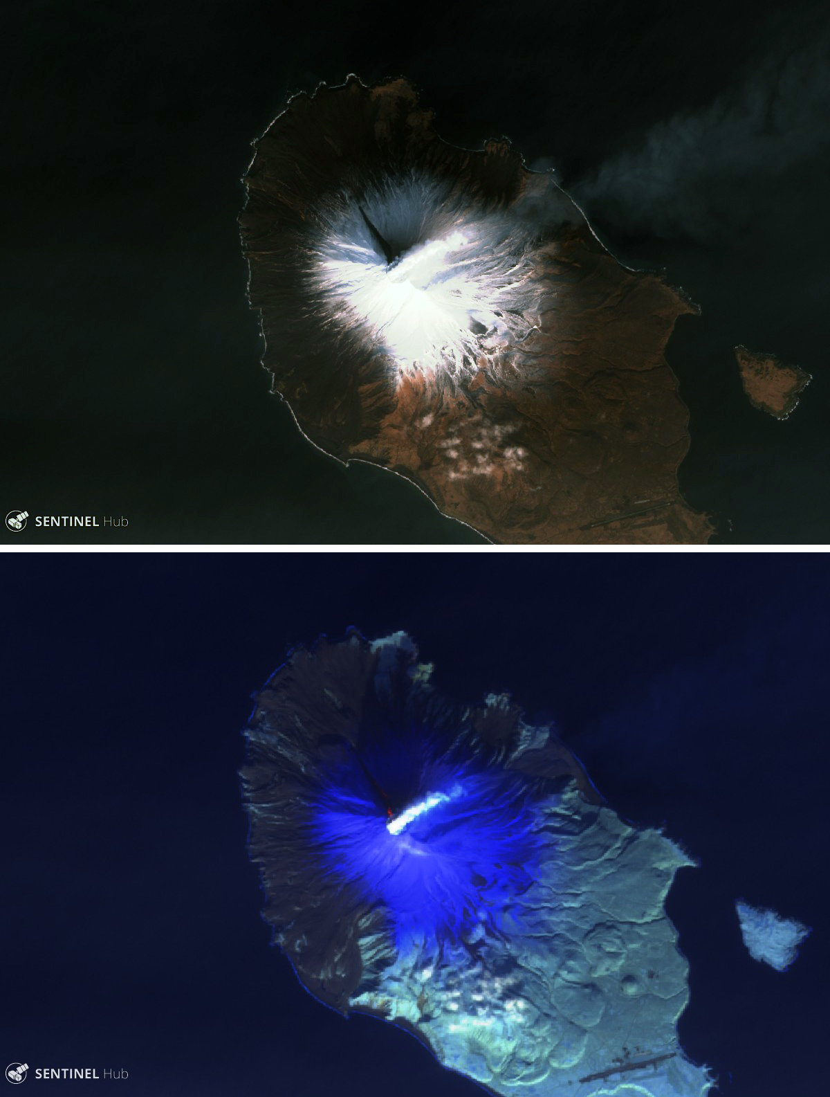 |
Figure 21. Sentinel-2 satellite images of Sarychev Peak on 7 November 2017. Top image (natural color, bands 4, 3, 2) shows a white plume rising from the summit crater and a dark area extending about 1.25 km NW on the snow-covered slopes. Bottom image (atmospheric penetration, bands 12, 11, 8A) shows hot areas (in orange) of volcano material near the summit within the dark area seen in visible imagery. Courtesy of Sentinel Hub Playground. |
The volcano was usually cloud-covered after mid-November 2017 through mid-February 2018. A small white plume seen in Sentinel-2 imagery on 20 February 2018 was not accompanied by a noticeable thermal anomaly, and the island appeared completely snow-covered. No activity of any kind was seen on the next cloud-free images taken on 4 and 11 May 2018, when the summit crater was filled with snow.
KVERT noted in a September report that there had been a thermal anomaly periodically observed after 7 May 2018. Fumarolic plumes were visible on 5 and 18 June 2018 (figure 22). Thermal anomalies were present on 8 and 11-12 September. Moderate explosions were reported during 11-15 September 2018, with ash emissions rising 3-4 km. On 14 September ash plumes drifted as far as 120 km NNE and the Aviation Color Code was raised to Orange. Explosions on 17 September generated ash plumes that rose as high as 4.5 km and drifted 21 km NE. Additional ash plumes identified in satellite images drifted 265 km E during 17-18 September. The eruption continued through 21 September, and a thermal anomaly was again visible on 22 September.
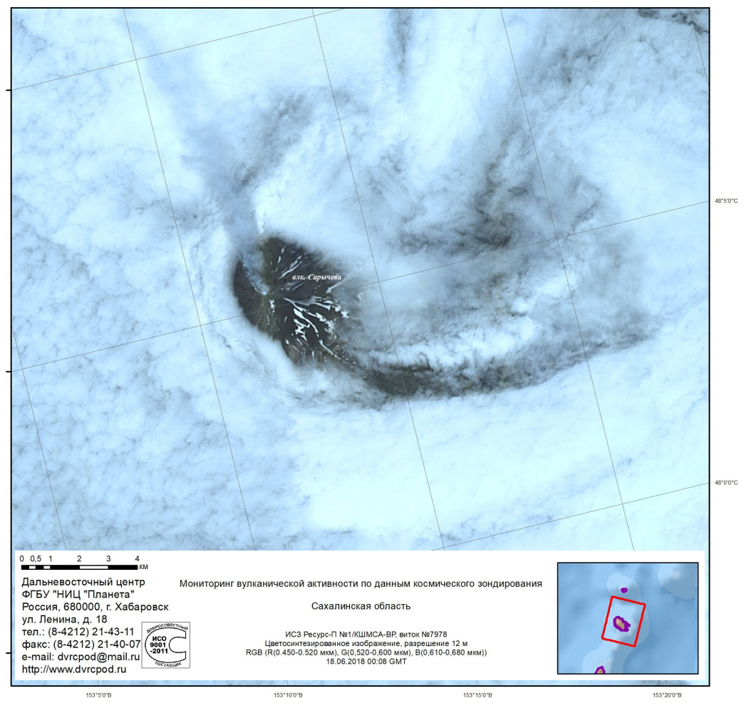 |
Figure 22. Fumarolic activity at Sarychev Peak on 18 June 2018. Courtesy of FEC SRC Planeta, Institute of Volcanology and Seismology FEB RAS, KVERT. |
Based on Tokyo VAAC data and satellite images, KVERT reported that at 1330 on 10 October 2018 an ash plume reached 1.7-2 km altitude and drifted 95 km E. SVERT reported that on 15 October an ash plume rose to 2.1 km altitude and drifted 65-70 km E. KVERT reported that a thermal anomaly was also identified in satellite images on 15 October. No further activity was seen through the end of October.
Thermal anomalies identified in MODIS data by the MIROVA system during October 2016-October 2018 occurred intermittently during the summer months each year (figure 23). However, most of those events were low-power and located several kilometers from the crater, so the heat source is unclear.
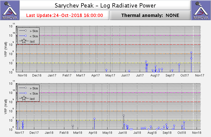 |
Figure 23. Thermal anomalies detected by the MIROVA system using MODIS data at Sarychev Peak for the year ending 18 October 2017 (top) and ending 24 October 2018 (bottom), plotted as log radiative power. Most of the events shown were located several kilometers from the summit crater. Courtesy of MIROVA. |
Geological Summary. Sarychev Peak, one of the most active volcanoes of the Kuril Islands, occupies the NW end of Matua Island in the central Kuriles. The andesitic central cone was constructed within a 3-3.5-km-wide caldera, whose rim is exposed only on the SW side. A dramatic 250-m-wide, very steep-walled crater with a jagged rim caps the volcano. The substantially higher SE rim forms the 1496 m high point of the island. Fresh-looking lava flows, prior to activity in 2009, had descended in all directions, often forming capes along the coast. Much of the lower-angle outer flanks of the volcano are overlain by pyroclastic-flow deposits. Eruptions have been recorded since the 1760s and include both quiet lava effusion and violent explosions. Large eruptions in 1946 and 2009 produced pyroclastic flows that reached the sea.
Information Contacts: Sakhalin Volcanic Eruptions Response Team (SVERT), Institute of Marine Geology and Geophysics (IMG&G) Far East Division Russian Academy of Sciences (FED RAS), 1B Science St., Yuzhno-Sakhalinsk, 693022, Russia (URL: http://www.imgg.ru/); Kamchatka Volcanic Eruptions Response Team (KVERT), Far Eastern Branch, Russian Academy of Sciences, 9 Piip Blvd., Petropavlovsk-Kamchatsky, 683006, Russia (URL: http://www.kscnet.ru/ivs/kvert/); NOAA, Cooperative Institute for Meteorological Satellite Studies (CIMSS), Space Science and Engineering Center (SSEC), University of Wisconsin-Madison, 1225 W. Dayton St. Madison, WI 53706, (URL: http://cimss.ssec.wisc.edu/); MIROVA (Middle InfraRed Observation of Volcanic Activity), a collaborative project between the Universities of Turin and Florence (Italy) supported by the Centre for Volcanic Risk of the Italian Civil Protection Department (URL: http://www.mirovaweb.it/); Sentinel Hub Playground (URL: https://www.sentinel-hub.com/explore/sentinel-playground).