Report on Planchon-Peteroa (Chile) — March 2019
Bulletin of the Global Volcanism Network, vol. 44, no. 3 (March 2019)
Managing Editor: Edward Venzke.
Edited by A. Elizabeth Crafford.
Planchon-Peteroa (Chile) New eruption begins in September 2018; continuous ash emissions and intermittent explosions December 2018-February 2019
Please cite this report as:
Global Volcanism Program, 2019. Report on Planchon-Peteroa (Chile) (Crafford, A.E., and Venzke, E., eds.). Bulletin of the Global Volcanism Network, 44:3. Smithsonian Institution. https://doi.org/10.5479/si.GVP.BGVN201903-357040
Planchon-Peteroa
Chile
35.223°S, 70.568°W; summit elev. 3977 m
All times are local (unless otherwise noted)
Planchón-Peteroa, a large basaltic to dacitic volcanic complex, lies on the remote Chile-Argentina border roughly 200 km S of Santiago, Chile. Its intermittent eruptive history has been characterized by short-lived explosive events with gas and ash plumes from active craters around the Volcán Peteroa area (figure 10). The most recent eruption, from February-June 2011, was a series of sporadic ash and gas plumes which rose as high as 5.5 km altitude and produced ashfall as far as 70 km away (BGVN 38:11). After seven years of little surface activity, a new series of ash emissions and explosive activity began in September 2018; a major seismic swarm in 2016 did not result in surface activity. Information for this report, covering through February 2019, was provided primarily by Servicio Nacional de Geología y Minería (SERNAGEOMIN), Observatorio Volcanológico de Los Andes del Sur (OVDAS) and the Buenos Aires Volcanic Ash Advisory Center (VAAC).
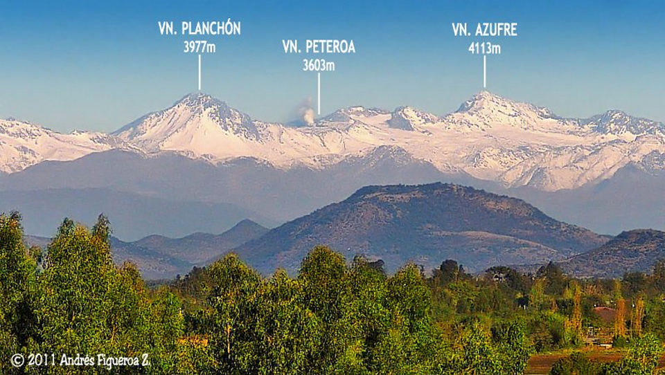 |
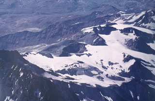
Figure 10. The Planchón-Peteroa volcanic complex was last active from February to June 2011, as seen in this image taken on 23 April 2011 from Santa Cruz de Colchagua, located 100 km NW. Image copyright by Andres Figueroa Z (HBOC), courtesy of Cumbres y Montañas de O'Higgins and used with permission from the photographer. |
Planchón-Peteroa remained quiet during 2014 and 2015. A significant seismic swarm during 2016 led SERNAGEOMIN to raise the alert level for nearly the entire year, although no surface eruptive activity took place. A smaller seismic event in 2017 also did not include surface activity. Increased emissions that included particulate material were first reported in September 2018; the first explosions with ash took place in early November 2018. Persistent emissions with dense plumes of ash began in mid-December and continued through February 2019; intermittent pulses and explosions during that time coincided with increased seismic and thermal activity.
Activity during 2014-2015. Background levels of volcano-tectonic (VT) and long-period (LP) earthquakes were reported by SERNAGEOMIN throughout 2014 and 2015. A single seismic event greater than M 3.0 was reported on 11 May 2014, located within 1 km of the crater. Inclinometer, SO2, and thermal data all indicated no significant changes during the period. During March-July 2015 sporadic fumaroles were observed rising less than 200 m from the active crater.
Activity during 2016. An increase in LP seismic events from a few to several hundred per month was noted by SERNAGEOMIN beginning in January 2016. As a result, they increased the Alert Level of the volcano from Green to Yellow on 22 January. The webcam revealed degassing of mainly water vapor reaching close to 200 m above the active crater. During the first two weeks of February 2016 the number of LP events increased ten-fold from 328 in January to 3,634; all the events were smaller than M 1.1. The rate of LP seismicity increased further during the last two weeks of February to 7,301 events, and the steam plumes reached 400 m above the crater. LP seismicity remained high during March with 9,627 measured events; similar numbers of events were sustained through May 2016 (figure 11).
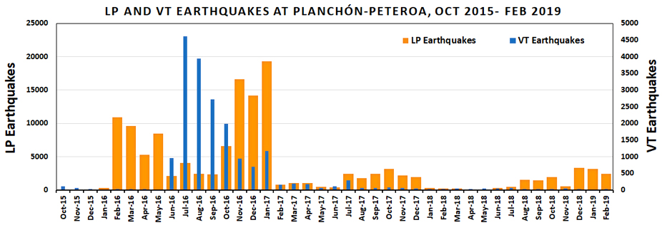 |
Figure 11. Seismicity at Planchón-Peteroa from October 2015 through February 2019. Two periods of increased seismicity were detected prior to 2018, although the only observed changes in surface activity were slight increases in the height and intensity of the steam plumes. The first event, from January 2016-January 2017 included periods with very high numbers of both VT and LP events at different times during the year. The second period of increased seismicity was from July to December 2017; the numbers of VT events were elevated briefly in July, but the LP event numbers remained elevated through December. The number of LP seismic events began increasing again in July 2018; the first particulate emissions were noted in September, and significant explosions with ash began in November 2018. Note two vertical axes on graph, the left represents numbers of LP seismic events in orange, the right represents the number of VT seismic events in blue. Data courtesy of SERNAGEOMIN. |
LP seismicity decreased substantially to only 470 events during the first two weeks of June 2016, leading SERNAGEOMIN to reduce the Alert Level to Green. However, during the second half of June a spike in the VT events from 8 during the first half of the month to 944 caused authorities to raise the Alert Level back to Yellow. This increase in VT seismic events was also accompanied by an increase in the number and spectral frequency of the LP events. They changed from having dominant frequencies between 1.9 and 2 Hz to 4-5 Hz, with a location that moved closer to the crater zone than before, and occurred at depths of around 1.5 km. On 28 June a M 3.4 VT event occurred 4.3 km NNE of the crater at a depth of 4.8 km. LP events numbered between 2,100 and 4,100 events monthly during June-September.
VT seismic events increased to their highest levels of 2016 during July (4,609 events) before beginning a gradual decline through the end of the year, ending with about 700 events in December (figure 11). A strong steam plume rose 550 m above the crater on 4 July 2016 and was accompanied by 400 VT events. The number of LP events increased significantly for the second time during the year beginning in October and remained over 14,000 events through January 2017. Three seismic events with local magnitude (ML) greater than M 3.0 were recorded on 7, 12, and 16 October; the locations of the events were approximately 3 km NNW at an average depth of 5 km. A M 3.4 event was recorded on 19 November. Low-level steam plumes did not rise more than 200 m above the crater for the remainder of the year. SERNAGEOMIN installed two new seismic stations, on 29 November and 15 December 2016.
Activity during 2017. Levels of both VT and LP seismic events declined during January-May 2017. A M 3.5 VT earthquake on 19 February was located 3.7 km NNW of the crater and 4.5 km deep. On 28 March, a M 3.6 event occurred in a similar location. Steam plumes occasionally rose as high as 200 m during the period. SERNAGEOMIN lowered the Alert Level to Green on 17 May 2017 based on the gradual decrease in seismicity to baseline levels accompanied by little to no surface activity.
A seismic swarm of 39 events on 15 June was located 14 km SE and 8-10 km deep. VT seismic events during the first half of July 2017 were located 4-7 km deep under the summit craters and included a M 4.0 event on 8 July. An increase in both VT and LP seismicity in early July led SERNAGEOMIN to raise the Alert Level to Yellow on 10 July (figure 11). The monthly number of VT events dropped below 100 in August and remained low for the rest of the year. A M 3.5 VT event was reported on 5 November, located 6.5 km E and 6 km deep. On 14 November seismometers recorded a 30-minute tremor event. A brief increase in degassing began on 23 November; steam plumes reached 600 m the next day but returned to less than 150 m by the end of the month. SERNAGEOMIN lowered the Alert Level to Green in mid-December 2017 as a result of decreased surface and seismic activity.
Activity during 2018. Low levels of surface and seismic activity persisted into early June 2018. Steam plumes rose no more than 500 m above the crater, numbers of VT events remained low, and the numbers of LP events decreased steadily. In mid-May the amplitude of continuous tremor events began to increase. The frequency of the tremor events had been around 1-2 Hz earlier in the year, but beginning on 21 June they increased to around 5 Hz; this was accompanied by an oscillating amplitude seismic signal referred to as "banded tremor." SERNAGEOMIN interpreted the increase in amplitude and the banded tremor as an indication of increased heat in the system, and as a result raised the Alert Level to Yellow on 6 July 2018. The number of LP seismic events increased steadily beginning in June, along with the amplitude of the seismic events, although there were no apparent changes in surface activity (figure 12). Weak thermal anomalies were first detected in satellite data in mid-August. SERNAGEOMIN noted that the locations of the seismic events were migrating closer to the crater, and the depths were shallowing from June to August 2018.
 |
Figure 12. No surface activity was seen at Planchón-Peteroa on 11 July 2018; SERNAGEOMIN had raised the Alert Level to Yellow from Green a few days earlier due to increased seismicity. Photo from SERNAGEOMIN webcam located about 10 km W. Courtesy of SERNAGEOMIN. |
SERNAGEOMIN first reported the presence of particulate material in the persistent degassing from the active crater on 21 September 2018, noting that the degassing steam turned "slightly gray" but plumes did not rise more than 600 m above the crater. Mostly-white emissions continued during October, although they specifically mentioned emissions of low-intensity particulate material observed during 13-15 October, rising 600 m above the crater. Three MIROVA thermal alerts appeared on 14 October, the first over 1 MW to be recorded (figure 13). During the second half of October, SERNAGEOMIN noted persistent mostly-white degassing in the webcam that rose up to 700 m above the crater. They also reported webcam images in the second half of October that showed ash emissions rising a short distance above the crater, generally drifting SE, although they did not specify certain dates
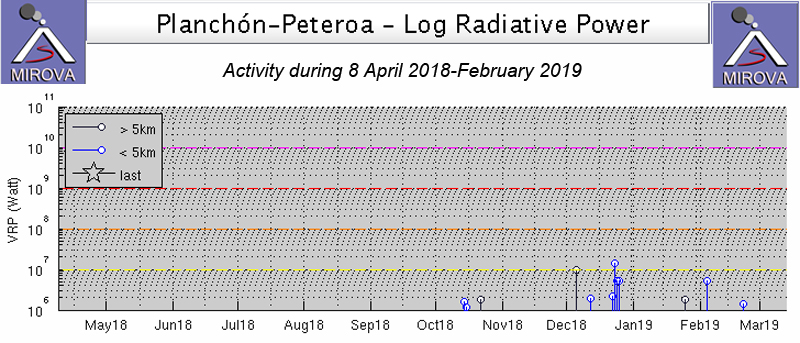 |
Figure 13. A graph of satellite thermal data by the MIROVA project from 8 April 2018 through February 2019 indicates that thermal anomalies were first reported in mid-October 2018; this corresponds with SERNAGEOMIN's observations of emissions containing significant quantities of particular material. Increased thermal activity during December 2018 and February 2019 corresponded with reports of increased explosive activity and ash emissions. Courtesy of MIROVA. |
SERNAGEOMIN reported an explosion with an ash emission visible in the webcam on 7 November 2018; they reported the plume height at about 1,000 m above the crater (figure 14). The Buenos Aires VAAC reported the ash plume drifting SE visible in satellite imagery at 4.3 km altitude. Low-altitude ash emissions were observed in the webcam multiple additional times during November. In a special report issued on 7 December, SERNAGEOMIN reported a 1,300-m-high ash emission that dispersed ESE. The Buenos Aires VAAC reported continuous ash emissions beginning on 14 December that lasted through the rest of the month (figure 15).
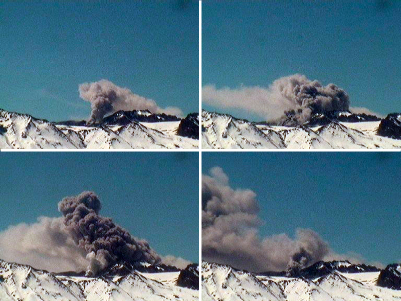 |
Figure 14. A webcam located a few kilometers W of Peteroa captured these images of the ash plume released on 7 November 2018. Courtesy of SERNAGEOMIN. |
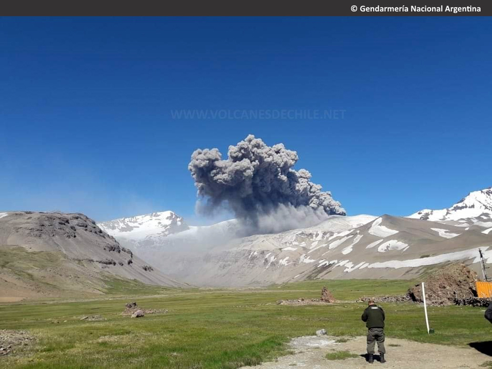 |
Figure 15. An ash cloud from Planchón-Peteroa was photographed from Paso Vergara on the Chile/Argentina border 5 km NE on 14 December 2018; the ash dispersed to the SE. Courtesy of Volcanes de Chile and SEGEMAR (Servicio Geológico Minero Argentino), copyright by Gendarmeria Nacional Argentina. |
Plumes generally drifted SE at 4.6-4.9 km altitude during December, with occasional stronger puffs that were reported as high as 5.8 km altitude (figure 16). On 16 December the webcam recorded high-intensity pulsating ash emissions that drifted 20 km SE. Incandescence was visible around the crater that night. Webcam images showed dark gray plumes during the second half of December, suggesting a high concentration of ash; the pulsating nature of the emissions was observed in the webcam again during 24-27 December, reaching 1,600 m above the crater. Multiple thermal alerts were reported during the second half of the month.
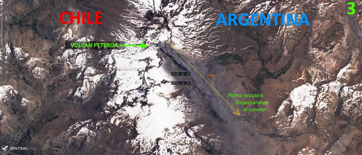 |
Figure 16. Volcanes de Chile annotated this 15 December 2018 Sentinel-2 satellite image showing the ash plume from Planchón-Peteroa drifting SE into Argentina. Courtesy of Sentinel Hub and Volcanes de Chile. |
Activity during January-February 2019. Dense ash plumes were reported daily during January and February 2019 by both SERNAGEOMIN and the Buenos Aires VAAC; plumes heights were generally between 400 m and 1 km above the active crater (figure 17). Higher plumes that reached 2 km above the crater and drifted E were reported on 1 and 3 February (figure 18). SERNAGEOMIN noted that the first of these events was accompanied by an increase in very low frequency seismic activity (VLP).
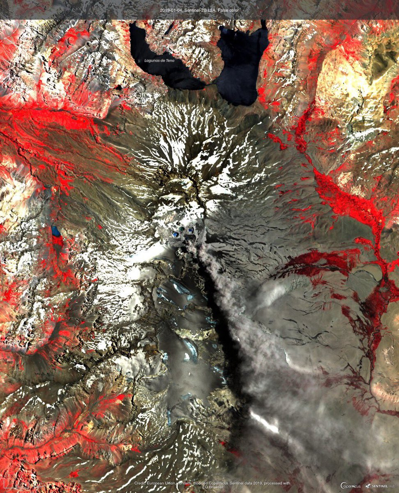 |
Figure 17. Dense ash plumes drifted SE from Planchón-Peteroa on 4 January 2019 as seen in this false-color Sentinel-2B satellite image. Courtesy of Sentinel Hub and Volcanes de Chile. |
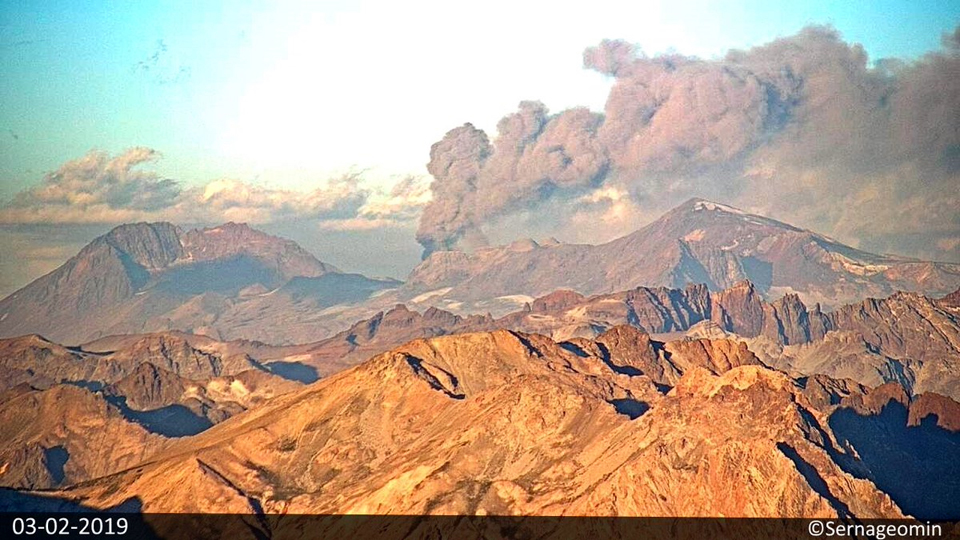 |
Figure 18. Volcanes de Chile captured this image of a dense ash plume drifting SE over Argentina from the SERNAGEOMIN webcam located about 10 km W of Planchón-Peteroa on 3 February 2018. Courtesy of Volcanes de Chile and SERNAGEOMIN. |
Satellite-based SO2 instruments also detected a significant gas plume on 3 February (figure 19). SERNAGEOMIN reported a tremor signal on 14 February 2019 associated with a dense ash plume that rose to 2 km above the summit and drifted NE. Webcam images during the second half of February showed constant degassing; gray plumes drifted mostly SE about 2 km above the summit (figure 20).
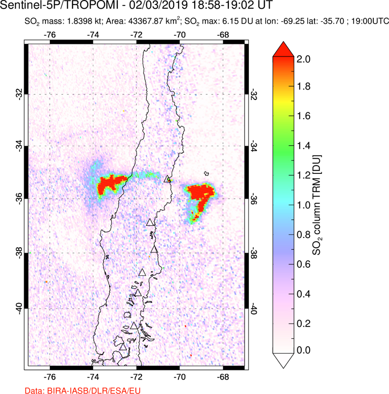 |
Figure 19. The TROPOMI instrument on the Sentinel-5P satellite recorded significant SO2 plumes drifting both E and W of Planchón-Peteroa on 3 February 2019; SERNAGEOMIN reported dense ash emissions the same day. Courtesy of NASA Goddard Space Flight Center. |
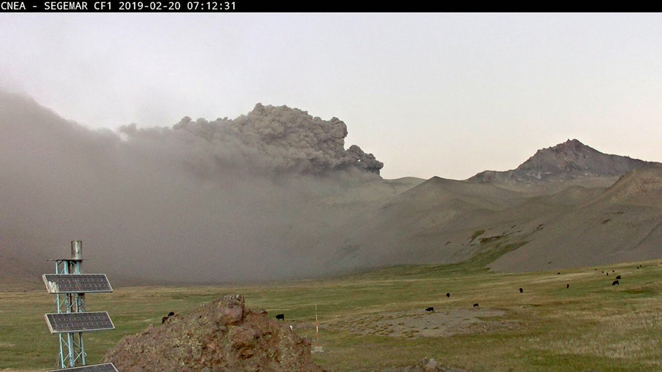 |
Figure 20. Explosive activity at Planchón-Peteroa was recorded in Paso Vergara on the Chile/Argentina border 5 km NE on 20 February 2019 at the SEGEMAR CNEA webcam. Courtesy of SEGEMAR (Servicio Geológico Minero Argentino) and Felipe Aguilera Volcanes. |
Geological Summary. Planchón-Peteroa is an elongated complex volcano along the Chile-Argentina border with several overlapping calderas. Activity began in the Pleistocene with construction of the basaltic andesite to dacitic Volcán Azufre, followed by formation of the basaltic and basaltic andesite Volcán Planchón, 6 km N. About 11,500 years ago much of Azufre and part of Planchón collapsed, forming the massive Río Teno debris avalanche, which traveled 95 km to reach Chile's Central Valley. Subsequently, Volcán Planchón II was formed. The youngest volcano, andesitic and basaltic andesite Volcán Peteroa, consists of scattered vents between Azufre and Planchón, and and contains a small steaming crater lake. Reported eruptions from the complex have been dominantly explosive, although lava flows were emplaced in 1837 and 1937.
Information Contacts: Servicio Nacional de Geología y Minería (SERNAGEOMIN), Observatorio Volcanológico de Los Andes del Sur (OVDAS), Avda Sta María No. 0104, Santiago, Chile (URL: http://www.sernageomin.cl/); Buenos Aires Volcanic Ash Advisory Center (VAAC), Servicio Meteorológico Nacional-Fuerza Aérea Argentina, 25 de mayo 658, Buenos Aires, Argentina (URL: http://www.smn.gov.ar/vaac/buenosaires/inicio.php); MIROVA (Middle InfraRed Observation of Volcanic Activity), a collaborative project between the Universities of Turin and Florence (Italy) supported by the Centre for Volcanic Risk of the Italian Civil Protection Department (URL: http://www.mirovaweb.it/); NASA Goddard Space Flight Center (NASA/GSFC), Global Sulfur Dioxide Monitoring Page, Atmospheric Chemistry and Dynamics Laboratory, 8800 Greenbelt Road, Goddard, Maryland, USA (URL: https://so2.gsfc.nasa.gov/); Servicio Geológico Minero Argentino (SEGEMAR), Av. General Paz 5445 (colectora), Parque Tecnológico Miguelete, Edificio 14 y Edificio 25, San Martín (B1650 WAB) (URL: http://www.segemar.gov.ar/); Sentinel Hub Playground (URL: https://www.sentinel-hub.com/explore/sentinel-playground); Cumbres y Montañas de O'Higgins (URL: https://www.facebook.com/cymohiggins/); Volcanes de Chile (URL: https://www.volcanesdechile.net/, Twitter: @volcanesdechile); Felipe Aguilera Volcanes (Twitter: @FelipeVolcanes, URL: https://twitter.com/FelipeVolcanes).