Report on Merapi (Indonesia) — April 2019

Bulletin of the Global Volcanism Network, vol. 44, no. 4 (April 2019)
Managing Editor: Edward Venzke.
Edited by A. Elizabeth Crafford.
Merapi (Indonesia) Dome appears at summit on 12 August 2018; grows to 447,000 m3 by late March 2019
Please cite this report as:
Global Volcanism Program, 2019. Report on Merapi (Indonesia) (Crafford, A.E., and Venzke, E., eds.). Bulletin of the Global Volcanism Network, 44:4. Smithsonian Institution. https://doi.org/10.5479/si.GVP.BGVN201904-263250
Merapi
Indonesia
7.54°S, 110.446°E; summit elev. 2910 m
All times are local (unless otherwise noted)
Merapi volcano in central Java, Indonesia (figure 69), has a lengthy history of major eruptive episodes. Activity has included lava flows, pyroclastic flows, lahars, Plinian explosions with heavy ashfall, incandescent block avalanches, and dome growth and destruction. Fatalities from these events were reported in 1994, 2006, and during a major event in 2010 (BGVN 36:01) where hundreds were killed and hundreds of thousands of people were evacuated. Renewed phreatic explosions in May 2018 cancelled airline fights and generated significant SO2 plumes in the atmosphere. The volcano then remained quiet until an explosion on 11 August 2018 marked the beginning of the growth of a new lava dome. The period June 2018 through March 2019 is covered in this report with information provided primarily by Balai Penyelidikan dan Pengembangan Teknologi Kebencanaan Geologi (BPPTKG), the Center for Research and Development of Geological Disaster Technology, a branch of PVMBG, which monitors activity specifically at Merapi.
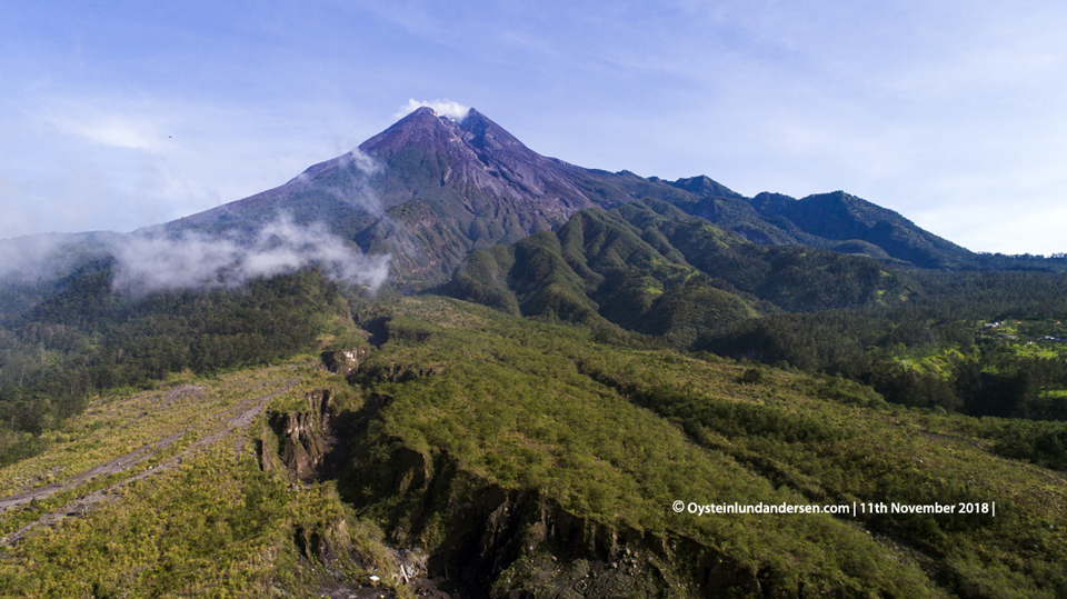 |
Figure 69. A drone aerial photo of Merapi taken on 11 November 2018 shows the Gendol river drainage in the foreground and the upper part that is often referred to as Bebeng. Pyroclastic flows descended through this drainage in both 2006 and 2010. Courtesy of Øystein Lund Andersen. |
The first sign of renewed activity at Merapi came with an explosion and the appearance of a lava dome at the summit on 12 August 2018. The growth rate of the dome fluctuated between August 2018 and January 2019, with a low rate of 1,000 m3/day in late September to a high of 6,200 m3/day in mid-October. By mid-December the dome was large enough to send block avalanches down the Kali Gendol ravine on the SSE flank. The rate of dome growth declined rapidly during January 2019, when most of the new lava moved down the ravine in numerous block avalanches. By late March 2019 the dome had reached 472,000 m3 in volume and block avalanches were occurring every few days.
After the eruptive events between 11 May and 1 June 2018, seismicity fluctuated at levels slightly above normal during June and July, with the highest levels recorded on 18 and 29 July. A VONA on 3 June reported a plume of steam that rose 800 m above the summit; for the rest of June the plume heights gradually decreased to a maximum of 400 m by the third week. During July steam plume heights varied from 30 to 350 m above the summit.
On 1 August 2018 an explosion was heard at the Babadan Post. An explosion on 11 August was heard by residents of Deles on the SE flank. Photos taken in a survey by drone the following day indicated the presence of new material in the middle of the 2010 dome fracture (figure 70). The presence of a new lava dome was confirmed with a site visit on 18 August 2018. The dome was 55 m long and 25 m wide, and about 5 m below the 2010 dome surface (figure 71). As of 23 August, the volume of the dome was 23,000 m3, growing at an average rate of 2,700 m3/day. By the end of the month the volume was estimated to be 54,000 m3 with a growth rate of 4,000 m3/day (figure 72). Throughout the month, persistent steam plumes rose 50-200 m above the summit.
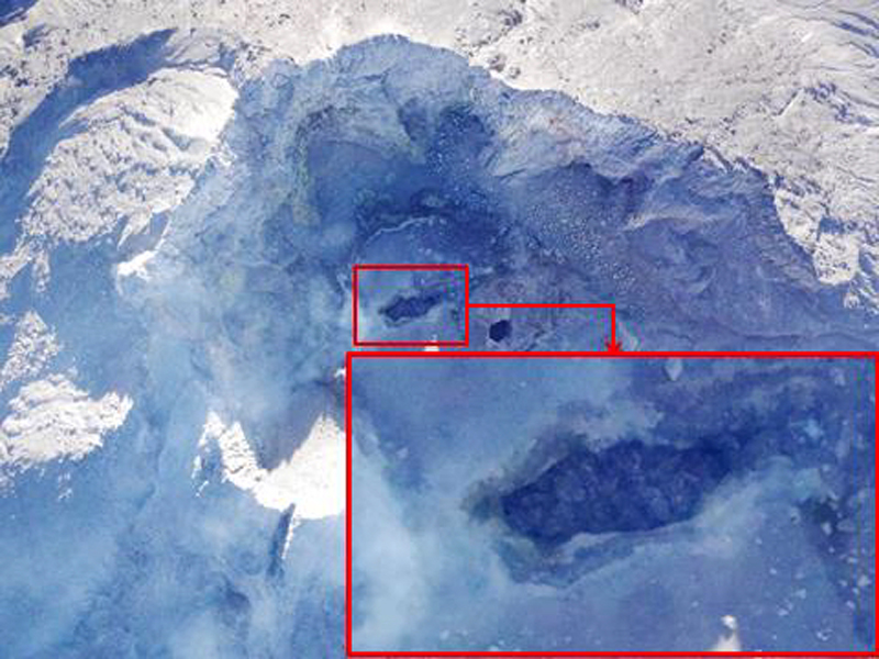 |
Figure 70. The first sign of new dome growth at Merapi appeared in this drone photo taken on 12 August 2018. Courtesy of BPPTKG (Siaran Pers 18 Agustus 2018 Pukul 17:00 WIB, Press Release 18 August 2018, 1700 local time). |
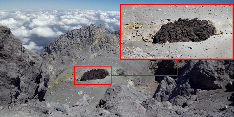 |
Figure 71. The new dome at the summit of Merapi on 18 August 2018. Courtesy of BPPTKG (Siaran Pers 18 Agustus 2018 Pukul 17:00 WIB, Press Release 18 August 2018, 1700 local time). |
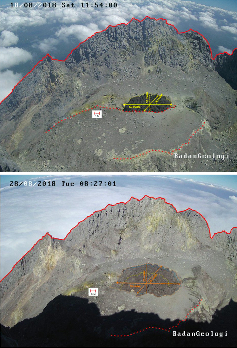 |
Figure 72. A comparison of the dome on 18 (top) and 28 (bottom) August 2018 at Merapi taken from the Puncak webcam on the N flank. By the end of August 2018, the dome size was about 54,000 m3. Courtesy of BPPTKG (posted via Twitter on 27 August 2018). |
During September-November 2018 the summit dome grew at varying rates from 1,000 to 6,200 m3/day (table 22). At the beginning of September its volume was 54,000 m3; it had reached 329,000 m3 by the end of November (figure 73). Steam plumes in September rose from 100 to 450 m above the summit. They were lower in October, rising only 50-100 m high. During November they rose 100 to400 m above the summit. Intermittent seismic activity remained above background levels. By mid-November, the growth of the dome was clearly visible from the ground 4.5 km S of the summit (figure 74).
Table 22. The volume and growth rate of the lava dome at Merapi was measured weekly from late August 2018 through January 2019. Data courtesy of BPPTKG Merapi weekly reports.
| Date | Size (m3) | Rate (m3 / day) |
| 23 Aug 2018 | 23,000 | 2,700 |
| 30 Aug 2018 | 54,000 | 4,000 |
| 06 Sep 2018 | 82,000 | 3,900 |
| 13 Sep 2018 | 103,000 | 3,000 |
| 20 Sep 2018 | 122,000 | 3,000 |
| 27 Sep 2018 | 129,000 | 1,000 |
| 04 Oct 2018 | 135,000 | 1,000 |
| 11 Oct 2018 | 160,000 | 3,100 |
| 18 Oct 2018 | 201,000 | 6,200 |
| 21 Oct 2018 | 219,000 | 6,100 |
| 31 Oct 2018 | 248,000 | 2,900 |
| 07 Nov 2018 | 273,000 | 3,500 |
| 14 Nov 2018 | 290,000 | 2,400 |
| 21 Nov 2018 | 308,000 | 2,600 |
| 29 Nov 2018 | 329,000 | 2,500 |
| 06 Dec 2018 | 344,000 | 2,200 |
| 13 Dec 2018 | 359,000 | 2,200 |
| 19 Dec 2018 | 370,000 | 2,000 |
| 27 Dec 2018 | 389,000 | 2,300 |
| 03 Jan 2019 | 415,000 | 3,800 |
| 10 Jan 2019 | 439,000 | 3,400 |
| 16 Jan 2019 | 453,000 | 2,300 |
| 22 Jan 2019 | 461,000 | 1,300 |
| 29 Jan 2019 | 461,000 | -- |
| 07 Feb 2019 | 461,000 | -- |
| 14 Feb 2019 | 461,000 | -- |
| 21 Feb 2019 | 466,000 | -- |
| 05 Mar 2019 | 470,000 | -- |
| 21 Mar 2019 | 472,000 | -- |
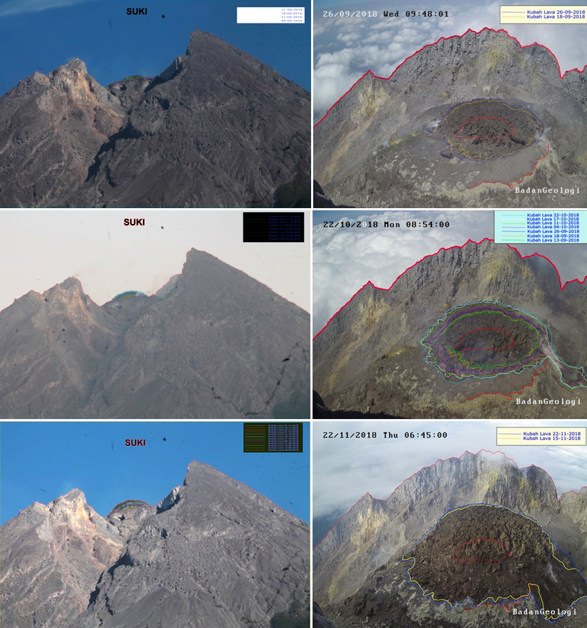 |
Figure 73. Images from September-November 2018 show the growth of the lava dome at the summit of Merapi. In each pair the left image is from the Deles webcam, and the right image is from the Puncak webcam on the same date. Top: 26 September 2018, left growth lines show change from 8 to 27 September, from 18 to 26 September on right; Middle: 22 October 2018, both sets of growth lines are from 13 September to 22 October; Bottom: 22 November 2018, left growth lines are from mid-September to 21 November and right growth lines are 15 and 22 November. In each Puncak image the red outline at the center is the dome outline on 18 August 2018. Courtesy of BPPTKG, from weekly reports of Merapi activity, 21-27 September, 19-25 October, and 16-22 November 2018. |
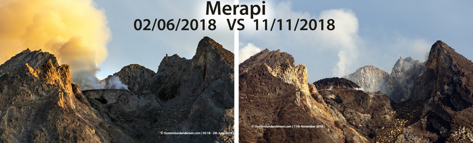 |
Figure 74. A comparison of the crater area of Merapi on 2 June 2018 (left) and 11 November 2018 (right). The new dome is clearly visible in the later photo. The images were taken about 4.5 km S of the summit. Persistent gas emissions rose from both the new dome and around the summit crater. Courtesy of Øystein Lund Andersen. |
The lava dome continued to grow during December 2018, producing steam plumes that rose 50-200 m. As the height of the dome increased, block avalanches began descending into the upper reaches of Kali Gendol ravine on the SSE flank. Avalanches on 16 and 19 December reached 300 m down the drainage; on 21 December a larger avalanche lasted for 129 seconds and traveled 1 km based on the duration of the seismic data (figure 75). By the end of December BPPTKG measured the volume of the dome as 389,000 m3.
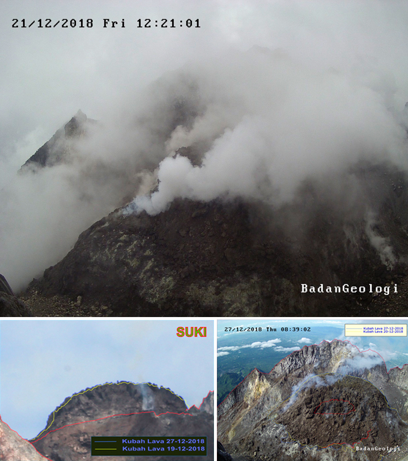 |
Figure 75. Steam and gas from a recent block avalanche rose from the edge of the new dome at Merapi on 21 December 2018 (top). By the end of December BPPTKG measured the volume of the dome as 389,000 m3. Top image from BPPTKG press release of 21 December 2018; bottom images from the weekly Merapi Mountain activities report of 21-27 December. Courtesy of BPPTKG. |
The rate of dome growth declined steadily during January 2019, and by the third week most of the lava extrusion was collapsing as block avalanches into the upper part of Kali Gendol, and dome growth had slowed. Steam plumes rose 50-450 m during the month. In spite of slowing growth, a comparison of the dome size between 11 November 2018 and 13 January 2019 indicated an increase in volume of over 150,000 m3 of material (figure 76). Incandescence at the dome and in the block avalanches was visible at night when the summit was clear (figures 77 and 78). Three block avalanches occurred during the evening of 29 January; the first traveled 1.4 km, the second 1.35 km, and the third 1.1 km down the ravine; each one lasted for about two minutes. By the end of January the size of the dome was reported by BPPTKG to be about 461,000 m3.
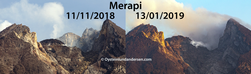 |
Figure 76. A comparison of the dome growth at Merapi from 11 November 2018 to 13 January 2019 showed an increase in volume of over 150,000 m3 according to Indonesian authorities (BPPTKG), as well as the accumulation of debris as material fell down the ravine. Courtesy of Øystein Lund Andersen. |
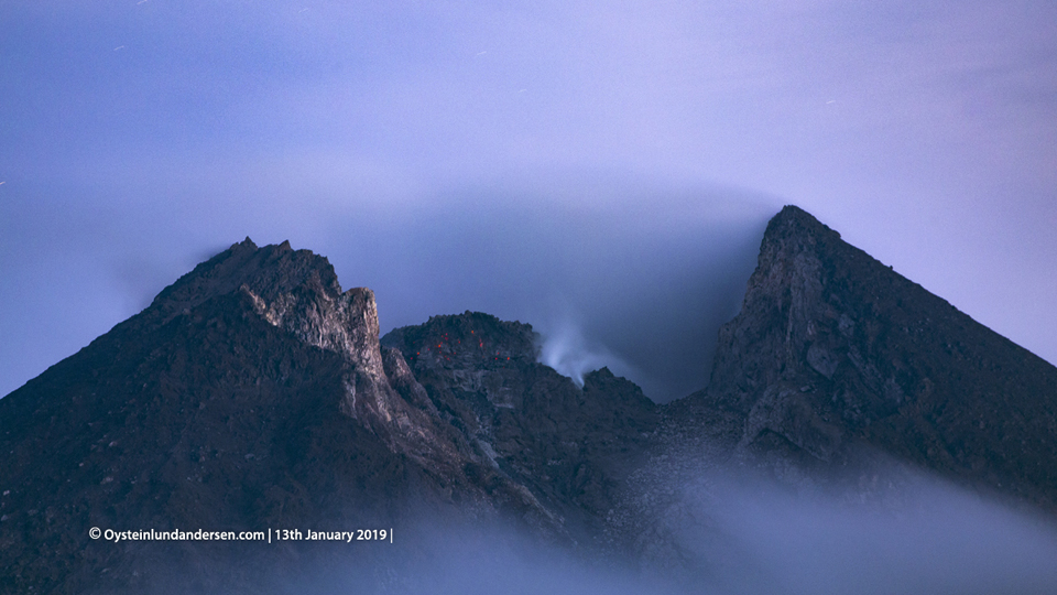 |
Figure 77. Incandescence appeared at the growing dome at the summit of Merapi late on 13 January 2019. Courtesy of Øystein Lund Andersen. |
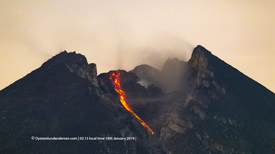 |
Figure 78. Incandescent blocks from the growing dome at Merapi traveled several hundred meters down Kali Gendol on 14 January 2019. Courtesy of Øystein Lund Andersen. |
Numerous block avalanches were observed during February 2019 as almost all of the lava extrusion was moving down the slope. Multiple avalanches were reported on 7, 11, 18, 25, and 27 February, with traveling distances ranging from 200 to 2,000 m. Steam plumes did not rise more than 375 m during the month. By the end of February, the dome had only grown slightly to 466,000 m3. Seventeen block avalanches were reported during March 2019; they traveled distances ranging from 500 to 1,900 m down the Kali Gendol ravine. A drone measurement on 5 March determined the volume of the dome to be 470,000 m3; it was only 2,000 m3 larger when measured again on 21 March.
Geological Summary. Merapi, one of Indonesia's most active volcanoes, lies in one of the world's most densely populated areas and dominates the landscape immediately north of the major city of Yogyakarta. It is the youngest and southernmost of a volcanic chain extending NNW to Ungaran volcano. Growth of Old Merapi during the Pleistocene ended with major edifice collapse perhaps about 2,000 years ago, leaving a large arcuate scarp cutting the eroded older Batulawang volcano. Subsequent growth of the steep-sided Young Merapi edifice, its upper part unvegetated due to frequent activity, began SW of the earlier collapse scarp. Pyroclastic flows and lahars accompanying growth and collapse of the steep-sided active summit lava dome have devastated cultivated lands on the western-to-southern flanks and caused many fatalities.
Information Contacts: Balai Penyelidikan dan Pengembangan Teknologi Kebencanaan Geologi (BPPTKG), Center for Research and Development of Geological Disaster Technology (URL: http://merapi.bgl.esdm.go.id/, Twitter: @BPPTKG); Pusat Vulkanologi dan Mitigasi Bencana Geologi (PVMBG, also known as Indonesian Center for Volcanology and Geological Hazard Mitigation, CVGHM), Jalan Diponegoro 57, Bandung 40122, Indonesia (URL: http://www.vsi.esdm.go.id/); Øystein Lund Andersen (Twitter: @OysteinLAnderse, https://twitter.com/OysteinLAnderse, URL: https://www.oysteinlundandersen.com/).