Report on Ulawun (Papua New Guinea) — September 2019

Bulletin of the Global Volcanism Network, vol. 44, no. 9 (September 2019)
Managing Editor: Edward Venzke.
Research and preparation by Paul Berger.
Ulawun (Papua New Guinea) Explosions on 26 June and 3 August 2019 send plumes above 19 km altitude
Please cite this report as:
Global Volcanism Program, 2019. Report on Ulawun (Papua New Guinea) (Venzke, E., ed.). Bulletin of the Global Volcanism Network, 44:9. Smithsonian Institution. https://doi.org/10.5479/si.GVP.BGVN201909-252120
Ulawun
Papua New Guinea
5.05°S, 151.33°E; summit elev. 2334 m
All times are local (unless otherwise noted)
Typical activity at Ulawun consists of occasional weak explosions with ash plumes. During 2018 explosions occurred on 8 June, 21 September, and 5 October (BGVN 43:11). The volcano is monitored primarily by the Rabaul Volcano Observatory (RVO) and Darwin Volcanic Ash Advisory Centre (VAAC). This report describes activity from November 2018 through August 2019; no volcanism was noted during this period until late June 2019.
Activity during June-July 2019. RVO reported that Real-time Seismic-Amplitude Measurement (RSAM) values steadily increased during 24-25 June, and then sharply increased at around 0330 on 26 June. The RSAM values reflect an increase in seismicity dominated by volcanic tremor. An eruption began in the morning hours of 26 June with emissions of gray ash (figure 17) that over time became darker and more energetic. The plumes rose 1 km and caused minor ashfall to the NW and SW. Local residents heard roaring and rumbling during 0600-0800.
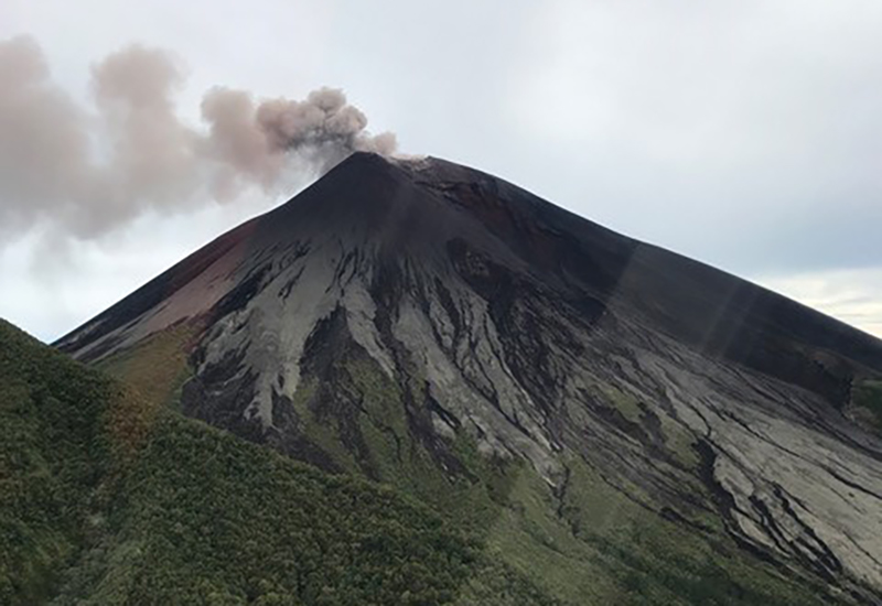 |
Figure 17. Photograph of a small ash plume rising from the summit crater of Ulawun taken by a helicopter pilot at 1030 local time on 26 June 2019. According to the pilot, the amount of ash observed was not unusual. Image has been color adjusted from original. Courtesy of Craig Powell. |
The Darwin VAAC issued several notices about ash plumes visible in satellite data. These stated that during 1130-1155 ash plumes rose to altitudes of 6.7-8.5 km and drifted W, while ash plumes that rose to 12.8-13.4 km drifted S and SW. A new pulse of activity (figures 17 and 18) generated ash plumes that by 1512 rose to an altitude of 16.8 km and drifted S and SE. By 1730 the ash plume had risen to 19.2 km and spread over 90 km in all directions. Ash from earlier ejections continued to drift S at an altitude of 13.4 km and W at an altitude of 8.5 km. RVO stated that RSAM values peaked at about 2,500 units during 1330-1600, and then dropped to 1,600 units as the eruption subsided.
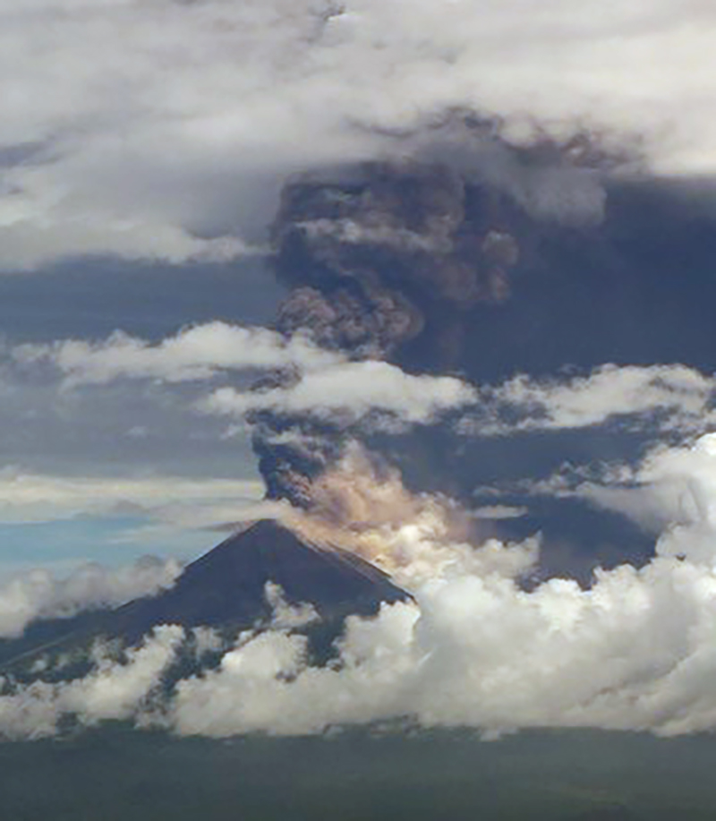 |
Figure 18. Photograph of Ulawun taken by a helicopter pilot at 1310 local time on 26 June 2019 showing a tall ash plume rising from the summit crater. Image has been color adjusted from original. Courtesy of Craig Powell. |
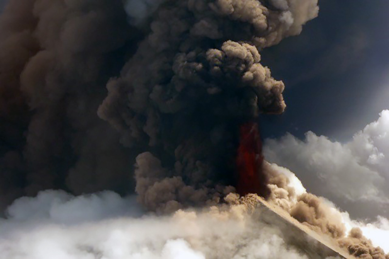 |
Figure 19. Photograph of Ulawun taken by a helicopter pilot at 1350 local time on 26 June 2019 showing a close-up view of the ash plume rising from the summit crater along with an area of incandescent ejecta. According to the pilot, this was the most active phase. Image has been color adjusted from original. Courtesy of Craig Powell. |
According to RVO, parts of the ash plume at lower altitudes drifted W, causing variable amounts of ashfall in areas to the NW and SW. A pyroclastic flow descended the N flank. Residents evacuated to areas to the NE and W; a news article (Radio New Zealand) noted that around 3,000 people had gathered at a local church. According to another news source (phys.org), an observer in a helicopter reported a column of incandescent material rising from the crater, residents noted that the sky had turned black, and a main road in the N part of the island was blocked by volcanic material. Residents also reported a lava flow near Noau village and Eana Valley. RVO reported that the eruption ceased between 1800 and 1900. Incandescence visible on the N flank was from either a lava flow or pyroclastic flow deposits.
On 27 June diffuse white plumes were reported by RVO as rising from the summit crater and incandescence was visible from pyroclastic or lava flow deposits on the N flank from the activity the day before. The seismic station 11 km NW of the volcano recorded low RSAM values of between 2 and 50. According to the Darwin VAAC a strong thermal anomaly was visible in satellite images, though not after 1200. Ash from 26 June explosions continued to disperse and became difficult to discern in satellite images by 1300, though a sulfur dioxide signal persisted. Ash at an altitude of 13.7 km drifted SW to SE and dissipated by 1620, and ash at 16.8 km drifted NW to NE and dissipated by 1857. RVO noted that at 1300 on 27 June satellite images captured an ash explosion not reported by ground-based observers, likely due to cloudy weather conditions. The Alert Level was lowered to Stage 1 (the lowest level on a four-stage scale).
RSAM values slightly increased at 0600 on 28 June and fluctuated between 80 to 150 units afterwards. During 28-29 June diffuse white plumes continued to rise from the crater (figure 20) and from the North Valley vent. On 29 June a ReliefWeb update stated that around 11,000 evacuated people remained in shelters.
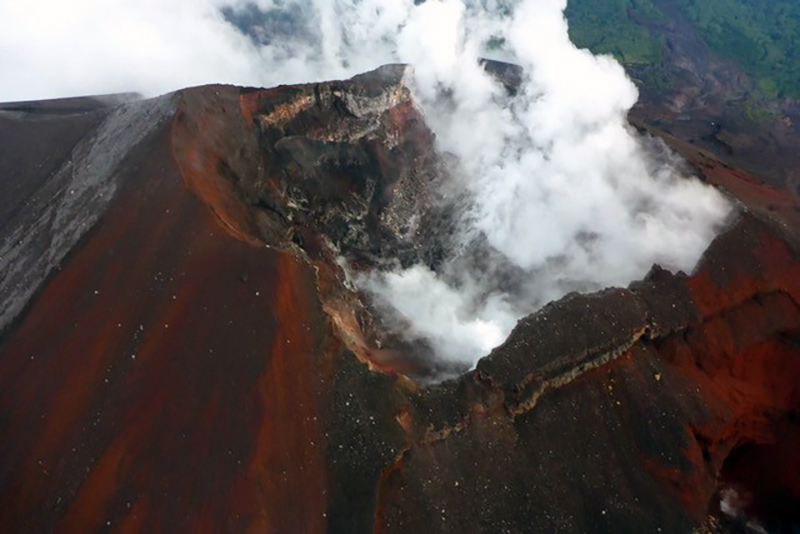 |
Figure 20. Photograph of the steaming summit crater at Ulawun taken by a helicopter pilot at 0730 local time on 29 June 2019. Image has been color adjusted from original. Courtesy of Craig Powell. |
According to RVO, diffuse white plumes rose from Ulawun's summit crater and the North Valley vent during 1-4 July and from the summit only during 5-9 July. The seismic station located 11 km NW of the volcano recorded three volcanic earthquakes and some sporadic, short-duration, volcanic tremors during 1-3 July. The seismic station 2.9 km W of the volcano was restored on 4 July and recorded small sub-continuous tremors. Some discrete high-frequency volcanic earthquakes were also recorded on most days. Sulfur dioxide emissions were 100 tonnes per day on 4 July. According to the United Nations in Papua New Guinea, 7,318 people remained displaced within seven sites because of the 26 June eruption.
Activity during August 2019. During 1-2 August RVO reported that white-to-gray vapor plumes rose from the summit crater and drifted NW. Incandescence from the summit crater was visible at night and jetting noises were audible for a short interval. RSAM values fluctuated but peaked at high levels. During the night of 2-3 August crater incandescence strengthened and roaring noises became louder around 0400. An explosion began between 0430 and 0500 on 3 August; booming noises commenced around 0445. By 0600 dense light-gray ash emissions were drifting NW, causing ashfall in areas downwind, including Ulamona Mission (10 km NW). Ash emissions continued through the day and changed from light to dark gray with time.
The eruption intensified at 1900 and a lava fountain rose more than 100 m above the crater rim. A Plinian ash plume rose 19 km and drifted W and SW, causing ashfall in areas downwind such as Navo and Kabaya, and as far as Kimbe Town (142 km SW). The Darwin VAAC reported that the ash plume expanded radially and reached the stratosphere, rising to an altitude of 19.2 km. The plume then detached and drifted S and then SE.
The Alert Level was raised to Stage 3. The areas most affected by ash and scoria fall were between Navo (W) and Saltamana Estate (NW). Two classrooms at the Navo Primary School and a church in Navo collapsed from the weight of the ash and scoria; one of the classroom roofs had already partially collapsed during the 26 June eruption. Evacuees in tents because of the 26 June explosion reported damage. Rabaul town (132 km NE) also reported ashfall. Seismicity declined rapidly within two hours of the event, though continued to fluctuate at moderate levels. According to a news source (Radio New Zealand, flights in and out of Hoskins airport in Port Moresby were cancelled on 4 August due to tephra fall. The Alert Level was lowered to Stage 1. Small amounts of white and gray vapor were emitted from the summit crater during 4-6 August. RVO reported that during 7-8 August minor emissions of white vapor rose from the summit crater.
Additional observations. Seismicity was dominated by low-level volcanic tremor and remained at low-to-moderate levels. RSAM values fluctuated between 400 and 550 units; peaks did not go above 700. Instruments aboard NASA satellites detected high levels of sulfur dioxide near or directly above the volcano on 26-29 June and 4-6 August 2019.
Thermal anomalies, based on MODIS satellite instruments analyzed using the MODVOLC algorithm, were observed at Ulawun only on 26 June 2019 (8 pixels by the Terra satellite, 4 pixels by the Aqua satellite). The MIROVA (Middle InfraRed Observation of Volcanic Activity) system detected three anomalies during the reporting period, one during the last week of June 2019 and two during the first week of August, all three within 3 km of the volcano and of low to moderate energy.
Geological Summary. The symmetrical basaltic-to-andesitic Ulawun stratovolcano is the highest volcano of the Bismarck arc, and one of Papua New Guinea's most frequently active. The volcano, also known as the Father, rises above the N coast of the island of New Britain across a low saddle NE of Bamus volcano, the South Son. The upper 1,000 m is unvegetated. A prominent E-W escarpment on the south may be the result of large-scale slumping. Satellitic cones occupy the NW and E flanks. A steep-walled valley cuts the NW side, and a flank lava-flow complex lies to the south of this valley. Historical eruptions date back to the beginning of the 18th century. Twentieth-century eruptions were mildly explosive until 1967, but after 1970 several larger eruptions produced lava flows and basaltic pyroclastic flows, greatly modifying the summit crater.
Information Contacts: Rabaul Volcano Observatory (RVO), Geohazards Management Division, Department of Mineral Policy and Geohazards Management (DMPGM), PO Box 3386, Kokopo, East New Britain Province, Papua New Guinea; Darwin Volcanic Ash Advisory Centre (VAAC), Bureau of Meteorology, Northern Territory Regional Office, PO Box 40050, Casuarina, NT 0811, Australia (URL: http://www.bom.gov.au/info/vaac/); Global Sulfur Dioxide Monitoring Page, Atmospheric Chemistry and Dynamics Laboratory, NASA Goddard Space Flight Center (NASA/GSFC), 8800 Greenbelt Road, Goddard, Maryland, USA (URL: https://so2.gsfc.nasa.gov/); Hawai'i Institute of Geophysics and Planetology (HIGP) - MODVOLC Thermal Alerts System, School of Ocean and Earth Science and Technology (SOEST), Univ. of Hawai'i, 2525 Correa Road, Honolulu, HI 96822, USA (URL: http://modis.higp.hawaii.edu/); MIROVA (Middle InfraRed Observation of Volcanic Activity), a collaborative project between the Universities of Turin and Florence (Italy) supported by the Centre for Volcanic Risk of the Italian Civil Protection Department (URL: http://www.mirovaweb.it); ReliefWeb (URL: https://reliefweb.int/); Radio New Zealand (URL: https://www.rnz.co.nz); phys.org (URL: https://phys.org); United Nations in Papua New Guinea (URL: http://pg.one.un.org/content/unct/papua_new_guinea/en/home.html).