Report on Dukono (Indonesia) — October 2019

Bulletin of the Global Volcanism Network, vol. 44, no. 10 (October 2019)
Managing Editor: Edward Venzke.
Research and preparation by Paul Berger.
Dukono (Indonesia) Eruption with frequent ash plumes continues through September 2019
Please cite this report as:
Global Volcanism Program, 2019. Report on Dukono (Indonesia) (Venzke, E., ed.). Bulletin of the Global Volcanism Network, 44:10. Smithsonian Institution. https://doi.org/10.5479/si.GVP.BGVN201910-268010
Dukono
Indonesia
1.6992°N, 127.8783°E; summit elev. 1273 m
All times are local (unless otherwise noted)
The eruption at Dukono, ongoing since 1933, is typified by frequent ash explosions and ash plumes (BGVN 43:04). This activity continued through at least September 2019. The data below were primarily provided by the Pusat Vulkanologi dan Mitigasi Bencana Geologi (PVMBG), also known as the Center for Volcanology and Geological Hazard Mitigation (CVGHM), and the Darwin Volcanic Ash Advisory Centre (VAAC).
According to PVMBG, during April-September 2019 the volcano continued to generate ash plumes almost every day that rose to altitudes of 1.5-3 km (table 20, figure 12). Ashfall was reported on 8 August at the Galela Airport, Maluku Utara, 17 km NW. The Alert Level remained at 2 (on a scale of 1-4), and the 2-km exclusion zone remained in effect.
Table 20. Monthly summary of reported ash plumes from Dukono for April-September 2019. The direction of drift for the ash plume through each month was highly variable, but did not extend for any notable distances during this reporting period. Data courtesy of the Darwin VAAC and PVMBG.
| Month | Plume Altitude (km) | Notable Plume Drift |
| Apr 2019 | 1.5-2.4 | -- |
| May 2019 | 1.5-3 | -- |
| Jun 2019 | 1.8-2.4 | -- |
| Jul 2019 | 1.5-2.1 | -- |
| Aug 2019 | 1.8-2.1 | -- |
| Sep 2019 | 1.5-2.1 | -- |
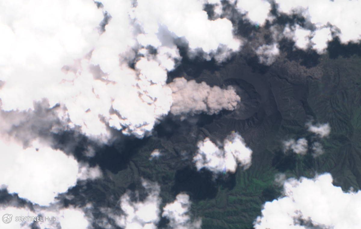 |
Figure 12. Satellite image from Sentinel-2 (natural color) of an ash plume at Dukono on 4 August 2019, with the plume blowing almost straight up. Courtesy of Sentinel Hub Playground. |
Instruments aboard NASA satellites detected high levels of sulfur dioxide near or directly above the volcano on 11, 20-22 April; 17, 22, and 27 May; 15-18 August; and 23-24 and 29 September. However, the cause of the high levels may, at least in part, have been due to other active volcanoes in the area.
Geological Summary. The Dukono complex in northern Halmahera is on an edifice with a broad, low profile containing multiple peaks and overlapping craters. Almost continuous explosive eruptions, sometimes accompanied by lava flows, have occurred since 1933. During a major eruption in 1550 CE, a lava flow filled in the strait between Halmahera and the Gunung Mamuya cone, 10 km NE. Malupang Wariang, 1 km SW of the summit crater complex, contains a 700 x 570 m crater that has also had reported eruptions.
Information Contacts: Pusat Vulkanologi dan Mitigasi Bencana Geologi (PVMBG, also known as Indonesian Center for Volcanology and Geological Hazard Mitigation, CVGHM), Jalan Diponegoro 57, Bandung 40122, Indonesia (URL: http://www.vsi.esdm.go.id/); Darwin Volcanic Ash Advisory Centre (VAAC), Bureau of Meteorology, Northern Territory Regional Office, PO Box 40050, Casuarina, NT 0811, Australia (URL: http://www.bom.gov.au/info/vaac/); Global Sulfur Dioxide Monitoring Page, Atmospheric Chemistry and Dynamics Laboratory, NASA Goddard Space Flight Center (NASA/GSFC), 8800 Greenbelt Road, Goddard, Maryland, USA (URL: https://so2.gsfc.nasa.gov/); Sentinel Hub Playground (URL: https://www.sentinel-hub.com/explore/sentinel-playground).