Report on Agung (Indonesia) — November 2019

Bulletin of the Global Volcanism Network, vol. 44, no. 11 (November 2019)
Managing Editor: Edward Venzke.
Edited by A. Elizabeth Crafford.
Agung (Indonesia) Quiet returns after explosions on 10 and 13 June 2019
Please cite this report as:
Global Volcanism Program, 2019. Report on Agung (Indonesia) (Crafford, A.E., and Venzke, E., eds.). Bulletin of the Global Volcanism Network, 44:11. Smithsonian Institution. https://doi.org/10.5479/si.GVP.BGVN201911-264020
Agung
Indonesia
8.343°S, 115.508°E; summit elev. 2997 m
All times are local (unless otherwise noted)
After a large, deadly explosive and effusive eruption during 1963-64, Indonesia's Mount Agung on Bali remained quiet until a new eruption began in November 2017 (BGVN 43:01). Activity continued throughout 2018 with explosions that produced ash plumes rising multiple kilometers above the summit, and the slow effusion of the lava within the summit crater. Increasingly frequent and intense explosions with ash emissions and incandescent ejecta characterized activity during February through May 2019 (BGVN 44:06). Two more explosions in June 2019 produced significant ash plumes; no further explosive activity occurred through October 2019. Information about Agung comes from Pusat Vulkanologi dan Mitigasi Bencana Geologi (PVMBG), also known as the Indonesian Center for Volcanology and Geological Hazard Mitigation (CVGHM), the Darwin Volcanic Ash Advisory Center (VAAC), and multiple sources of satellite data. This report covers the end of the eruption in June and observations through October 2019.
After a large explosion on 31 May 2019, a smaller event occurred on 10 June. Another large explosion with an ash plume that rose to 9.1 km altitude was recorded on 13 June (local time). It drifted hundreds of kilometers before dissipating. No further explosive activity was reported through October 2019, only diffuse white steam plumes rising at most a few hundred meters above the summit. The Alert Level remained at III (of four levels) throughout the period. The record of thermal activity showed an increase during the explosive events of late May and June, but then decreased significantly (figure 57). There was no obvious thermal signature in satellite images that explained the small increase in thermal energy recorded by the MIROVA data at the end of August 2019.
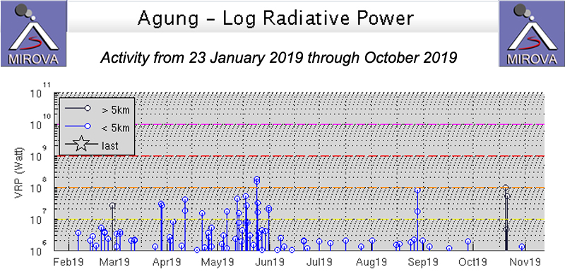 |
Figure 57. The thermal energy at Agung increased significantly during the explosive events of late May and early June 2019, and then decreased substantially as seen in this MIROVA graph from 23 January through October 2019. There was no obvious satellite thermal signature to explain the brief increase in thermal energy in late August. Courtesy of MIROVA. |
On 31 May 2019 a large explosion produced an ash plume that rose more than 2 km above the summit (BGVN 44:06, figure 56). The Darwin VAAC reported that it split into two plumes, one drifted E at 8.2 km and the other ESE at 6.1 km altitude, dissipating after about 20 hours early on 1 June. A small eruption with an ash plume that rose to 3.9 km altitude was reported the next day by the Darwin VAAC. It was detected in the webcam and pilot reports confirmed that it drifted E for a few hours before dissipating. PVMBG reported gray emissions to 300 m above the peak on 1 June and 100 m above the summit on 2 June. By 6 June the emissions were white, rising only 50 m above the summit. For several subsequent days, the summit was covered in fog with no observations of emissions.
On 10 June 2019 an explosion lasting 90 seconds was reported at 1212 local time; PVMBG noted a gray ash plume 1,000 m above the summit (figure 58). The Darwin VAAC confirmed the emission in satellite imagery and by pilot report; it was moving SW at 4.3 km altitude and then drifted S before dissipating by the end of the day. Early on 13 June local time (12 June UTC) a new explosion that was clearly visible in the webcam produced a large ash plume that drifted W and SW (figure 59). The explosion was recorded on the seismogram for almost four minutes and sent incandescent ejecta in all directions up to 700 m from the summit. The first satellite imagery of the plume reported by the Darwin VAAC suggested the altitude to be 9.1 km. A secondary plume was drifting W from the summit at 5.5 km altitude a few hours later. By six hours after the eruption, the 9.1 km altitude plume was about 90 km SSW of the Denpassar airport and the 5.5 km altitude plume was about 110 km W of the airport. By the time the higher altitude plume dissipated after about 14 hours, it had reached 300 km S of the airport. For the remainder of June, only diffuse white steam plumes were reported, rising generally 30-50 m above the summit, with brief pulses to 150-200 m during 27-29 June.
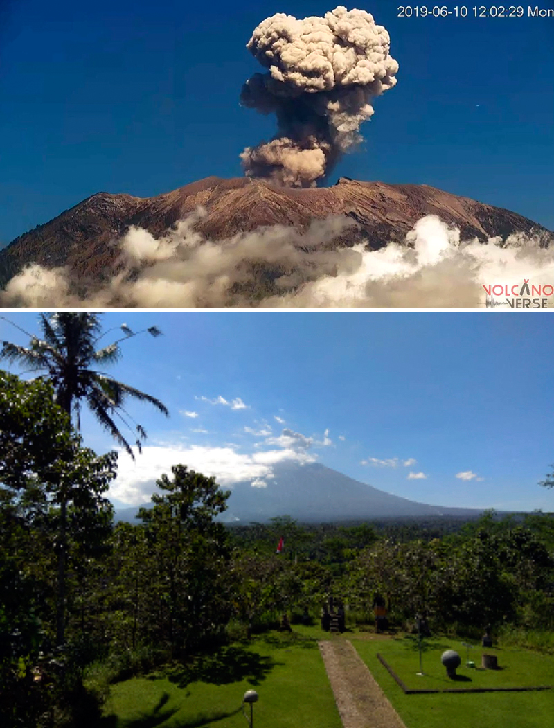 |
Figure 58. An ash plume rose 1,000 m above the summit of Agung on 10 June 2019. Top image courtesy of Rita Bauer (Volcano Verse), bottom image courtesy of PVMBG (Information on G. Agung Eruption, 10 June 2019). |
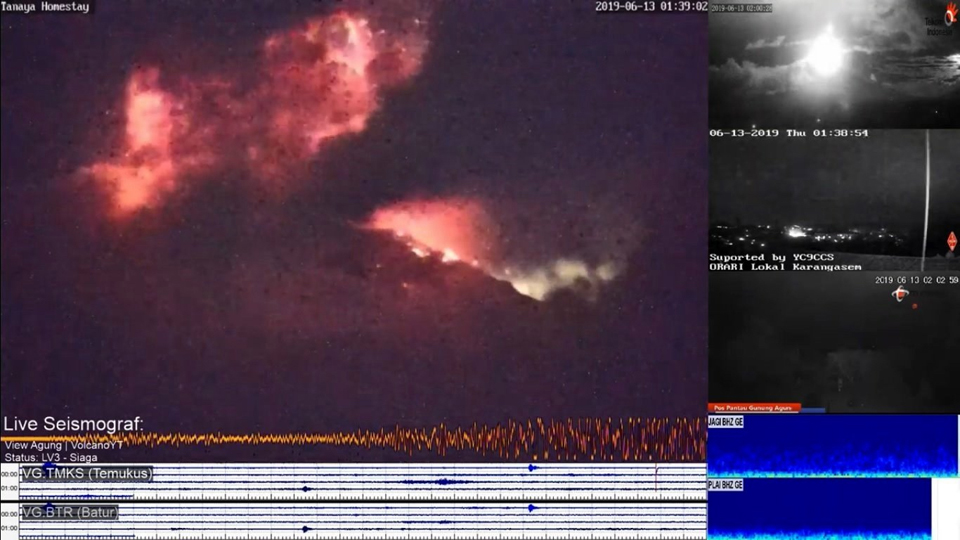 |
Figure 59. A large eruption at Agung at 0138 local time on 13 June 2019 sent an ash plume to 9.1 km altitude and incandescent ejecta 700 m in all directions. Courtesy of Jaime S. Sincioco, screenshot from volcano YT webcam. |
Although no further surface activity was reported at Agung during July through October 2019, PVMBG kept the Alert Level at III throughout the period. Only steam plumes were reported from the summit usually rising 50 m before dissipating. Steam emissions rose to 150 m a few times each month. Plumes were reported at 300 m above the summit on 6 July and 15 August. No thermal anomalies were visible in Sentinel 2 satellite images during the period.
Geological Summary. Symmetrical Agung stratovolcano, Bali's highest and most sacred mountain, towers over the eastern end of the island. The volcano, whose name means "Paramount," rises above the SE rim of the Batur caldera, and the northern and southern flanks extend to the coast. The summit area extends 1.5 km E-W, with the high point on the W and a steep-walled 800-m-wide crater on the E. The Pawon cone is located low on the SE flank. Only a few eruptions dating back to the early 19th century have been recorded in historical time. The 1963-64 eruption, one of the largest in the 20th century, produced voluminous ashfall along with devastating pyroclastic flows and lahars that caused extensive damage and many fatalities.
Information Contacts: Pusat Vulkanologi dan Mitigasi Bencana Geologi (PVMBG, also known as Indonesian Center for Volcanology and Geological Hazard Mitigation, CVGHM), Jalan Diponegoro 57, Bandung 40122, Indonesia (URL: http://www.vsi.esdm.go.id/); MIROVA (Middle InfraRed Observation of Volcanic Activity), a collaborative project between the Universities of Turin and Florence (Italy) supported by the Centre for Volcanic Risk of the Italian Civil Protection Department (URL: http://www.mirovaweb.it/); Rita Bauer, Volcano Verse (Twitter @wischweg, URL: https://twitter.com/wischweg/status/1137956367258570752); Jamie S. Sincioco, Philippines (Twitter @jaimessincioco, URL: https://twitter.com/jaimessincioco/status/1139109685796020224).