Report on Karangetang (Indonesia) — December 2019

Bulletin of the Global Volcanism Network, vol. 44, no. 12 (December 2019)
Managing Editor: Edward Venzke.
Edited by Kadie L. Bennis.
Karangetang (Indonesia) Lava flows, strong thermal anomalies, gas-and-steam emissions, and ash plumes during May-November 2019
Please cite this report as:
Global Volcanism Program, 2019. Report on Karangetang (Indonesia) (Bennis, K.L., and Venzke, E., eds.). Bulletin of the Global Volcanism Network, 44:12. Smithsonian Institution. https://doi.org/10.5479/si.GVP.BGVN201912-267020
Karangetang
Indonesia
2.781°N, 125.407°E; summit elev. 1797 m
All times are local (unless otherwise noted)
Karangetang (also known as Api Siau), located on the island of Siau in the Sitaro Regency, North Sulawesi, Indonesia, has experienced more than 40 recorded eruptions since 1675 in addition to many smaller undocumented eruptions. In early February 2019, a lava flow originated from the N crater (Kawah Dua) traveling NNW and reaching a distance over 3 km. Recent monitoring showed a lava flow from the S crater (Kawah Utama, also considered the "Main Crater") traveling toward the Kahetang and Batuawang River drainages on 15 April 2019. Gas-and-steam emissions, ash plumes, moderate seismicity, and thermal anomalies including lava flow activity define this current reporting period for May through November 2019. The primary source of information for this report comes from daily and weekly reports by the Pusat Vulkanologi dan Mitigasi Bencana Geologi (PVMBG, also known as CVGHM, or the Center of Volcanology and Geological Hazard Mitigation), the Darwin Volcanic Ash Advisory Center (VAAC), and satellite data.
PVMBG reported that white gas-and-steam emissions were visible rising above both craters consistently between May through November 2019 (figures 30 and 31). The maximum altitude for these emissions was 400 m above the Dua Crater on 27 May and 700 m above the Main Crater on 12 June. Throughout the reporting period PVMBG noted that moderate seismicity occurred, which included both shallow and deep volcanic earthquakes.
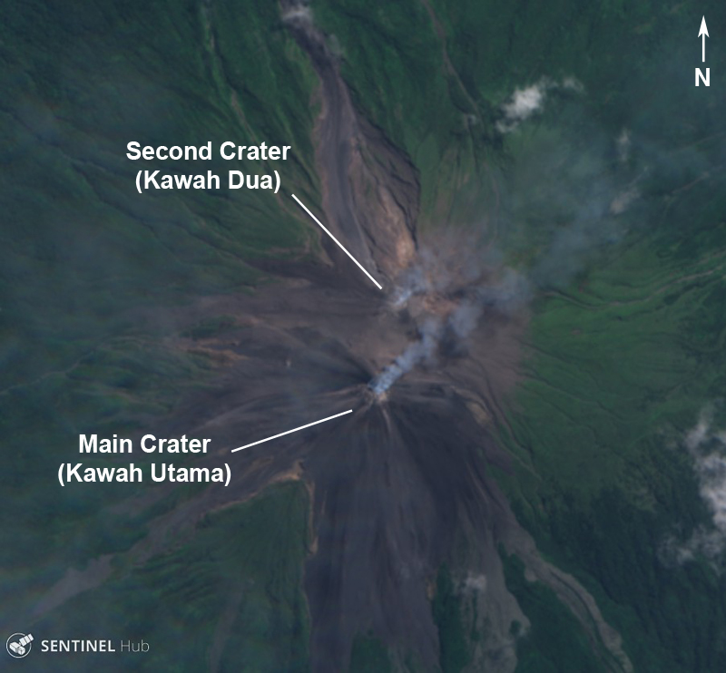 |
Figure 30. A Sentinel-2 image of Karangetang showing two active craters producing gas-and-steam emissions with a small amount of ash on 7 August 2019. Courtesy of Sentinel Hub Playground. |
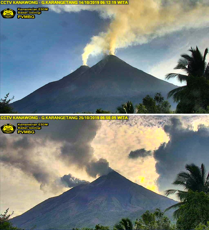 |
Figure 31. Webcam images of gas-and-steam emissions rising from the summit of Karangetang on 14 (top) and 25 (bottom) October 2019. Courtesy of PVMBG via Øystein Lund Andersen. |
Activity was relatively low between May and June 2019, consisting mostly of gas-and-steam emissions. On 26-27 May 2019 crater incandescence was observed above the Main Crater; white gas-and-steam emissions were rising from both craters (figures 32 and 33). At 1858 on 20 July, incandescent avalanches of material originating from the Main Crater traveled as far as 1 km W toward the Pangi and Kinali River drainages. By 22 July the incandescent material had traveled another 500 m in the same direction as well as 1 km in the direction of the Nanitu and Beha River drainages. According to a Darwin VAAC report, discreet, intermittent ash eruptions on 30 July resulted in plumes drifting W at 7.6 km altitude and SE at 3 km, as observed in HIMAWARI-8 satellite imagery.
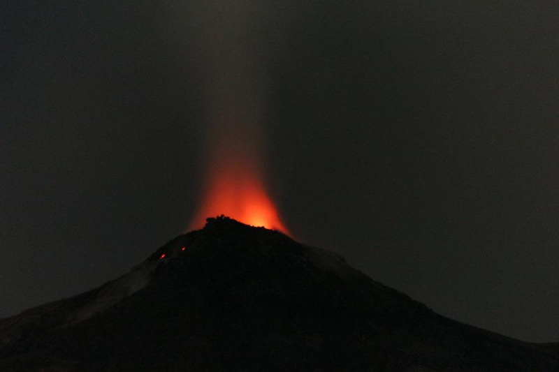 |
Figure 32. Photograph of summit crater incandescence at Karangetang on 12 May 2019. Courtesy of Dominik Derek. |
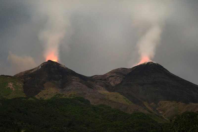 |
Figure 33. Photograph of both summit crater incandescence at Karangetang on 12 May 2019 accompanied by gas-and-steam emissions. Courtesy of Dominik Derek. |
On 5 August 2019 a minor eruption produced an ash cloud that rose 3 km and drifted E. PVMBG reported in the weekly report for 5-11 August that an incandescent lava flow from the Main Crater was traveling W and SW on the slopes of Karangetang and producing incandescent avalanches (figure 34). During 12 August through 1 September lava continued to effuse from both the Main and Dua craters. Avalanches of material traveled as far as 1.5 km SW toward the Nanitu and Pangi River drainages, 1.4-2 km to the W of Pangi, and 1.8 km down the Sense River drainage. Lava fountaining was observed occurring up to 10 m above the summit on 14-20 August.
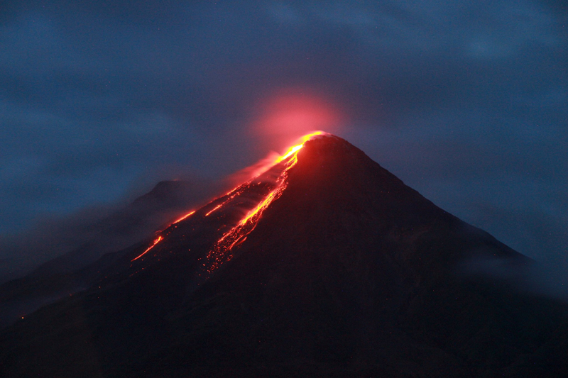 |
Figure 34. Photograph of summit crater incandescence and a lava flow from Karangetang on 7 August 2019. Courtesy of MAGMA Indonesia. |
PVMBG reported that during 2-22 September lava continued to effuse from both craters, traveling SW toward the Nanitu, Pangi, and Sense River drainages as far as 1.5 km. On 24 September the lava flow occasionally traveled 0.8-1.5 km toward the West Beha River drainage. The lava flow from the Main Crater continued through at least the end of November, moving SW and W as far as 1.5 km toward the Nanitu, Pangi, and Sense River drainages. In late October and onwards, incandescence from both summit craters was observed at night. The lava flow often traveled as far as 1 km toward the Batang and East Beha River drainage on 12 November, the West Beha River drainage on 15, 22, 24, and 29 November, and the Batang and West Beha River drainages on 25-27 November (figure 35). On 30 November a Strombolian eruption occurred in the Main Crater accompanied by gas-and-steam emissions rising 100 m above the Main Crater and 50 m above the Dua Crater. Lava flows traveled SW and W toward the Nanitu, Sense, and Pangi River drainages as far as 1.5 km, the West Beha and Batang River drainages as far as 1 km, and occasionally the Batu Awang and Kahetang River drainages as far as 2 km. Lava fountaining was reported occurring 10-25 m above the Main Crater and 10 m above the Dua Crater on 6, 8-12, 15, 21-30 November.
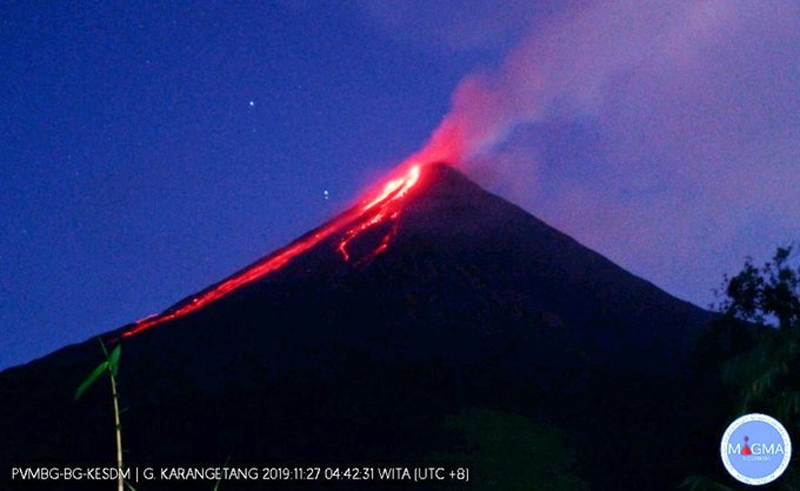 |
Figure 35. Webcam image of gas-and-steam emissions rising from the summit of Karangetang accompanied by incandescence and lava flows at night on 27 November 2019. Courtesy of MAGMA Indonesia via Øystein Lund Andersen. |
MIROVA (Middle InfraRed Observation of Volcanic Activity) analysis of MODIS satellite data showed consistent and strong thermal anomalies within 5 km of the summit craters from late July through November 2019 (figure 36). Satellite imagery from Sentinel-2 corroborated this data, showing strong thermal anomalies and lava flows originating from both craters during this same timeframe (figure 37). In addition to these lava flows, satellite imagery also captured intermittent gas-and-steam emissions from May through November (figure 38). MODVOLC thermal alerts registered 165 thermal hotspots near Karangetang's summit between May and November.
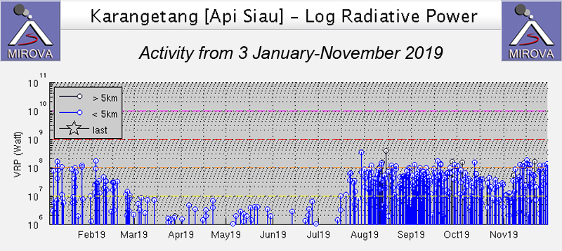 |
Figure 36. Frequent and strong thermal anomalies at Karangetang between 3 January through November 2019 as recorded by the MIROVA system (Log Radiative Power) began in late July and were recorded within 5 km of the summit craters. Courtesy of MIROVA. |
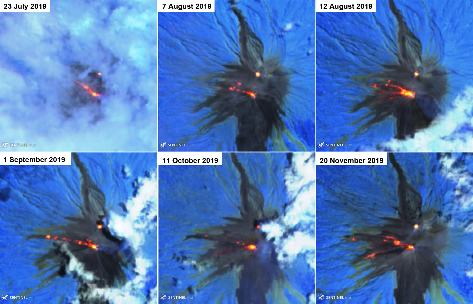 |
Figure 37. Sentinel-2 thermal satellite imagery (bands 12, 11, 8A) confirmed ongoing thermal activity (bright orange) at Karangetang from July into November 2019. The lava flows traveled dominantly in the W direction from the Main Crater. Courtesy of Sentinel Hub Playground. |
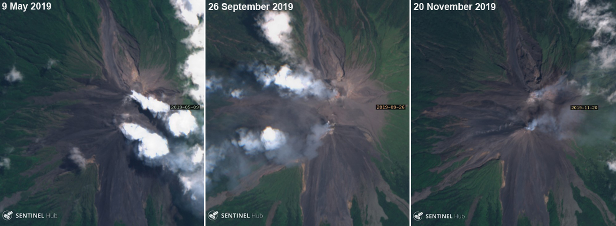 |
Figure 38. Sentinel-2 satellite imagery showing gas-and-steam emissions with a small amount of ash (middle and right) rising from both craters of Karangetang during May through November 2019. Courtesy of Sentinel Hub Playground. |
Sentinel-5P/TROPOMI satellite data detected multiple sulfur dioxide plumes between May and November 2019 (figure 39). These emissions occasionally exceeded 2 Dobson Units (DU) and drifted in different directions based on the dominant wind pattern.
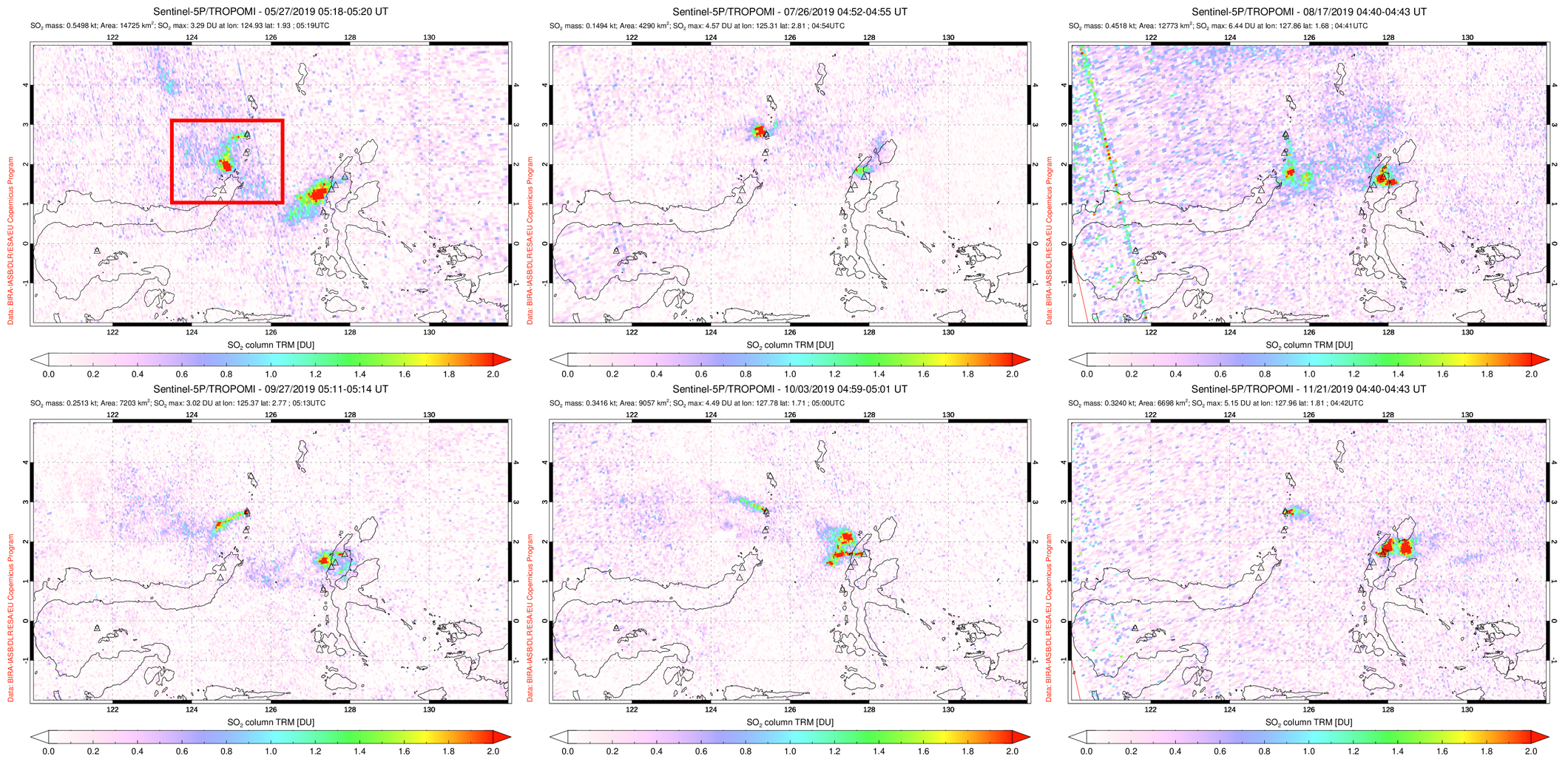 |
Figure 39. SO2 emissions from Karangetang (indicated by the red box) were seen in TROPOMI instrument satellite data during May through November 2019, many of which drifted in different directions based on the prevailing winds. Top left: 27 May 2019. Top middle: 26 July 2019. Top right: 17 August 2019. Bottom left: 27 September 2019. Bottom middle: 3 October 2019. Bottom right: 21 November 2019. Courtesy of NASA Goddard Space Flight Center. |
Geological Summary. Karangetang (Api Siau) volcano lies at the northern end of the island of Siau, about 125 km NNE of the NE-most point of Sulawesi. The stratovolcano contains five summit craters along a N-S line. It is one of Indonesia's most active volcanoes, with more than 40 eruptions recorded since 1675 and many additional small eruptions that were not documented (Neumann van Padang, 1951). Twentieth-century eruptions have included frequent explosive activity sometimes accompanied by pyroclastic flows and lahars. Lava dome growth has occurred in the summit craters; collapse of lava flow fronts have produced pyroclastic flows.
Information Contacts: Pusat Vulkanologi dan Mitigasi Bencana Geologi (PVMBG, also known as Indonesian Center for Volcanology and Geological Hazard Mitigation, CVGHM), Jalan Diponegoro 57, Bandung 40122, Indonesia (URL: http://www.vsi.esdm.go.id/); MAGMA Indonesia, Kementerian Energi dan Sumber Daya Mineral (URL: https://magma.vsi.esdm.go.id/); Darwin Volcanic Ash Advisory Centre (VAAC), Bureau of Meteorology, Northern Territory Regional Office, PO Box 40050, Casuarina, NT 0811, Australia (URL: http://www.bom.gov.au/info/vaac/); MIROVA (Middle InfraRed Observation of Volcanic Activity), a collaborative project between the Universities of Turin and Florence (Italy) supported by the Centre for Volcanic Risk of the Italian Civil Protection Department (URL: http://www.mirovaweb.it/); Hawai'i Institute of Geophysics and Planetology (HIGP) - MODVOLC Thermal Alerts System, School of Ocean and Earth Science and Technology (SOEST), Univ. of Hawai'i, 2525 Correa Road, Honolulu, HI 96822, USA (URL: http://modis.higp.hawaii.edu/); Global Sulfur Dioxide Monitoring Page, Atmospheric Chemistry and Dynamics Laboratory, NASA Goddard Space Flight Center (NASA/GSFC), 8800 Greenbelt Road, Goddard, Maryland, USA (URL: https://SO2.gsfc.nasa.gov/); Sentinel Hub Playground (URL: https://www.sentinel-hub.com/explore/sentinel-playground); Øystein Lund Andersen (Twitter: @OysteinLAnderse, https://twitter.com/OysteinLAnderse, URL: https://www.oysteinlundandersen.com); Dominik Derek (URL: https://www.facebook.com/07dominikderek/).