Report on Whakaari/White Island (New Zealand) — February 2020

Bulletin of the Global Volcanism Network, vol. 45, no. 2 (February 2020)
Managing Editor: Edward Venzke.
Edited by Janine B. Krippner.
Whakaari/White Island (New Zealand) Explosion producing an ash plume and pyroclastic surge resulted in fatalities and injuries on 9 December 2019
Please cite this report as:
Global Volcanism Program, 2020. Report on Whakaari/White Island (New Zealand) (Krippner, J.B., and Venzke, E., eds.). Bulletin of the Global Volcanism Network, 45:2. Smithsonian Institution. https://doi.org/10.5479/si.GVP.BGVN202002-241040
Whakaari/White Island
New Zealand
37.52°S, 177.18°E; summit elev. 294 m
All times are local (unless otherwise noted)
Whakaari/White Island has been New Zealand's most active volcano since 1976. Located 48 km offshore, the volcano is a popular tourism destination with tours leaving the town of Whakatane with approximately 17,500 people visiting the island in 2018. Ten lives were lost in 1914 when part of the crater wall collapsed, impacting sulfur miners. More recently, a brief explosion at 1411 on 9 December 2019 produced an ash plume and pyroclastic surge that impacted the entire crater area. With 47 people on the island at the time, the death toll stood at 21 on 3 February 2020. At that time more patients were still in hospitals within New Zealand or their home countries.
The island is the summit of a large underwater volcano, with around 70% of the edifice below the ocean and rising around 300 m above sea level (figure 70). A broad crater opens to the ocean to the SE, with steep crater walls and an active Main Crater area to the NW rear of the crater floor (figure 71). Although the island is privately owned, GeoNet continuously monitors activity both remotely and with visits to the volcano. This Bulletin covers activity from May 2017 through December 2019 and is based on reports by GeoNet, the New Zealand Civil Defence Bay of Plenty Emergency Management Group, satellite data, and footage taken by visitors to the island.
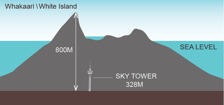 |
Figure 70. The top of the Whakaari/White Island edifice forms the island in the Bay of Plenty area, New Zealand, while 70% of the volcano is below sea level. Courtesy of GeoNet. |
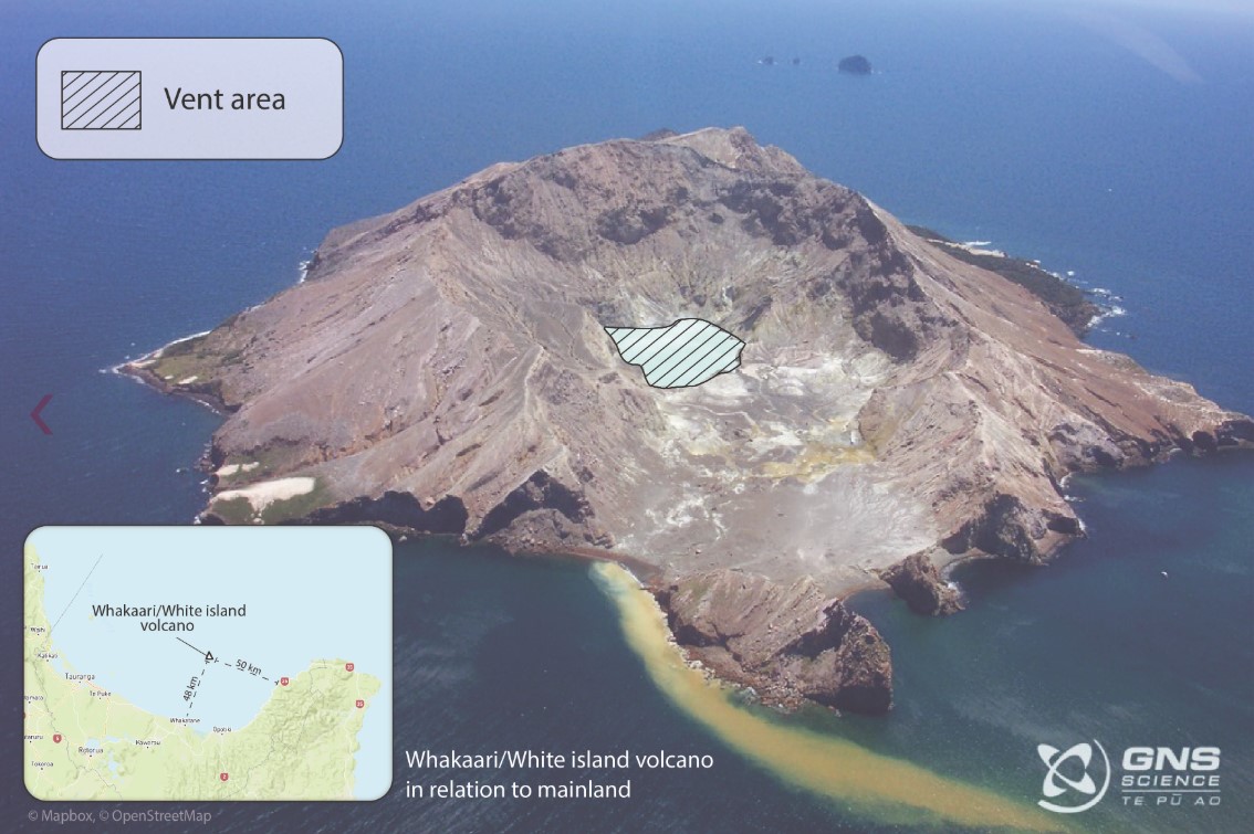 |
Figure 71. This photo from 2004 shows the Main Crater area of Whakaari/White Island with the vent area indicated. The crater is an amphitheater shape with the crater floor distance between the vent and the ocean entry being about 700 m. The sediment plume begins at the area where tour boats dock at the island. Photo by Karen Britten, graphic by Danielle Charlton at University of Auckland; courtesy of GeoNet (11 December 2019 report). |
Nearly continuous activity occurred from December 1975 to September 2000, including the formation of collapse and explosion craters producing ash emissions and explosions that impacted all of the Main Crater area. More recently, it has been in a state of elevated unrest since 2011. Renewed activity commenced with an explosive eruption on 5 August 2012 that was followed by the extrusion of a lava dome and ongoing phreatic explosions and minor ash emissions through March 2013. An ash cone was seen on 4 March 2013, and over the next few months the crater lake reformed. Further significant explosions took place on 20 August and 4, 8, and 11 October 2013. A landslide occurred in November 2015 with material descending into the lake. More recent activity on 27 April 2016 produced a short-lived eruption that deposited material across the crater floor and walls. A short period of ash emission later that year, on 13 September 2016, originated from a vent on the recent lava dome. Explosive eruptions occur with little to no warning.
Since 19 September 2016 the Volcanic Alert Level (VAL) was set to 1 (minor volcanic unrest) (figure 72). During early 2017 background activity in the crater continued, including active fumaroles emitting volcanic gases and steam from the active geothermal system, boiling springs, volcanic tremor, and deformation. By April 2017 a new crater lake had begun to form, the first since the April 2016 explosion when the lake floor was excavated an additional 13 m. Before this, there were areas where water ponded in depressions within the Main Crater but no stable lake.
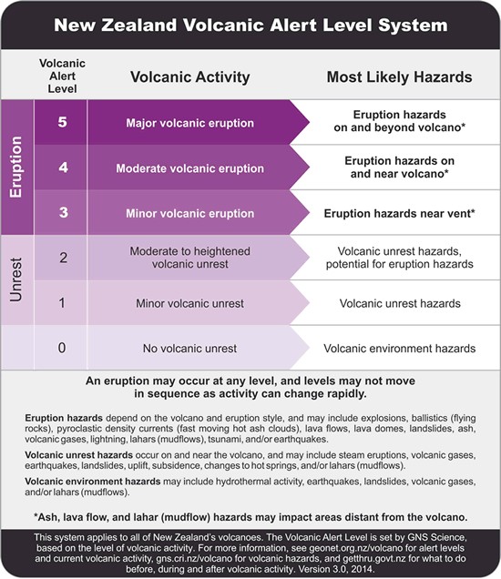 |
Figure 72. The New Zealand Volcanic Alert Level system up to date in February 2020. Courtesy of GeoNet. |
Activity from mid-2017 through 2018. In July-August 2017 GeoNet scientists carried out the first fieldwork at the crater area since late 2015 to sample the new crater lake and gas emissions. The crater lake was significantly cooler than the past lakes at 20°C, compared to 30-70°C that was typical previously. Chemical analysis of water samples collected in July showed the lowest concentrations of most "volcanic elements" in the lake for the past 10-15 years due to the reduced volcanic gases entering the lake. The acidity remained similar to that of battery acid. Gas emissions from the 2012 dome were 114°C, which were over 450°C in 2012 and 330°C in 2016. Fumarole 0 also had a reduced temperature of 152°C, reduced from over 190°C in late 2016 (figure 73). The observations and measurements indicated a decline in unrest. Further visits in December 2017 noted relatively low-level unrest including 149°C gas emissions from fumarole 0, a small crater lake, and loud gas vents nearby (figures 74 and 75). By 27 November the lake had risen to 10 m below overflow. Analysis of water samples led to an estimate of 75% of the lake water resulting from condensing steam vents below the lake and the rest from rainfall.
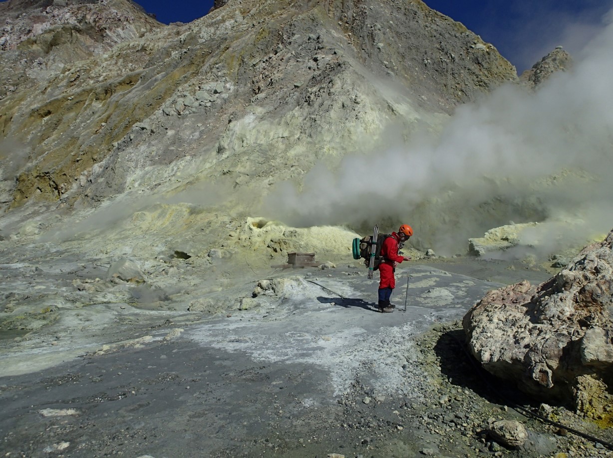 |
Figure 73. A GeoNet scientists conducting field work near Fumarole 0, an accessible gas vent on Whakaari/White Island in August 2017. Courtesy of GeoNet (23 August 2017 report). |
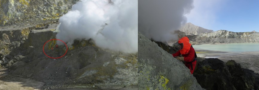 |
Figure 74. GeoNet scientists sample gas emissions from vents on the 2012 Whakaari/White Island dome. The red circle in the left image indicates the location of the scientists. Courtesy of GeoNet (23 August 2017 report). |
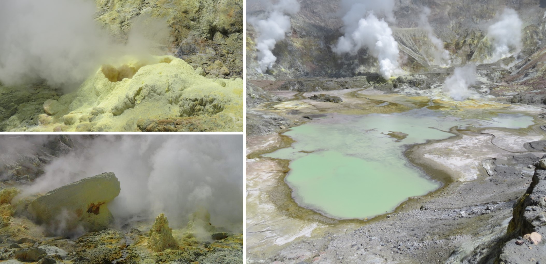 |
Figure 75. Active fumaroles and vents in the Main Crater of Whakaari/White Island including Fumarole 0 (top left). The crater lake formed in mid-2017 and gas emissions rise from surrounding vents (right). Courtesy of GeoNet (22 December 2017 report). |
Routine fieldwork by GeoNet monitoring teams in early March 2018 showed continued low-level unrest and no apparent changes after a recent nearby earthquake swarm. The most notable change was the increase in the crater lake size, likely a response from recent high rainfall (figure 76). The water remained a relatively cool 27°C. Temperatures continued to decline at the 2012 dome vent (128°C) and Fumarole 0 (138°C). Spring and stream flow had also declined. Deformation was observed towards the Active Crater of 2-5 mm per month and seismicity remained low. The increase in lake level drowned gas vents along the lake shore resulting in geyser-like activity (figure 77). GeoNet warned that a new eruption could occur at any time, often without any useful warning.
In mid-April 2018 visitors reported loud sounds from the crater area as a result of the rising lake level drowning vents on the 2012 dome (in the western side of the crater) and resulting in steam-driven activity. There was no notable change in volcanic activity. The sounds stopped by July 2018 as the geothermal system adjusted to the rising water, up to 17 m below overfill and filling at a rate of about 2,000 m3 per day, rising towards more active vents (figure 78). A gas monitoring flight taken on 12 September showed a steaming lake surrounded by active fumaroles along the crater wall (figure 79).
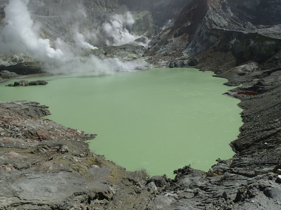 |
Figure 76. The increase in the Whakaari/White Island crater lake size in early March 2018 with gas plumes rising from vents on the other side. Courtesy of GeoNet (19 March 2018 report). |
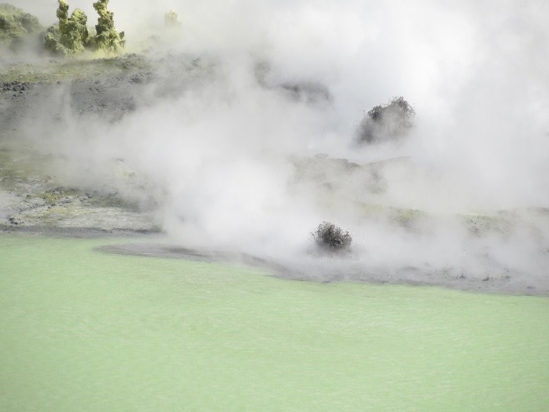 |
Figure 77. The increasing crater lake level at Whakaari/White Island produced geyser-like activity on the lake shore in March 2018. Courtesy of Brad Scott, GeoNet. |
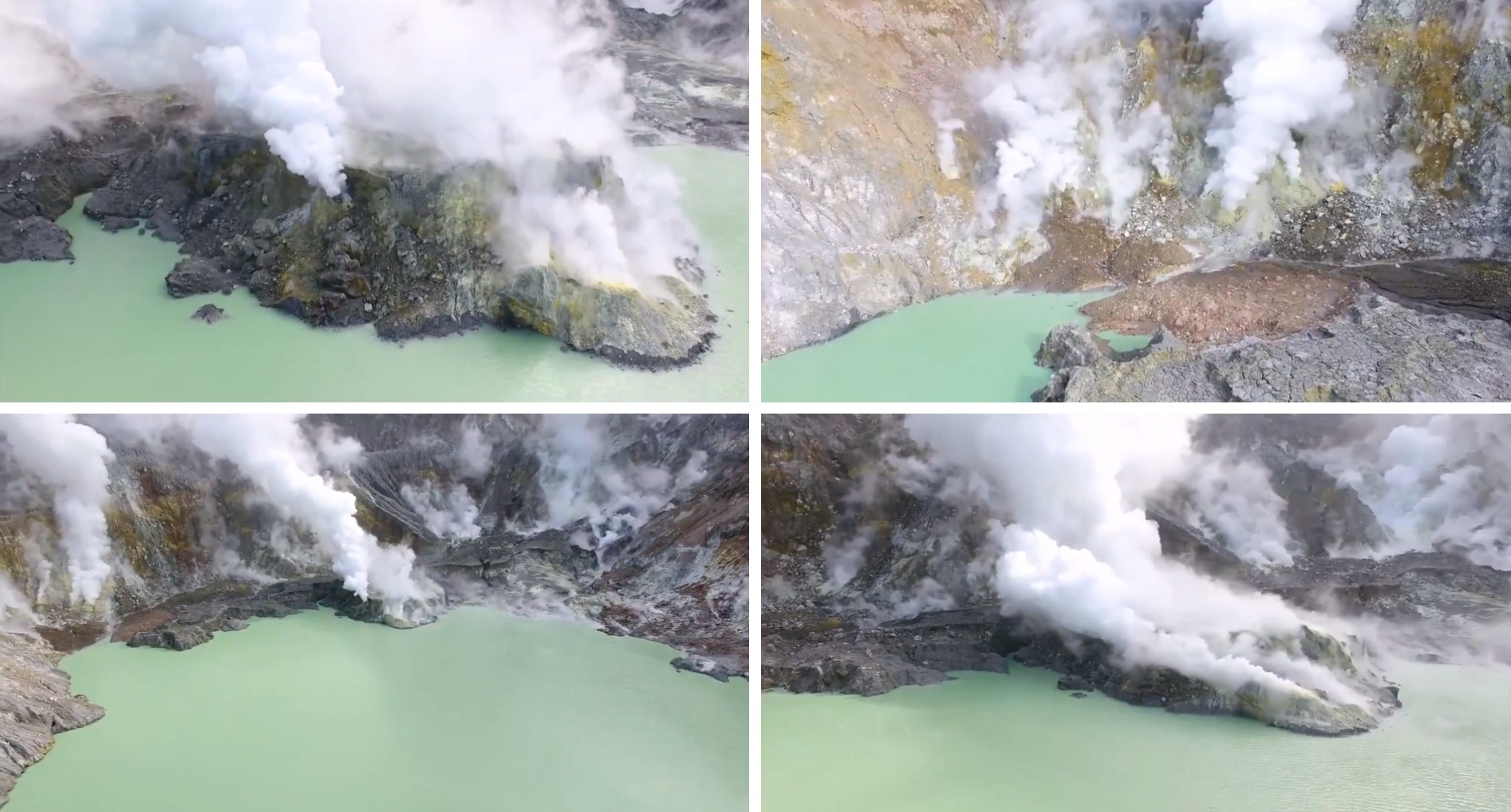 |
Figure 78. Stills taken from a drone video of the Whakaari/White Island Main Crater lake and active vents producing gas emissions. Courtesy of GeoNet. |
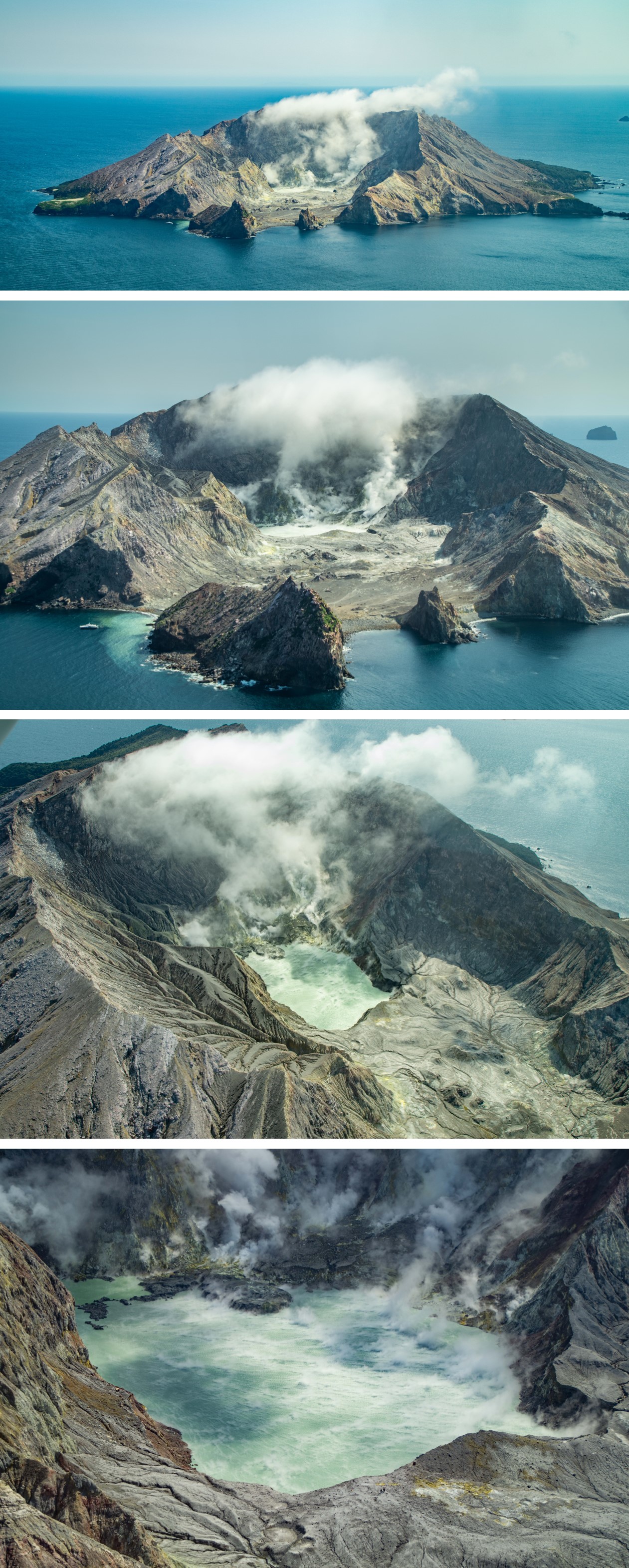 |
Figure 79. Photos taken during a gas monitoring flight with GNS Science at Whakaari/White Island show gas and steam emissions, and a steaming crater lake on 12 September 2018. Note the people for scale on the lower-right crater rim in the bottom photograph. Copyright of Ben Clarke, University of Leicester, used with permission. |
Activity during April to early December 2019. A GeoNet volcanic alert bulletin in April 2019 reported that steady low-level unrest continued. The level of the lake had been declining since late January and was back down to 13 m below overflow (figure 80). The water temperature had increased to over 60°C due to the fumarole activity below the lake. Fumarole 0 remained steady at around 120-130°C. During May-June a seismic swarm was reported offshore, unrelated to volcanic activity but increasing the risk of landslides within the crater due to the shallow locations.
 |
Figure 80. Planet Labs satellite images from March 2018 to April 2019 show fluctuations in the Whakaari/White Island crater lake level. Image copyright 2019 Planet Labs, Inc. |
On 26 June the VAL was raised to level 2 (moderate to heightened volcanic unrest) due to increased SO2 flux rising to historically high levels. An overflight that day detected 1,886 tons/day, nearly three times the previous values of May 2019, the highest recorded value since 2013, and the second highest since measurements began in 2003. The VAL was subsequently lowered on 1 July due to a reduction in detected SO2 emissions of 880 tons/day on 28 June and 693 tons/day on 29 June.
GeoNet reported on 26 September that there was an increase in steam-driven activity within the active crater over the past three weeks. This included small geyser-like explosions of mud and steam with material reaching about 10 m above the lake. This was not attributed to an increase in volcanic activity, but to the crater lake level rising since early August.
On 30 October an increase in background activity was reported. An increasing trend in SO2 gas emissions and volcanic tremor had been ongoing for several months and had reached the highest levels since 2016. This indicated to GeoNet that Whakaari/White Island might be entering a period where eruptive activity was more likely. There were no significant changes in other monitoring parameters at this time and fumarole activity continued (figure 81).
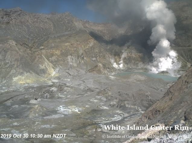 |
Figure 81. A webcam image taken at 1030 on 30 October 2019 from the crater rim shows the Whakaari/White Island crater lake to the right of the amphitheater-shaped crater and gas-and-steam plumes from active fumaroles. Courtesy of GeoNet. |
On 18 November the VAL was raised to level 2 and the Aviation Colour Code was raised to Yellow due to further increase in SO2 emissions and volcanic tremor. Other monitoring parameters showed no significant changes. On 25 November GeoNet reported that moderate volcanic unrest continued but with no new changes. Gas emissions remained high and gas-driven ejecta regularly jetting material a few meters into the air above fumaroles in the crater lake (figure 82).
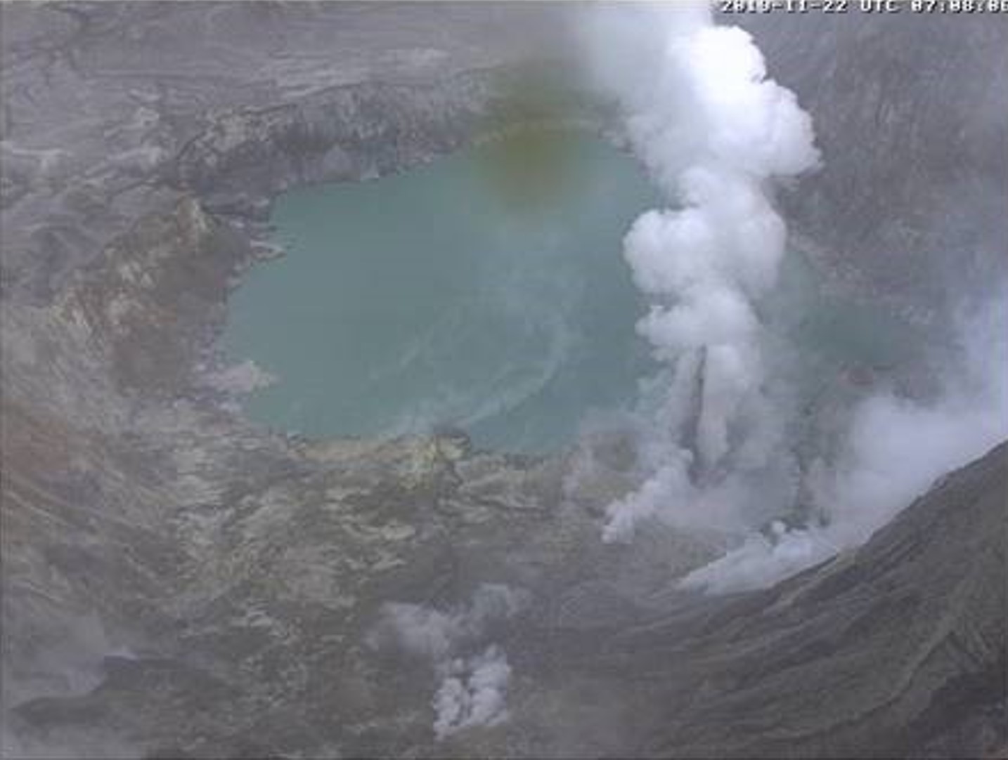 |
Figure 82. A webcam image from the Whakaari/White Island crater rim shows gas-driven ejecta rising above a fumarole within the crater lake on 22 November 2019. Courtesy of GeoNet. |
GeoNet reported on 3 December that moderate volcanic unrest continued, with increased but variable explosive gas and steam-driven jetting, with stronger events ejecting mud 20-30 m into the air and depositing mud around the vent area. Gas emissions and volcanic tremor remained elevated and occasional gas smells were reported on the North Island mainland depending on wind direction. The crater lake water level remained unchanged. Monitoring parameters were similar to those observed in 2011-2016 and remained within the expected range for moderate volcanic unrest.
Eruption on 9 December 2019. A short-lived eruption occurred at 1411 on 9 December 2019, generating a steam-and-ash plume to 3.6 km and covering the entire crater floor area with ash. Video taken by tourists on a nearby boat showed an eruption plume composed of a white steam-rich portion, and a black ash-rich ejecta (figure 83). A pyroclastic surge moved laterally across the crater floor and up the inner crater walls. Photos taken soon after the eruption showed sulfur-rich deposits across the crater floor and crater walls, and a helicopter that had been damaged and blown off the landing pad (figure 84). This activity caused the VAL to be raised to 4 (moderate volcanic eruption) and the Aviation Colour Code being raised to Orange.
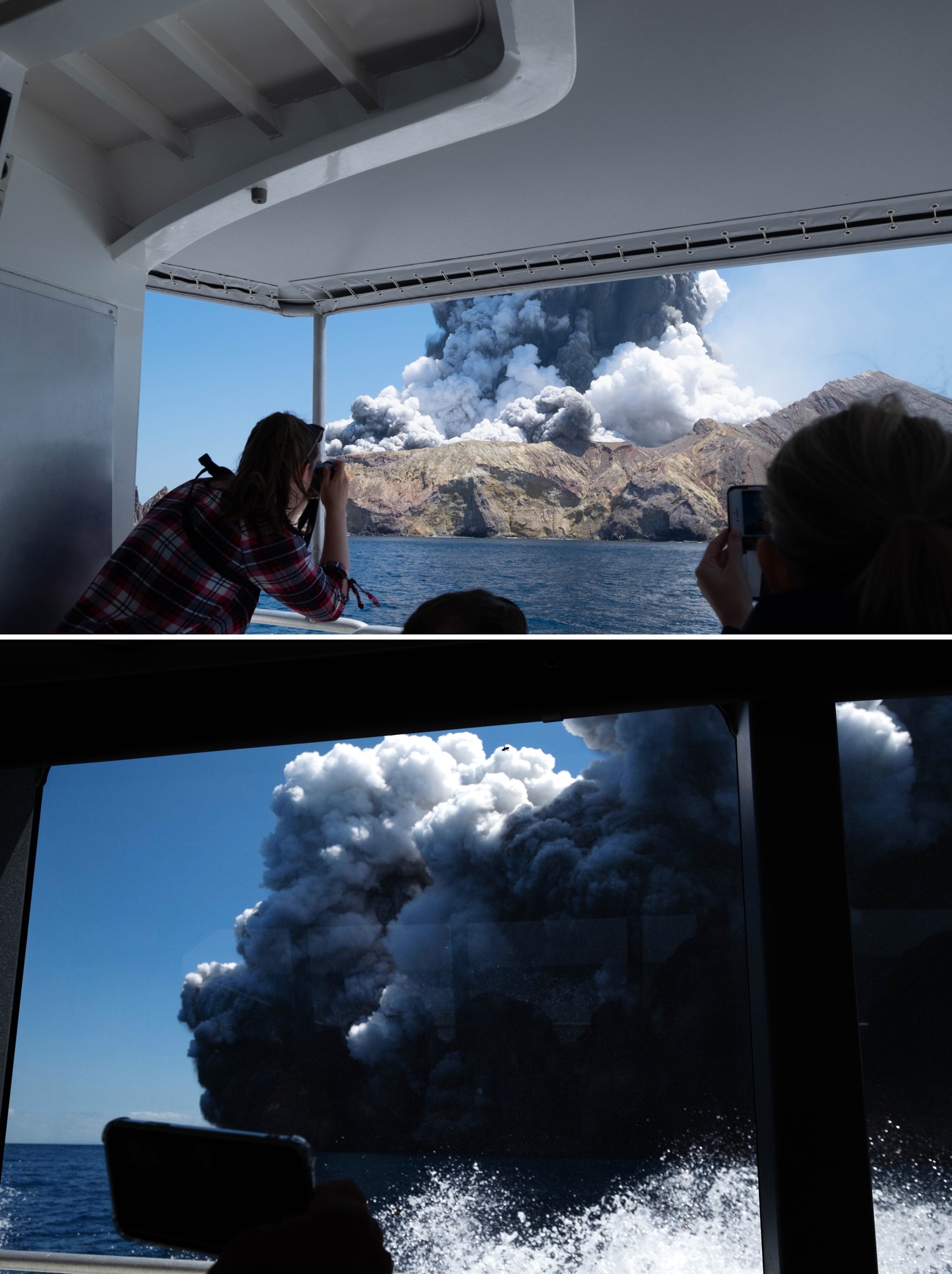 |
Figure 83. The beginning of the Whakaari/White Island 9 December 2019 eruption viewed from a boat that left the island about 20-30 minutes prior. Top: the steam-rich eruption plume rising above the volcano and a pyroclastic surge beginning to rise over the crater rim. Bottom: the expanded steam-and-ash plume of the pyroclastic surge that flowed over the crater floor to the ocean. Copyright of Michael Schade, used with permission. |
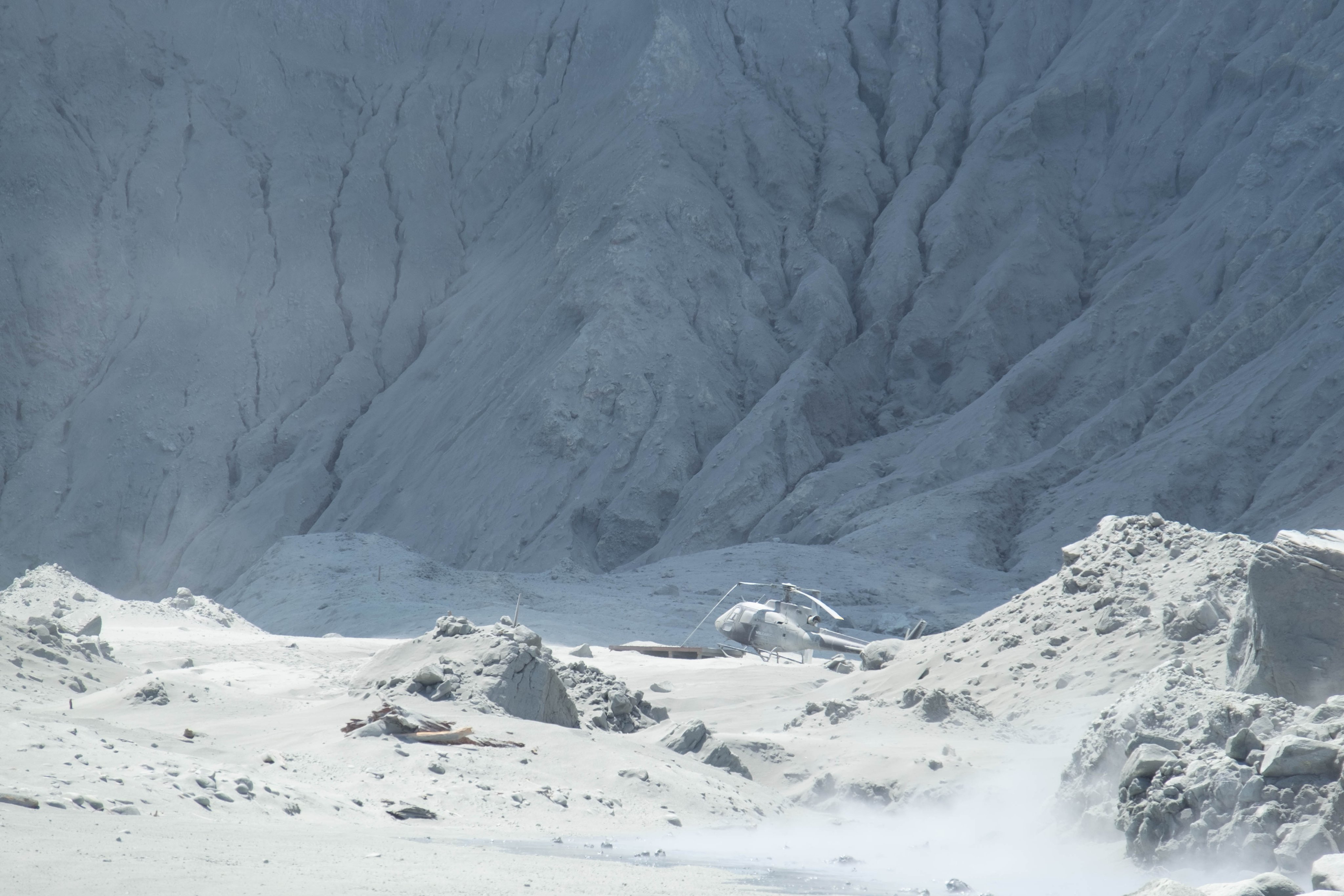 |
Figure 84. This photo of Whakaari/White Island taken after the 9 December 2019 eruption at around 1424 shows ash and sediment coating the crater floor and walls. The helicopter in this image was blown off the landing pad and damaged during the eruption. Copyright of Michael Schade, used with permission. |
A steam plume was visible in a webcam image taken at 1430 from Whakatane, 21 minutes after the explosion (figure 85). Subsequent explosions occurred at 1630 and 1749. Search-and-Rescue teams reached the island after the eruption and noted a very strong sulfur smell that was experienced through respirators. They experienced severe stinging of any exposed skin that came in contact with the gas, and were left with sensitive skin and eyes, and sore throats. Later in the afternoon the gas-and-steam plume continued and a sediment plume was dispersing from the island (figure 86). The VAL was lowered to level 3 (minor volcanic eruption) at 1625 that day; the Aviation Colour Code remained at Orange.
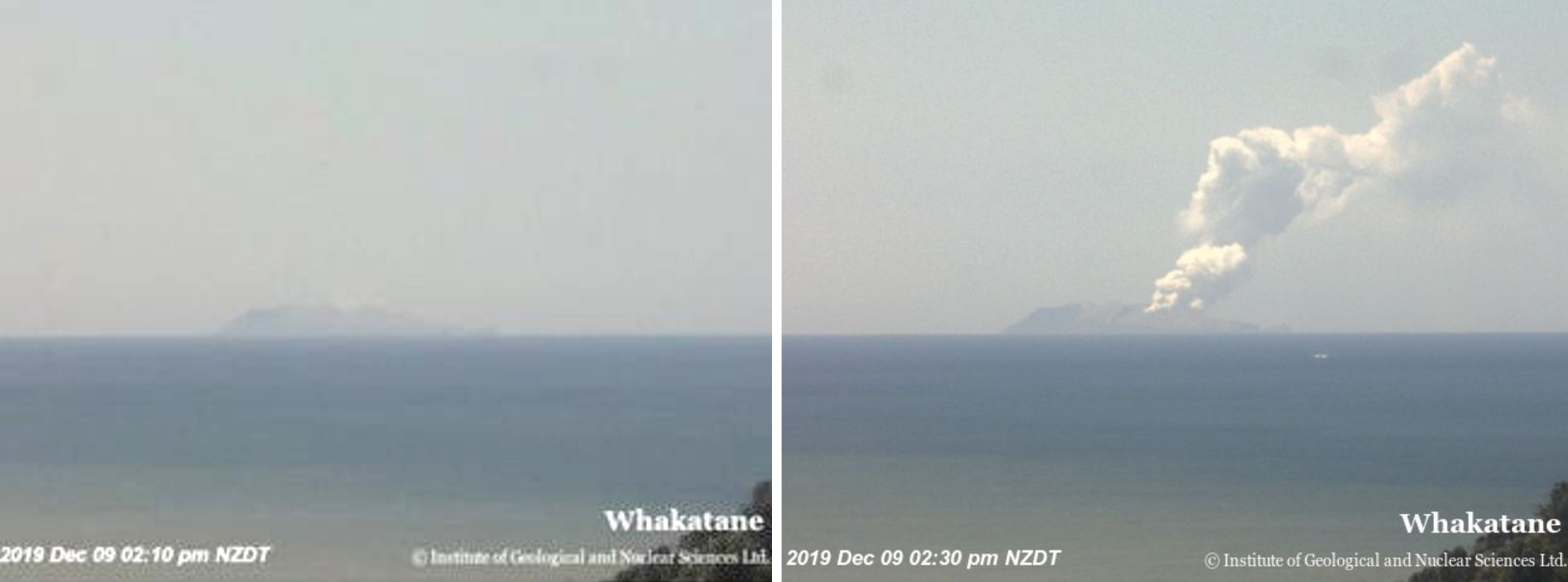 |
Figure 85. A view of Whakaari/White Island from Whakatane in the North Island of New Zealand. Left: there is no plume visible at 1410 on 9 December 2019, one minute before the eruption. Right: A gas-and-steam plume is visible 21 minutes after the eruption. Courtesy of GeoNet. |
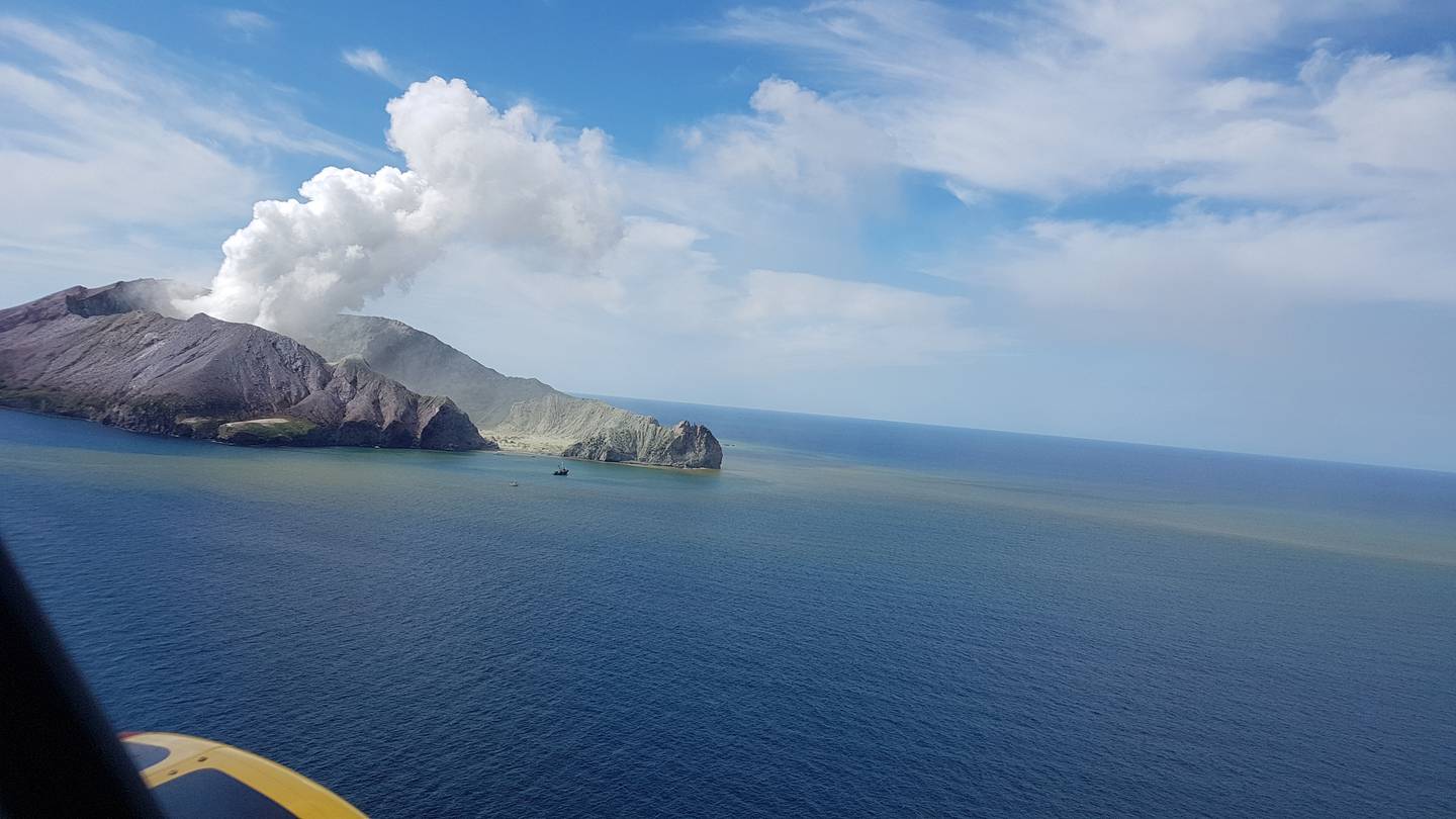 |
Figure 86. A gas-and-steam plume rises from Whakaari/White Island on the afternoon of 9 December 2019 as rescue teams visit the island. A sediment plume in the ocean is dispersing from the island. Courtesy of Auckland Rescue Helicopter Trust. |
During or immediately after the eruption an unstable portion of the SW inner crater wall, composed of 1914 landslide material, collapsed and was identified in satellite radar imagery acquired after the eruption. The material slid into the crater lake area and left a 12-m-high scarp. Movement in this area continued into early January.
Activity from late 2019 into early 2020. A significant increase in volcanic tremor began at around 0400 on 11 December (figure 87). The increase was accompanied by vigorous steaming and ejections of mud in several of the new vents. By the afternoon the tremor was at the highest level seen since the 2016 eruption, and monitoring data indicated that shallow magma was driving the increased unrest.
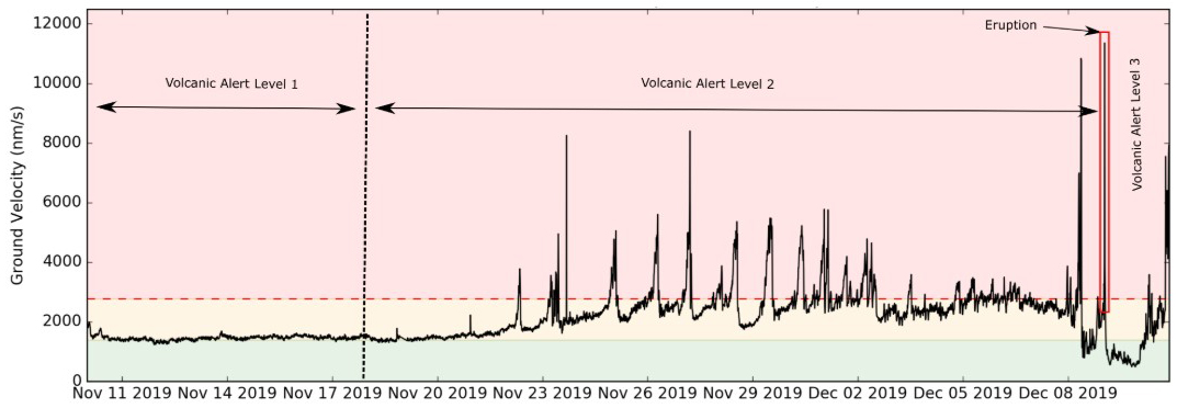 |
Figure 87. This RSAM (Real-Time Seismic Amplitude) time series plot represents the energy produced at Whakaari/White Island from 11 November to 11 December 2019 with the Volcanic Activity Levels and the 9 December eruption indicated. The plot shows the sharp increase in seismic energy during 11 December. Courtesy of GeoNet (11 December 2019 report). |
The VAL was lowered to 2 on the morning of 12 December to reflect moderate to heightened unrest as no further explosive activity had occurred since the event on the 9th. Volcanic tremor was occurring at very high levels by the time a bulletin was released at 1025 that day. Gas emissions increased since 10 January, steam and mud jetting continued, and the situation was interpreted to be highly volatile. The Aviation Colour Code remained at Orange. Risk assessment maps released that day show the high-risk areas as monitoring parameters continued to show an increased likelihood of another eruption (figure 88).
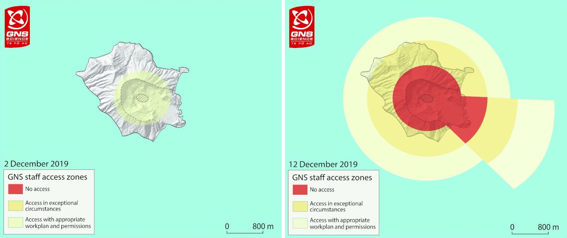 |
Figure 88. Risk assessment maps of Whakaari/White Island show the increase in high-risk areas from 2 December to 12 December 2019. Courtesy of GeoNet (12 December 2019 report). |
The volcanic activity bulletin for 13 December reported that volcanic tremor remained high, but had declined overnight. Vigorous steam and mud jetting continuing at the vent area. Brief ash emission was observed in the evening with ashfall restricted to the vent area. The 14 January bulletin reported that volcanic tremor had declined significantly over night, and nighttime webcam images showed a glow in the vent area due to high heat flow.
Aerial observations on 14 and 15 December revealed steam and gas emissions continuing from at least three open vents within a 100 m2 area (figure 89). One vent near the back of the crater area was emitting transparent, high-temperature gas that indicated that magma was near the surface, and produced a glow registered by low-light cameras (figure 90). The gas emissions had a blue tinge that indicated high SO2 content. The area that once contained the crater lake, 16 m below overflow before the eruption, was filled with debris and small isolated ponds mostly from rainfall, with different colors due to the water reacting with the eruption deposits. The gas-and-steam plume was white near the volcano but changed to a gray-brown color as it cooled and moved downwind due to the gas content (figure 91). On 15 December the tremor remained at low levels (figure 92).
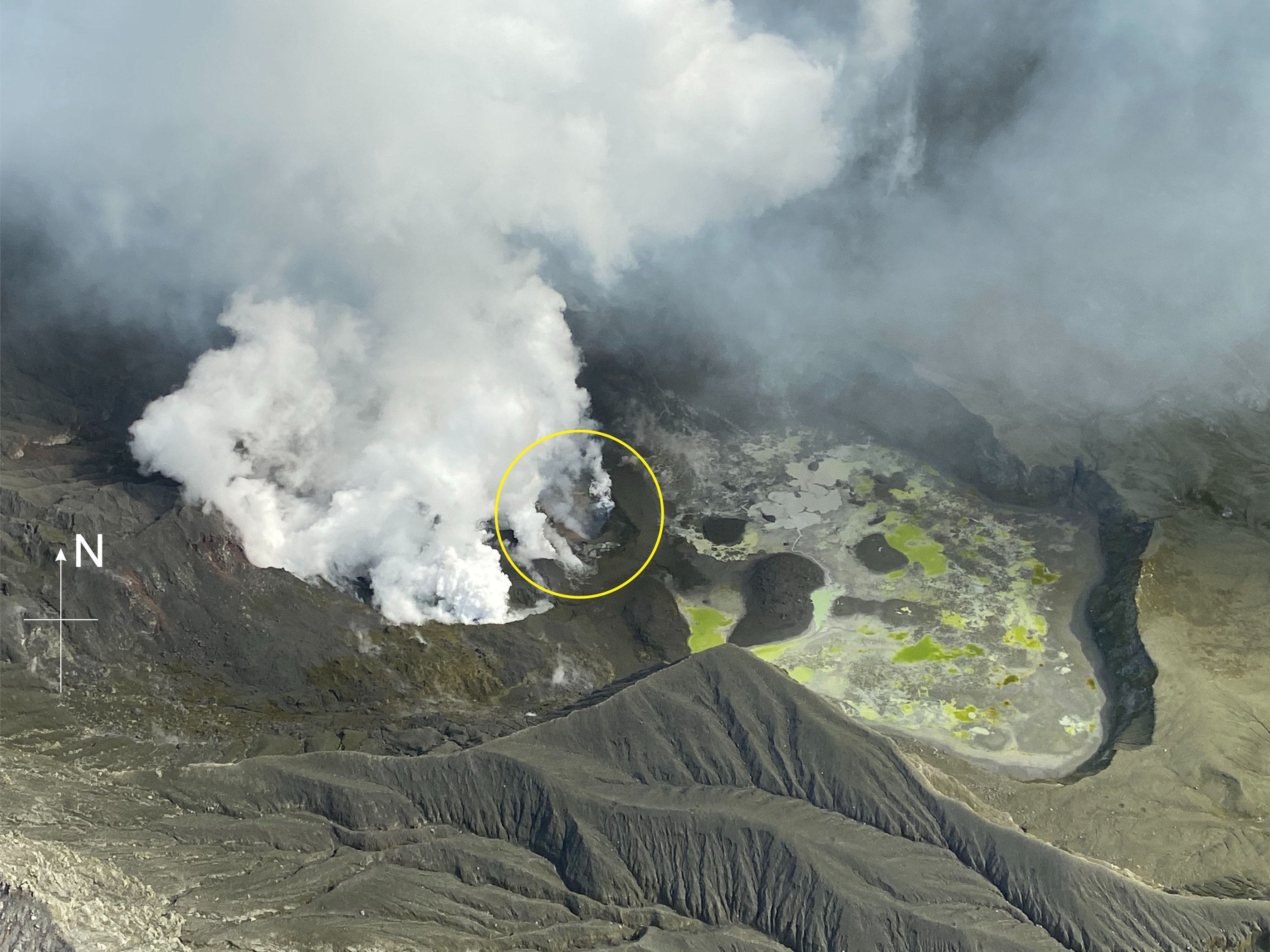 |
Figure 89. The Main Crater area of Whakaari/White Island showing the active vent area and gas-and-steam emissions on 15 December 2019. Gas emissions were high within the circled area. Before the eruption a few days earlier this area was partially filled by the crater lake. Courtesy of GeoNet (15 December 2019 report). |
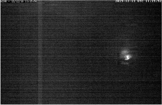 |
Figure 90. A low-light nighttime camera at Whakaari/White Island imaged "a glow" at a vent within the active crater area on 13 December 2019. This glow is due to high-temperature gas emissions and light from external sources like the moon. Courtesy of GeoNet (15 December 2019 report). |
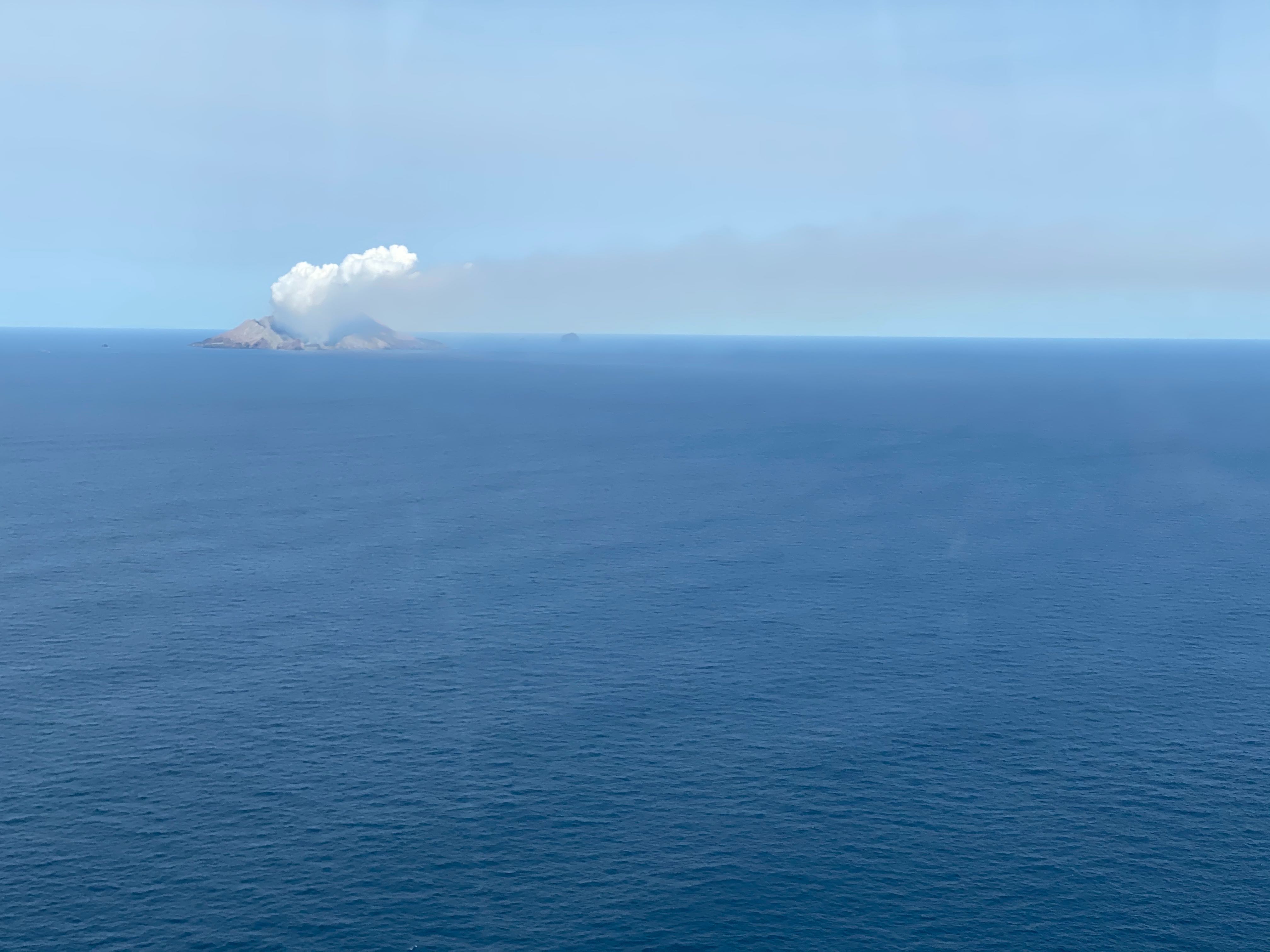 |
Figure 91. A gas-and-steam plume at Whakaari/White Island on 15 December 2019 is white near the crater and changes to a grey-brown color downwind due to the gas content. Courtesy of GeoNet (15 December 2019 report). |
 |
Figure 92. The Whakaari/White Island seismic drum plot showing the difference in activity from 12 December (top) to 15 December (bottom). Courtesy of GeoNet (15 December 2019 report). |
On 19 December tremor remained low (figure 93) and gas and steam emission continued. Overflight observations confirmed open vents with one producing temperatures over 650°C (figure 94). SO2 emissions remained high at around 15 kg/s, slightly lower than the 20 kg/s detected on 12 December. Small amounts of ash were produced on 23 and 26 December due to material entering the vents during erosion.
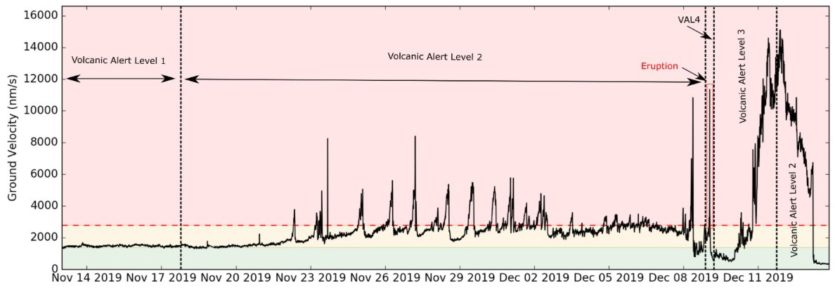 |
Figure 93. This RSAM (Real-Time Seismic Amplitude) time series plot represents the energy produced at Whakaari/White Island from 1 November to mid-December 2019. The Volcanic Alert Levels and the 9 December eruption are indicated. Courtesy of GeoNet. |
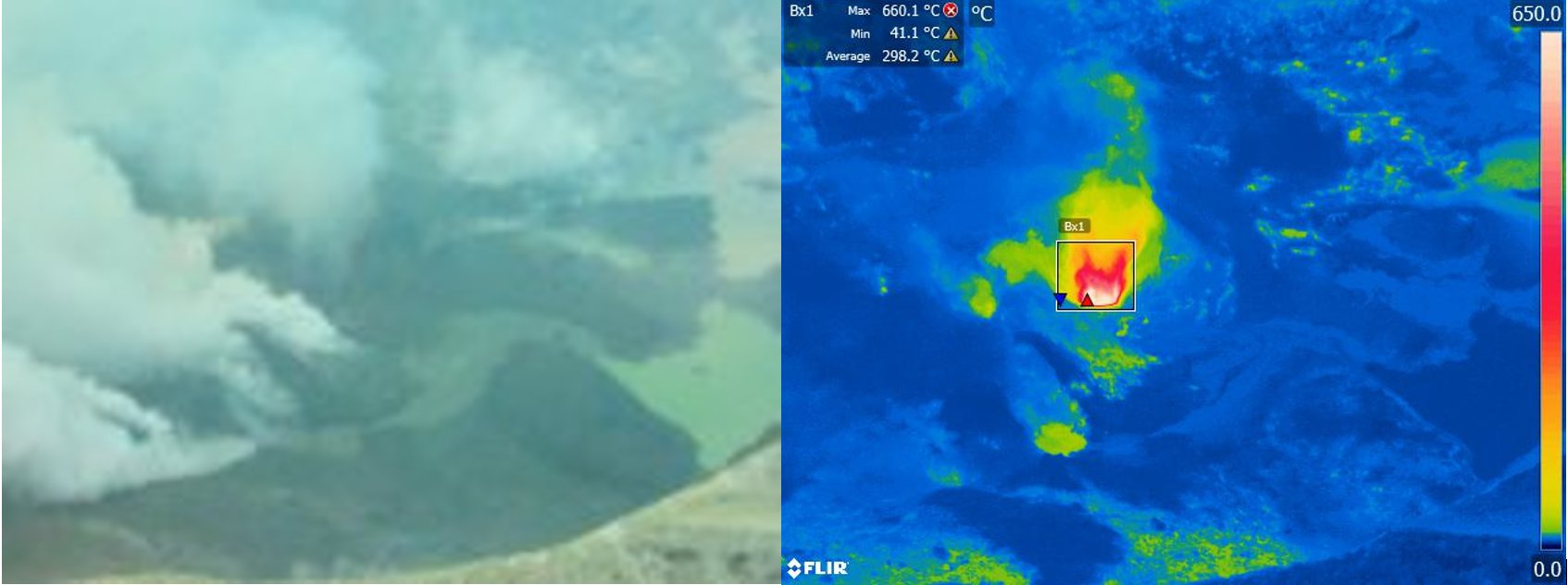 |
Figure 94. A photograph and thermal infrared image of the Whakaari/White Island crater area on 19 December 2019. The thermal imaging registered temperatures up to 650°C at a vent emitting steam and gas. Courtesy of GeoNet. |
The Aviation Colour Code was reduced to Yellow on 6 January 2020 and the VAL remained at 2. Strong gas and steam emissions continued from the vent area through early January and the glow persisted in nighttime webcam images. Short-lived episodes of volcanic tremor were recorded between 8-10 January and were accompanied by minor explosions. A 15 January bulletin reported that the temperature at the vent area remained very hot, up to 440°C, and SO2 emissions were within normal post-eruption levels.
High temperatures were detected within the vent area in Sentinel-2 thermal data on 6 and 16 January (figure 95). Lava extrusion was confirmed within the 9 December vents on 20 January. Airborne SO2 measurements on that day recorded continued high levels and the vent temperature was over 400°C. Observations on 4 February showed that no new lava extrusion had occurred, and gas fluxes were lower than two weeks ago, but still elevated. The temperatures measured in the crater were 550-570°C and no further changes to the area were observed.
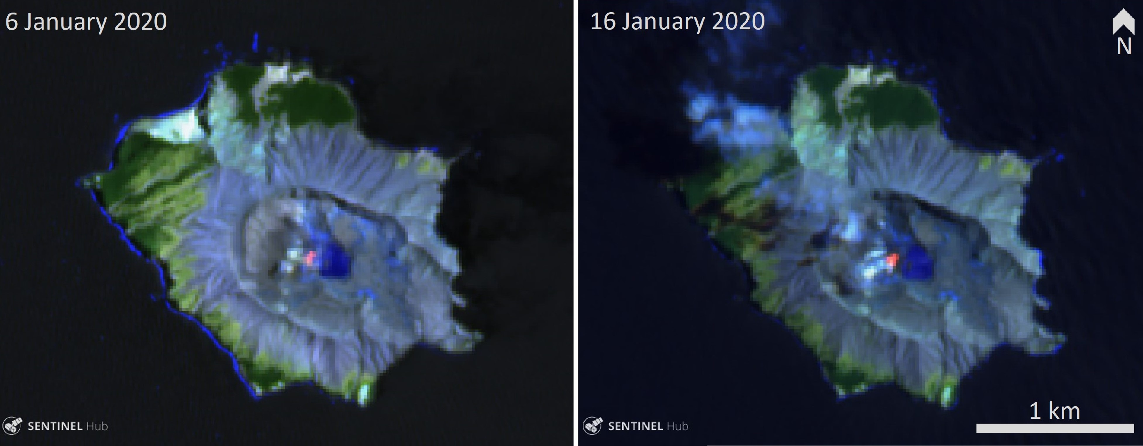 |
Figure 95. Sentinel-2 thermal infrared satellite images show elevated temperatures in the 9 December 2019 vent area on Whakaari/White Island. False color (urban) satellite image (bands 12, 11, 4) courtesy of Sentinel Hub Playground. |
Geological Summary. The uninhabited Whakaari/White Island is the 2 x 2.4 km emergent summit of a 16 x 18 km submarine volcano in the Bay of Plenty about 50 km offshore of North Island. The island consists of two overlapping andesitic-to-dacitic stratovolcanoes. The SE side of the crater is open at sea level, with the recent activity centered about 1 km from the shore close to the rear crater wall. Volckner Rocks, sea stacks that are remnants of a lava dome, lie 5 km NW. Descriptions of volcanism since 1826 have included intermittent moderate phreatic, phreatomagmatic, and Strombolian eruptions; activity there also forms a prominent part of Maori legends. The formation of many new vents during the 19th and 20th centuries caused rapid changes in crater floor topography. Collapse of the crater wall in 1914 produced a debris avalanche that buried buildings and workers at a sulfur-mining project. Explosive activity in December 2019 took place while tourists were present, resulting in many fatalities. The official government name Whakaari/White Island is a combination of the full Maori name of Te Puia o Whakaari ("The Dramatic Volcano") and White Island (referencing the constant steam plume) given by Captain James Cook in 1769.
Information Contacts: New Zealand GeoNet Project, a collaboration between the Earthquake Commission and GNS Science, Wairakei Research Centre, Private Bag 2000, Taupo 3352, New Zealand (URL: http://www.geonet.org.nz/); GNS Science, Wairakei Research Centre, Private Bag 2000, Taupo 3352, New Zealand (URL: http://www.gns.cri.nz/); Bay of Plenty Emergency Management Group Civil Defense, New Zealand (URL: http://www.bopcivildefence.govt.nz/); Auckland Rescue Helicopter Trust, Auckland, New Zealand (URL: https://www.rescuehelicopter.org.nz/); Sentinel Hub Playground (URL: https://www.sentinel-hub.com/explore/sentinel-playground); Planet Labs, Inc. (URL: https://www.planet.com/); Ben Clarke, The University of Leicester, University Road, Leicester, LE1 7RH, United Kingdom (URL: https://le.ac.uk/geology, Twitter: https://twitter.com/PyroclasticBen); Michael Schade, San Francisco, USA (URL: https://twitter.com/sch).