Report on Alaid (Russia) — December 2022
Bulletin of the Global Volcanism Network, vol. 47, no. 12 (December 2022)
Managing Editor: Edward Venzke.
Edited by Kadie L. Bennis.
Alaid (Russia) Explosions, ash plumes, and lava effusion during September-November 2022
Please cite this report as:
Global Volcanism Program, 2022. Report on Alaid (Russia) (Bennis, K.L., and Venzke, E., eds.). Bulletin of the Global Volcanism Network, 47:12. Smithsonian Institution.
Alaid
Russia
50.861°N, 155.565°E; summit elev. 2285 m
All times are local (unless otherwise noted)
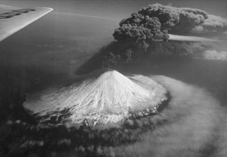
Alaid, the northernmost volcano in the Kuril Islands, has a 1.5-km-wide summit crater that is open to the S. Strong explosive eruptions have occurred from the summit crater beginning in the 18th century; explosive eruptions during 1790 and 1981 were among the largest reported in the Kuril Islands. The last eruption, during August 2018, was characterized by a small ash plume (BGVN 43:09). This report reviews a new eruption during 10 September through 26 November 2022 that consisted of Strombolian explosions, intermittent ash plumes, and lava effusion, based on weekly and daily reports from the Kamchatka Volcano Eruptions Response Team (KVERT), Tokyo VAAC (Volcanic Ash Advisory Center), and satellite data.
Strong thermal activity was detected at or near the summit during mid-September through late November 2022. According to the MODVOLC Thermal Alerts System, there were 91 hotspots detected during 1-10, 13-16, 22-23, and 25-26 October, and 25-27 November. These dates of stronger thermal anomalies were also detected in the MIROVA (Middle InfraRed Observation of Volcanic Activity) volcano hotspot detection system, which was due to the emergence of an active lava flow on the S flank (figure 10).
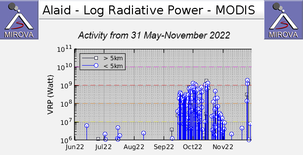 |
Figure 10. Strong thermal anomalies were detected at Alaid beginning in mid-September and continued through late November 2022, according to this MIROVA graph (Log Radiative Power). The peak of these anomalies coincides with the time during which an active lava flow was observed descending the S flank. After strong explosive activity during October, the temperature of the thermal activity gradually began to decrease in early November, though anomalies continued to be detected. The later spike in activity toward the end of November correlates with explosive activity that generated ash plumes. Courtesy of MIROVA. |
An ash plume detected in HIMAWARI-8 satellite imagery on 10 September rose to 3 km altitude (about 700 m above the summit at 2,285 m) and drifted SE, according to the Tokyo VAAC. KVERT reported that a strong thermal anomaly was detected over the volcano at 1139 on 15 September, which was considered the beginning of a Strombolian explosive eruption. A VONA (Volcano Observatory Notice for Aviation) issued on 18 September reported a gas-and-steam plume containing some ash that rose to 2.6 km altitude and drifted 32-50 km ESE, based on satellite images (figure 11). On 21 September ash plumes rose to 2.7 km altitude and drifted E and NE, based on a report from the Tokyo VAAC. During 26-27 September ash plumes rose to 3 km altitude and drifted 65-140 km ESE, NE, SE, and E. According to KVERT, a lava flow began to effuse on the S flank during 27-28 September; that flow remained active through at least 26 November, based on clear weather Sentinel-2 infrared images (figure 12).
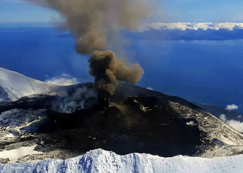 |
Figure 11. Photo of the explosive Strombolian eruption at Alaid on 18 September 2022 with a dark gray ash plume rising about 300 m above the summit and drifting E and NE. Courtesy of A. Yakimova, KVERT. |
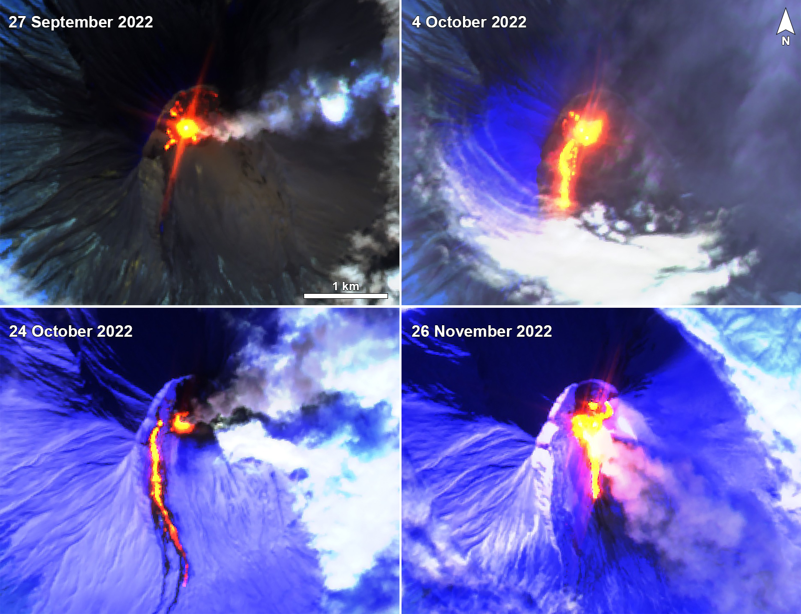 |
Figure 12. Sentinel-2 infrared satellite imagery showing a strong thermal anomaly at the summit crater of Alaid on 27 September (top left), 4 October (top right), 24 October (bottom left), and 26 November 2022 (bottom right). An active lava flow was also visible on the S flank during the latter three dates, accompanied by strong gas-and-ash plumes. Images with “Atmospheric penetration” (bands 12, 11, 8A) rendering. Courtesy of Sentinel Hub Playground. |
Strong thermal activity, intermittent explosions, and ash plumes were reported during October. An intense thermal anomaly was observed during 13-16 and 20 October when weather did not obscure the views. On 14 October ash plumes rose to 3.5 km altitude and drifted 32-343 km E and ESE. Explosive activity increased on 15 October, when ash plumes rose to 5-6.5 km altitude (4.3 km above the summit) and drifted 152-360 km E and ESE. On 16 October ash plumes rose to 3-3.7 km altitude and drifted 145-293 km ESE. Explosions on 24 October produced an ash plume that rose to 3.5 km altitude and extended 72-460 km ENE. On 26 October an ash plume rose to 3 km altitude and drifted 60-700 km E. Satellite data showed that the temperature of thermal activity began to decrease on 29 October.
During November, activity continued to gradually decrease, according to KVERT. Thermal anomalies continued to be detected occasionally throughout the month. Satellite images captured at 1025 on 26 November showed ash plumes from explosions rising to 4.5-4.7 km altitude and drifting 38 km SE. Explosions continued throughout the day; at 1521 ash plumes had risen to 3.5 km altitude and drifted as far as 220 km SE. Ground observations showed a small ash plume coming from the crater, ash deposits, and a plume rising from the S flank where the lava flow was likely contacting snow (figure 13). According to KVERT, no further ash emissions were detected after 26 November and the temperature of the thermal anomaly had decreased to background levels by 1 December.
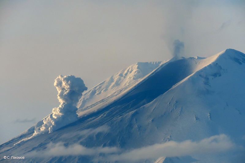 |
Figure 13. Photo of an eruption at Alaid with a small ash plume rising from the summit crater and a lava flow on the S flank on 26 November 2022. Ash deposits are visible on the snow and a larger plume from the end of the lava flow is likely due to interaction with snow. Photo has been color corrected. Courtesy of S. Lakomov, KVERT. |
Geological Summary. The highest and northernmost volcano of the Kuril Islands, Alaid is a symmetrical stratovolcano when viewed from the north, but has a 1.5-km-wide summit crater that is breached open to the south. This basaltic to basaltic andesite volcano is the northernmost of a chain constructed west of the main Kuril archipelago. Numerous pyroclastic cones are present the lower flanks, particularly on the NW and SE sides, including an offshore cone formed during the 1933-34 eruption. Strong explosive eruptions have occurred from the summit crater beginning in the 18th century. Reports of eruptions in 1770, 1789, 1821, 1829, 1843, 1848, and 1858 were considered incorrect by Gorshkov (1970). Explosive eruptions in 1790 and 1981 were among the largest reported in the Kuril Islands.
Information Contacts: Kamchatka Volcanic Eruptions Response Team (KVERT), Far Eastern Branch, Russian Academy of Sciences, 9 Piip Blvd., Petropavlovsk-Kamchatsky, 683006, Russia (URL: http://www.kscnet.ru/ivs/kvert/); Tokyo Volcanic Ash Advisory Center (VAAC), 1-3-4 Otemachi, Chiyoda-ku, Tokyo 100-8122, Japan (URL: http://ds.data.jma.go.jp/svd/vaac/data/); MIROVA (Middle InfraRed Observation of Volcanic Activity), a collaborative project between the Universities of Turin and Florence (Italy) supported by the Centre for Volcanic Risk of the Italian Civil Protection Department (URL: http://www.mirovaweb.it/); Hawai'i Institute of Geophysics and Planetology (HIGP) - MODVOLC Thermal Alerts System, School of Ocean and Earth Science and Technology (SOEST), Univ. of Hawai'i, 2525 Correa Road, Honolulu, HI 96822, USA (URL: http://modis.higp.hawaii.edu/); Sentinel Hub Playground (URL: https://www.sentinel-hub.com/explore/sentinel-playground).