Report on Popocatepetl (Mexico) — December 2022

Bulletin of the Global Volcanism Network, vol. 47, no. 12 (December 2022)
Managing Editor: Edward Venzke.
Edited by Kadie L. Bennis.
Popocatepetl (Mexico) Daily gas-and-ash plumes, intermittent explosions, and ashfall during August-November 2022
Please cite this report as:
Global Volcanism Program, 2022. Report on Popocatepetl (Mexico) (Bennis, K.L., and Venzke, E., eds.). Bulletin of the Global Volcanism Network, 47:12. Smithsonian Institution.
Popocatepetl
Mexico
19.023°N, 98.622°W; summit elev. 5393 m
All times are local (unless otherwise noted)
Popocatépetl, located 70 km SE of Mexico City, Mexico, contains a 400 x 600 m wide summit crater. Records of activity date back to the 14th century, with the most recent eruption period beginning in January 2005, characterized by numerous episodes of lava dome growth and destruction within the summit caldera. Current activity has consisted of occasional explosions and daily gas-and-steam emissions (BGVN 47:09). This report updates activity from August through November 2022, which included daily gas-and-ash plumes, intermittent explosions, and light ashfall in nearby towns, based on information from México's Centro Nacional de Prevención de Desastres (CENAPRED) and various satellite data.
Daily gas-and-steam emissions, some of which contained ash, continued during August through November 2022. CENAPRED reported the number of low-intensity gas-and-ash emissions or “exhalations” and the number of minutes in their daily reports (figure 199). A total of 50 volcano-tectonic (VT) tremors were detected throughout the reporting period. The average number of gas-and-ash emissions was 69 per day, with a maximum of 215 on 23 October 2022. Frequent sulfur dioxide plumes were visible in satellite data from the TROPOMI instrument on the Sentinel-5P satellite (figure 200).
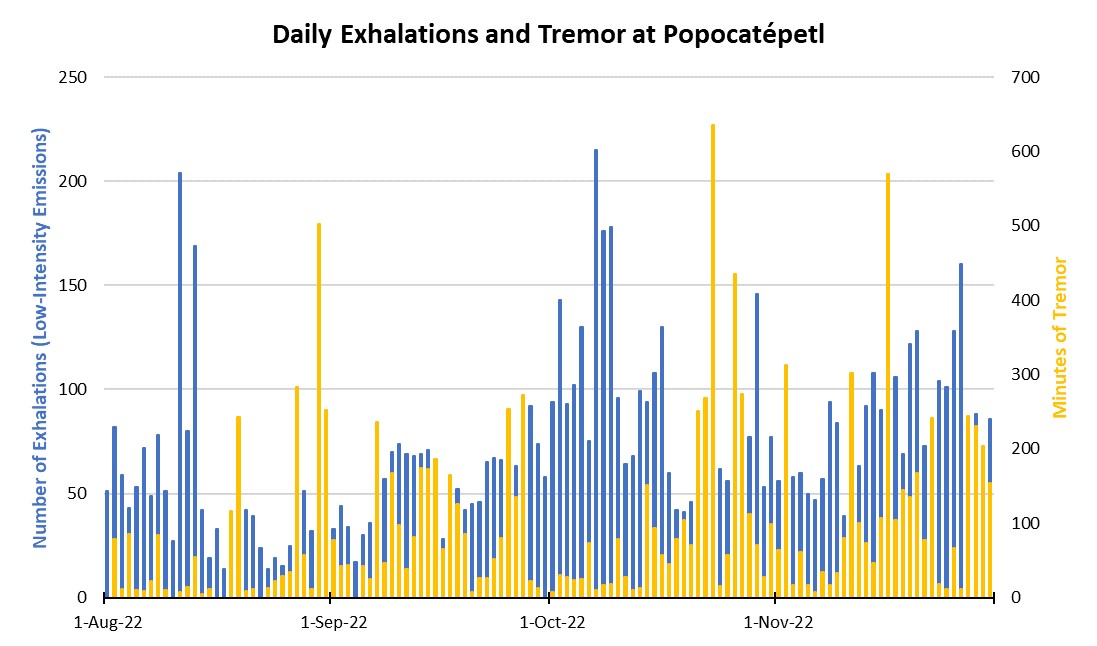 |
Figure 199. Graph showing the number of daily “exhalations” (in blue, left scale), and the number of minutes of tremor (in gold, right scale) at Popocatépetl each day during August through November 2022. The maximum number of daily exhalations was 215 on 7 October 2022; the maximum duration of 635 minutes of tremor was detected on 23 October 2022. Data from CENAPRED daily reports. |
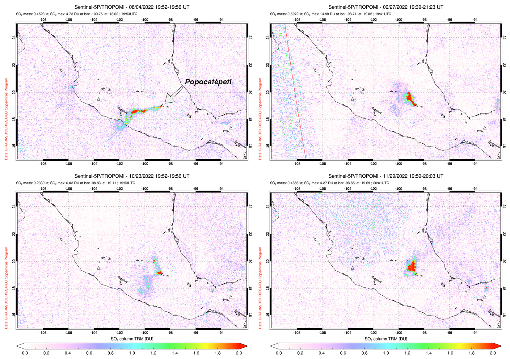 |
Figure 200. Sulfur dioxide plumes were detected at Popocatépetl and drifted generally W and NW, as shown on 4 August 2022 (top left), 27 September 2022 (top right), 23 October 2022 (bottom left), and 29 November 2022 (bottom right). Courtesy of NASA Global Sulfur Dioxide Monitoring Page. |
Activity during August mostly consisted of daily gas-and-steam and ash emissions, with four explosions recorded and 13 VT-type events detected. An average of 50 exhalations occurred each day, which included mostly water vapor, volcanic gases, and a small amount of ash. On 10 August a minor explosion was detected at 0839 (figure 201) and on 11 August a moderate explosion was detected at 1528, which caused light ashfall in Ecatzingo (15 km SW). An explosion at 1952 on 13 August caused minor ashfall in Tetela del Volcán (15 km SW). A moderate explosion was detected at 0117 on 30 August.
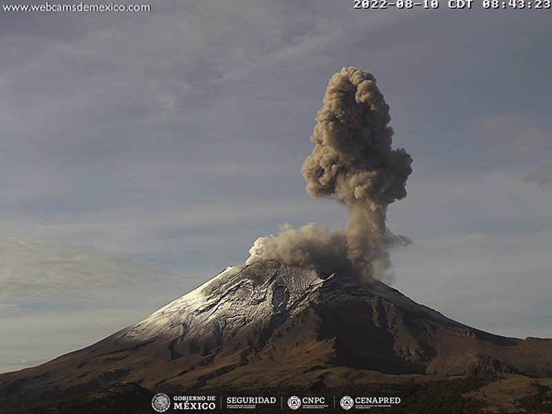 |
Figure 201. Webcam image of a gray-brown ash plume that rose above Popocatépetl at 0843 on 10 August 2022. Courtesy of CENAPRED daily report. |
Similar activity persisted during September with daily gas-and-steam and ash emissions, occasional tremor events, and explosions though cloudy weather would obscure clear views of the summit. There were 10 VT-type events that were recorded during the month and an average of 55 daily exhalations were reported. Explosions were detected at 2121 on 7 September and at 1418 on 8 September, though the latter could not be observed due to cloudy weather. On 9 September an explosion was detected at 0611 and the National Center for Communications and Civil Protection Operations (CENACOM) reported light ashfall in Atlixco, Puebla (23 km SE); on 10 September light ashfall was reported in Ecatzingo. A minor explosion was recorded at 0714 on 15 September. CENAPRED reported three minor explosions on 20 September (at 1939, 1942, and 2254), seven on 21 September (at 0417, 0448, 0717, 0756, 1333, 1708, and 1842), one on 22 September (at 0444), and one on 23 September (at 0456). On 25 September a minor explosion was detected at 2047, and two explosions occurred on 27 September (at 0454 and 0509). During the night of 27 September crater incandescence was observed, accompanied by gas-and-ash emissions that drifted NW. During 28-29 September light ashfall was reported in Tláhuac, Xochimilco (56 km NW), Milpa Alta (45 km NW), and part of Iztapalapa (57 km NW). A minor explosion occurred at 0226 on 29 September.
During October, daily gas-and-steam and ash emissions continued with occasional tremor events. There were 16 VT-type events recorded throughout the month, in addition to an average of 90 daily exhalations. On 6 October a moderate explosion was accompanied by incandescent material moving down the N slope. According to a news article, a new small lava dome appeared on the crater floor on 7 October and continued to grow at a rate of 2 m3/s through 19 October; measurements showed that the diameter of the dome was approximately 60 m. Two minor explosions were recorded at 1138 and 1635 on 8 October. A minor explosion was reported at 0039 on 25 October. During 25-26 October CENACOM reported light ashfall in Atlautla (16 km W).
Activity during November consisted of daily gas-and-steam and ash emissions with tremor events and intermittent explosions. There were 11 VT-type events detected and an average of 81 daily exhalations. A total of 12 minor explosions were recorded during 9-12 November: one at 2152 on 9 November, four on 10 November (at 1337, 1625, 1629, and 2026), four on 11 November (at 0141, 1109, 1223, and 1519), and three on 12 November (at 0919, 1933, and 2057). Light ashfall was reported in Tochimilco (15 km SSE) during 10 November. Fifteen minor explosions were reported during 13-19 November at 1302 on 13 November, four on 14 November (at 0131, 0615, 1459, and 2330), at 0710 on 15 November, two on 16 November (at 0723 and 1102), four on 17 November (at 0244, 1140, 1754, and 1827), one on 18 November (at 0116), and two on 19 November (at 1902 and 1926). A minor explosion at 0050 on 22 November ejected incandescent material above the crater rim and onto nearby flanks (figure 202). A total of three minor explosions were reported at 1543 on 25 November and at 0535 and 0915 on 26 November that generated ash plumes that rose 2 km above the summit and drifted NE. Three more minor explosions were detected at 1101, 1233, and 2353 on 26 November.
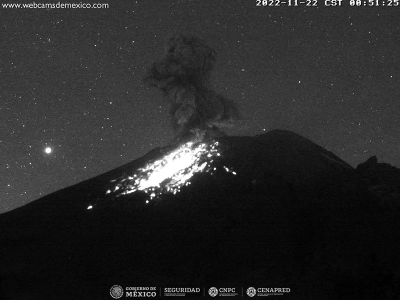 |
Figure 202. Webcam image of a minor explosion at Popocatépetl at 0051 on 22 November 2022, which ejected incandescent material on the nearby flanks and was accompanied by an ash plume. Courtesy of CENAPRED daily report. |
MODIS thermal anomaly data provided through MIROVA (Middle InfraRed Observation of Volcanic Activity) showed mostly intermittent moderate-power thermal activity during August through November, with an increase in frequency beginning in early October (figure 203). According to data from MODVOLC thermal alerts, a total of nine hotspots were detected at the summit crater on 9 and 23 September, 7 and 23 October, and 17, 19, and 28 November. Some of these hotspots were also visible in the summit crater in infrared satellite data from Sentinel-2 and on 23 October it was accompanied by an ash plume (figure 204).
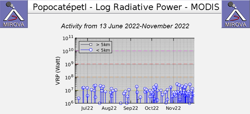 |
Figure 203. The MIROVA graph of thermal anomalies at Popocatépetl from 13 June 2022 through November 2022 showing intermittent moderate thermal activity. The frequency of thermal activity increased briefly during early October and again during late October. Courtesy of MIROVA. |
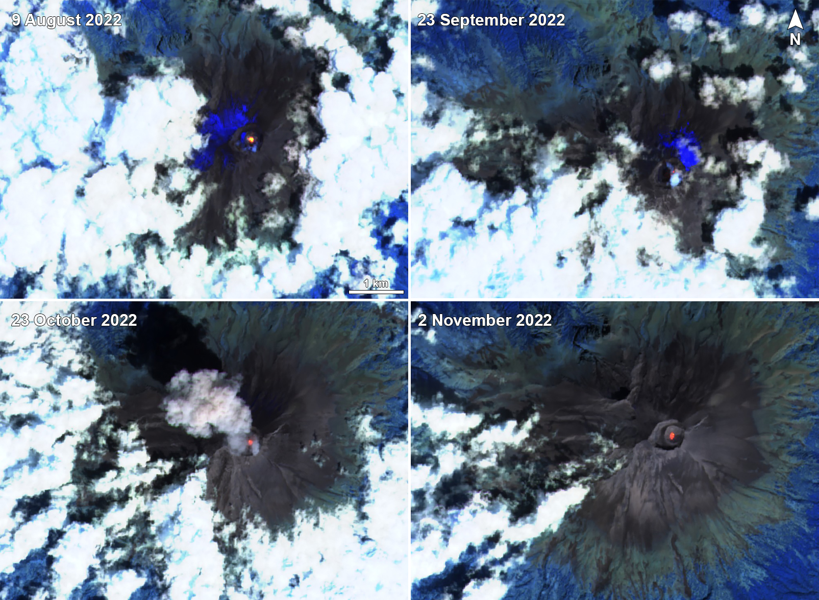 |
Figure 204. Sentinel-2 infrared satellite images showing a persistent thermal anomaly in the summit crater of Popocatépetl on 9 August 2022 (top left), 23 September 2022 (top right), 23 October 2022 (bottom left), and 2 November 2022 (bottom right). A strong ash plume was visible accompanying the thermal activity on 23 October. Courtesy of Sentinel Hub Playground. |
Geological Summary. Volcán Popocatépetl, whose name is the Aztec word for smoking mountain, rises 70 km SE of Mexico City to form North America's 2nd-highest volcano. The glacier-clad stratovolcano contains a steep-walled, 400 x 600 m wide crater. The generally symmetrical volcano is modified by the sharp-peaked Ventorrillo on the NW, a remnant of an earlier volcano. At least three previous major cones were destroyed by gravitational failure during the Pleistocene, producing massive debris-avalanche deposits covering broad areas to the south. The modern volcano was constructed south of the late-Pleistocene to Holocene El Fraile cone. Three major Plinian eruptions, the most recent of which took place about 800 CE, have occurred since the mid-Holocene, accompanied by pyroclastic flows and voluminous lahars that swept basins below the volcano. Frequent historical eruptions, first recorded in Aztec codices, have occurred since Pre-Columbian time.
Information Contacts: Centro Nacional de Prevención de Desastres (CENAPRED), Av. Delfín Madrigal No.665. Coyoacan, México D.F. 04360, México (URL: http://www.cenapred.unam.mx/, Daily Report Archive https://www.gob.mx/cenapred/archivo/articulos); MIROVA (Middle InfraRed Observation of Volcanic Activity), a collaborative project between the Universities of Turin and Florence (Italy) supported by the Centre for Volcanic Risk of the Italian Civil Protection Department (URL: http://www.mirovaweb.it/); Hawai'i Institute of Geophysics and Planetology (HIGP) - MODVOLC Thermal Alerts System, School of Ocean and Earth Science and Technology (SOEST), Univ. of Hawai'i, 2525 Correa Road, Honolulu, HI 96822, USA (URL: http://modis.higp.hawaii.edu/); NASA Global Sulfur Dioxide Monitoring Page, Atmospheric Chemistry and Dynamics Laboratory, NASA Goddard Space Flight Center (NASA/GSFC), 8800 Greenbelt Road, Goddard, Maryland, USA (URL: https://so2.gsfc.nasa.gov/); Sentinel Hub Playground (URL: https://www.sentinel-hub.com/explore/sentinel-playground); Tribuna Noticias, Detectan crecimiento de un domo en el volcán Popocatépetl, San Martín Texmelucan No. 68 Col. La Paz, Puebla, Mexico (URL: https://tribunanoticias.mx/detectan-crecimiento-de-un-domo-en-el-volcan-popocatepetl/).