Report on Cotopaxi (Ecuador) — February 2023

Bulletin of the Global Volcanism Network, vol. 48, no. 2 (February 2023)
Managing Editor: Edward Venzke.
Edited by Kadie L. Bennis.
Cotopaxi (Ecuador) New eruption in October 2022; frequent ash emissions continuing through January 2023
Please cite this report as:
Global Volcanism Program, 2023. Report on Cotopaxi (Ecuador) (Bennis, K.L., and Venzke, E., eds.). Bulletin of the Global Volcanism Network, 48:2. Smithsonian Institution.
Cotopaxi
Ecuador
0.677°S, 78.436°W; summit elev. 5911 m
All times are local (unless otherwise noted)
Cotopaxi, located in Ecuador, is a steep-sided cone capped by nested summit craters, the largest of which is about 550 x 800 m. Pyroclastic flows have accompanied many explosive eruptions and lahars have frequently affected adjacent valleys. Strong eruptions took place in 1744, 1768, and 1877. The most recent eruption took place during August 2015 through January 2016 that was characterized by phreatic explosions, ash plumes, pyroclastic flows, lahars, and ash fall (BGVN 41:05). A new eruption began in October 2022; this report describes activity from October 2022 through January 2023, which included frequent ash plumes, ashfall, and rare lahars. Information comes from Ecuador's Instituto Geofísico, Escuela Politécnica Nacional (IG-EPN), Servicio Nacional de Gestión de Riesgos y Emergencias (SNGRE), the Washington Volcanic Ash Advisory Center (VAAC), and various satellite data.
Activity has been relatively quiet since the last eruption in January 2016. According to the Washington VAAC, four ash clouds were detected on 4 July 2016, 23 January 2017, 15 July 2018, and 10 January 2020. However, no seismicity or ash deposits were associated with these events, so their cause is unknown and has not been attributed to eruptive activity.
During 21-31 October gas-and-steam emissions rose 200-1,000 m above the crater and seismicity was mainly characterized by daily small, long-period (LP) type earthquakes, volcano-tectonic (VT) events, and volcanic tremor (TR). On 21 October at 1944 seismic stations on the flanks began to record a volcanic tremor event. This earthquake signal lasted until 0040 on 22 October and was accompanied by gas-and-ash emissions that drifted NE; a moderate amount of ashfall was visible in the Refugio José Rivas, 2 km N of the summit crater, in addition to a sulfur odor (figure 19). The Washington VAAC reported a diffuse ash cloud seen in GOES-16 satellite imagery at 2200 on 21 October that rose to 1.7-2.3 km above the crater and drifted NE and W. A Sentinel-2 satellite image showed ash deposits on the N flank on 23 October (figure 20). Seismic stations on the N flank detected a signal related to small lahars during 1115-1300 on 23 October, which were generated due to a melted glacier underlying the ash deposit. An analysis of ash samples collected by IG scientists at the Refugio José Rivas showed that about 22% was juvenile material.
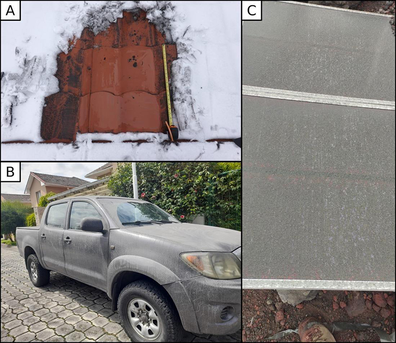 |
Figure 19. Photos of ash deposits from the eruption at Cotopaxi on 21 October 2022. Photos by Benjamin Bernard, IG-EPN (A), Cristian Rivera, ASEGUIM (B), and Marco Solís, IG-EPN (C). Courtesy of IG-EPN. |
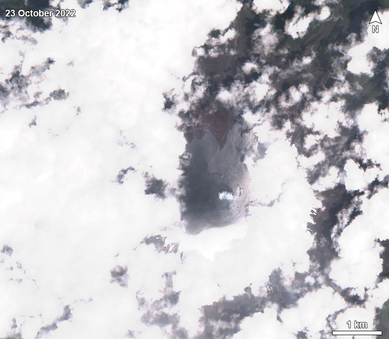 |
Figure 20. Sentinel-2 satellite image showing ashfall deposits on the N flank of Cotopaxi on 23 October 2022. Image uses “Natural color” rendering (bands 4, 3, 2). Courtesy of Sentinel Hub Playground. |
During November, frequent gas-and-steam emissions rose 200-2,800 above the crater and seismicity mostly consisted of daily small LP events and occasional TR and VT events. During 23-24 November ash emissions rose 200-1,000 m above the crater and drifted E, causing visible ash deposits on the NE flank. A new episode of tremor associated with gas-and-ash emissions was detected at approximately 0310 on 26 November that lasted for several hours (figure 21). An ash plume rose 2.2 km above the crater on 26 November and extended 60-85 km NNW. Ashfall was visible in various sectors in the Mejía, Rumiñahui, and Quito areas, including El Pedregal (60 km N), Tambillo (32 km NNW), Guamaní (42 km NNW), Amaguaña (33 km NNW), Chillogallo (44 km NNW), Quitumbe (41 km NNW), Solanda (46 km NNW), Lloa (48 km NNW), Conocoto (41 km N), Mercado Mayorista (45 km NNW), Villaflora (47 km NNW), and Rumipamba (55 km N); an estimated 7-20 x 106 kg of ash were measured. On 27 November gas-and-steam emissions rose 2.8 km above the summit. The Washington VAAC reported during 26-27 November gas-and-ash emissions rose 1.7 km above the summit and drifted NW. Ash emissions rose 600 m above the crater and drifted E on 30 November. IG noted that light ashfall in Latacunga and on the S flank may have been due to remobilization of previously erupted ash.
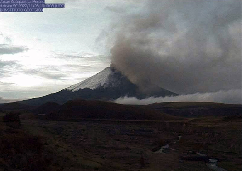 |
Figure 21. Webcam image of a gas-and-ash plume rising above Cotopaxi on 26 November 2022. Photo has been color corrected. Courtesy of IG (INFORME DIARIO DEL VOLCAN COTOPAXI No. 2022-036). |
Seismicity consisting of frequent LP, VT, and TR events continued to be detected during December, occasionally accompanied by gas-and-steam emissions that rose 200-2,000 above the crater. Between 0758 and 0816 on 8 December ash plumes rose approximately 1 km above the summit and drifted WNW; there were no reports of ashfall. During 9-10 December gas-and-ash emissions rose 1.1 km above the crater and drifted NW, causing minor ashfall in Conocoto-Pichincha. A gas-and-ash plume during 10-11 December rose 2 km above the crater and drifted W and NW; there were reports of ashfall at the S area of the Cotopaxi National Park. During 14-15 December gas-and-ash plumes rose 500 m above the crater and drifted W, causing moderate ashfall in the Cotopaxi National Park. During 19-20 December the Washington VAAC reported ash emissions to 1.1 km above the crater that drifted N and NW (figure 22), which caused ashfall in San Pedro de Taboada (40 km N), Uyumbicho (30 km NNW), Guitig Alta, Guitig Baja, Conocoto, Sur de Quito, Chimbacalle (48 km NNW), La Magdalena (48 km NNW), Barrio Nuevo, Villaflora, Miraflores, and La Floresta (50 km N). IG also reported an ash plume to 1.5 km above the crater that drifted 60 km NNW, resulting in ashfall in the Mejía, Rumiñahui, and Quito areas on 20 December. During 21-22 December gas-and-ash emissions rose 500 m above the crater and drifted SE, E, and W; ashfall was reported at Caspi, the S entrance to the national park.
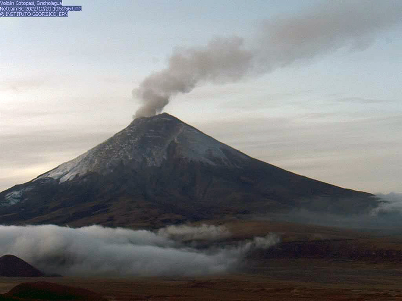 |
Figure 22. Webcam image showing a gas-and-ash plume rising above Cotopaxi on 20 December 2022. Photo has been color corrected. Courtesy of IG (INFORME DIARIO DEL VOLCAN COTOPAXI No. 2022-060). |
Near daily gas-and-steam emissions continued to be reported during January 2023, rising 500-1,000 m above the crater. Seismicity continued with frequent LP and TR events and occasional VT events. The Washington VAAC reported ash emissions that rose 200-2,000 m above the crater and drifted in multiple directions. During 5-6 January a GOES 16 satellite image acquired at 0500 showed a diffuse ash cloud 1 km above the crater that drifted NW; minor ashfall was observed over national park. During 9-13 January the Washington VAAC reported ash emissions rising as high as 2 km above the crater and drifting NW, SW, and W; reports of ashfall came from Colcas, San Ramón, San Agustín de Callo, Mulaló, Mulaló Grande, San Antonio, San Ramón (127 km W), Ticatilin (15 km SW), and MAE Norte, 18 km N of the volcano. Additionally, a sulfur odor was reported during 11-12 December in the towns of Ticatilín and Control Caspi (20 km WSW). During 16-19, 25-27, and 29-30 January light ashfall was reported in Mulaló, San Juan de Pastocalle (20 km WSW), Aláquez, San Agustín de Callo (18 km WSW), Villacís, Ticatilín, Caspi, San Ramon, Chillos (33 km SW), Langualó, San Isidro Alto (20 km SW), and on the N side of the national park. A significant increase in size and density of ash emissions was visible in satellite images at 0820 on 30 January; the plumes rose as high as 2.5 km above the crater rim and drifted SW, S, and SE (figure 23).
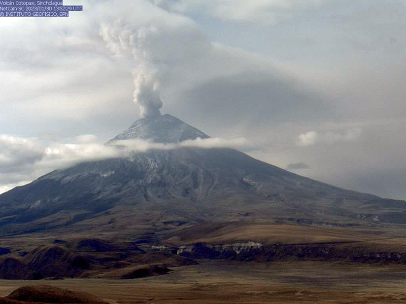 |
Figure 23. Webcam image showing a strong ash plume that rose above Cotopaxi on 30 January 2023 and drifted SE. Courtesy of IG (INFORME DIARIO DEL VOLCAN COTOPAXI No. 2023-030). |
Additional satellite data. Scientists measured sulfur dioxide emissions using a mobile Differential Optical Absorption Spectroscopy (DOAS) instrument on 22 October; emissions were 1,580 tons/day (t/d). Using Sentinel-5P TROPOMI data process by the MOUNTS system, and the DOAS network, IG noted increased degassing beginning on 5 November with sulfur dioxide emissions ranging from 94 tons to 3,493 tons, the latter of which was measured on 26 November. During December levels of sulfur dioxide fluctuated between 119 and 5,753 tons, the latter of which was measured on 25 December. Similar variation was seen in January, with SO2 values measured between 2 tons and 4,718 tons, with the maximum on 8 January. Sentinel-2 infrared satellite images showed a small thermal anomaly at the summit crater on four clear days on 23 October and 2, 17, and 22 December (figure 24).
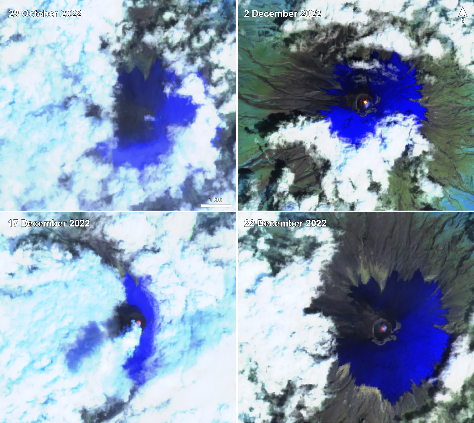 |
Figure 24. Sentinel-2 infrared satellite imagery showing a small thermal anomaly at the summit crater of Cotopaxi on 23 October 2022 (top left), 2 December 2022 (top right), 17 December 2022 (bottom left), and 22 December 2022 (bottom right). Images using “Atmospheric penetration” (bands 12, 11, 8A) rendering. Courtesy of Sentinel Hub Playground. |
Geological Summary. The symmetrical, glacier-covered, Cotopaxi stratovolcano is Ecuador's most well-known volcano and one of its most active. The steep-sided cone is capped by nested summit craters, the largest of which is about 550 x 800 m in diameter. Deep valleys scoured by lahars radiate from the summit of the andesitic volcano, and large andesitic lava flows extend to its base. The modern edifice has been constructed since a major collapse sometime prior to about 5,000 years ago. Pyroclastic flows (often confused in historical accounts with lava flows) have accompanied many explosive eruptions, and lahars have frequently devastated adjacent valleys. Strong eruptions took place in 1744, 1768, and 1877. Pyroclastic flows descended all sides of the volcano in 1877, and lahars traveled more than 100 km into the Pacific Ocean and western Amazon basin. Smaller eruptions have been frequent since that time.
Information Contacts: Instituto Geofísico, Escuela Politécnica Nacional (IG-EPN), Casilla 17-01-2759, Quito, Ecuador (URL: http://www.igepn.edu.ec/); Servicio Nacional de Gestion de Riesgos y Emergencias (SNGRE), Samborondón, Ecuador (URL: https://www.gestionderiesgos.gob.ec/); Washington Volcanic Ash Advisory Center (VAAC), Satellite Analysis Branch (SAB), NOAA/NESDIS OSPO, NOAA Science Center Room 401, 5200 Auth Rd, Camp Springs, MD 20746, USA (URL: www.ospo.noaa.gov/Products/atmosphere/vaac, archive at: http://www.ssd.noaa.gov/VAAC/archive.html); MOUNTS Project (Monitoring Unrest From Space), an operational monitoring system for volcanoes using Sentinel satellite data from ESA's Copernicus, Open Access Hub, hosted at UNAM and CT TU-Berlin (URL: http://www.mounts-project.com/home); Sentinel Hub Playground (URL: https://www.sentinel-hub.com/explore/sentinel-playground).