Report on East Epi (Vanuatu) — March 2023
Bulletin of the Global Volcanism Network, vol. 48, no. 3 (March 2023)
Managing Editor: Edward Venzke.
Edited by Kadie L. Bennis.
East Epi (Vanuatu) Explosions during late January-February 2023 above the ocean surface; pumice rafts
Please cite this report as:
Global Volcanism Program, 2023. Report on East Epi (Vanuatu) (Bennis, K.L., and Venzke, E., eds.). Bulletin of the Global Volcanism Network, 48:3. Smithsonian Institution.
East Epi
Vanuatu
16.6797°S, 168.3893°E; summit elev. 833 m
All times are local (unless otherwise noted)
The East Epi group, consisting of multiple submarine cones within a postulated caldera, lies off the eastern coast of Epi Island in Vanuatu (figure 6). Three cones (Epi A, B, and C) are located 4-10 km NNE from the Epi Island, with additional smaller cones south of Epi B (figure 7). Ephemeral islands were formed during eruptions in 1920 and 1953. Explosive activity was reported in 1958 and 1960, discolored water was often seen during 1971-1974 and 1988, a new vent was detected in 1979, and explosive activity occurred in February 1999, March 2002, and February 2004. A March 2004 bathymetric survey revealed that Epi B was about 300 m tall with a diameter of about 1.8 km at the base; the summit crater was about 150 m in diameter, the crater floor was at a depth of 90 m, and the highest point was on the NW rim of the summit crater, at a depth of 34 m. This report covers a new eruption during January through February 2023 that was characterized by phreatic explosions, a growing cone, and ash emissions. Information primarily comes from the Vanuatu Meteorology and Geo-Hazards Department (VMGD).
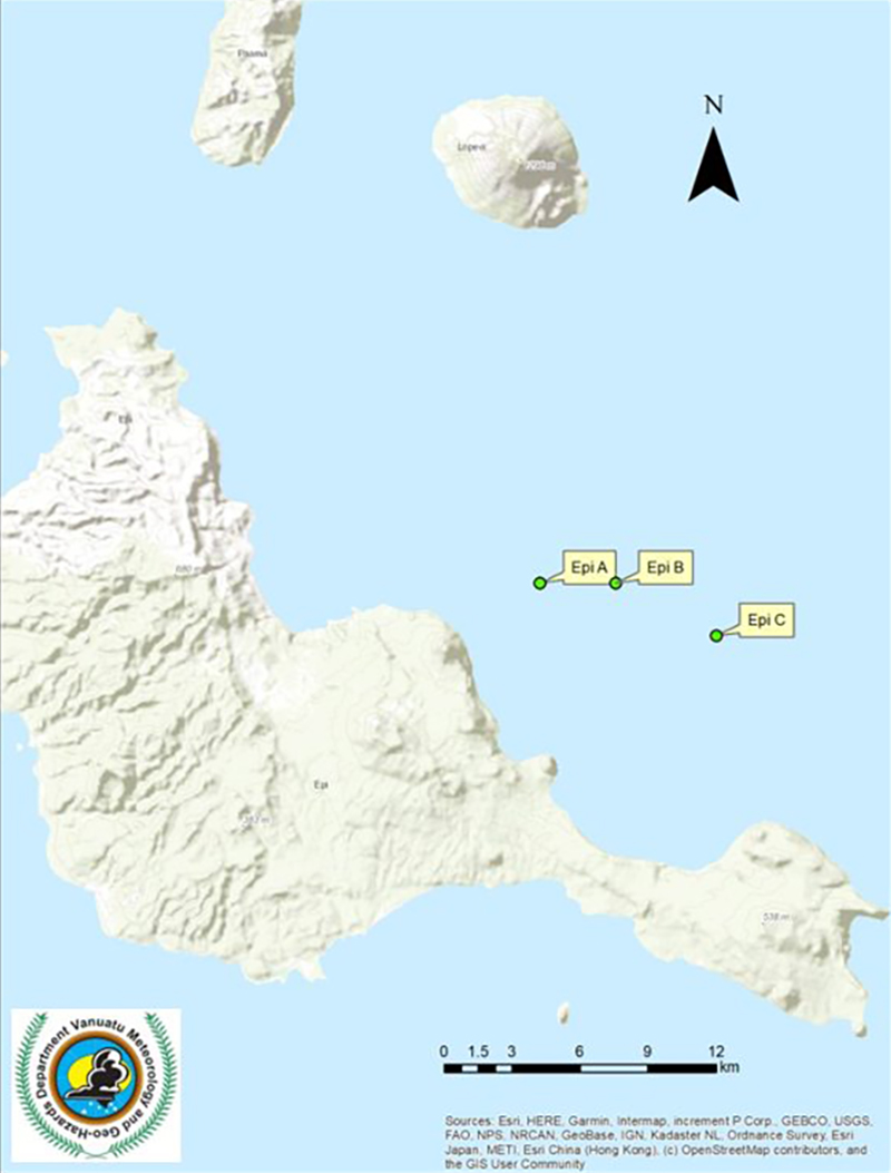 |
Figure 6. Location map showing the locations of the three main cones of the East Epi group (Epi A, Epi B, and Epi C) 4-10 km NNE of Epi Island. Epi B is the site of the 2023 activity. The small island ~16 km N of the cones (top center) is Lopevi volcano. Courtesy of VMGD. |
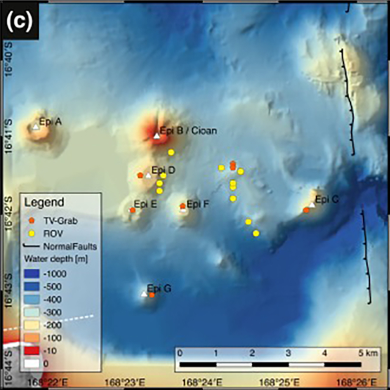 |
Figure 7. Detailed bathymetric map showing the submarine cones of the East Epi group from Beier at al. (2013, figure 1c). The bathymetric grid was compiled from GEBCO, high-resolution ship-based data from R/V Sonne cruise SO-229 (Haase et al., 2013), and digitized grids from VATATERM (Ballu and Calmant, 2004). |
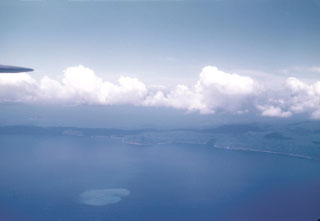
According to the Wellington VAAC, a low-level ash and sulfur dioxide plume was identified in satellite data at 0730 on 31 January 2023. VMGD reported that residents saw gas-and-steam emissions at the ocean’s surface around 0748 (figure 8) and phreatic explosions that ejected gas and tephra 100 m above the water (figure 9). Observers also reported that they saw a growing cone from ongoing ash emissions. The Wellington VAAC noted that the eruption was short-lived and had stopped by 1548 when the ash had dissipated. During an overflight on the afternoon of 31 January, gas-and-steam was observed rising from the ocean surface above Epi B, discolored water was visible around the eruption site, and pumice rafts were floating on the surface (figure 10). Several strands of pumice that drifted to the SW, NW, and N of Epi B were visible in Sentinel-2 satellite imagery on 2 and 14 February (figure 11). Gas-and-steam emissions were also visible at the surface for a few hours during 1 February. During 0700-1030 on 7 February residents observed minor, low-level gas-and-steam emissions above Epi B. The intensity of the gas-and-steam plumes varied, with stronger activity reported by local residents around 0600 on 8 February. On 23 February VMGD reported sustained seismicity and minor gas-and-steam plumes that only lasted a few hours.
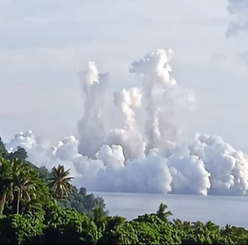 |
Figure 8. Photo of gas-and-steam plumes rising above East Epi on 31 January 2023 due to phreatic explosions. Photo by Mayline Leleny. Courtesy of VMGD. |
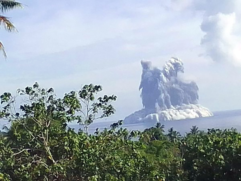 |
Figure 9. Photo of phreatic explosions and dark tephra ejected 100 m above East Epi on 31 January 2023. Photo by Mayline Leleny. Courtesy of VMGD. |
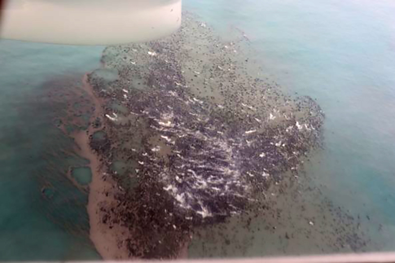 |
Figure 10. Aerial photo of pumice floating on the surface of the ocean during 31 January-1 February 2023 as a result of the phreatic explosions at East Epi on 31 January 2023. Photo has been color corrected. Courtesy of VMGD. |
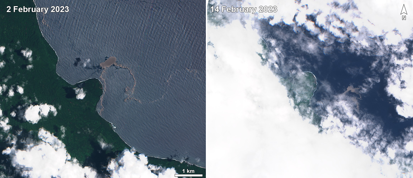 |
Figure 11. Sentinel-2 satellite images showing visible pumice rafts (dark gray) originating from East Epi that drifted SW and S toward Epi Island on 2 February (left) and 14 February 2023 (right). Images with “Natural color” rendering (bands 4, 3, 2). Courtesy of Sentinel Hub Playground. |
References. Ballu V, Calmant S, 2004. Campagne VATATERM du N.O. Alis au Vanuatu.
Beier C, Brandl P A, Lima S M, Haase K M, 2018. Tectonic control on the genesis of magmas in the New Hebrides arc (Vanuatu). Lithos, v. 312–313, p. 290-307. https://doi.org/10.1016/j.lithos.2018.05.011
Haase K M, Koschinsky A, Schwarz-Schampera U (Principal investigators for COVOLVE - COriolis VOLcanism and VEnts), and shipboard scientific party, 2013. Volcanism, hydrothermal activity and vent biology in the Coriolis Troughs, New Hebrides Island Arc; RV Sonne cruise SO-229, Cruise report / Fahrtbericht, 01.07.2013, Townsville (Australia) to 26.07.2013, Nouméa (New Caledonia). TIB – Leibniz Information Centre for Science and Technology and University Library, Erlangen, Germany. https://doi.org/10.2312/cr_so229
Geological Summary. The submarine East Epi group of basaltic and dacitic cones are located within a possible 10-km-diameter caldera off the NE coast of southern Epi Island in Vanuatu. Three cones (1-1.5 basal diameter), known as Epi A, Epi B (or Cioan), and Epi C, are located along the northern rim of the inferred caldera, though Beier et al. (2018) suggest an alternate to the post-caldera formation model. A few smaller cones are south of Epi B. Ephemeral islands were formed during eruptions at Epi B in 1920 and 1953. Explosive activity was reported in 1958 and 1960, discolored water was often seen during 1971-1974 and 1988, a new vent was detected in 1979, and explosive activity occurred in 1999, 2002, 2004, and 2023. The summit was at 34 m below sea level at the time of a 2001 survey, and a research cruise in 2013 (R/V Sonne SO-229; Haase et al, 2013) sampled six cones, including "very fresh pumice and lava bombs" from Epi B and "relatively old-looking" material from the others. The SO-229 cruise also recovered rhyodacitic pumice with mafic streaks, similar to that sampled by previous cruises, and described Epi B as "covered by massive blocks of pumice."
Information Contacts: Geo-Hazards Division, Vanuatu Meteorology and Geo-Hazards Department (VMGD), Ministry of Climate Change Adaptation, Meteorology, Geo-Hazards, Energy, Environment and Disaster Management, Private Mail Bag 9054, Lini Highway, Port Vila, Vanuatu (URL: http://www.vmgd.gov.vu/, https://www.facebook.com/VanuatuGeohazardsObservatory/); Wellington Volcanic Ash Advisory Centre (VAAC), Meteorological Service of New Zealand Ltd (MetService), PO Box 722, Wellington, New Zealand (URL: http://www.metservice.com/vaac/, http://www.ssd.noaa.gov/VAAC/OTH/NZ/messages.html); Sentinel Hub Playground (URL: https://www.sentinel-hub.com/explore/sentinel-playground).