Report on Erebus (Antarctica) — March 1976

Natural Science Event Bulletin, vol. 1, no. 6 (March 1976)
Managing Editor: David Squires.
Erebus (Antarctica) Crater lava lake increases in size since 1974-75 summe
Please cite this report as:
Global Volcanism Program, 1976. Report on Erebus (Antarctica) (Squires, D., ed.). Natural Science Event Bulletin, 1:6. Smithsonian Institution. https://doi.org/10.5479/si.GVP.NSEB197603-390020
Erebus
Antarctica
77.53°S, 167.17°E; summit elev. 3794 m
All times are local (unless otherwise noted)
The following information was extracted from the November/December issue of the Antarctic Journal of the United States. "The lava lake dimensions in Mount Erebus' inner crater (figure 1) has increased in size since the 1974-75 austral summer. This observation was made by four New Zealand scientists who camped near the volcano's summit 30 November-7 December 1975.
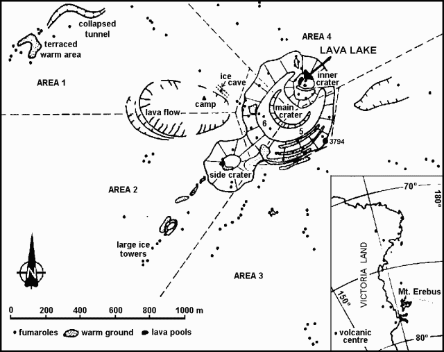 |
Figure 1. Summit region of Mt. Erebus, and its location. Ice towers are marked as fumaroles. After Lyon and Giggenbach, 1974. |
"Last season the lava covered only part of the N half of the inner crater, moving along a curved path originating at the E end and disappearing in a tunnel at the W end. A 14-person French-New Zealand-U.S. team made the observations during 1974-75, and attempted unsuccessfully to enter the inner crater. According to P.R. Kyle and W.F. Giggenbach, lava now fills the entire N half of the inner crater with the previously circular movement having been replaced by a series of overlapping areas where lava is welling up. An average of about two explosions per day were heard in the camp area; they appeared to be less violent, and were characterized by a more prolonged, whooshing noise compared to the short, sharp bangs heard during last season's visit. Only small pools of lava were observed 3 years ago. Since then a steady expansion in the area of exposed lava has taken place."
Reference. Lyon, G.L., and Giggenbach, W.F., 1974, Geothermal activity in Victoria Land, Antarctica: New Zealand Journal of Geology and Geophysics, v. 17, p. 511-521.
Geological Summary. Mount Erebus, the world's southernmost historically active volcano, overlooks the McMurdo research station on Ross Island. It is the largest of three major volcanoes forming the crudely triangular Ross Island. The summit of the dominantly phonolitic volcano has been modified by one or two generations of caldera formation. A summit plateau at about 3,200 m elevation marks the rim of the youngest caldera, which formed during the late-Pleistocene and within which the modern cone was constructed. An elliptical 500 x 600 m wide, 110-m-deep crater truncates the summit and contains an active lava lake within a 250-m-wide, 100-m-deep inner crater; other lava lakes are sometimes present. The glacier-covered volcano was erupting when first sighted by Captain James Ross in 1841. Continuous lava-lake activity with minor explosions, punctuated by occasional larger Strombolian explosions that eject bombs onto the crater rim, has been documented since 1972, but has probably been occurring for much of the volcano's recent history.
Information Contacts: P. Kyle, Inst. of Polar Studies, Ohio State Univ.; W. Giggenbach, DSIR, Wellington.