Report on Soufriere Guadeloupe (France) — June 1976
Natural Science Event Bulletin, vol. 1, no. 9 (June 1976)
Managing Editor: David Squires.
Soufriere Guadeloupe (France) Phreatic eruption on 8 July; crack opens in summit dome
Please cite this report as:
Global Volcanism Program, 1976. Report on Soufriere Guadeloupe (France) (Squires, D., ed.). Natural Science Event Bulletin, 1:9. Smithsonian Institution. https://doi.org/10.5479/si.GVP.NSEB197606-360060
Soufriere Guadeloupe
France
16.044°N, 61.664°W; summit elev. 1467 m
All times are local (unless otherwise noted)
On 8 July at approximately 0900, a phreatic eruption began at Soufrière (figure 1). A new crack, 300 m long [but see 1:10] and up to 10 m wide, opened down the SE side of the summit dome. Steam and gas with ash and lava fragments were blowing through the crack on that day, but on 9 July there were only steam and gas with no solids. The eruption appeared to be purely phreatic, with no molten material reported.
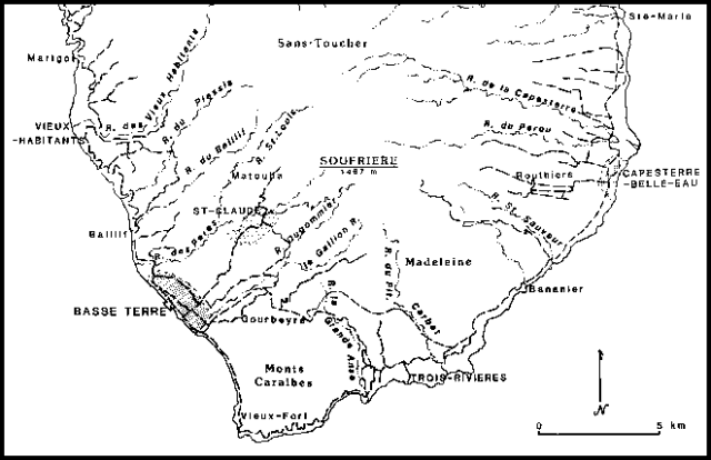 |
Figure 1. Map of the S part of Basse-Terre (one of the islands that comprise Guadeloupe). After Guadeloupe Tourist Map, 1:100,000, Institut Géographique National, 1982. |
On the 9th the gas and steam were venting at a "vast rate," and the column rose ~300 m above the crack. Steam and gas venting was continuing as of this report, but the activity appeared to be slowing down. It was not possible to ascertain the height of the steam column because of clouds. It is believed that local earthquakess occurred just before the eruptive activity began; longer-term premonitory seismicity was described in 1:8.
A phreatic eruption occurred in 1956 from a fracture across the top of the dome (figure 2), but the current eruption is bigger in that the crack is longer and the volume of products is greater. There were comparable phreatic eruptions in [1837-38] and 1797, each lasting a few days. The present activity appears to be following the pattern of these previous eruptions. Radiocarbon evidence indicates that there was a large magmatic eruption about 1500 A.D.
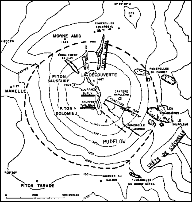 |
Figure 2. Map of the summit of Soufrière volcano, Guadeloupe, after Catalog of Active Volcanoes of the World. Heights are in meters. |
In general characteristics Soufrière is comparable to the Martinique and St. Vincent volcanoes, which are capable of extremely violent activity.
Geological Summary. La Soufrière de la Guadeloupe volcano occupies the southern end of Basse-Terre, the western half of the island of Guadeloupe. Construction of the Grand Découverte volcano about 200,000 years ago was followed a Plinian eruption and caldera formation about 100,000 years later, and then by construction of the Carmichaël volcano within the caldera. Two episodes of edifice collapse and associated large debris avalanches formed the Carmichaël and Amic craters about 11,500 and 3,100 years ago, respectively. The present volcano subsequently grew within the Amic crater. The summit consists of a flat-topped lava dome, and several other domes occur on the southern flanks. Six phreatic explosive eruptions since 1690 opened radial fractures across the summit lava dome. The phreatic eruptions in 1976-77 caused severe economic disruption when Basse-Terre, the island's capital city immediately below the volcano, was evacuated.
Information Contacts: J. Tomblin, UWI; Lab. de Physique du Globe.