Report on Kie Besi (Indonesia) — September 1976
Natural Science Event Bulletin, vol. 1, no. 12 (September 1976)
Managing Editor: David Squires.
Kie Besi (Indonesia) Investigation by volcanologists reveal no signs of activity
Please cite this report as:
Global Volcanism Program, 1976. Report on Kie Besi (Indonesia) (Squires, D., ed.). Natural Science Event Bulletin, 1:12. Smithsonian Institution. https://doi.org/10.5479/si.GVP.NSEB197609-268070
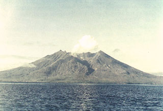
Kie Besi
Indonesia
0.32°N, 127.4°E; summit elev. 1357 m
All times are local (unless otherwise noted)
Fears of renewed activity at Makian, which last erupted in 1890, stemmed from earthquakes felt in the area in 1972. Investigations carried out between January 1973 and July 1976 by GSI volcanologists indicated that the earthquakes recorded were of tectonic origin and that the volcano shows no signs of renewed activity.
Geological Summary. Kie Besi volcano, forming the 10-km-wide Makian island off the west coast of Halmahera, has been the source of infrequent, but strong eruptions that have devastated villages on the island. The large 1.5-km-wide summit crater, containing a small lake on the NE side, gives the peak a flat-topped profile. Two prominent valleys extend to the coast from the summit crater on the north and east sides. Four cones are found on the western flanks. Eruption have been recorded since about 1550; major eruptions in 1646, 1760-61, 1861-62, 1890, and 1988 caused extensive damage and many fatalities.
Information Contacts: G. de Néve, GSI, Bandung.