Report on Soufriere Guadeloupe (France) — September 1976
Natural Science Event Bulletin, vol. 1, no. 12 (September 1976)
Managing Editor: David Squires.
Soufriere Guadeloupe (France) Variable activity continues; ash eruption on 22 September
Please cite this report as:
Global Volcanism Program, 1976. Report on Soufriere Guadeloupe (France) (Squires, D., ed.). Natural Science Event Bulletin, 1:12. Smithsonian Institution. https://doi.org/10.5479/si.GVP.NSEB197609-360060
Soufriere Guadeloupe
France
16.044°N, 61.664°W; summit elev. 1467 m
All times are local (unless otherwise noted)
16 September: Heavy steaming occurred from the S and SE sides of the summit dome. Differential magnetometer readings increased at the summit and decreased at Matouba with respect to a base station at Basse Terre.
17-19 September: Large inflation was shown by LANL tilt stations to continue through the 18th. Deflation was observed by the same stations on the 19th. Sulfur was noted in the gases on the 18th. Eruptive activity was minor.
20 September: A seismic event occurred at 0100. LANL reports that the tilt, gravity, differential magnetometry, and seismicity each showed distinctive patterns prior to this event, similar to the patterns noted before the 14 September activity. These data have yet to be interpreted in terms of a magma chamber model. LANL noted approximately 10 µrad inflation at the summit, and ~5 µrad deflation at lower tilt stations during the the 24 hours after the event.
21 September: Eruptive activity was minor.
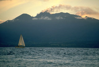
22 September: An ash eruption, producing a 3,500-m cloud, occurred at 0645, accompanied by 18 minutes of harmonic tremor, 6 minutes of which saturated seismographs. About 1 cm of ash fell downwind at Baillif-Vieux-Habitants. Ash was sampled from a 1-mm deposit near the S edge of the ashfall area.
23 September: Strong steaming, possibly with some ash emission, was occasionally visible through heavy clouds.
24-27 September: The activity stabilized to moderate steaming and minor ash emission. LANL recorded a large tilt episode, beginning at 2300 on the 27th and lasting several hours.
28 September: A 300-m plume was visible for much of the day. At 1010 an earthquake occurred that was felt in Pointe-a-Pitre. Seventy minutes later, LANL recorded the beginning of deflation. The tilt and seismic data are thought by LANL to indicate cavity collapse.
29 September: LANLLASL reported the beginning of inflation at 1445, then deflation at 1745.
30 September: A 20-minute period of tremors began at 0002. Two large and four small events were recorded. Cavity collapse was again suggested by LANL as an explanation for the seismic episode.
In other tilt experiments, R.S. Fiske and W.T. Kinoshita, supported by the USGS, SI, and OFDA, established four dry-tilt arrays on the SW flank of Soufrière in late August. These four arrays are at about 1, 3, 4, and 5 km from the summit. More than 25 reoccupations of these arrays (29 August-30 September) by French technicians have indicated daily station "noise" sometimes exceeding 5 µrad, but the suggestion of true volcano inflation has been recorded only at the station 5 km from the summit. The bulk of the dry-tilt data gathered to date therefore do not indicate that the volcano is being deformed as a result of the inflation of a magma reservoir. This tentative conclusion is supported by measurements of P.A. Blum, who installed two pendulum-type tiltmeters at the now abandoned volcano observatory about 3 km from the summit. These tiltmeters, capable of detecting changes in ground tilt of a few parts in 108, have indicated tilt changes of only fractions of a µrad from 25 September, when measurements were begun, to 29 September. Neither of these observations, however, has been made over times that would record the short periods of tilt reported by LANL during the hour preceding small eruptions.
[Magnetic variations measured on the volcano in September were positive at all but one station, and intense, reaching 6nT at the end of the month (Zlotnicki, 1986).]
Earlier reports of fresh volcanic glass in the ejected ash from La Soufrière are now regarded to have been in error. There is no confirmed evidence that juvenile magma has reached the surface.
Geological Summary. La Soufrière de la Guadeloupe volcano occupies the southern end of Basse-Terre, the western half of the island of Guadeloupe. Construction of the Grand Découverte volcano about 200,000 years ago was followed a Plinian eruption and caldera formation about 100,000 years later, and then by construction of the Carmichaël volcano within the caldera. Two episodes of edifice collapse and associated large debris avalanches formed the Carmichaël and Amic craters about 11,500 and 3,100 years ago, respectively. The present volcano subsequently grew within the Amic crater. The summit consists of a flat-topped lava dome, and several other domes occur on the southern flanks. Six phreatic explosive eruptions since 1690 opened radial fractures across the summit lava dome. The phreatic eruptions in 1976-77 caused severe economic disruption when Basse-Terre, the island's capital city immediately below the volcano, was evacuated.
Information Contacts: W. Aspinall and J. Tomblin, UWI; LANL; J. Gautheyrou, ORSTOM; R. Fiske, SI.