Report on Kadovar (Papua New Guinea) — November 1976
Natural Science Event Bulletin, vol. 1, no. 14 (November 1976)
Managing Editor: David Squires.
Kadovar (Papua New Guinea) Expansion of fumarolic area during September-November
Please cite this report as:
Global Volcanism Program, 1976. Report on Kadovar (Papua New Guinea) (Squires, D., ed.). Natural Science Event Bulletin, 1:14. Smithsonian Institution. https://doi.org/10.5479/si.GVP.NSEB197611-251002
Kadovar
Papua New Guinea
3.608°S, 144.588°E; summit elev. 365 m
All times are local (unless otherwise noted)
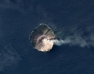
Kadovar is a 365-m-high, 1.4 km-diameter volcanic island. A 1700 report of smoke seen briefly there was believed at the time to be a volcanic eruption. Since then no eruptions are known, and no traces of thermal activity remained in early 1976, although there was supposedly some such activity several generations ago. The island has the form of a steep-sided cone 250 m high, with a 600-m-wide crater breached to the SSE. The breach probably extended at least to sea level, but the crater and breach are now occupied by a high-standing, conical lava dome. The island is completely vegetated, and supported a village of more than 300 people built around the crater rim. Most of the village gardens are on the side of the dome.
In early August 1976, the first reports were received of activity there, the precise nature of which has not been clearly established. A summary of events to mid-November, and of investigations so far carried out, follows.
May-June 1976. The precise nature of the early events is not clear. Some sort of disturbance seems to have taken place in the sea just off (50 m?) the S coast, which may have been a small hydrothermal eruption or, more likely, a vigorous ebullition of gas bubbles. Weak earth tremors were felt, apparently during the preceding few days, and an explosive sound was heard. Scum was noticed on the water, persisting for a few days, and reddish coloration appeared on the rocks in the tidal zone at one point on the S coast.
August 1976. An investigation [on 3 August] was made by Rabaul Volcano Observatory (RVO) volcanologists D. Wallace and R. Almond. The only effect of the earlier activity was a 100 m-long reddish zone of iron hydroxide discoloration at sea level, and associated sea discoloration. No thermal activity or other unusual phenomena were observed, and no definite volcano-seismic activity was recorded during 5 hours operation of a portable seismograph.
September 1976. Hot ground was first noticed midway up the side of the lava dome about 16 September. An investigation [on 26 September] was made by volcanologist R. Cooke. The coastal discoloration was more extensive than in August, and ground temperatures up to 49°C were present in this zone. The reported hot ground on the mid-slope of the dome was about 30 m x 15 m in area, and was producing vigorous emissions of SO2 and HCl gases (indicated by Dräger tubes) from one main vent and numerous minor vents, at temperatures up to 99.7°C. The white gas column was visible above the treetops from the boat, but only minor vegetation damage had occurred. A newly formed small, weak patch of hot ground was found 100-200 m upslope of the main fumarole area. No volcano-seismic activity was recorded during 5.5 hours with a portable seismograph.
October 1976. Government officers R. Allen and D. Mahar from Wewak inspected the fumarole area [on 14 October], which had intensified in activity and was about 150 x 50 m in area. The expansion had proceeded principally upslope. [On 23 October] D. Mahar again inspected the fumarole area, which had further enlarged. All vegetation in the area had been killed.
November 1976. An investigation [during 10-12 November] was made by volcanologist V. Dent, physicist D. Norris (University of Papua New Guinea, Port Moresby), and D. Mahar. The main fumarole area had enlarged again and was estimated at about 150 x 70 m, and the area of dead vegetation was more prominent. A second main fumarole vent had developed 20 m downslope of the original main vent of September, but the principal expansion since then had been upslope, and to the E. The maximum temperature measured was again about 99°C. Collections of fumarole gas were made in evacuated glass tubes containing silica gel, and gas condensates were also collected. The maximum ground temperature in the S coast discolored zone was 49.5°C, similar to September. About 50 hours recording by a portable seismograph produced 5-10 very small and close A-type events. A seismic event counter was installed on the island. D. Norris carried out a total magnetic field survey of the island using a proton magnotometer.
It is intended to continue regular inspection visits to the volcano, but a full-time observation post is not planned at this time. Such a post will be established, probably on Blupblup Island, 13 km north of Kadovar, when an eruption is believed to be imminent, or once an eruption has commenced. All residents of Kadovar have been evacuated to Blupblup Island.
Geological Summary. The 2-km-wide island of Kadovar is the emergent summit of a Bismarck Sea stratovolcano of Holocene age. It is part of the Schouten Islands, and lies off the coast of New Guinea, about 25 km N of the mouth of the Sepik River. Prior to an eruption that began in 2018, a lava dome formed the high point of the andesitic volcano, filling an arcuate landslide scarp open to the south; submarine debris-avalanche deposits occur in that direction. Thick lava flows with columnar jointing forms low cliffs along the coast. The youthful island lacks fringing or offshore reefs. A period of heightened thermal phenomena took place in 1976. An eruption began in January 2018 that included lava effusion from vents at the summit and at the E coast.
Information Contacts: R. Cooke, RVO.