Report on Karangetang (Indonesia) — November 1976

Natural Science Event Bulletin, vol. 1, no. 14 (November 1976)
Managing Editor: David Squires.
Karangetang (Indonesia) Additional details of September-October eruptive activity
Please cite this report as:
Global Volcanism Program, 1976. Report on Karangetang (Indonesia) (Squires, D., ed.). Natural Science Event Bulletin, 1:14. Smithsonian Institution. https://doi.org/10.5479/si.GVP.NSEB197611-267020
Karangetang
Indonesia
2.781°N, 125.407°E; summit elev. 1797 m
All times are local (unless otherwise noted)
The following additional information is from a report by scientists from the Volcano Observation Section, Geological Survey of Indonesia.
The eruption was preceded by an earthquake swarm that began on 4 September. The number of felt earthquakes reached a maximum of 120/day early in the swarm, then gradually declined. At 0700 on 15 September, a minor pyroclastic eruption began from a new vent (A in figure 1) at about 1100 m elevation on the S flank, producing a thick ash cloud. This activity was succeeded by lava effusion from vent A. Another pyroclastic eruption occurred on 17 September from a second new vent (B in figure 1), about 300 m S of vent A. Lava effusion began shortly afterwards from B. The two flows coalesced near vent B and moved downslope 200-300 m/day. The rate of movement gradually decreased to 10 m/day as the flow front reached more level terrain. By 21 October, the flow was ~ 50 m thick near its source, ~6 km long, and was only 400 m from Ulu City, but lava extrusion had apparently ended. The flow front continued to advance 5-10 m/day. Thick "smoke" was still being emitted from the summit crater Karangetang. Lava volume was estimated at 2 x l07 m3.
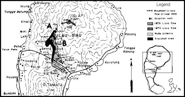 |
Figure 1. Map of Api Siau, showing the 1974 and 1976 lava flows and the 1976 nuée ardente deposits. Courtesy of VSI. |
Geological Summary. Karangetang (Api Siau) volcano lies at the northern end of the island of Siau, about 125 km NNE of the NE-most point of Sulawesi. The stratovolcano contains five summit craters along a N-S line. It is one of Indonesia's most active volcanoes, with more than 40 eruptions recorded since 1675 and many additional small eruptions that were not documented (Neumann van Padang, 1951). Twentieth-century eruptions have included frequent explosive activity sometimes accompanied by pyroclastic flows and lahars. Lava dome growth has occurred in the summit craters; collapse of lava flow fronts have produced pyroclastic flows.
Information Contacts: D. Hadikusumo, VSI.