Report on Piton de la Fournaise (France) — April 1977

Natural Science Event Bulletin, vol. 2, no. 4 (April 1977)
Managing Editor: David Squires.
Piton de la Fournaise (France) Summary of first flank activity since 1800
Please cite this report as:
Global Volcanism Program, 1977. Report on Piton de la Fournaise (France) (Squires, D., ed.). Natural Science Event Bulletin, 2:4. Smithsonian Institution. https://doi.org/10.5479/si.GVP.NSEB197704-233020
Piton de la Fournaise
France
21.244°S, 55.708°E; summit elev. 2632 m
All times are local (unless otherwise noted)
A new eruption of Piton de la Fournaise included its first flank activity since 1800. The following is a summary of events.
[24] March: Four fissures opened at 2,000 m altitude on the SE flank of the main crater (Dolomieu) and emitted lava for half a day.
4 April: Felt tremors began.
5 April: At 1700 a 500-m fissure opened at 1,900 m altitude in the NE quarter of the caldera (figure 1 and table 1) and extruded lava until the morning of 7 April.
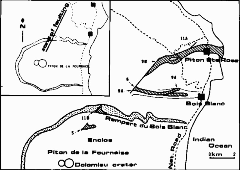 |
Figure 1. Map of the fissures and lava flows at Piton de la Fournaise, 5-16 April 1977. The number beside each flow represents the date (in April) on which extrusion began. Vents 8, 9A, and 9B form a continuous fissure, and flows 8 and 9B overlap for most of their lengths. Courtesy of Maurice Krafft. |
Table 1. April 1977 lava flows at Piton de la Fournaise and their durations of extrusion. Flow numbers are from figure 1. Dates are separated from start and stop times by colons.
| Flow | Start | Stop |
| 5 | 05 April : 1700 | 07 April : 1200 |
| 8 | 08 April : 1900 | 09 April : 1000 |
| 8 | 12 April : 1400 | 12 April : 2400 |
| 9A | 09 April : 0700 | 09 April : 1200 |
| 9B | 09 April : 0930 | 10 April : 1000 |
| 9B | 13 April : 0100 | 16 April : 1200 |
| 11A | 11 April : 1200 | 11 April : 1800 |
| 11B | 11 April : 1630 | 11 April : 2100 |
8 April: At 1900 an explosion was heard and a fissure opened at 1,300 m altitude on the N flank, producing lava fountains, gas, and a lava flow. The flow ceased 500 m from the village of Boisblanc during the night of 9 April.
9 April: A new fissure formed at 0700 near the 8 April fissure, extruding a lava flow that reached 700 m altitude. At 1100 another fissure opened (3 km N of the two previous ones) at 600 m altitude, from which a 50-m-wide flow moved during the night through the village of Sainte Rose, destroying 12 houses (figure 2). It widened to 250 m and reached the sea between 0230 and 0300 on 10 April.
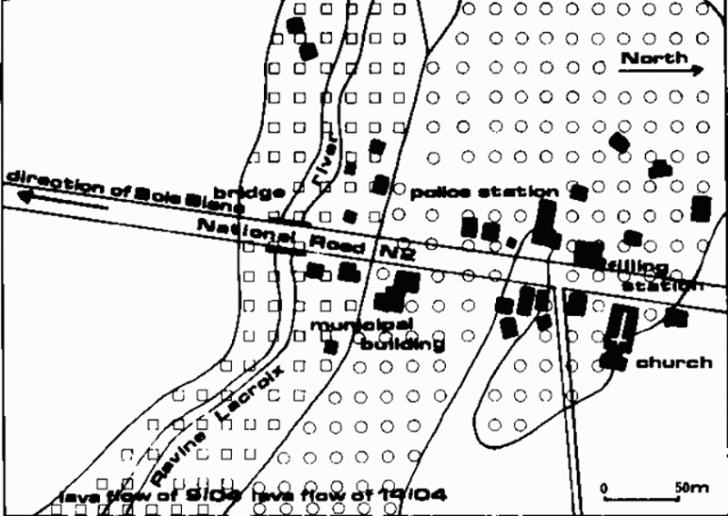 |
Figure 2. Map of lava flows from Piton de la Fournaise through the village of Piton Ste. Rose, April 1977. Courtesy of Maurice Krafft. |
11 April: A new fissure opened 500 m N of Sainte Rose but emitted only gas. During the afternoon, lava flowed towards the sea from the caldera (L'Enclos) [see 2:5].
12 April: Earlier flows stopped, but new activity, lasting from afternoon until about midnight, began at 1,500 m altitude above Boisblanc, near the 8-9 April eruption sites.
13 April: Lava again flowed from the NE quarter of the caldera during the morning [but see 2:5]. Lava extrusion resumed at 0100 from the fissure that had opened 9 April above Sainte Rose. The new flow reached the village at 1830, destroyed 21 houses and a church (figures 3 and 4), and entered the sea at 2200. About 1,000 people were evacuated, but no casualties were reported.
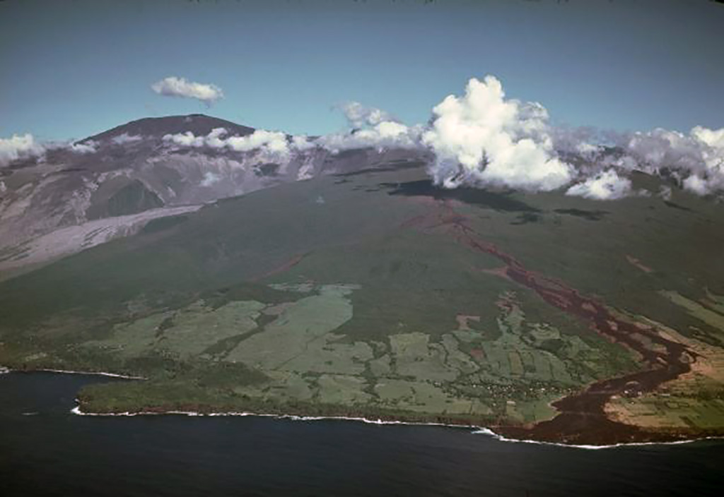 |
Figure 3. Oblique airphoto of Piton de la Fournaise looking SW. Flow 9B (of 9 April 1977) can be seen reaching the sea at right, and the caldera is at left. Photo by Maurice Krafft. |
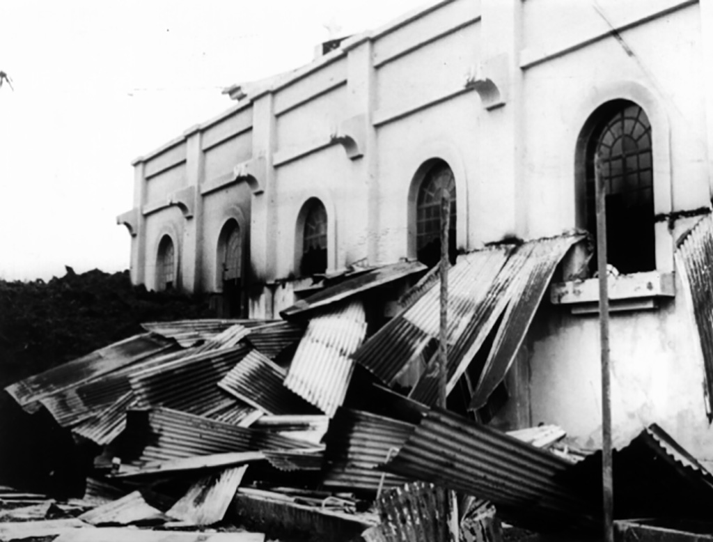 |
Figure 4. Destruction, by the lava flow at left from Piton de la Fournaise, of the church of Piton Ste. Rose, April 1977. Photo by Maurice Krafft. |
Geological Summary. Piton de la Fournaise is a massive basaltic shield volcano on the French island of Réunion in the western Indian Ocean. Much of its more than 530,000-year history overlapped with eruptions of the deeply dissected Piton des Neiges shield volcano to the NW. Three scarps formed at about 250,000, 65,000, and less than 5,000 years ago by progressive eastward slumping, leaving caldera-sized embayments open to the E and SE. Numerous pyroclastic cones are present on the floor of the scarps and their outer flanks. Most recorded eruptions have originated from the summit and flanks of Dolomieu, a 400-m-high lava shield that has grown within the youngest scarp, which is about 9 km wide and about 13 km from the western wall to the ocean on the E side. More than 150 eruptions, most of which have produced fluid basaltic lava flows, have occurred since the 17th century. Only six eruptions, in 1708, 1774, 1776, 1800, 1977, and 1986, have originated from fissures outside the scarps.
Information Contacts: M. Krafft, Ensisheim; P. de Saint Ours, St. Maurice.